4 produkter
4 produkter


Ecuador: Galapagos Islands (Quito & Guayaquil)
Ordinær pris 199,00 kr/
Mva inkludert
Frakt beregnes i kassen.
The Galapagos archipelago is a little difficult to reach, in that all flights must originate in Ecuador, necessitating adding maps for both Quito and Guayaquil to this map of the islands as those are the two cities flights leave from to reach the access airport on one of the islands. Naturally, visitors go for one reason – to see exotic wildlife in a truly unique way. One can only explore the Galapagos as part of a tour, so making advance bookings with a small or big ship is absolutely essential. We have endeavoured to locate the most likely viewing areas for iguanas, turtles, seals, and booby birds, but wild creatures tend to move around, and one must use an experienced guide to locate them. That said, much of the island grouping is as pristine as it was when the HMS Beagle hove to two hundred years ago and disgorged a young Charles Darwin to gaze in wonder at wild species with no ingrained fear of humans, eventually developing the concept of evolution that now is generally accepted as fact.
The map of Quito occupies the reverse side of the sheet. The old airport is no longer used and the new airport is quite distant from the city. Guayaquil is a large inset on the islands side. All of the photos on the map were taken by ourselves during a visit to the Galapagos. It should be noted that thousands of people live in the islands, mostly around Puerto Ayora.
- Publisert: 2022
- Innbinding: Falset
- Materiale: Papir
- Målestokk: 1:350 000, 1:12 400, 1:10 000

Ecuador: Quito & Central Ecuador
Ordinær pris 169,00 kr/
Mva inkludert
Frakt beregnes i kassen.
ITM har kart over hele verden og de spesialiserer seg på land litt utenfor allfarvei. Beliggenheten til landets nasjonalparker, historiske monumenter, de viktigste veiene o.L. Finner du inkludert i kartene. Samtlige landkart har ofte et bykart over hovedstaden.
Fra ITM: ITMB releases its long-awaited re-worked map of the wonderful South American city of Quito. The city is squeezed in between mountain ranges and, the entire city stretches from north (on the right-hand side of the map) to south. The ‘bottom’ of the map is, actually the eastern portion. A regional inset map clarifies the situation. The street network is clearly shown, along with the rapid line busway and the city’s Metro. The Old Town is perhaps the most interesting portion of the city for visitors and is on the left-hand portion of the map. The newer downtown is centred on La Carolina Park on the right-hand side of the map. This is where most of the shopping malls and hotels are located. The old airport is shown in part on the far right, but the new international airport is located far out of town. It is shown on the inset map. The reverse side of the sheet covers all of central Ecuador in a north-south format, from Ibarra in the north to Loja in the south and from Guayaquil in the west to the edge of the vast Amazon jungle. This side also includes inset maps of central Guayaquil and of Isla Santa Cruz. The road network is shown in excellent detail. The country has only one major north-south highway, the Pan-Americano and most of the population lives along the spine of the Andes Mountains. Most visitors combine a trip to Quito with a flight to the fascinating Galapagos Islands (see separate map), which can also be reached from Guayaquil. However, the World Heritage city of Cuenca, in the far south is a treat that should not be missed!
Publisert år: 2019
Innbinding: falset
Material: papir
Målestokk: 1:12,400 / 1:600,000

South America
Ordinær pris 249,00 kr/
Mva inkludert
Frakt beregnes i kassen.
ITM har kart over hele verden og de spesialiserer seg på land litt utenfor allfarvei. Beliggenheten til landets nasjonalparker, historiske monumenter, de viktigste veiene og lignende finner du inkludert i kartene. Samtlige landkart har ofte et bykart over hovedstaden.
Fra ITM: South America as a continent is fascinating. For many years, ITMB has provided this map, either in its original version of two single sided map or a double sided map, such as this. We spent a lot of time reviewing the artwork and updating information from more detailed maps. The resulting map is a considerable improvement on the previous edition. The print is remarkable clear and easy to read. Road categories, road numbers of highways, parks, major history and touristic information have all been updated. This is a fascinating continent, and this map is the definitive map of the continent
- Publisert: 2019
- Innbinding: Falset
- Materiale: Papir
- Målestokk: 1:4 000 000


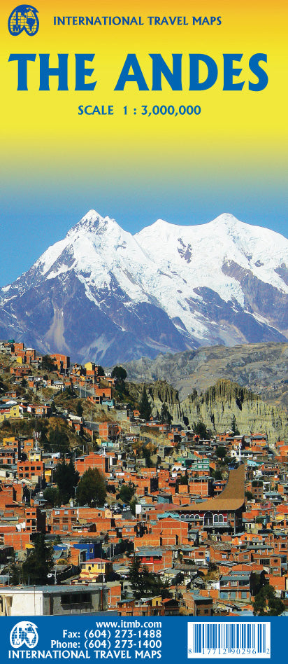
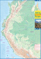
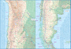
The Andes
Ordinær pris 199,00 kr/
Mva inkludert
Frakt beregnes i kassen.
We are pleased to be able to re-introduce this important title into our publishing range after a lapse caused by Covid. The Andes mountain chain is the southern extension of the Sierra Nevada chain through Mexico and Central America, which is, in turn the southern extension of the Rocky Mountain chain from Alaska to the Mexican border. The Andes is a magnificent series of high mountains that enters Colombia and spreads southwards through Ecuador and Peru all the way to southern Patagonia.
The map is double-sided, with the Northern Andes on one side and the other side divided into two side-by-side maps portraying the Central Andes and the Southern Andes. Thus, the map coverage focuses on the Andes themselves, rather than on all of South America. All of Colombia and Peru are shown, most of Bolivia, all of Chile, and the Patagonian portion of Argentina except for the southern portion of Tierra del Fuego. The importance of this map is that it focuses on the highland areas of the continent, where much of the population lives. Bogota, Medellin, Quito, Lima, Arequipa, La Paz, Santiago, Talca, and Punta Arenas are all located along the spine of the Andes. So are the Torres del Paine peaks, the Montt Glacier, and numerous volcanoes, touristic sites, and twisting mountain roads.
- Publisert: 2022
- Innbinding: Falset
- Materiael: Papir
- Målestokk: 1:3 000 000