31 produkter
31 produkter
31 produkter
Albania
Ordinær pris 199,00 krAlbania at 1:150,000 on a very large, indexed, double-sided road map from Freytag & Berndt prominently highlighting publishers’ recommendations of 10 best sights, each described in the accompanying booklet. The map divides north/south with Tirana included on both sides.
The country’s topography is vividly presented by relief shading, with spot heights and names of mountain ranges, etc. National parks and other protected areas are highlighted. Road network includes small local roads, most shown with driving distances. Scenic routes are highlighted. Railway lines are shown with stations and regional airports are marked. The map also shows internal administrative boundaries with names of the provinces. Symbols indicate various facilities and places of interest including campsites. The publishers’ recommendations of the country’s 10 best sights are prominently highlighted and have multilingual descriptions provided in the index booklet attached to the map cover. Latitude and longitude lines are drawn on the map at 10’ intervals. Map legend and the descriptions include English.
Albania
Ordinær pris 299,00 krThis new, fully revised seventh edition of Bradt's Albania remains the most authoritative standalone guide to what is still a relatively little known part of Europe. Coverage is comprehensive, starting in the capital, Tirana, then moving through central, northern and southern Albania to provide all the information needed for a successful trip. Included are knowledgeable and rigorously researched historical and archaeological background, detailed notes on popular and less well-known hiking routes and other outdoor activities, and specialist contributions on wildlife, military history and other topics.
An unparalleled wealth of practical advice for the independent traveller is also offered. Albania has something to offer almost everyone. Many come for the spectacular, unspoilt mountain scenery and the hiking and cycling opportunities.
Others are interested in the country's heritage, such as the Ottoman cities of Gjirokastra and Berati (both UNESCO World Heritage Sites), the many outstanding archaeological sites, and the Byzantine religious art in the medieval churches and in museums in Tirana, Korca and Berati. Beaches such as Dhermiu and Jala in the south are popular with young backpackers, while in high season the resorts are full of Albanian-speaking Kosovars and Macedonians. Ornithologists have long been attracted to Albania, even during the Communist period when the country was all but closed to most foreign visitors, thanks to its many different habitats and the fact it lies on several migration routes.
Albania
Ordinær pris 229,00 krReise Know-How maps (world mapping project series) are easy-to-read, waterproof and highly durable travel maps specifically designed for everyday use on the road.
Our maps combine state-of-the-art, GPS-compatible cartography (including hypsometric tints and contour lines) with a detailed rendering of road networks and touristic information. They offer the best possible scale, level of detail and readability, be it a map of a small island or half a continent.
The maps feature a detachable paper sleeve so that the maps can be folded easily and fit in every pocket. Although printed on plastic, a special coating makes sure the maps retain a paper-like feel and can even be written on with a pencil.
Albania
Ordinær pris 199,00 krAlbania
Ordinær pris 279,00 krIdeal for independent travellers, this guidebook to the Albania, written by destination experts, combines must-see sights with hidden gems and offers essential tips for both planning and on-the-ground adventures. It's sustainably printed to ensure environmental responsibility. Inside this Albania travel book, you'll find:- Regional deep dive - coverage of key regions, offering a rich selection of places and experiences, and honest reviews of each one- Itinerary samples - designed for various durations and interests- Practical information - tips on how to get there and get around, use public transport, beat the crowds, save time and money, travel responsibly and more- Expert recommendations - insider advice on where to eat, drink, and stay, alongside tips for nightlife and outdoor activities- Seasonal tips - when to go to the Albania, climate details, and festival highlights to plan your perfect trip- Must-See pick - a curated selection of not-to-miss sights as chosen by our authors - Tirana, Berat Castle, Ksamil, Gjirokastër, Butrint, Mount Dajti, Theth, Blue Eye, festivals, vineyards, white-water rafting the Vjosa River, Rozafa Castle- Navigational maps - colour-coded maps highlighting essential spots for dining, accommodation, shopping and entertainment.
Albania & North Macedonia
Ordinær pris 199,00 krThe ideal map for your trip. Let the Marco Polo Croatia Road Map guide you around this fascinating region of eastern Europe. Discover one of Europe's most beautiful coastlines with this highly durable, detailed, touring map of Croatia which also covers most of the Balkans. It folds away easily and is always on standby to help when you're stuck.
Albania, Kosovo & Montenegro - Hiking, Biking & Climbing
Ordinær pris 169,00 krA locally researched and produced cycling and hiking map in the border triangle Albania - Montenegro - Kosovo. Routes described in detail invite you to actively explore this largely untouched area. Places of intrest are described and illustrated on the reverse. In addition to two overview maps of the Albanian Alps, there are numerous other helpful facts about the country.
Balkans & Peaks of the Balkans
Ordinær pris 179,00 krThe portion of Europe east of the Adriatic and west of the Black Sea and south of the Alps has traditionally formed the region known as the Balkan States. This includes the former Yugoslavian states of Slovenia, Slovakia, Croatia, Montenegro, Bosnia Herzegovina, Kosovo, Serbia, and Northern Macedonia, as well as Albania, Hungary, Romania, and Bulgaria. Due to its shape, a large portion of Greece, and a bit of Turkey also are included. This is a new area of mapping for us, resulting from numerous visits to the region It is essentially a road map, as the rail network is weak, although rail lines carrying passengers are shown. Nice though the regional map is, its strength lies in the hiking map of the Peaks of the Balkans on the other side.
This detailed map is centred on eastern Montenegro, northern Albania, and western Kosovo. The ten major hiking routes are shown in pink, and there are numerous secondary routes one can explore. This is a growing touristic destination for those seeking a semi-wilderness area for enjoyment, while remaining in Europe, and is becoming quite popular. Accommodations are comprehensively shown, as well as campsites. Contouring is shown, and many peaks are noted. It should be stated that, as these paths cross international borders, hikers should keep their passports handy for inspection Legend Includes: Roads by classification, Rivers and Lakes, National Park, Airports, Points of Interests, Highways, Main Roads, Zoos, Fishing, and much more...
Balkans Western
Ordinær pris 199,00 krHighly tear-resistant and 100% waterproof map "Western Balkan Region" from the series world mapping project.
Travel know-how maps are characterized by particularly sturdy plastic paper, which can be written on like paper, even with a pencil. The cardboard envelope is removable, making it easy to put the card in any pocket. A protective cover is not required. The cartographic representation focuses on the most important information for travellers and is particularly easy to read. Instead of shading, coloured layers of elevation are used.
Balkans Western Road Atlas
Ordinær pris 449,00 krDette veiatlaset er lett å lese. Med mange symboler gis det informasjon fra blant annet campingplasser, fergetilbud og (ungdoms)herberger.
Veinettet er godt representert, både hovedveier, provinsveier og lokalveier. Veinummer er også tydelig oppgitt. Avstander mellom steder er markert på kartet i kilometer, og bensinstasjoner er også markert på viktige steder.
Shadow viser relieffet og noen ganger noen punkter med den faktiske høyden. Provinsgrenser, nasjonalparker og reservater er enkle å finne. Symboler indikerer plasseringen av turiststeder, monumenter, historisk viktige steder og utsiktspunkter. Enkelte steder kan du finne hoteller og campingplasser, flyplasser, togforbindelser og havner.
Croatia; Serbia
Ordinær pris 189,00 krAlso includes: Slovenia; Bosnia+Herz.; Kosovo; Montenegro; Albania; North Macedonia
The ideal map for your trip. Let the Marco Polo Croatia Road Map guide you around this fascinating region of eastern Europe. Discover one of Europe's most beautiful coastlines with this highly durable, detailed, touring map of Croatia which also covers most of the Balkans. It folds away easily and is always on standby to help when you're stuck.
Eastern Europe
Ordinær pris 249,00 krLonely Planet’s Eastern Europe is your passport to the most relevant, up-to-date advice on what to see and skip, and what hidden discoveries await you. Walk Dubrovnik’s city walls, discover history in Krakow, and explore Moscow’s Red Square; all with your trusted travel companion. Get to the heart of Eastern Europe and begin your journey now!
Covers Albania, Belarus, Bosnia & Hercegovina, Bulgaria, Croatia, Czech Republic, Estonia, Hungary, Kosovo, Latvia, Lithuania, Moldova, Montenegro, North Macedonia, Poland, Romania, Russia, Serbia, Slovakia, Slovenia, Ukraine.
Europe Eastern: Railway & Road
Ordinær pris 199,00 krEurope may be small in comparison to Canada, but it is densely populated and difficult to map as a continent while providing detail. Eastern Europe used to be defined as everything behind the Iron Curtain during the Cold War, but now it encompasses everything east of Germany and Switzerland, which means that this map covers Italy, Greece and the Balkan countries, the Central European countries of Romania and Hungary and most of Ukraine, Poland and the three Baltic states, and western Russia as far east as Volgograd, as well as much of Turkey. It is a combined road and rail map, showing motorways and major highways, fast-train routes in red and regular services in black. It also shows major cruise line routes, although many have been suspended due to Covid and political situations in Russia and Turkey.
Essentially, this is a map covering a very large area, as are our maps of Western and Central Europe, and our earlier map of Scandinavia. We have tried to make it politically correct, which is difficult considering the Russian occupation of Crimea and the Donetsk region of Ukraine and the on-going controversy over the ‘proper’ name for Macedonia, so we apologize for any errors. For simplicity’s sake, we have named most place names in English, so Roma is Rome and Moscva is Moscow etc. Fortunately, most English place names are the same in the local languages. However, being ITMB, Naples is Napoli, and Florence is Firenze, so don’t be too critical of us; we’re trying to reconcile differing perspectives.
Europe on a Budget
Ordinær pris 369,00 krThe Rough Guide to Europe on a Budget is the definitive guide to making the most of this great region without breaking the bank. Backpackers, career-breakers, gap-year travellers and those who simply want more bang for their buck will find in-depth information catering to their needs, with in-depth, area-by-area comprehensive listings covering the whole Europe.
The Rough Guide to Europe on a budget covers: Albania, Austria, Belgium & Luxembourg, Bosnia-Herzegovina, Bulgaria, Croatia, Czech Republic, Denmark, Estonia, Finland, France, Germany, Great Britain, Greece, Hungary, Ireland, Italy, Latvia, Lithuania, Macedonia, Montenegro, Morocco, The Netherlands, Norway, Poland, Portugal, Romania, Russia, Serbia, Slovakia, Slovenia, Spain, Sweden, Switzerland, Turkey and Ukraine.
Europe: Southeast & Balkans
Ordinær pris 199,00 krThe Balkans and South-Eastern Europe on a road map from Freytag and Berndt, covering a large chunk of the Continent from southern Poland and Kiev to the Mediterranean, and from Naples to Ankara. The map shows the area’s road network, indicating diving distances on principal routes and main border crossings. Railways and ferry routes are marked. In most countries internal administrative boundaries are also shown.
In Greece, Bulgaria and Ukraine (but not Serbia) names of main cities are shown both in Latin alphabet and in Greek or Cyrillic. The map has a latitude and longitude grid at intervals of 1º. Multilingual map legend includes English.
A booklet attached to the map cover contains an index, arranged by country, plus street plan of central Athens, Belgrade, Bratislava, Budapest, Bucharest, Chisinau, Istanbul, Kiev, Ljubljana, Podgorica, Prague, Pristina, Sarajevo, Skopje, Tirana, Vienna and Zagreb.
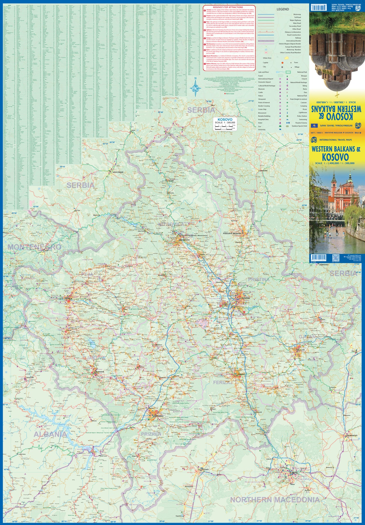
Kosovo & Western Balkans
Ordinær pris 199,00 krKosovo is the country that shouldn't exist, but does. When Yugoslavia fell to pieces after Tito died, Kosovo was lumped in with Serbia but was very unhappy with being a part of an Eastern Orthodox regime. It broke away, resulting in genocidal fighting until the Americans stepped in and stopped the fighting. The region was then placed under a European Union control in the faint hope that it would merge with Albania, or Montenegro, but it didn't. Relations with Serbia are still quite strained, but Kosovo is still surviving as a mountainous Balkan state. Fought over for centuries by Turks and Serbs, Kosovo is emerging as a small but touristic European country. This is definitely an off-the-beaten-path travel destination!
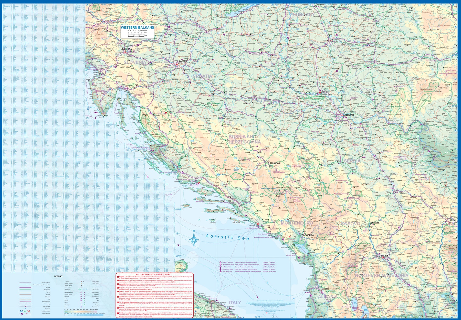
The second side of the sheet provides an excellent regional coverage for the Western Balkans, essentially Slovenia, Croatia, Montenegro, Serbia, and reasonably large tracks of land for Hungary, Albania, and North Macedonia, showing the growing number of wilderness parks being created.
Mediterranean Europe Phrasebook & Dictionary
Ordinær pris 99,00 krLonely Planet's Mediterranean Europe Phrasebook & Dictionary is your handy passport to culturally enriching travels with the most relevant and useful European phrases and vocabulary for all your travel needs. Ask for directions to the best beaches, learn about local history and culture, and navigate menus like a local - all with your trusted travel companion. With language tools in your back pocket, you can truly get to the heart of wherever you go, so begin your journey now! Get More From Your Trip with Easy-to-Find Phrases for Every Travel Situation! Order with confidence, explain food allergies, and try new foods with the menu decoder. Save time and hassles with vital phrases at your fingertips. Never get stuck for words with the 3500-word two-way, quick-reference dictionary. Be prepared for both common and emergency travel situations with practical phrases and terminology. Meet friends with conversation starter phrasesGet your message across with easy-to-use pronunciation guides Inside Lonely Planet Mediterranean Europe Phrasebook & Dictionary: Phrases to Learn Before You Go. Ways to Start a Sentence. Phrases to Sound like a Local. Listen For - phrases you may hear. Look For - phrases you may see on signs. Shortcuts - easy-to-remember alternatives to the full phrases. Q&A - suggested answers to questions asked. Covers Basics - time, dates, numbers, amounts, pronunciation, reading tips, grammar rules. Practical - travel with kids, disabled travellers, senior travellers, sightseeing, business, banking, post office, internet, phones, repairs, shopping, bargaining, accommodations, directions, border crossing, transport. Social - meeting people, interests, feelings, opinions, going out, romance, culture, activities, weather. Safe Travel - emergencies, police, doctor, chemist, dentist, symptoms, conditions. Food - ordering, at the market, at the bar, dishes, ingredients The Perfect Choice: Lonely Planet's Mediterranean Europe Phrasebook & Dictionary, our pocket-sized comprehensive language guide, provides on-the-go language assistance.
Minarets in the Mountains
Ordinær pris 169,00 krA magical, eye-opening account of a journey into a Europe that rarely makes the news and is in danger of being erased altogether. Another Europe. A Europe few people believe exists and many wish didn't.
Muslim Europe. Winner of a BGTW Members' Excellence Award: Travel Narrative Book of the Year - The Adele Evans Award. Longlisted for the Baillie Gifford Prize 2021.
Shortlisted in the Edward Stanford Travel Writing Awards 2022: Stanford Dolman Travel Book of the Year. Londoner Tharik Hussain sets off with his wife and young daughters around the Western Balkans, home to the largest indigenous Muslim population in Europe, and explores the regions of Eastern Europe where Islam has shaped places and people for more than half a millennium. Encountering blonde-haired, blue-eyed Muslims, visiting mystical Islamic lodges clinging to the side of mountains, and praying in mosques older than the Sistine Chapel, he paints a picture of a hidden Muslim Europe, a vibrant place with a breathtaking history, spellbinding culture and unique identity.
Minarets in The Mountains, the first English travel narrative by a Muslim writer on this subject, also explores the historical roots of European Islamophobia. Tharik and his family learn lessons about themselves and their own identity as Britons, Europeans and Muslims. Following in the footsteps of renowned Ottoman traveller Evliya Celebi, they remind us that Europe is as Muslim as it is Christian, Jewish or pagan.
Peaks of the Balkans
Ordinær pris 279,00 kr“The Peaks of the Balkans Trail is like a patchwork quilt of my past adventures, weaving together the best bits from trails and travels. Picture the teep, lush green hills of Thailand, challenging trails reminiscent of Corsica’s GR20, and the serene beauty of lakes and pine trees found in Norway. This trail seamlessly integrates these diverse elements, creating an unparalleled tapestry of natural wonders that rivals any scenery I’ve experienced before.” Embark on the renowned Peaks of the Balkans trail with this comprehensive yet no-nonsense guide, furnishing you with all requisite trail details! This guide encompasses: • A day-by-day itinerary of the hike • A comprehensive overview of facilities available along the route • Information on the winter route between Theth and Valbona • Comprehensive overview maps for each day’s journey • In-depth elevation profiles for every stage • Contact details for facilities along the route • A downloadable GPX file of the trail • And, naturally, other useful information.