9 produkter
9 produkter
Utsolgt
Compact World Atlas
199,00 kr

Atlas: France
Ordinær pris 349,00 kr/
Mva inkludert
Frakt beregnes i kassen.
Michelin's France Road Atlas A4 is the perfect companion for safe and enjoyable drive in France. Convenient and easy to use thanks to the spiral bound cover, Michelin France Atlas will provide you with precise and reliable information with its updated mapping scaled 1/200 000 (1 cm = 2 km). Smart and practical, this atlas includes tourist sights, leisure facilities and scenic routes recommended in the famous Michelin Green Guide as well 40 embedded city plans plus 16 with QR codes for easy access to your smartphone for online mapping and tourist information!Michelin's checklist will help you prepare your journey before your leave and Michelin's safety alerts will warn you about dangerous driving areas, such as steep hills and level crossing.
Michelin's route planner as well as the time and distance charts will help you plan and optimise your journey. Michelin's France road atlas will make sure that you make the most of your journey in France!Michelin's France tourist and motorist atlas (A4 spiral) features:* Scale 1/200 000* Spiral bound for lay-flat convenience. * Time & distance charts* Route planner with major itineraries* Tourist sights and scenic drives pulled directly from Michelin's famous Green Guide travel series using the embedded QR codes.
* Extensive place name index for rapid look-up* Location map on top of each page for an easier navigation within the atlas* 40 City maps embedded in the map of their surrounding areas with QR code to guide you through the last few miles of your journey with your smartphone plus 16 QR codes for city plans on your phone
- Publisert: 2025
- Antall sider: 294
- Innbinding: spiral
- Materiale: Papir
- Målestokk: 1:250 000

Britain & Northern Ireland
Ordinær pris 379,00 kr/
Mva inkludert
Frakt beregnes i kassen.
Freytag & Berndt veiatlas over Storbritannia og Nord-Irland.
- Publisert: 2024
- Innbinding: Spiral
- Materiale: Papir
- Målestokk: 1:200 000, 1:266 000

Caribbean Islands Atlas - West Half
Ordinær pris 169,00 kr Salgspris 84,50 kr Spar 50%/
Mva inkludert
Frakt beregnes i kassen.
Itm har kart over hele verden og de spesialiserer seg på land litt utenfor allfarvei. Beliggenheten til landets nasjonalparker, historiske monumenter, de viktigste veiene o.L. Finner du inkludert i kartene. Samtlige landkart har et bykart over hovedstaden.
1st Ed. 2013 160 pages, with a spine; scale varies The Caribbean is a particularly difficult part of the world to map effectively. It is a combination of larger islands in the west and a string of small islands in the east. Some can be shown as separate maps, but others are too small (or too lacking in market appeal) to be mapped adequately as folded paper maps. This atlas covers the Bahamas and the Turks and Caicos Islands in the north with Cuba, the Cayman Islands, Jamaica, the Dominican Republic, and Puerto Rico in scales ranging from 1:18,000 for Puerto Rico to 1:600,000 for Cuba The atlas is the same size as all ITM atlases (8 x5 or 21x13.5cm) and has a straight spine edge with title for displaying spine outwards on store shelves, if desired. Essentially, this atlas covers six different areas mapped by ITMB folded maps and adds the Turks area. Inset maps of Freeport, Nassau, Havana, Varadero, Georgetown, Kingston, Port Au Prince, Santo Domingo, and San Juan are included. The level of detail is identical with ITM s folded maps; this is a marketing concept for those wishing the convenience of information in a convenient book format, with no loss of detail.
Publisert år: 2013
sider nr: 157
Innbinding: hft
Material: papir
Målestokk: various

Reference World Atlas
Ordinær pris 449,00 kr/
Mva inkludert
Frakt beregnes i kassen.
Packed with more than 640 high-definition maps and over 950 illustrations and diagrams, this is the ultimate world atlas. Fully revised and updated edition to encompass recent world events, this extensive atlas is an invaluable reference for home, school, and office. This atlas of the world includes:- More than 640 high-definition, updated regional and world-wide maps based on the latest digital mapping and satellite data - Over 950 high-quality illustrations and diagrams- 3D terrain models that reveal physical features- Wide range of popular topics in the world from the solar system and the world's oceans, to global climate and landscape, and states and boundaries- Key geographical facts including population density, detailed infrastructure and transportation information, and time zones - A comprehensive index that contains more than 80,000 place names- Special 24-page feature section with detailed mapping of the British Isles (UK Edition)This indispensable atlas book opens with a wonderful introduction to our world with a series of maps that illustrate its physical, political, economic, and demographic geography.
As you continue to turn the pages, you'll soon discover that this atlas is unlike any other. This engaging home learning resource delivers superb cartography through beautifully designed and incredibly informative maps, diagrams and photographs to provide accurate coverage of the whole world. It also contains a wealth of fascinating facts that help give a real flavour of the geography and culture of a region.
This beautiful large-format world atlas is the perfect addition to any school or family library, or even an ideal gift for geography students!
- Publisert: April 2021
- Utgave: 11. utgave
- Innbinding: Innbundet
- Språk: Engelsk
- Antall sider: 408
- ISBN: 9780241412879

Road Atlas: USA - Canada - Mexico Large Format (A3)
Ordinær pris 189,00 kr/
Mva inkludert
Frakt beregnes i kassen.
Highlighting 51 road trips and scenic drives the Michelin's updated Large Format North America Road Atlas 2026 helps you enjoy the planning and the journey. Large-format maps and larger lettering for towns and sites (compared to the midsize atlas) make for easier reading while the tiled format flows maps from page to page—the ideal complement to GPS and online directions. Four jam-packed pages highlight selected US and Canadian national parks, with points of interest, hikes and drives.
Covers US, Canada & Mexico. Large grid map to quickly locate atlas pages. Easy-read text and mapping.
Map pages are 36% larger than midsize atlas. Inspired ideas for outdoor fun and road trip adventures in the US and Canada with four jam-packed pages highlighting selected national and provincial parks. Michelin's renowned travel guides are the resource for points of interest, hikes and scenic drives.
Tiled atlas format: user-friendly, convenient and logical to use, offering continuity when driving and providing the big picture to round out GPS and online directions. Detailed place name index to quickly pinpoint destinations and sights. 50+ large-scale city maps for navigating in and around cities.
Distance chart for major US and Canadian cities, as well as convenient city-to-city mini distance chart on each two-page map spread, for more effective trip planning. Tire tips to improve consumer driving safety.
- Publisert: Aug 2025
- Antall sider: 127
- Innbinding: Heftet
- Materiale: Papir


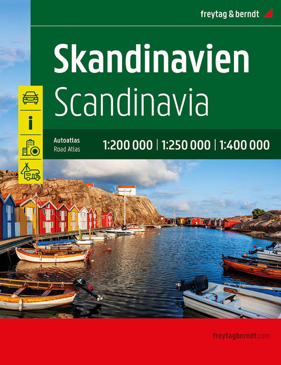
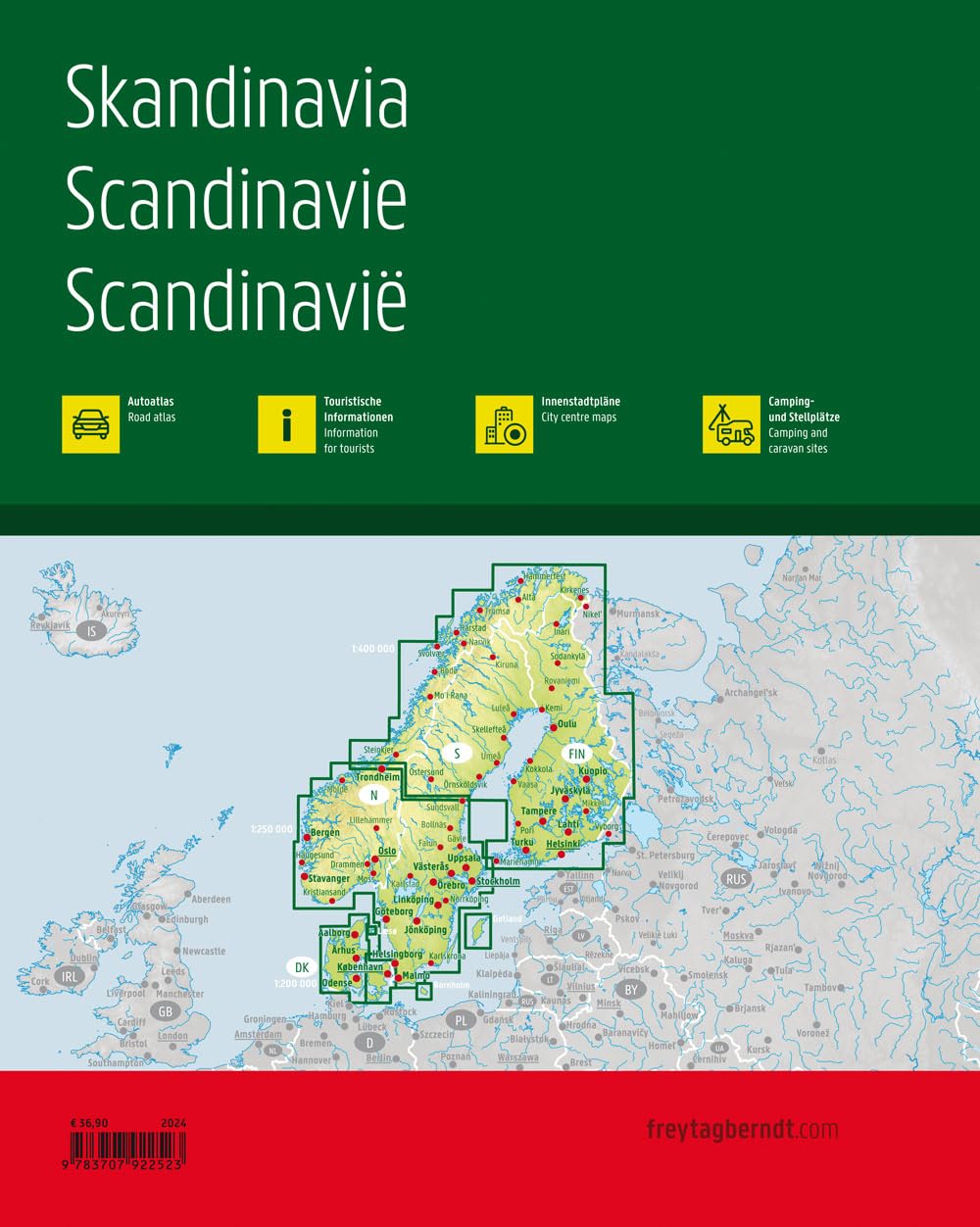
Skandinavia
Ordinær pris 499,00 kr/
Mva inkludert
Frakt beregnes i kassen.
Veiatlas over Skandinavia fra Freytag & Berndt.
- Publisert: 2024
- Innbinding: Spiral
- Materiale: Papir
- Målestokk: 1:200 000, 1:250 000, 1:400 000

Tourist & Motoring Atlas: Benelux 2024
Ordinær pris 239,00 kr/
Mva inkludert
Frakt beregnes i kassen.
Michelin Road Atlas Benelux and North of France is the perfect companion for an enjoyable and safe drive. Convenient and easy to use thanks to its spiral bound cover. Michelin Road Atlas Benelux and North of France will provide you with precise and reliable information with its mapping scaled 1/150 000 for an enjoyable journey in Northern France, Belgium, Luxembourg and Netherlands.
- Publisert: 2024
- Antall sider: 249
- Innbinding: Spiral
- Materiale: Papir
- Målestokk: 1:150 000