Filter
- Algerie
- Angola
- Benin
- Botswana
- Burundi
- Djibouti
- Egypt
- Elfenbenskysten
- Eritrea
- Eswatini
- Gabon
- Gambia
- Ghana
- Kamerun
- Kapp Verde
- Kenya
- Komorene
- Kongo
- Lesotho
- Liberia
- Libya
- Madagaskar
- Malawi
- Mali
- Mauritania
- Mauritius
- Namibia
- Niger
- Nigeria
- Rwanda
- Senegal
- Seychellene
- Sierra Leone
- Somalia
- Sudan
- Sør-Afrika
- Sør-Sudan
- Tanzania
- Tunisia
- Uganda
- Zambia
- Zimbabwe
3 produkter
3 produkter

Lonely Planet Africa
Ordinær pris 319,00 kr/
Mva inkludert
Frakt beregnes i kassen.
Lonely Planet's Africa is our most comprehensive guide that extensively covers all the continent has to offer, with recommendations for both popular and lesser-known experiences. Visit wineries on the cape, swim the turquoise waters of Mozambique and view the pyramids of Giza; all with your trusted travel companion.
- Publisert: Desember 2024
- Utgave: 15. utgave
- Antall sider: 952
- Innbinding: Heftet
- Språk: Engelsk
- ISBN: 9781787015173

Lonely Planet East Africa
Ordinær pris 329,00 kr/
Mva inkludert
Frakt beregnes i kassen.
Lonely Planet's East Africa is our most comprehensive guide that extensively covers all the country has to offer, with recommendations for both popular and lesser-known experiences. Feel the pounding of hooves as wildebeest stampede across the Serengeti; all with your trusted travel companion.
Inside Lonely Planet's East Africa Travel Guide: Lonely Planet's Top Picks - a visually inspiring collection of the destination's best experiences and where to have them. Itineraries help you build the ultimate trip based on your personal needs and interests. Local insights give you a richer, more rewarding travel experience - whether it's history, people, music, landscapes, wildlife, politics. Eating and drinking - get the most out of your gastronomic experience as we reveal the regional dishes and drinks you have to try. Toolkit - all of the planning tools for solo travellers, LGBTQIA+ travellers, family travellers and accessible travel. Colour maps and images throughout. Language - essential phrases and language tips. Insider tips to save time and money and get around like a local, avoiding crowds and trouble spots. Covers Kenya, Tanzania, Uganda, Rwanda, Burundi and more.
- Publisert: November 2023
- Utgave: 12. utgave
- Antall sider: 560
- Innbinding: Heftet
- Språk: Engelsk
- ISBN: 9781787018228


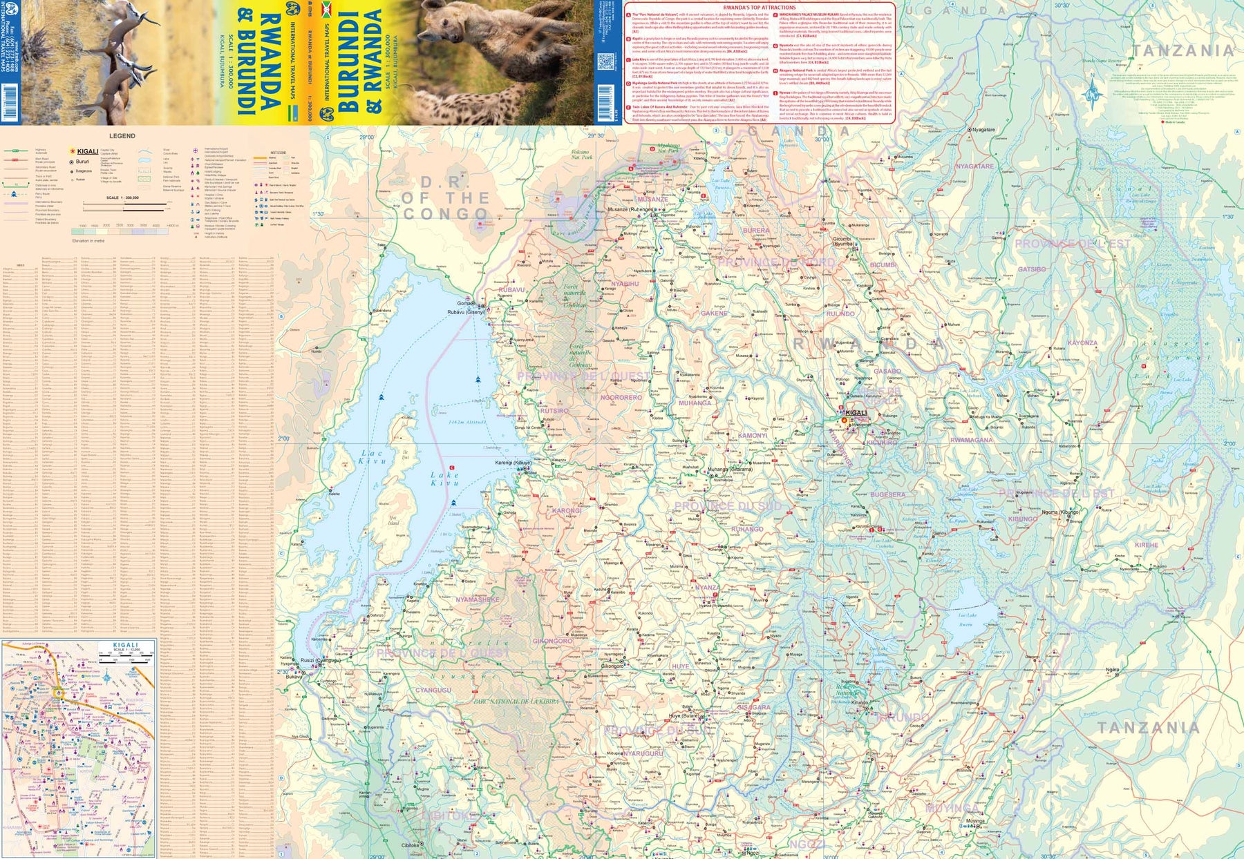
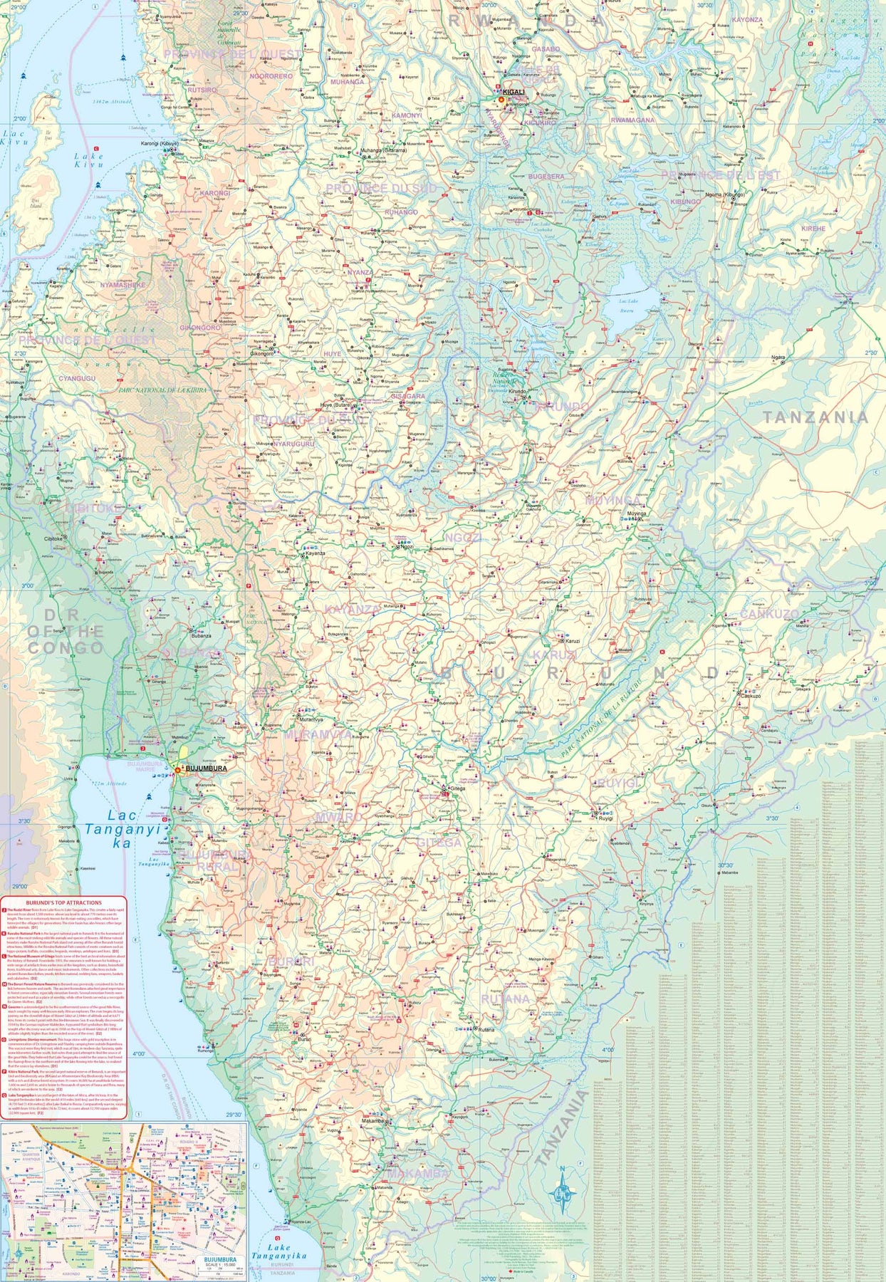
Rwanda & Burundi
Ordinær pris 199,00 kr/
Mva inkludert
Frakt beregnes i kassen.
ITM har kart over hele verden og de spesialiserer seg på land litt utenfor allfarvei. Beliggenheten til landets nasjonalparker, historiske monumenter, de viktigste veiene og lignende finner du inkludert i kartene. Samtlige landkart har ofte et bykart over hovedstaden.
- Publisert: 2023
- Innbinding: Falset
- Materiale: Papir
- Målestokk: 1:300 000