Filter
- Algerie
- Angola
- Benin
- Botswana
- Burundi
- Djibouti
- Egypt
- Elfenbenskysten
- Eritrea
- Eswatini
- Gabon
- Gambia
- Ghana
- Kamerun
- Kapp Verde
- Kenya
- Komorene
- Kongo
- Lesotho
- Liberia
- Libya
- Madagaskar
- Malawi
- Mali
- Mauritania
- Mauritius
- Namibia
- Niger
- Nigeria
- Rwanda
- Senegal
- Seychellene
- Sierra Leone
- Somalia
- Sudan
- Sør-Afrika
- Sør-Sudan
- Tanzania
- Tunisia
- Uganda
- Zambia
- Zimbabwe
4 produkter
4 produkter

Lonely Planet Africa
Ordinær pris 319,00 kr/
Mva inkludert
Frakt beregnes i kassen.
Lonely Planet's Africa is our most comprehensive guide that extensively covers all the continent has to offer, with recommendations for both popular and lesser-known experiences. Visit wineries on the cape, swim the turquoise waters of Mozambique and view the pyramids of Giza; all with your trusted travel companion.
- Publisert: Desember 2024
- Utgave: 15. utgave
- Antall sider: 952
- Innbinding: Heftet
- Språk: Engelsk
- ISBN: 9781787015173

Lonely Planet East Africa
Ordinær pris 329,00 kr/
Mva inkludert
Frakt beregnes i kassen.
Lonely Planet's East Africa is our most comprehensive guide that extensively covers all the country has to offer, with recommendations for both popular and lesser-known experiences. Feel the pounding of hooves as wildebeest stampede across the Serengeti; all with your trusted travel companion.
Inside Lonely Planet's East Africa Travel Guide: Lonely Planet's Top Picks - a visually inspiring collection of the destination's best experiences and where to have them. Itineraries help you build the ultimate trip based on your personal needs and interests. Local insights give you a richer, more rewarding travel experience - whether it's history, people, music, landscapes, wildlife, politics. Eating and drinking - get the most out of your gastronomic experience as we reveal the regional dishes and drinks you have to try. Toolkit - all of the planning tools for solo travellers, LGBTQIA+ travellers, family travellers and accessible travel. Colour maps and images throughout. Language - essential phrases and language tips. Insider tips to save time and money and get around like a local, avoiding crowds and trouble spots. Covers Kenya, Tanzania, Uganda, Rwanda, Burundi and more.
- Publisert: November 2023
- Utgave: 12. utgave
- Antall sider: 560
- Innbinding: Heftet
- Språk: Engelsk
- ISBN: 9781787018228


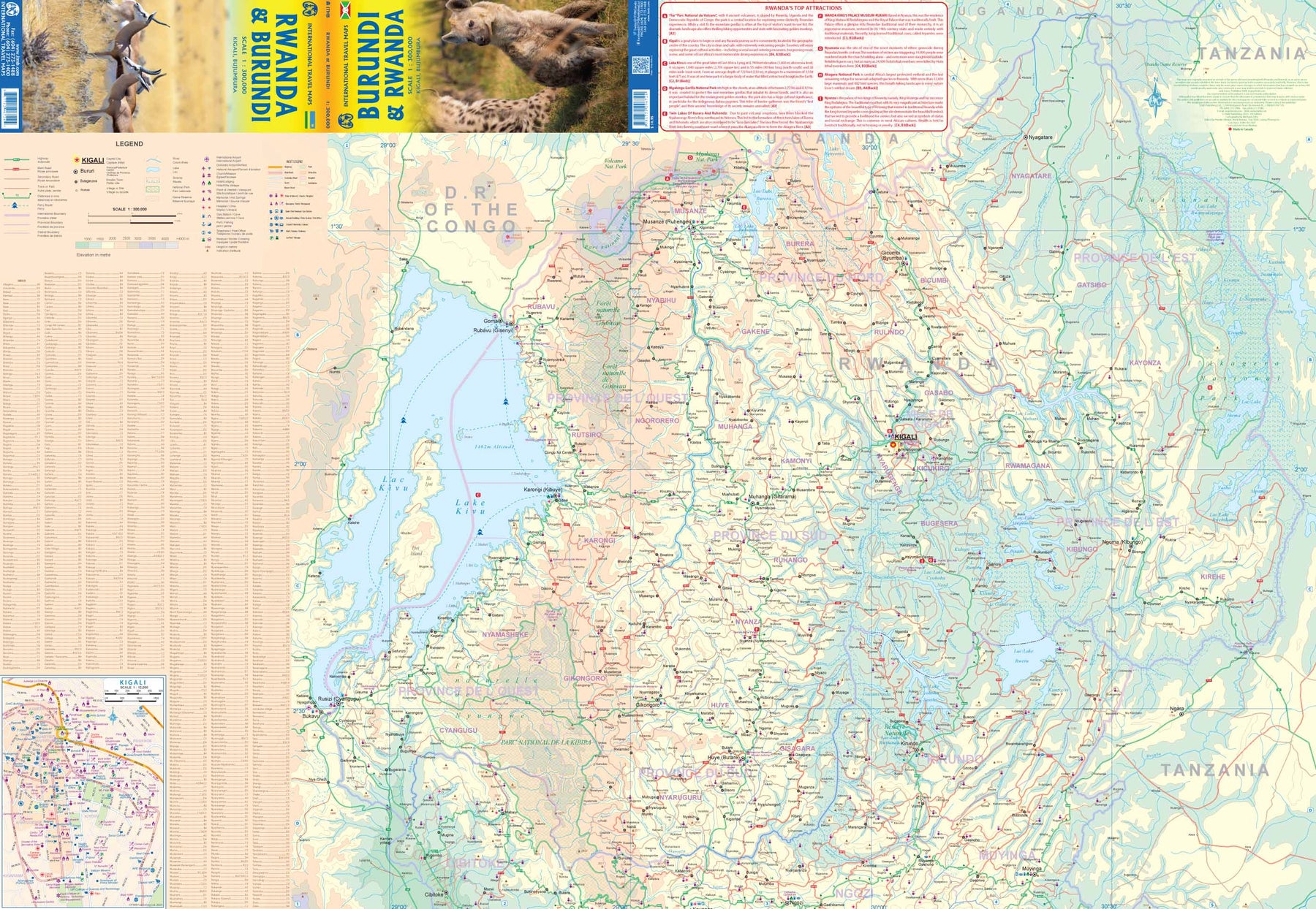
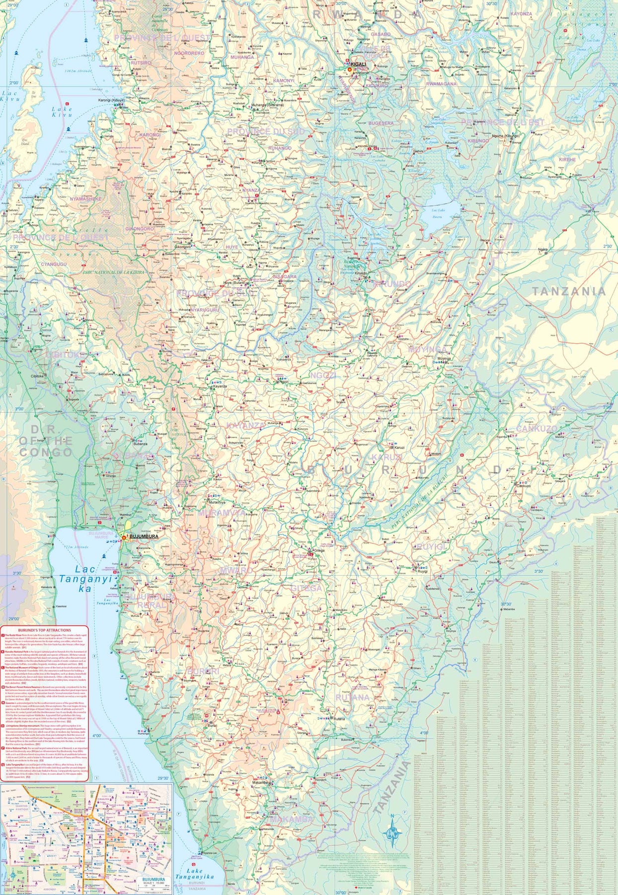
Rwanda & Burundi
Ordinær pris 199,00 kr/
Mva inkludert
Frakt beregnes i kassen.
ITM har kart over hele verden og de spesialiserer seg på land litt utenfor allfarvei. Beliggenheten til landets nasjonalparker, historiske monumenter, de viktigste veiene og lignende finner du inkludert i kartene. Samtlige landkart har ofte et bykart over hovedstaden.
- Publisert: 2023
- Innbinding: Falset
- Materiale: Papir
- Målestokk: 1:300 000

Rwanda (With Eastern Congo)
Ordinær pris 319,00 kr/
Mva inkludert
Frakt beregnes i kassen.
Now into its eighth edition and written by Philip Briggs, the world's leading author of African guidebooks, Bradt's Rwanda has been the go-to guide for visitors to the 'Land of a Thousand Hills' for more than 20 years. Still the only standalone guide in English to this increasingly popular destination, it remains in a class of its own for in-depth information. With fresh research into developments across the country, Bradt's Rwanda includes expanded coverage of Gishwati-Mukura National Park, which opened to tourism in 2021, and up-to-date details of rapidly modernising Kigali, considered Africa's cleanest city.
Rwanda continues to change and develop at an unprecedented pace - no country has a higher proportion of female parliamentarians - and there's hardly a more accessible part of Africa. It's no less intriguing for the convenience, however, and Rwanda's superlative natural attractions constantly improve, with growing animal populations, as in Akagera National Park, where Africa's Big Five (rhino, lion, leopard, elephant and buffalo) can be seen. This new edition also includes extensive maps and natural history information, while details of kayak and canoe excursions on Lake Kivu and the Mukungwa River complement advice about staying on tea plantations at Sorwathe or Gisovu.
It contains everything you need to know about tracking mountain gorillas in Volcanoes National Park (workplace of primatologist Dian Fossey of Gorillas in the Mist fame) and chimpanzees in Nyungwe National Park (East Africa's largest surviving montane forest, harbouring numerous endemic birds and primates) and Gishwati-Mukura (which is also the only location for the rare golden monkey outside the Virunga mountains). Also covered are Nyanza, with its hilltop Rukari King's Palace Museum, and the Ethnographic Museum of Rwanda, the top cultural site in Butare (Huye). A chapter on nearby cities and national parks provides key necessary information to take an excursion into neighbouring DRC, including how to see lowland gorillas.
It's no less intriguing for the convenience, however, and Rwanda's superlative natural attractions seem to improve by the day, with growing animal populations and an on-going rhino reintroduction program in Akagera National Park. Having now gone through nearly 18 years of editions, Bradt's Rwanda is not only the most in-depth guide available, but also the guide with the longest history in the country itself.
- Forfatter: Philip Briggs
- Publisert: Des. 2023
- Utgave: 8. utgave
- Antall sider: 336
- Innbinding: Heftet
- ISBN: 9781804690161