Filter
- AA Publishing
- Assouline
- Authentic Models BV
- Borch
- Bradt
- Cabeau
- Calazo
- Cappelen Damm
- Care Plus
- Cicerone
- Colgate
- Columbus Globes
- Craghoppers
- Dapa Maps
- Discovery Walking Guides
- Dr. Bronner
- Eagle Creek
- Editorial Alpina
- Esterbauer Verlag
- ExpressMap
- Eyewitness
- Filson
- Fodor's
- Freytag & Berndt
- Gentlemen's Hardware
- Go Travel
- Hydro Flask
- Insight Guides
- ITM
- Kastel
- Ledlenser
- Lifeventure
- Lonely Planet
- Luster Publishing
- National Geographic
- Nordeca
- Ordnance Survey
- Osprey
- Patagonia
- PopOut
- Reise Know-How
- Rother Walking Guide
- Rough Guides
- Thames & Hudson
- The Urban Explorer
- Tilley
- Touring Club Italiano
- Trailblazer
- Afghanistan
- Albania
- Algerie
- Andorra
- Angola
- Antigua og Barbuda
- Argentina
- Armenia
- Aserbajdsjan
- Australia
- Bahamas
- Bahrain
- Bangladesh
- Barbados
- Belgia
- Belize
- Benin
- Bhutan
- Bolivia
- Bosnia-Hercegovina
- Botswana
- Brasil
- Brunei
- Bulgaria
- Burundi
- Canada
- Chile
- Colombia
- Cookøyene
- Costa Rica
- Cuba
- Danmark
- De forente arabiske emirater
- Djibouti
- Dominica
- Ecuador
- Egypt
- El Salvador
- Elfenbenskysten
- Eritrea
- Estland
- Eswatini
- Etiopia
- Fiji
- Filippinene
- Finland
- Frankrike
- Gabon
- Gambia
- Georgia
- Ghana
- Grenada
- Guatemala
- Guyana
- Haiti
- Hellas
- Honduras
- Hviterussland
- India
- Indonesia
- Irak
- Iran
- Irland
- Island
- Israel
- Italia
- Jamaica
- Japan
- Jemen
- Jordan
- Kambodsja
- Kamerun
- Kapp Verde
- Kasakhstan
- Kenya
- Kina
- Kirgisistan
- Komorene
- Kongo
- Kosovo
- Kroatia
- Kuwait
- Kypros
- Laos
- Latvia
- Lesotho
- Libanon
- Liberia
- Libya
- Liechtenstein
- Litauen
- Luxembourg
- Madagaskar
- Malawi
- Malaysia
- Maldivene
- Mali
- Malta
- Marokko
- Mauritania
- Mauritius
- Mexico
- Moldova
- Monaco
- Mongolia
- Montenegro
- Mosambik
- Namibia
- Nauru
- Nederland
- Nepal
- New Zealand
- Nicaragua
- Niger
- Nigeria
- Nord-Korea
- Nord-Makedonia
- Norge
- Oman
- Pakistan
- Palau
- Palestina
- Panama
- Papua Ny-Guinea
- Paraguay
- Peru
- Polen
- Portugal
- Qatar
- Romania
- Russland
- Rwanda
- Saint Kitts og Nevis
- Saint Lucia
- Saint Vincent og Grenadinene
- Samoa
- San Marino
- Saudi-Arabia
- Senegal
- Serbia
- Seychellene
- Sierra Leone
- Singapore
- Slovakia
- Slovenia
- Solomonøyene
- Somalia
- Spania
- Sri Lanka
- Storbritannia
- Sudan
- Surinam
- Sveits
- Sverige
- Syria
- Sør-Afrika
- Sør-Korea
- Sør-Sudan
- Tadsjikistan
- Taiwan
- Tanzania
- Thailand
- Togo
- Tonga
- Trinidad og Tobago
- Tsjekkia
- Tunisia
- Turkmenistan
- Tuvalu
- Tyrkia
- Tyskland
- Uganda
- Ukraina
- Ungarn
- Uruguay
- USA
- Usbekistan
- Vanuatu
- Venezuela
- Vietnam
- Zambia
- Zimbabwe
- Øst-Timor
- Østerrike
2600 produkter
2600 produkter

Greece: Chalkidiki; Thasos & Thessaloniki
Ordinær pris 189,00 kr/
Mva inkludert
Frakt beregnes i kassen.
Dette store østerriske kartforlaget er kjent for sin klare kartografi og gode papirkvalitet. De kommer i alle målestokker, og flere av landkartene inneholder bykart og turistinformasjon.
The Chalkidiki (Halkidiki) Peninsula and Thasos in northern Greece on a large, indexed road map at 1:150,000 from Freytag & Berndt, with coverage extending south to include Katerini and Mount Olympus (Olympos), a street plan of central Thessaloniki and a booklet with brief descriptions of the region’s 10 best sights.
All place names are given in both Latin and Greek alphabet.
Topography is shown by relief shading, with spot heights and colouring for the forested areas. Road network emphasizes main roads, but also shows small local roads, many with driving distances. Scenic routes are highlighted. Railway lines and ferry routes are included and domestic airports are marked. Symbols indicate various places of interest, including numerous monasteries on the Mount Athos peninsula, and the region’s 10 best sights are prominently highlighted and given brief descriptions in the multilingual booklet attached to the map cover. The map has latitude and longitude lines at intervals of 10’. The index is in the booklet. Map legend and the descriptions include English.
Also provided is a street plan of central Thessaloniki. Larger streets are in both scripts; smaller streets and names of important buildings are in the Latin alphabet only.
Publisert år: 2022
Innbinding: falset
Material: papir
Målestokk: 1:150000

Greece: Corfu
Ordinær pris 169,00 kr/
Mva inkludert
Frakt beregnes i kassen.
Tysk kartserie med flotte kart på slitesterkt plastpapir.
Reise Know-How maps (world mapping project series) are easy-to-read, waterproof and highly durable travel maps specifically designed for everyday use on the road.
The maps combine state-of-the-art, GPS-compatible cartography (including hypsometric tints and contour lines) with a detailed rendering of road networks and touristic information. They offer the best possible scale, level of detail and readability, be it a map of a small island or half a continent.
The maps feature a detachable paper sleeve so that the maps can be folded easily and fit in every pocket. Although printed on plastic, a special coating makes sure the maps retain a paper-like feel and can even be written on with a pencil.
- Publisert: 2019
- Innbinding: Falset
- Materiale: Plastpapir
- Målestokk: 1:65 000

Greece: Crete (Kreta)
Ordinær pris 199,00 kr/
Mva inkludert
Frakt beregnes i kassen.
Crete at 1:140,000 on a clear, indexed map with topographic and tourist information, printed on light, waterproof and tear-resistant plastic paper. The map, published by Reise Know-How as part of their highly acclaimed World Mapping Project, divides the island east/west with an overlap between the sides. Topography is shown by altitude colouring with contours and numerous spot heights, plus names of various geographical features. Road network shows local roads and tracks, gives driving distances on main and secondary roads. Ferry routes are also marked.
The map highlights various places of interest including churches and monasteries, archaeological sites, beaches, view points, etc. Names of towns and villages are given in both Greek and Latin alphabets; geographical features and places of interest are in the Latin alphabet only. The map is indexed and has latitude and longitude grid at intervals of 10’. Map legend includes English.
- Publisert: 2022
- Innbinding: Falset
- Materiale: Plastpapir
- Målestokk: 1:140 000

Greece: Crete; Mykonos & Santorini
Ordinær pris 169,00 kr/
Mva inkludert
Frakt beregnes i kassen.
The many islands off the coast of Greece can only be mapped properly a few at a time. Side 1 of this map shows the large island of Crete in good detail, with the relatively nearby island of Mykonos and its adjacent island of Rinia and the island of Santorini, with its adjacent islands of Thirasia and Nea Kameni being shown in great detail. A locality map showing the islands in relation to the rest of Greece is included as an inset. It is our intention to map more islands as time passes, but this depends upon future research trips (we lead a hard life!).
Side 2 of the map is a general map of Greece in relation to its neighbours to the north and east. The Mediterranean is divided into smaller seas, such as the Adriatic along the coast of Croatia, the Ionian to the west of Greece, the Myrtoan to its south and the Aegean to its east. All this area is replete with islands and geopolitical conflicts. As such, this map is useful for showing the region as an entity that links the Balkan states to the eastern Mediterranean.
- Publisert: 2023
- Innbinding: Falset
- Materiale: VanntettPapir
- Målestokk: 1:265,000 / 1:70,000

Greece: Lesbos (lesvos)
Ordinær pris 189,00 kr Salgspris 94,50 kr Spar 50%/
Mva inkludert
Frakt beregnes i kassen.
Dette store østerriske kartforlaget er kjent for sin klare kartografi og gode papirkvalitet. De kommer i alle målestokker, og flere av landkartene inneholder bykart og turistinformasjon.
Lesbos at 1:50,000 on an indexed, GPS compatible map from Freytag & Berndt with brief descriptions of places of interest highlighted on the map, plus a street plan of Mitilini. The map is double-sided, dividing the island east/west, with a very generous overlap between the sides.
Topography of the island is shown by bold relief shading, enhanced by contours at 40m intervals. All place names are given in both Greek and Latin alphabet. Road network includes small local roads and selected cart tracks, showing driving distances on main and secondary routes. Ferry connections are marked.
The island’s best sights are prominently highlighted and provided with brief multilingual descriptions in a booklet attached to the map cover. Various other places of interest are marked and named on the map, including numerous beaches and churches/monasteries.
The map has a UTM grid, plus latitude and longitude margin ticks. The index, placed in the booklet, provides GPS waypoints for all the locations listed in it. Multilingual map legend includes English.
Publisert år: 2018
Innbinding: falset
Material: papir
Målestokk: 1:50000

Greece: Northern
Ordinær pris 249,00 kr/
Mva inkludert
Frakt beregnes i kassen.
This new guide to Northern Greece, written by Greece expert and long-time travel writer Dana Facaros, is the only guide available to the region and includes the areas of Epirus, Thessaly, Macedonia and Thrace, complete with their five dramatically beautiful national parks, the country's highest peaks and mountain lakes, rushing rivers and the world's deepest gorge, and (this is Greece, after all) long sandy beaches. Sections on background and practical information are followed by an easy-to-follow breakdown of the area offering detailed coverage in 12 chapters, from Greece's second city, Thessaloniki, to Chalkidiki, Central Macedonia, Eastern Macedonia, Thrace, Western Macedonia, Epirus (including Ioannina), Thessaly and Magnesia, the Pelion Peninsula and the Islands, plus a short chapter on Athens, the gateway for many visitors to Greece. Greece is becoming more popular by the year and this area in particular offers the more natural, authentic experience that many travellers seek.
Bradt's Northern Greece focuses on just this relatively unknown but up-and-coming region and is an ideal companion for travellers of all ages, budgets and interests, from culture lovers to wildlife enthusiasts, history buffs to archaeologists, foodies to wine connoisseurs. Holidays in the great outdoors are covered, too, including mountain climbing, skiing, white water rafting, rock climbing, sailing, canyoning and sea kayaking, not to mention those who just want to sit on a sandy beach and dance the night away.
- Forfatter: Dana Facaros
- Publisert: Januar 2020
- Utgave: 1. utgave
- Antall sider: 384
- Innbinding: Heftet
- Språk: Engelsk
- ISBN: 9781784776312

Greece: Southern Peloponnese
Ordinær pris 299,00 kr/
Mva inkludert
Frakt beregnes i kassen.
The go-to Southern Peloponnese travel guide for discovering the best walks and car tours. Strap on your boots and discover the Southern Peloponnese on foot with the Sunflower Southern Peloponnese travel guide. And on the days when your feet may have had enough, enjoy some spectacular scenery on one of our legendary car tours.
The Sunflower Southern Peloponnese guide is indispensable for hiking in the Peloponnese or seeing the Peloponnese by car. There are hidden landscapes throughout mainland Greece, but the region which packs the most variety into the smallest space is the Peloponnese. From the beaches of Arcadia to the fir forests of Mt Parnon, from the olive groves of Kalamata to the pyramidal peak of Prophet Elijah, from classical Sparta to medieval Mani, this compact semi-island has it all.
Though the ancients called it 'the island of Pelops', after their mythical king, this three-fingered landmass is joined to the mainland by a narrow isthmus at Corinth. Only in the 19th century was a canal finally cut through the isthmus, but it retains the cultural diversity and spectacular scenery of the mainland. Because there's so much to discover, the author has drawn an east-west line roughly through the middle of the Peloponnese, and limited the book to the southern half.
- Publisert: 2019
- Utgave: 3. utgave
- Antall sider: 152
- Innbinding: Heftet
- Språk: Engelsk
- ISBN: 9781856915281

Green Britain & Northern Ireland
Ordinær pris 159,00 kr/
Mva inkludert
Frakt beregnes i kassen.
Glimrende bakgrunnstoff, få bilder og gode kart kjennetegner Rough Guides. Dette er en av de mest populære guidebokseriene, beregnet for folk som reiser på egenhånd. Fyldige men ikke avskrekkende, verken i pris eller størrelse. Her finner du informasjon av praktisk og kuriøs karakter, skrevet av engasjerte og kunnskapsrike forfattere. Anbefales spesielt for europeiske reisemål, ettersom serien har lengst erfaring fra dette kontinentet.
- Publisert: 2021
- Utgave: 1. utgave
- Antall sider: 136
- Innbinding: Heftet
- Språk: Engelsk
- ISBN: 9781839057557

Greenland & Arctic Circle Trail
Ordinær pris 349,00 kr/
Mva inkludert
Frakt beregnes i kassen.
At just over 100 miles long, and taking 7 to 10 days to complete, the Arctic Circle Trail crosses the largest ice-free patch of West Greenland. This splendid trekking route, lying 25-30 miles north of the Arctic Circle runs from Kangerlussuaq to Sisimiut (both of which have airport access). The trail traverses remote, empty, silent and stunningly scenic arctic tundra, and is mostly gently graded with just a few short, steep and rocky slopes. However, the landscape between the two towns of Kangerlussuaq and Sisimiut is extremely remote and those who choose to take on this route must be competely self-sufficient.
The book includes plenty of practical information on what to take with you and when to go, as well as on safety, travel and accommodation. Fully illustrated with a variety of photographs and its route is highlighted on continuous trekking maps. The guide also includes an optional extension to the Greenlandic ice cap.
- Publisert: 2023
- Antall sider: 136
- Innbinding: Heftet
- Språk: Engelsk
- ISBN: 9781852849672

Grenada, Carriacou & Petit Martinique
Ordinær pris 299,00 kr/
Mva inkludert
Frakt beregnes i kassen.
Written by Caribbean-based writer, publisher and photographer Paul Crask, this new, thoroughly updated fourth edition of Bradt's Grenada, Carriacou and Petite Martinique remains the only standalone guide to this alluring Caribbean-island destination. With insider knowledge gleaned from 15-plus years' exploration, Bradt's guidebook is rich in detail, local colour and practical information. Detailed listings covering accommodation (from homestays to top-range boutique hotels), dining and activities (including off-the-beaten-path experiences) are complemented by the author's personal take on making the most of your stay.
Grenada is an English-speaking tri-island nation famed for its nutmeg and cocoa, sailing regattas attracting international crowds, jaw-dropping beaches, pastoral villages, mountain trails, fabulous scuba diving including an underwater sculpture gallery, and strong cultural traditions including carnival parades. The main island, Grenada, has a tall spine of forested mountain ridges surrounded by rivers, waterfalls and farmlands, and the scenic coastline is replete with secluded bays and anchorages. To the north lie the tranquil islands of Carriacou and Petite Martinique, which harbour deserted beaches and coral reefs, boast traditions of Big Drum Dance and boat building, and offer a warm, friendly welcome.
This new edition incorporates the many developments on the islands over recent years. These include an increasingly impressive diversity of accommodation options resulting from ongoing investment, including a new resort on Grenada's Grand Anse Beach, which complement the more traditional feel maintained in the north of the island and its smaller neighbours. Also featured is Grenada's renewed focus on hiking trails, an addition to Grenada's already fascinating chocolate industry.
Visiting this year-round destination is increasingly easy thanks to ever-more frequent, direct flights from North America and Europe. With ample great accommodation and dining options, Grenada perfectly blends traditional island life with modern Caribbean living. Whether you are into yachting, scuba diving on wrecks and reefs, kayaking through mangrove forests, hiking mountain trails, 'jumping-up' at carnival, sampling vintage rums at historic distilleries, exploring historic estates, or relaxing poolside at luxurious beachside resorts, Bradt's Grenada, Carriacou and Petite Martinique is ideal for travellers of all kinds.
- Forfatter: Paul Crask
- Publisert: Apr 2023
- Utgave: 4. utgave
- Antall sider: 240
- Innbinding: Heftet
- Språk: Engelsk
- ISBN: 9781784779443


Grind 2.0 – Brun skinnhanske
Ordinær pris 749,00 kr/
Mva inkludert
Frakt beregnes i kassen.
Revirs skinnhanske Grind 2.0 i brun – en robust klassiker for arbeid og hverdagsbruk
Vår skinnhanske Grind 2.0 i brun er vår mer tradisjonelle og robuste versjon av den klassiske «driver-hansken». Sammenlignet med den gule varianten, oppleves denne hansken som litt tykkere i skinnet, da den ikke gjennomgår samme behandling som de gule. Perfekt for deg som ønsker en solid og pålitelig hanske, enten du er i byen, på bygda, eller kledd i frakk og dress.
Bruksområder
Denne hansken er laget for alt fra saueklipping til vedstabling og blir raskt en uunnværlig følgesvenn til både arbeid og utendørsaktiviteter. Enten du trenger en hanske for praktisk bruk eller som en stilfull hverdagsdetalj, vil Grind 2.0 levere
Vedlikehold
For å sikre lang levetid og økt vannavvisning, bør hanskene settes inn med grease, voks eller annen egnet skinnbehandling. Dette gir også bedre komfort, spesielt i fuktige forhold.
Passform
Se størrelsesguiden i bildegalleriet for å finne riktig størrelse. Hanskene kan gjerne sitte litt tett fra starten av, da de vil forme seg etter hånden din over tid. Målet er en hanske som fungerer som et ekstra hudlag, for optimal følelse og presisjon.
Tilleggsutstyr
For kaldere dager har vi utviklet en tynn liner i merinoull, kalt «Grom». Denne ble lansert i 2023 og er spesielt designet for å passe inni Grind-hansken, slik at du kan bruke den året rundt.
Grind 2.0 i brun – stil, funksjonalitet og holdbarhet i én og samme hanske.


Grind 2.0 – Gul skinnhanske
Ordinær pris 749,00 kr/
Mva inkludert
Frakt beregnes i kassen.
Revirs Grind 2.0 er en real, svært slitesterk arbeidshanske bygget rundt den klassiske amerikanske «driver»-hansken. Ikke driver som i sjåfør, men som i ridende kveg-gjeter, cattle driver, eller cowboy om du vil.
Hansken brukes til alt fra saueklipping til vedstabling og er en følgesvenn du blir usedvanlig glad i til alt av arbeid og turer utendørs!
Den er laget i 100% lett farget kuskinn som ser bra ut i utgangspunktet, men som gjennom hard bruk utvikler en nydelig patina.
Hanskene bør settes inn med grease, voks eller annen egnet skinnbehandling for økt vannavvisning og komfort.
Se størrelsesguide i bildegalleriet. Hansken må gjerne sitte litt «akkurat» fra starten av – siden den former seg på klypa etter hvert – og det tross alt skal fungere som et ekstra lag med hud slik at du har litt fingerspitzgefühl.
I ettertid har vi sett behovet for å designe et tynn liner i merinoull som kan brukes inni Grind-hansken når det er kaldt ute og i 2023 var innerhansken «Grom» endelig på plass i butikken.


Grønland 1921
Ordinær pris 1.100,00 kr/
Mva inkludert
Frakt beregnes i kassen.
Dette kartet er kun tilgjengelig for kjøp i nettbutikken. Kartet printes når du kjøper, og har derfor noe lengre leveringstid.
Dette er Dapa Maps' utsnitt over deler av Grønland fra kartet Kristiania 1921.
Oslos peneste kart? Ja det mener vi. I flere år har Dapa Maps sett på dette kartet og tenkt at de må gjøre med det. Vinteren 2023/2024 har de gjort en digital restaurering av kartet og kan nå vise det frem for allmenheten.
Kartet er opprinnelig tegnet av Byens Oppmaalingsvesen (forløper til Plan- og bygningsetaten) i 1921. Kartet ble da tegnet på 6 ulike kartblad som finnes arkivert hos Byarkivet.
Det Dapa Maps har gjort er å sette kartet sammen til et kart og redigert bort rutenettet slik at lesbarheten blir bedre. De har ikke endret noe på fargene eller på noen andre detaljer.
Dapa Maps
Kartet er laget av Daniel og Pavel fra Dapa Maps. De er to kartografer som tror at livet er best ute, derfor er de opptatt av å lage de peneste kartene de kan for at du kan bli kjent med områdene du liker best. Om du ønsker kan du lese mer om de her.
For hvert kart som selges planter de et tre slik at verden blir litt grønnere 🌳
Ramme og montering
Dapa Maps har endelig funnet frem til den perfekte rammen og kan nå tilby ramme og montering av kartet.
- Massiv eik
- Glass
- Enkelt å bytte ut kartet
- Mulighet for å henge den både stående og liggende
- 50 x 70 cm (samme som alle Dapas kart)

Guam & West Pacific Cruising
Ordinær pris 169,00 kr/
Mva inkludert
Frakt beregnes i kassen.
We are very pleased to be (finally) able to publish the first travel map of the island of Guam. Certainly, this is the only map of Guam by any major cartographic publishing house. Here are some details: Guam is a north-south island considerably north of New Guinea, and forms part of the American-held group of islands known as the Northern Marianas. Its capital is Hagatna, and the main town is called Tamuning. The island has a well-developed international airport in the middle portion of the island, with a large US military airbase in the northeast corner. The vast majority of the island is touristic, and well worth a visit. The island was "discovered" by Ferdinand Magellan in 1521, and Hagatna is the oldest "European" city in the Pacific, dating from 1686. The town of Inarajan retains a decidedly Spanish appearance to this day. Other attractions include Tumon Beach and its many resorts, the Piti Underwater Observatory, and the famous Cocos Island dive wall.
This is a double-sided map, with the Western Pacific Cruising map gracing the second side of the page. This side covers several island entities, and stretches from Australia in the south to Japan in the north and as far to the east as Hawaii and the Cook Islands, so includes such popular cruise destinations as Fiji, Tonga, New Caledonia, the Solomons, Papua, Samoa, Kiribati, and the Marshall Islands. It makes a lovely wall map!
- Publisert: 2022
- Innbinding: Falset
- Materiale: Papir
- Målestokk: 1:55 000/1:12 000 000

Guatemala & Belize
Ordinær pris 239,00 kr/
Mva inkludert
Frakt beregnes i kassen.
Reise Know-How maps (world mapping project series) are easy-to-read, waterproof and highly durable travel maps specifically designed for everyday use on the road. Our maps combine state-of-the-art, GPS-compatible cartography (including hypsometric tints and contour lines) with a detailed rendering of road networks and touristic information. They offer the best possible scale, level of detail and readability, be it a map of a small island or half a continent.
The maps feature a detachable paper sleeve so that the maps can be folded easily and fit in every pocket. Although printed on plastic, a special coating makes sure the maps retain a paper-like feel and can even be written on with a pencil.
- Publisert: 2024
- Innbinding: Falset
- Materiale: Plastpapir
- Målestokk: 1:500 000

Guyana
Ordinær pris 299,00 kr/
Mva inkludert
Frakt beregnes i kassen.
This new third edition of Bradt's Guyana remains the only guidebook available to this South American gem, a jungle-clad country teeming with exotic wildlife. Thoroughly researched, easy to use and interesting to read, Bradt's Guyana is written and updated by writers who have lived in and promoted Guyana for many years and is an ideal companion for all travellers, from wildlife watchers to fishermen, anthropologists to conservationists and 'voluntourists'. Guyana is a destination on the rise, described - justifiably - by the tourist board as 'South America Undiscovered'.
This new edition of Bradt's Guyana has been updated to include all the latest developments, ranging from how to see harpy eagles at Warapoka to new culinary experiences, local tour operators, 4x4 self-drive and new hotels. Truly off the beaten track, Guyana is one of the most fascinating and least-known countries in the Americas. It is also the only English-speaking country in South America.
The jewel in its crown is the mouth-droppingly beautiful Kaieteur Falls, which is nearly five times the height of Niagara and the world's tallest single-drop waterfall. Culturally Caribbean, its capital Georgetown is a curious melting-pot of quaint Dutch and British colonial architecture, steel drums, boisterous nightlife, rum shops with world-class rum, cricket and tropical sea breezes. It is also the gateway to the lush interior which is full to the brim with fascinating flora and fauna including monkeys, black caiman, harpy eagles, giant anteaters, otters and the mighty jaguar.
With Bradt's Guyana, discover all of this, plus where to stay in community lodges and see the rainforest through the eyes of Amerindian guides, where to watch turtles nesting on the beach, how to explore the moody Essequibo river (the largest between the Orinoco and the Amazon), and how to visit the million-acre rainforest reserve of Iwokrama for the ultimate authentic wildlife experience. This third edition of Bradt's Guyana is the key book to plan an expedition into its densely forested lush interior, often accessible only by boat or small aircraft, before taking some 'time to lime' in a hammock in one of its tropical waterfront resorts.
- Forfatter: Kirk Smock
- Publisert: Juni 2018
- Utgave: 3. utgave
- Antall sider: 324
- Innbinding: Heftet
- Språk: Engelsk
- ISBN: 9781841629292

Guyana; Suriname & French Guiana
Ordinær pris 169,00 kr/
Mva inkludert
Frakt beregnes i kassen.
Tysk kartserie med flotte kart på slitesterkt plastpapir.
Guyana, Suriname and French Guiana at 1:1,850,000on an indexed, waterproof and tear-resistant road map with topographic and tourist information, published by Reise Know-How as part of their highly acclaimed World Mapping Project. The map is double-sided to provide the best balance between a good scale and a convenient size sheet. The whole of Guyana is on one side, with Suriname and French Guiana on the reverse; disputed border areas are clearly marked.
Light altitude colouring with names of mountain ranges and peaks, plus spot heights, presents the topography. National parks and other protected area are highlighted. Road network includes unpaved, seasonal tracks. Distances are marked on main and secondary roads. and locations of petrol stations and border crossings are indicated. Symbols show various place of interest, including UNESCO World Heritage sites, beaches, etc. Also shown are internal administrative boundaries with names of the provinces. The map has a grid with latitude and longitude at intervals of 1º and an index of localities which lists national parks and nature reserves separately. Map legend includes English.
Publisert år: 2014
Innbinding: falset
Material: Plastpapir
Målestokk: 850000

Haiti
Ordinær pris 269,00 kr/
Mva inkludert
Frakt beregnes i kassen.
Bradt travel guides er et engelsk forlag med over 200 titler som I hovedsak er skrevet for turister som bruker offentlige transportmidler og egne ben. Bradt har vunnet mange priser for reisehåndbøkene sine som er kjent for å være sterke på mindre kjente reisemål som ikke er overfylt av turister. Forfatterne sørger gjerne for å gi bøkene en personlig ”touch”, og er ikke redde for å være subjektive. Dette gjør dem både til tider morsomme I tillegg til å være informative og enkle å lese. Bradt travel guides var svært tidlig ute med fokus på viktige emner som øko-turisme og den reisendes ansvar som gjest I et fremmed land. Reisehåndbøkene gir råd til hvordan man best kan nyte en eventyrlig reise borte fra turisthordene samtidig som man gjør det mulig for lokale samfunn og natur å dra nytte av besøket. Bradt guides er guidebøkene til mindre kjente reisemål du ikke vil finne hos andre utgivere. De er gode følgesvenner for eventyrlystne med ryggsekk på et gjennomsnittlig budsjett. Bradt-serien highlights er ideell for deg som planlegger for en gruppe/familie og som sikter på å få mest mulig ut av reisen. Bøkene er skrevet I samarbeid med gode turoperatører og gir en snarvei I planleggingsprosessen til en reise uten trøbbel. I tillegg har bradt har også titler med særlig fokus på plante- og dyreliv, alle med ordet wildlife som en del av tittelen. To mindre og gode bradt-serier er eccentric som fokuserer på det sprø, morsomme og andreldes destinasjoner og slow guides med forslag til båt-, vandre- og sykkelturer I storbritannia.
forfattere: Paul clammer
Publisert måned: Nov
Publisert år: 2016
Utgave: 2.utg
Sider nr: 232

Hampshire & Isle of Wight
Ordinær pris 129,00 kr/
Mva inkludert
Frakt beregnes i kassen.
Explore Hampshire and Isle of Wight by bike with this laminated, waterproof Hampshire and Isle of Wight map. With 12 circular, clearly-marked routes this easy-to-use map will help you discover the best of Hampshire and Isle of Wight along the quietest country lanes. Hampshire and Isle of Wight is blessed with some stunning countryside and a gorgeous coastline ideal for exploring by bike.
Discover some wonderful winding lanes that connect beautiful villages with excellent pubs and friendly tearooms.
- Publisert: April 2021
- Innbinding: Falset
- Materiale: Plastpapir
- Målestokk: 1:126 720

Haute Route: Chamonix/Zermatt
Ordinær pris 349,00 kr Salgspris 174,50 kr Spar 50%/
Mva inkludert
Frakt beregnes i kassen.
Guide for the iconic Haute Route: Glacier Trek from Chamonix to Zermatt, taking in classic alpine scenery.
Undoubtedly the world's most famous ski traverse, the Haute Route takes skiers through the most prestigious ranges of the Alps, crossing the glaciers and high passes between Chamonix (F) and Zermatt (CH). Every year, around 4000 skiers undertake this unforgettable one-week traverse between the mountaineering capitals of the Alps.
The introductory sections provide a wealth of practical advice on preparation, strategy and equipment, plus expert tips and a brief history of the traverse, all of which serve to highlight the alpine dimension of the Haute Route. Each stage is then presented in detail through comprehensive route descriptions, profiles of the climbs and descents, sketch maps and photos showing the route to follow.
- Forfatter: François Matet
- Publisert: Juli 2013
- Utgave: 1. utgave
- Antall sider: 241
- ISBN: 9782918824138

Hav på alle kanter
Ordinær pris 399,00 kr/
Mva inkludert
Frakt beregnes i kassen.
Hav på alle kanter opphever dagens landegrenser og tegner et levende portrett av det Nord-Atlantiske havområdet, denne historiske, kulturelle og genetiske smeltedigelen som deler en felles keltisk og norrøn arv. Leseren kommer tett på øyfolk og tradisjoner, myter og historier, triumfer og tragedier som forteller hvordan naturen og havet har formet, og fortsatt former, livet på øyene.
Så lenge det har bodd mennesker langs Nord-Atlanterens kyster, har de delt den dypt menneskelige trangen til å utforske det ukjente. Det er som om mennesker burde hatt gjeller og svømmehud mellom tærne, for så snart de fikk sjansen, la de ut på havet med livet som innsats. Før nåtidens kart og nasjonale grenser ble til, øyhoppet folk mellom Norge og Shetland, Orknøyene og Hebridene, Man, Irland, Færøyene og Island uten tanke på pass eller grensekontroll. De kastet seg ut i bølgene i uthulte stokker, lette skinnbåter, klinkbygde skip, fiskefartøy og skuter. De handlet med hverandre og giftet seg med hverandre, inspirerte hverandre eller fortrengte hverandre. Under vikingtiden ble øyene også tilknyttet Norge på ulike måter, som skattland under den norske kongen og gjennom erkebiskopen i Trondheim.
Øyer er samfunn i miniatyr. Når man er omgitt av hav på alle kanter, er innbyggerne i samme båt, bokstavelig talt – og mer eller mindre avhengige av hverandre. Å bo på en øy kan være klaustrofobisk, romantisk, forblåst, uhyggelig, ensomt, frustrerende, fredelig – men sjelden kjedelig.
- Forfatter: Kirsti MacDonald Jareg
- Forlag: Cappelen Damm
- Utgitt: 2025
- Innbundet
- Ant sider: 284
- Isbn: 9788202861995

Hawaii
Ordinær pris 249,00 kr/
Mva inkludert
Frakt beregnes i kassen.
A clutch of islands scattered across the Pacific Ocean, Hawaii is a tropical paradise. Whether you want to admire Hawaii's fiery volcanoes or explore its diverse coastlines, uncover history at Pearl Harbour or discover vibrant cities like Honolulu, your DK Eyewitness travel guide makes sure you experience all that Hawaii has to offer. Surrounded by cobalt-blue waters teeming with exotic marine life, the Hawaiian islands are characterized by pristine beaches shaded by swaying palms, blossoming forests dotted with thundering waterfalls, and dramatic cliffs dropping steeply to the sea.
Redesigned and updated, our guide transports you to Hawaii like no other travel guide does with expert-led insights, trusted travel advice, detailed breakdowns of all the must-see sights, photographs on practically every page, and our hand-drawn illustrations, which place you inside this US state's historic sights and iconic neighbourhoods. We've also worked hard to make sure our information is as up-to-date as possible following the COVID-19 outbreak.
- Publisert: Februar 2025
- Antall sider: 256
- Innbinding: Heftet
- Språk: Engelsk
- ISBN: 9780241709399

Hawaii
Ordinær pris 299,00 kr/
Mva inkludert
Frakt beregnes i kassen.
Rikt illustrerte bøker med mye bakgrunnstoff. Insight Guides går nøye til verks både når det gjelder historie, kultur og bakgrunn, før de tar for seg de forskjellige delene av området tittelen dekker, en etter en. Serien er kjent for sine fantastiske fotografier og er derfor svært populære ”før-reisen-bøker” - til planlegging og dagdrømming. Bøkene er dessuten egnet for den som ikke behøver bekymre seg stort over bosted og transport under reisen, men kan konsentrere seg om å lese bakgrunnstoff. Utfyllende sammen med for eksempel Lonely Planet. Populære gaver!
- Publisert: Juni 2022
- Utgave: 15. utgave
- Antall sider: 312
- Innbinding: Heftet
- Språk: Engelsk
- ISBN: 9781839053115

Hello, South Korea
Ordinær pris 299,00 kr/
Mva inkludert
Frakt beregnes i kassen.
Korea is a global phenomenon. K-pop tops the charts, kimchi spices up meals and K-drama dominates TV screens. Now, it's time to discover more of the country and culture that's captivated the world.
It might be a powerhouse of popular culture, but South Korea is so much more than BTS and bibimbap - and with this book, it's yours to explore. Dive deeper into the country behind Hallyu and discover why it was long known as the Hermit Kingdom, who the incredible haenyeo divers of Jeju Island are and how age was once calculated in three different ways. Along the way, you'll get to know the people who've shaped the country and its customs, uncover the makings of the Hallyu and, of course, explore the global exports we all know and love.
How many varieties of kimchi are there? Why did Squid Game receive mixed reactions in Korea? And what, exactly, is the "glass skin" beauty effect? Find out all this and more in this must-have book: the perfect introduction to this wonderfully varied country.
- Publisert: 2023
- Språk: Engelsk
- Innbinding: Innbundet
- Antall sider: 224
- ISBN: 9780241617397


High Visibility Raincover S: 20-35L
Ordinær pris 399,00 kr/
Mva inkludert
Frakt beregnes i kassen.
Det kraftige regnværet du har klart å styre unna hele dagen har allikevel tatt deg igjen. Du trenger å sikre sekken raskt og sørge for at utstyret er helt beskyttet.
Osprey har fortløpende utviklet utvalget sitt av regnbeskyttelse og har designet en rekke ultralette regnovertrekk perfekte til å beskytte deg mot regnskyll. Hvert ultralette regnovertrekk pakkes ned til omtrentlig størrelsen på en tennisball, og kommer med sin egen pose for enkel oppbevaring. Den reflekterende grafikken og det øyensynlige materialet betyr at du vil bli sett, til og med når forholdene er som verst.
- Passer til sekker mellom 20 og 35 liter
- Pakkes i sin egen lomme
- Teipede sømmer for ekstra beskyttelse mot vann
- Kan justeres med snor etter størrelse på sekken slik at den sitter godt på
- Materiale: bluesign® approved 100% recycled 100D x 210D high-tenacity triple ripstop nylon, DWR treatments made without PFAS
- Vekt: 157 gram


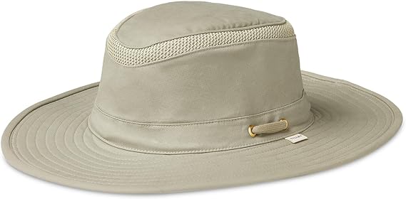


Hiker's Hat
Ordinær pris 1.299,00 kr/
Mva inkludert
Frakt beregnes i kassen.
Tilley lager etter eget sigende verdens beste hatter. En drøy påstand, men så er produktene deres rimelig drøye også. Så drøye at dem, igjen etter Tilleys eget sigende, skal kunne overleve en tur gjennom elefantens fordøyelsessystem. En liten vask og like fint. Påstandene må Tilley stå for, men Nomaden er i alle fall meget fornøyde med produktene og kan gå god for dem.
Trenger du hjelp til å finne riktig størrelse, har vi en størrelsesguide her.
Hiker's Hat inneholder et kjølende innlegg i toppen av hatten som fuktes med vann, og kjøler deg ekstra ned på varme dager. Elementet absorberer vannet og frigjør sakte vann gjennom fordamping.
- Rated UPF 50+
- Guaranteed for life
- Comes with HyperKewl cooling insert
- DWR (Durable Water Repellent) Finish
- Hidden Pocket
- Sustainable
- Buoyant
- Moisture-wicking Hydrofil®
- Tuckaway Wind Cord
- Mesh
- bluesign® approved
- OEKO-TEX® certification

Hiking and Cycling the California Missions Trail
Ordinær pris 349,00 kr/
Mva inkludert
Frakt beregnes i kassen.
A guidebook to walking or cycling the California Missions Trail. The 802 mile (1291km) pilgrimage route from Sonoma to San Diego links 21 Christian missions founded by the Spanish over 200 years ago. It can be enjoyed by walkers of all abilities, or alternatively, 95% of the route is also suitable for road bikes.
The Missions Trail is described in 20 stages of between 16 and 60 miles, with alternative options for cyclists. It can be walked in 50-60 days or cycled in 12-20 days.
- Forfatter: Sandy Brown
- Publisert år: 2022
- Antall sider: 320
- ISBN: 9781786311139

Hiking and Trekking The Japan Alps and Mount Fuji
Ordinær pris 389,00 kr/
Mva inkludert
Frakt beregnes i kassen.
Guidebook to the magnificent Japan Alps, which stretch across the middle of the main island of Honshu, and iconic Mount Fuji. The guide describes nine day-walks and thirteen treks of 2-8 days covering the North, Central and South Alps, as well as the four main routes up Mount Fuji - Japan's highest mountain at 3776m - and a further route on neighbouring Mount Kurodake. The routes visit many of the region's key summits, including several over 3000m.
They are graded according to difficulty, although several entail steep ascents and difficult terrain and a few include scrambling and exposure, calling for a sure foot and a good head for heights. Comprehensive step-by-step route descriptions are accompanied by clear mapping. The Japan Alps and Mount Fuji boast a well-developed walking infrastructure, and the routes make use of the many mountain huts and campgrounds, full details of which are given in the guide.
Some also include the opportunity to visit a traditional hot-spring bath for a refreshing soak after your hike. You will find all the information you will need to plan a successful walking or trekking holiday, with a wealth of advice on travel, bases, accommodation and facilities. There are additional notes on plants and wildlife, the history of hiking in Japan and safety in the mountains, as well as full mountain-hut listings and a helpful glossary.
Inspirational colour photography completes the package, offering a taste of the breathtaking mountain vistas to whet your appetite.
- Publisert: Mars 2020
- Antall sider: 400
- Innbinding: Heftet
- Språk: Engelsk
- ISBN: 9781852849474