Filter
- AA Publishing
- Assouline
- Authentic Models BV
- Borch
- Bradt
- Cabeau
- Calazo
- Cappelen Damm
- Care Plus
- Cicerone
- Colgate
- Columbus Globes
- Craghoppers
- Dapa Maps
- Discovery Walking Guides
- Dr. Bronner
- Eagle Creek
- Editorial Alpina
- Esterbauer Verlag
- ExpressMap
- Eyewitness
- Filson
- Fodor's
- Freytag & Berndt
- Gentlemen's Hardware
- Go Travel
- Hydro Flask
- Insight Guides
- ITM
- Kastel
- Ledlenser
- Lifeventure
- Lonely Planet
- Luster Publishing
- National Geographic
- Nordeca
- Ordnance Survey
- Osprey
- Patagonia
- PopOut
- Reise Know-How
- Rother Walking Guide
- Rough Guides
- Thames & Hudson
- The Urban Explorer
- Tilley
- Touring Club Italiano
- Trailblazer
- Afghanistan
- Albania
- Algerie
- Andorra
- Angola
- Antigua og Barbuda
- Argentina
- Armenia
- Aserbajdsjan
- Australia
- Bahamas
- Bahrain
- Bangladesh
- Barbados
- Belgia
- Belize
- Benin
- Bhutan
- Bolivia
- Bosnia-Hercegovina
- Botswana
- Brasil
- Brunei
- Bulgaria
- Burundi
- Canada
- Chile
- Colombia
- Cookøyene
- Costa Rica
- Cuba
- Danmark
- De forente arabiske emirater
- Djibouti
- Dominica
- Ecuador
- Egypt
- El Salvador
- Elfenbenskysten
- Eritrea
- Estland
- Eswatini
- Etiopia
- Fiji
- Filippinene
- Finland
- Frankrike
- Gabon
- Gambia
- Georgia
- Ghana
- Grenada
- Guatemala
- Guyana
- Haiti
- Hellas
- Honduras
- Hviterussland
- India
- Indonesia
- Irak
- Iran
- Irland
- Island
- Israel
- Italia
- Jamaica
- Japan
- Jemen
- Jordan
- Kambodsja
- Kamerun
- Kapp Verde
- Kasakhstan
- Kenya
- Kina
- Kirgisistan
- Komorene
- Kongo
- Kosovo
- Kroatia
- Kuwait
- Kypros
- Laos
- Latvia
- Lesotho
- Libanon
- Liberia
- Libya
- Liechtenstein
- Litauen
- Luxembourg
- Madagaskar
- Malawi
- Malaysia
- Maldivene
- Mali
- Malta
- Marokko
- Mauritania
- Mauritius
- Mexico
- Moldova
- Monaco
- Mongolia
- Montenegro
- Mosambik
- Namibia
- Nauru
- Nederland
- Nepal
- New Zealand
- Nicaragua
- Niger
- Nigeria
- Nord-Korea
- Nord-Makedonia
- Norge
- Oman
- Pakistan
- Palau
- Palestina
- Panama
- Papua Ny-Guinea
- Paraguay
- Peru
- Polen
- Portugal
- Qatar
- Romania
- Russland
- Rwanda
- Saint Kitts og Nevis
- Saint Lucia
- Saint Vincent og Grenadinene
- Samoa
- San Marino
- Saudi-Arabia
- Senegal
- Serbia
- Seychellene
- Sierra Leone
- Singapore
- Slovakia
- Slovenia
- Solomonøyene
- Somalia
- Spania
- Sri Lanka
- Storbritannia
- Sudan
- Surinam
- Sveits
- Sverige
- Syria
- Sør-Afrika
- Sør-Korea
- Sør-Sudan
- Tadsjikistan
- Taiwan
- Tanzania
- Thailand
- Togo
- Tonga
- Trinidad og Tobago
- Tsjekkia
- Tunisia
- Turkmenistan
- Tuvalu
- Tyrkia
- Tyskland
- Uganda
- Ukraina
- Ungarn
- Uruguay
- USA
- Usbekistan
- Vanuatu
- Venezuela
- Vietnam
- Zambia
- Zimbabwe
- Øst-Timor
- Østerrike
2600 produkter
2600 produkter


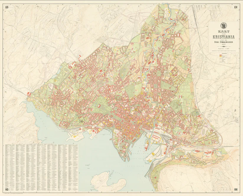
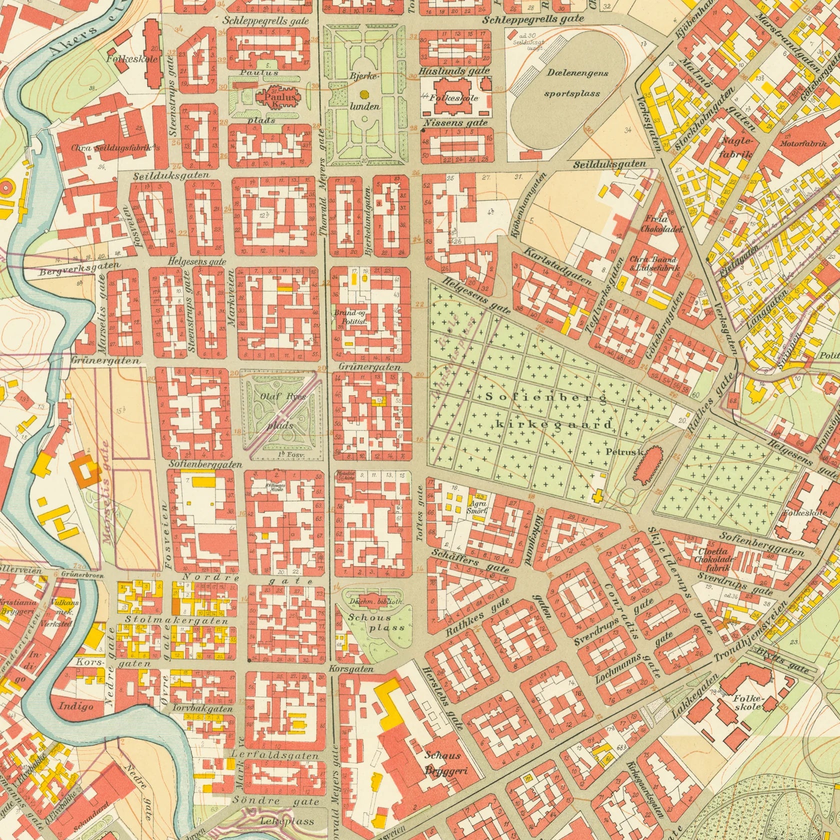
Kristiania 1921
Ordinær pris 2.800,00 kr/
Mva inkludert
Frakt beregnes i kassen.
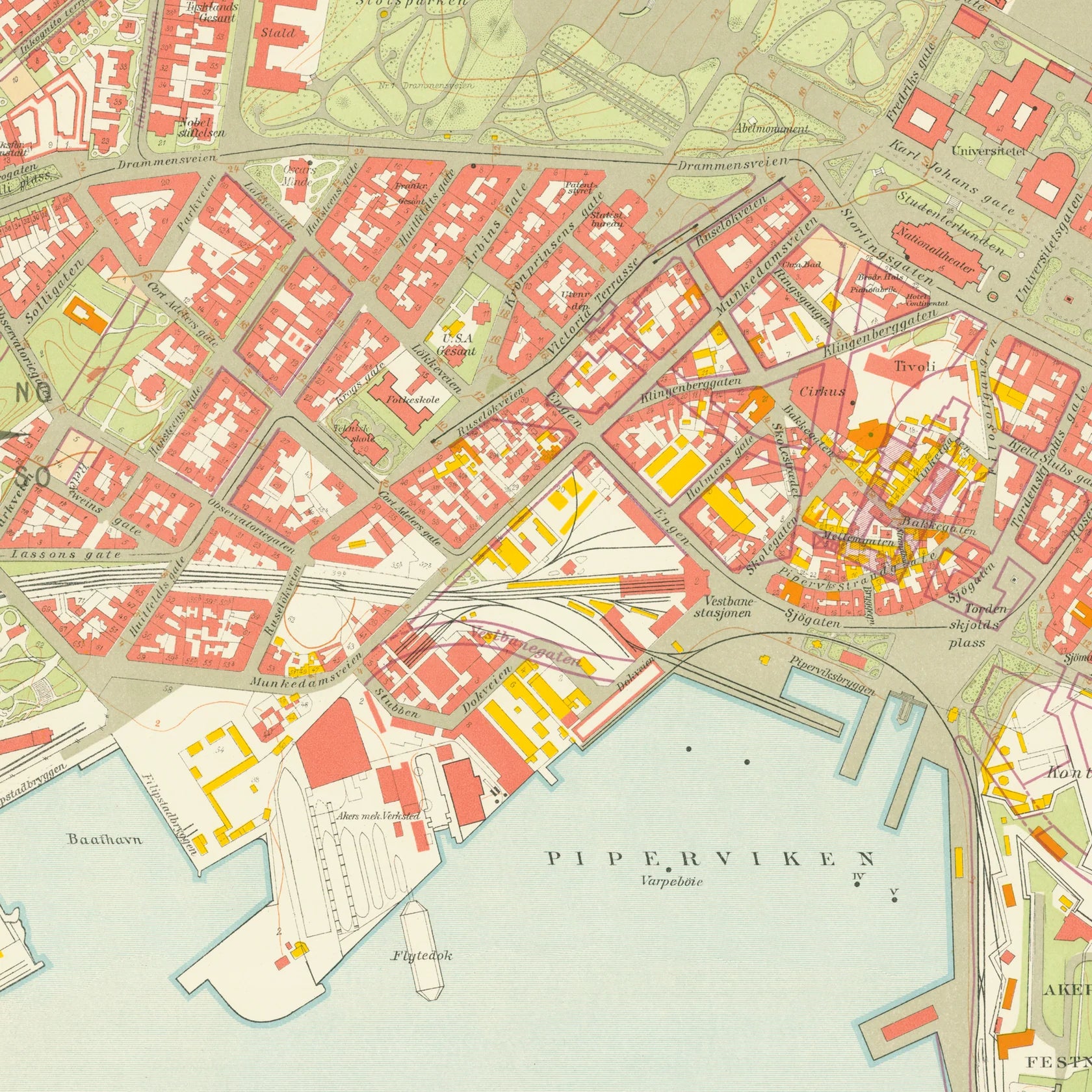
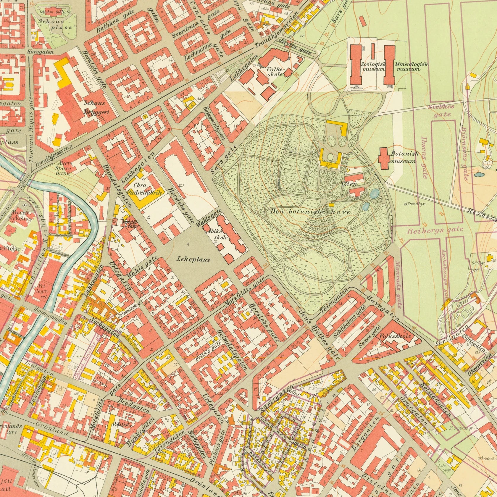
Dette er Dapa Maps' versjon av kartet Kristiania 1921.
Oslos peneste kart? Ja det mener vi. I flere år har Dapa Maps sett på dette kartet og tenkt at de må gjøre med det. Vinteren 2023/2024 har de gjort en digital restaurering av kartet og kan nå vise det frem for allmenheten.
Kartet er opprinnelig tegnet av Byens Oppmaalingsvesen (forløper til Plan- og bygningsetaten) i 1921. Kartet ble da tegnet på 6 ulike kartblad som finnes arkivert hos Byarkivet.
Det Dapa Maps har gjort er å sette kartet sammen til et kart og redigert bort rutenettet slik at lesbarheten blir bedre. De har ikke endret noe på fargene eller på noen andre detaljer.
Dapa Maps
Kartet er laget av Daniel og Pavel fra Dapa Maps. De er to kartografer som tror at livet er best ute, derfor er de opptatt av å lage de peneste kartene de kan for at du kan bli kjent med områdene du liker best. Om du ønsker kan du lese mer om de her.
For hvert kart som selges planter de et tre slik at verden blir litt grønnere 🌳

Kroatien
Ordinær pris 329,00 kr/
Mva inkludert
Frakt beregnes i kassen.
Velkjente danske reisehåndbøker fra Politikens forlag. Guidene inneholder det essensielle ved reisemålet: Beskrivelser av severdigheter, oversikt over aktivitets- og sportstilbud, råd og tips til dem som reiser med barn, samt praktisk informasjon for øvrig. Bøkene byr dessuten på underholdende tematekster og kart, og de er rikt illustrerte. Flotte for kortere turer og populære blant dem som reiser på organiserte opplegg. Hendig lommeformat.
- Forfatter: Tom Nørgaard
- Publisert: 2023
- Utgave: 3. utgave
- Antall sider: 176
- Språk: Dansk
- Innbinding: Heftet


Kubb – Bærenett for ved
Ordinær pris 799,00 kr/
Mva inkludert
Frakt beregnes i kassen.
Ingenting varmer som ved!
Ved må hugges, kuttes, tørkes og bæres - gjerne i flere omganger. Revirs bærenett Kubb er utviklet for å gjøre bære-etappene til en lek.
I vårt praktiske, slitesterke og kjempenyttige bærenett får du med deg ei real vedfyringsøkt så lettvint og greit som det går an. Du slipper dessuten at ullgenseren blir full av kvist og kvast.
Vednettet er produsert i utrolig slitesterkt vokset canvas og kan med hell også brukes til å bære stein, våre hunder, strie unger eller annet du helst vil slippe å plukke opp inntil kroppen.
PS: Vår gamle bestefar Ole hadde en hjemmesnekra variant av dette nettet vi har latt oss inspirere av. Hans triks var å ha den ene hanken rundt nakken for dermed å ha en hånd fri til den bratte trappa opp fra vedkjelleren!


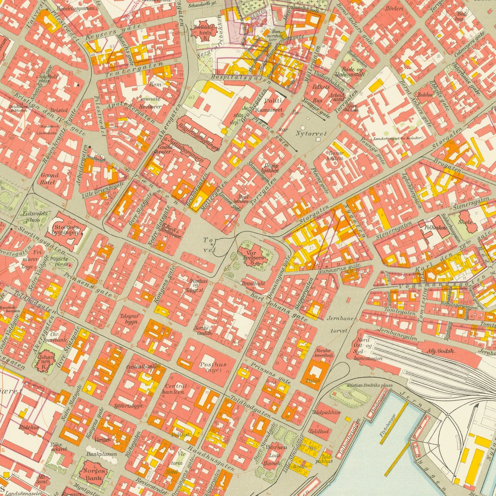
Kvadraturen 1921
Ordinær pris 1.100,00 kr/
Mva inkludert
Frakt beregnes i kassen.
Dette kartet er kun tilgjengelig for kjøp i nettbutikken. Kartet printes når du kjøper, og har derfor noe lengre leveringstid.
Dette er Dapa Maps' utsnitt over deler av Kvadraturen fra kartet Kristiania 1921.
Oslos peneste kart? Ja det mener vi. I flere år har Dapa Maps sett på dette kartet og tenkt at de må gjøre med det. Vinteren 2023/2024 har de gjort en digital restaurering av kartet og kan nå vise det frem for allmenheten.
Kartet er opprinnelig tegnet av Byens Oppmaalingsvesen (forløper til Plan- og bygningsetaten) i 1921. Kartet ble da tegnet på 6 ulike kartblad som finnes arkivert hos Byarkivet.
Det Dapa Maps har gjort er å sette kartet sammen til et kart og redigert bort rutenettet slik at lesbarheten blir bedre. De har ikke endret noe på fargene eller på noen andre detaljer.
Dapa Maps
Kartet er laget av Daniel og Pavel fra Dapa Maps. De er to kartografer som tror at livet er best ute, derfor er de opptatt av å lage de peneste kartene de kan for at du kan bli kjent med områdene du liker best. Om du ønsker kan du lese mer om de her.
For hvert kart som selges planter de et tre slik at verden blir litt grønnere 🌳
Ramme og montering
Dapa Maps har endelig funnet frem til den perfekte rammen og kan nå tilby ramme og montering av kartet.
- Massiv eik
- Glass
- Enkelt å bytte ut kartet
- Mulighet for å henge den både stående og liggende
- 50 x 70 cm (samme som alle Dapas kart)

Kyrgyzstan
Ordinær pris 309,00 kr/
Mva inkludert
Frakt beregnes i kassen.
Bradt Travel Guides er et engelsk forlag med over 200 titler som i hovedsak er skrevet for turister som bruker offentlige transportmidler og egne ben. Bradt har vunnet mange priser for reisehåndbøkene sine som er kjent for å være sterke på mindre kjente reisemål som ikke er overfylt av turister. Forfatterne sørger gjerne for å gi bøkene en personlig ”touch”, og er ikke redde for å være subjektive. Dette gjør dem både til tider morsomme, i tillegg til å være informative og enkle å lese.
Bradt Travel Guides var svært tidlig ute med fokus på viktige emner som økoturisme og den reisendes ansvar som gjest I et fremmed land. Reisehåndbøkene gir råd til hvordan man best kan nyte en eventyrlig reise borte fra turisthordene samtidig som man gjør det mulig for lokale samfunn og natur å dra nytte av besøket. Bradt er guidebøkene til mindre kjente reisemål du ikke vil finne hos andre utgivere. De er gode følgesvenner for eventyrlystne med ryggsekk på et gjennomsnittlig budsjett.
- Forfatter: Laurence Mitchell
- Publisert: April 2019
- Utgave: 4. utgave
- Antall sider: 328
- Innbinding: Heftet
- Språk: Engelsk
- ISBN: 9781784776268

København
Ordinær pris 329,00 kr/
Mva inkludert
Frakt beregnes i kassen.
Velkjente danske reisehåndbøker fra Politikens forlag. Guidene inneholder det essensielle ved reisemålet: Beskrivelser av severdigheter, oversikt over aktivitets- og sportstilbud, råd og tips til dem som reiser med barn, samt praktisk informasjon for øvrig. Bøkene byr dessuten på underholdende tematekster og kart, og de er rikt illustrerte. Flotte for kortere turer og populære blant dem som reiser på organiserte opplegg. Hendig lommeformat.
- Publisert: November 2018
- Utgave: 2. utgave
- Antall sider: 156
- Innbinding: Heftet
- Språk: Dansk
- ISBN: 9788740031638

La Palma & El Hierro
Ordinær pris 299,00 kr/
Mva inkludert
Frakt beregnes i kassen.
Disse små blå vandreguidene i lommeformat har blitt en favoritt blant ferierende med utflukter og natur på programmet. Da de ble sammenliknet med andre fottur-guider i Aftenposten for et par år siden, vant de testen med god margin! Inneholder kart med detaljert målestokk, ruteforslag og hendige tips for fotturister - og for de som vil komme seg rundt ved hjelp av bil eller sykkel.
The go-to La Palma and El Hierro travel guide for discovering the best walks and car tours. Strap on your boots and discover La Palma and El Hierro on foot with the Sunflower La Palma and El Hierro travel guide. And on the days when your feet may have had enough, enjoy some spectacular scenery on one of our legendary car tours.
The Sunflower La Palma and El Hierro guide is indispensable for hiking in La Palma and El Hierro or seeing La Palma and El Hierro by car. El Hierro, the least-visited of all the Canaries, at first appears to be a dried-up, sprawling mountain of rock, rising straight from the sea, treeless and barren. But Noel reveals the island's hidden charms - as remarkable as any in the archipelago.
In natural beauty, La Palma rivals all the other Canary Islands put together. Its immense, abyss-like crater, the Caldera de Taburiente, is considered to be the largest of its kind in the world. Outside the crater, high on the cloud-catching hillsides, 20 million-year-old laurel forests grow as dense as a jungle.
- Forfattere: Noel Rochford
- Publisert: Februar 2020
- Utgave: 8. utgave
- Innbinding: Heftet
- Språk: Engelsk
- ISBN: 9781856915304

La Palma Caldera de Taburiente
Ordinær pris 199,00 kr/
Mva inkludert
Frakt beregnes i kassen.
Publisert år: 2018
Innbinding: falset
Material: papir
Målestokk: 1:25000
Innbinding: falset
Material: papir
Målestokk: 1:25000

La Via de la Plata & Camino Sanabres
Ordinær pris 349,00 kr/
Mva inkludert
Frakt beregnes i kassen.
A guidebook to walking La Via de la Plata and Camino Sanabres pilgrimage route through Spain. The 995km route between Seville and Santiago de Compostela is detailed along with an extension to Astorga for those wishing to join the Camino Frances as well as alternative routes options via Laza or Verin. Designed for reasonably fit walkers, the guidebook offers a six-week itinerary best suited for walking in Spring or Autumn.
Detailed descriptions of each stage, accompanied by 1:100,000 maps, ensure easy navigation and a seamless experience along the route. In addition to route guidance, the guidebook offers valuable information on pilgrim lodging, facilities, and preparation equipping you for a comfortable and well-supported journey. The route itself takes you through notable towns and cities such as Zafra, Marida, Ca¡ceres, Salamanca, Zamora, and Ourense, allowing you to immerse yourself in the rich cultural heritage of Spain.
- Forfatter: Nicole Bukaty
- Publisert: 2023
- Antall sider: 320
- Innbinding: Heftet
- Språk: Engelsk
- ISBN: 9781786310804

Lake Garda
Ordinær pris 169,00 kr/
Mva inkludert
Frakt beregnes i kassen.
Let Marco Polo Lake Garda guide you around this beautiful Italian lake. Explore Lake Garda with this handy, pocket-sized, authoritative guide, packed with Insider Tips. Discover boutique hotels, authentic restaurants, the island's trendiest places, and get tips on shopping and what to do on a limited budget.
There are also lots of ideas for travel with kids. Let Marco Polo show you all that Lake Garda has to offer. Enjoy a cappuccino or 'spritz' in a cafe by the lake, stroll around ancient Roman sites, eat fish under the olive trees or get active windsurfing on the lake, this handy, pocket-size guide will help you discover the best of Lake Garda.
- Publisert: 2023
- Utgave: 11. utgave
- Antall sider: 148
- Innbinding: Heftet
- Språk: Engelsk
- ISBN: 9781914515408

Landevejscykling i Sydeuropa
Ordinær pris 329,00 kr/
Mva inkludert
Frakt beregnes i kassen.
En bog i serien Turen går til guider til 3 fantastiske cykellande, 10 smukke områder og 30 hårde bjergetaper.
Cykelsporten er vokset enormt de seneste år. Flere og flere både licensryttere og motionister tager på cykelrejser i Europa, særligt til bjergene i de store cykelnationer Frankrig, Spanien og Italien. Det er blevet en naturlig del af landevejscykling, at man ind imellem tager sydpå til mere udfordrende terræn. Enten med en cykelklub eller med en gruppe venner.
Bogens formål er at skabe overblik over det spændende landskab og mulighederne for landevejscykling. Samtidig fortæller bogen om ruterne, eller etaperne, og om områdernes historie og de professionelle cykelslag, der er udkæmpet på landevejene her.
- Publisert år: 2019
- Antall sider: 168
- Innbinding: Heftet
- Språk: Dansk
- ISBN: 9788740036336

Langthang Himal East
Ordinær pris 279,00 kr Salgspris 139,50 kr Spar 50%/
Mva inkludert
Frakt beregnes i kassen.
Alpeinvereinskarte er en serie detaljerte vandre- og klatrekart over de østeriske og tyske alper. Høy kvalitet og nøyaktig kartografi gjør disse kartene avgjørende for den erfarene klatrer og fjellturist. Fjellhytter, turstier og campingplasser er tydelig markert på kartene. Noen av kartene er også utgitt i egne skiutgaver.
Publisert år: 1990
Målestokk: 1:50000

Langthang Himal West
Ordinær pris 199,00 kr Salgspris 99,50 kr Spar 50%/
Mva inkludert
Frakt beregnes i kassen.
Alpeinvereinskarte er en serie detaljerte vandre- og klatrekart. Høy kvalitet og nøyaktig kartografi gjør disse kartene avgjørende for den erfarene klatrer og fjellturist. Fjellhytter, turstier og campingplasser er tydelig markert på kartene. Noen av kartene er også utgitt i egne skiutgaver.
- Publisert: 1990
- Innbinding: Falset
- Materiale: Papir
- Målestokk: 1:50 000

Languedoc & Roussillon
Ordinær pris 259,00 kr/
Mva inkludert
Frakt beregnes i kassen.
Glimrende bakgrunnstoff og gode kart kjennetegner rough guides. Dette er en av de mest populære guidebokseriene, beregnet for folk som reiser på egenhånd. Fyldige men ikke avskrekkende, verken I pris eller størrelse. Her finner du informasjon av praktisk og kuriøs karakter, skrevet av engasjerte og kunnskapsrike forfattere. Anbefales spesielt for europeiske reisemål, ettersom serien har lengst erfaring fra dette kontinentet.
- Publisert: Des 2025
- Utgave: 7. utgave
- Antall sider: 332
- Språk: Engelsk
- Innbinding: Heftet
- ISBN: 9781835292631

Languedoc-Roussillon & Western Provence
Ordinær pris 279,00 kr/
Mva inkludert
Frakt beregnes i kassen.
The go-to Western Provence walking guide for over 30 years. Strap on your boots and discover Western Provence on foot with the Sunflower Languedoc-Roussillon and Western Provence travel guide. And on the days when your feet may have had enough, enjoy some spectacular scenery on one of our legendary car tours.
The Sunflower Western Provence guide is indispensable for hiking in Western Provence or seeing Western Provence by car. We cover an area beginning at Aix-en-Provence, heading west via the Luberon and Mont Ventoux to the great Roman cities and the Pont du Gard. We travel north to the Ardeche, the Tarn and the Cirque de Navacelles and south through Herault to Carcassonne and the Canal du Midi, crossing the Corbieres and the Land of the Cathars to the foot of Canigou, holy mountain of the Pyrenees.
These are not tough GR routes, but mostly circular treks suitable for moderately fit people.
- Publisert: 2023
- Innbinding: Heftet
- Utgave: 5. utgave
- Språk: Engelsk
- ISBN: 9781856915526

Lanzarote
Ordinær pris 119,00 kr/
Mva inkludert
Frakt beregnes i kassen.
Marco Polo er svært detaljerte kart som er praktiske og enkle i bruk. 7 klistremerker for å markere spesifikke steder gjør det enda enklere å planlegge reisen. Alle kartene inneholder en omfattende index for enkelt å finne frem.
- Publisert: 2019
- Innbinding: Falset
- Materiale: Plastlaminert
- Målestokk: 1:110 000

Lanzarote
Ordinær pris 229,00 kr/
Mva inkludert
Frakt beregnes i kassen.
Lanzarote Tour & Trail Map covers this big island at a scale of 1:40,000 resulting in the most detailed and toughest map of Lanzarote that you can buy.
We have also included a full island map of La Graciosa at 1:40,000 scale for those people adventuring or staying on the island. Getting such a large island onto one map sheet at 1:40,000 scale means that we have had to split the island into a North-East section on one side and a South-West section on the other side, with a generous overlap between the sections.
In addition to the usual high level of detail on our "Tour & Trail Maps" we have introduced special 'lava' fills to define the lava fields and a 'zocos' fill to define the famous La Geria region. The result is the definitive map of Lanzarote. Super-Durable version is produced on a special polymer substrate using 100% oxygenation inks which results in a map that is virtually tear proof, water proof, baby proof, almost dog proof and will outlast any paper map many times over.
- Publisert: 2024
- Innbinding: Falset
- Materiale: Vannfast papir
- Målestokk: 1:40 000

Laos
Ordinær pris 189,00 kr/
Mva inkludert
Frakt beregnes i kassen.
Tysk kartserie med flotte kart på slitesterkt plastpapir.
Laos at 1:600,000 on an indexed, waterproof and tear-resistant road map from Reise Know-How with topographic and tourist information, plus plans of central Vientiane, Luang Prabang and Vang Vieng. The map, part of the publishers’ highly acclaimed World Mapping Project, is double-sided to show the area at the best possible scale on a convenient size sheet and presents the country in three sections: central Laos on one side, with the far north and the southern “tail” on the reverse.
Road network is easy to see on a clear base which shows the country’s topography by altitude colouring with contours, spot heights and names of mountain ranges. National parks and protected areas are highlighted and internal administrative boundaries are shown with names of the provinces. Road network includes local tracks and indicates scenic routes. A wide range of symbols highlights various places of interest, temples and palaces, museums and archaeological remains, viewpoints, etc. The map has a latitude and longitude grid at intervals of 20’ and 30’respectively. The map is indexed and its legend includes English.
Publisert år: 2023
Innbinding: falset
Material: plastpapir
Målestokk: 1:600000

Laos
Ordinær pris 279,00 kr/
Mva inkludert
Frakt beregnes i kassen.
This Laos guidebook is perfect for independent travellers planning a longer trip. It features all of the must-see sights and a wide range of off-the-beaten-track places. It also provides detailed practical information on preparing for a trip and what to do on the ground.
- Publisert: Desember 2024
- Utgave: 7. utgave
- Antall sider: 325
- Språk: Engelsk
- ISBN: 9781835291627

Lapland
Ordinær pris 289,00 kr/
Mva inkludert
Frakt beregnes i kassen.
This thoroughly updated fourth edition of Bradt's Lapland is the only standalone guidebook in English to this wintry wonderland, a region spanning the northernmost fringes of Norway, Sweden and Finland where there are as many reindeer as people, it never gets dark in summer and never gets light in mid-winter. In this new edition, expert author James Proctor covers all the latest developments, including the most up-to-date information on where to see the Northern Lights (Lapland is the best region in the world for Northern Lights viewing) and where to go husky sledding, reviews of the treehouse hotels which have sprung up across the region, the latest details of how to fly directly to one of the Europe's most far-flung destinations from the UK and USA, plus information on a wide range of summer and winter adventures, from hiking and wild swimming to snowmobiling, wilderness stays and staying in the Icehotel. Everybody has heard of Lapland.
Everybody knows it's the home of Father Christmas. Yet remarkably few people can accurately pinpoint Lapland on a map. Bradt's Lapland lifts the lid off this little-known, enigmatic region and shows that there's much more to Lapland than the man with the long white beard and the red suit.
This is a land of elemental beauty with plenty to offer anyone who's looking to explore the great outdoors without the great crowds. Lapland is vast and empty, a place of indigenous villages, sweeping forests, mighty waterfalls - the raw side of nature here is the region's defining and inescapable characteristic and no visit is complete without leaving the creature comforts of the nearest town well behind. Whether on an organized tour or travelling independently, Bradt's Lapland is the essential travel companion.
- Forfatter: James Proctor
- Publisert: Januar 2022
- Utgave: 4. utgave
- Antall sider: 248
- Innbinding: Heftet
- Språk: Engelsk
- ISBN: 9781784775896

Las Vegas
Ordinær pris 99,00 kr Salgspris 49,50 kr Spar 50%/
Mva inkludert
Frakt beregnes i kassen.
Kart i postkortstørrelse. Folder seg ut som en popoutbok når du åpner dem. Fargerik turistinformasjon med kart over metro og busstraseer, landemerker og lignende. Veldig enkel å håndtere.
Publisert: 2023
Innbinding: pop
Material: papir

Latvia
Ordinær pris 309,00 kr/
Mva inkludert
Frakt beregnes i kassen.
The new, sixth and thoroughly updated edition of Bradt's Latvia remains the only standalone guide to this fascinating and ever-changing Baltic nation. This is a small but enchantingly varied country that will appeal to culture vultures, history buffs, outdoors enthusiasts and foodies alike. Latvia is best known internationally through its capital city Riga, whose centre is a UNESCO World Heritage site combining a medieval core providing testimony of its importance as a port of the Hanseatic League and an outer area containing the most extensive assemblage of Art Nouveau buildings in Europe.
Latvia is much larger than Denmark or Switzerland yet, with a population of under two million, is one of the most verdant countries in Europe. A low-lying landscape of forests, lakes and marshes offers an increasing range of rural tourism options facilitated by recent EU infrastructural investments. Why not go hiking or kayaking in Gauja National Park, go cycling or explore Latgale's lakes? In summer, Latvia's Baltic Sea coast comes into its own: almost 500km long, much comprising pristine sandy beaches backed by dunes.
- Publisert: Juni 2024
- Utgave: 6. utgave
- Antall sider: 312
- Innbinding: Heftet
- Språk: Engelsk
- ISBN: 9781804690406

Lebanon
Ordinær pris 299,00 kr/
Mva inkludert
Frakt beregnes i kassen.
This new, thoroughly updated third edition of Bradt's Lebanon remains the only English-language guide dedicated to the smallest country on the Asian continent. Comprehensively updated throughout to reflect recent economic, political and social changes, it includes revised and new listings for hotels, restaurants, and what to see and do, catering for all types of travellers and budgets. Although only half the size of Wales, Lebanon offers extraordinary diversity.
Some of the world's oldest human settlements, including the Phoenician ports of Tyre and Byblos - two of Lebanon's five World Heritage sites - sit alongside modern Beirut. The absorbing capital is popular for its world-renowned cuisine, eclectic nightlife, mosaic of peoples and kaleidoscope of religions. In Lebanon's second city, Tripoli, busy medieval souks are watched over by a vast Crusader castle.
Nearby, snow-capped mountains and the lush Qadisha Valley with its snaking river and waterfalls provide entertainment for skiers and hikers (the latter also well served by the Lebanon Mountain Trail, which runs virtually the length of the country). Three hundred days of sunshine per year makes Lebanon a 'go anytime' destination, with the Mediterranean coastline particularly drawing sun-seekers and water-sports enthusiasts. Wildlife-lovers can enjoy Shouf Biosphere Reserve (with its famed cedar trees, the national emblem) and the Aammiq Wetlands, while Lebanon has become a major destination for religious tourism, and vinophiles can visit numerous Bekaa Valley wineries of international repute.
- Forfatter: Paul Doyle
- Publisert: April 2023
- Utgave: 3. utgave
- Antall sider: 376
- Innbinding: Heftet
- Språk: Engelsk
- ISBN: 9781784776985

Lefkada, Paxos & Antipaxos
Ordinær pris 229,00 kr/
Mva inkludert
Frakt beregnes i kassen.
Vanntett og holdbart turkart over Lefkas, Paxos og Antipaxos.
- Publisert: Mars 2021
- Innbinding: Falset
- Materiale: Plastpapir
- Målestokk: 1:40 000, 1:25 000 (Paxos og Antipaxos)

Lesotho
Ordinær pris 179,00 kr Salgspris 89,50 kr Spar 50%/
Mva inkludert
Frakt beregnes i kassen.
Infomap™ er kongen av road-trip kart i den sørlige delen av afrika. Godt detaljerte og oppdaterte veikart i papir. Kartene inneholder også skogs - og landeveier for deg som vil utenfor allfarvei. Perfekt kompanjong på safari eller andre eventyr. Har gps-koordinater.
Publisert år: 2018
Innbinding: falset
Material: papir
Målestokk: 1:400000

Lesotho & Swaziland (Eswatini)
Ordinær pris 169,00 kr Salgspris 84,50 kr Spar 50%/
Mva inkludert
Frakt beregnes i kassen.
ITM har kart over hele verden og de spesialiserer seg på land litt utenfor allfarvei. Beliggenheten til landets nasjonalparker, historiske monumenter, de viktigste veiene o.L. Finner du inkludert i kartene. Samtlige landkart har ofte et bykart over hovedstaden.
Fra ITM: ITM is pleased to re-introduce their coverage of two countries of africa that are fairly unique. Both were well-established entities when settlers arrived, and both were able to maintain their identities throughout the colonial era, as protectorates. Lesotho is quite mountainous, with a poorly developed road network, so is a travel adventure destination. It occupies side 1, along with an inset of maseru, the capital. Swaziland, which has recently changed its name for local purposes to eswatini, occupies side 2, with an inset of mbabane, its capital. Both countries are easy to access from south africa, and are well worth visiting. We have also added two lists showing the top attractions of both countries. Both are land-locked countries either adjacent to or surrounded by south africa; both are essentially agricultural countries, although lesotho s mountainous terrain offers considerable touristic appeal, particularly the sani pass. Legend includes: Highway, main road, secondary road, street, pathway, railway, park, lake, international airport, gas station, church, hotel, museum, library, restaurant, shopping, police station, bank, school, stadium, bus terminal, golfing, etc. 2nd edition 2019. Scales: Lesotho 1:350.000, swailand 1:200.000.
Publisert år: 2019
Innbinding: falset
Material: papir
Målestokk: 1:350000

Libya
Ordinær pris 169,00 kr/
Mva inkludert
Frakt beregnes i kassen.
Tysk kartserie med flotte kart på slitesterkt plastpapir.
Indexed, waterproof and tear-resistant road map of Libya with topographic and tourist information, published by Reise Know-How as part of their highly acclaimed World Mapping Project. The map is double-sided to provide the best balance between a good scale and a convenient size sheet.
Road and rail networks are easy to see on a clear base which shows the area’s topography by altitude colouring with contours, spot heights, mountain passes, and names of mountain ranges. The map also shows deserts, salt lakes and seasonal rivers. Internal administrative boundaries are shown with names of the provinces. Names of main towns are also given in Arabic script. Road network includes unsurfaced roads and seasonal tracks and indicates locations of fuel supplies. A wide range of symbols highlight various places of interest, including national parks and protected areas, oasis and water wells, UNESCO world heritage sites, archaeological remains, campsites, caves, beaches, etc. Oil wells and pipelines are also marked, as well as the course of the “Great-Man-Made-River” project. The map has a latitude and longitude grid at intervals of 1° and an index of place names. Map legend includes English.
Publisert år: 2011
Innbinding: falset
Material: plastpapir
Målestokk: 1:1600000

Libya: Jebel Acacus
Ordinær pris 199,00 kr Salgspris 99,50 kr Spar 50%/
Mva inkludert
Frakt beregnes i kassen.
- Publisert: 2006
- Innbinding: Falset
- Materiale: Papir
- Målestokk: 1:100 000