29 produkter
29 produkter


29 produkter
740 Mauritius & Rodrigues
Ordinær pris 169,00 kr(Edition updated in 2023), MICHELIN National Map Maurice (Mauritius) will give you an overall picture of your journey in (Mauritius) thanks to its clear and accurate mapping scale 1/80,000. Our National Map Series will help you easily plan your safe and enjoyable journey thanks to a comprehensive key, a complete name index as well a clever time & distance chart. Michelin's driving information will help you navigate safely in all circumstances.
In addition, some MICHELIN National Maps are cross-referenced with the MICHELIN Green Guide highlighting destinations worth stopping for! With MICHELIN National Maps, find more than just your way! MICHELIN NATIONAL MAPS feature: Up-to-date mapping.
A scale adapted to the size of the country. A clear and comprehensive key. Distance and time chart. Place name index. Driving and road safety information. Tourist sights information. Our maps are regularly updated even if the ISBN does not change.
744 Africa: Tunisia
Ordinær pris 169,00 krMichelin er en av verdens beste, og best kjente, kartserier. Kartene har glimrende kartografi. Rød serie, kalt “national”. Dekker et enkelt land eller en gruppe land primært med hovedferdselsårer.
Publisert år: 2020
Innbinding: falset
Material: papir
Målestokk: 1:800000
745 Africa: North East & Arabia
Ordinær pris 169,00 krMichelin er en av verdens beste, og best kjente, kartserier. Kartene har glimrende kartografi. Rød serie, kalt “national”. Dekker et enkelt land eller en gruppe land primært med hovedferdselsårer.
Publisert år: 2019
Innbinding: falset
Material: papir
Målestokk: 1:4000000
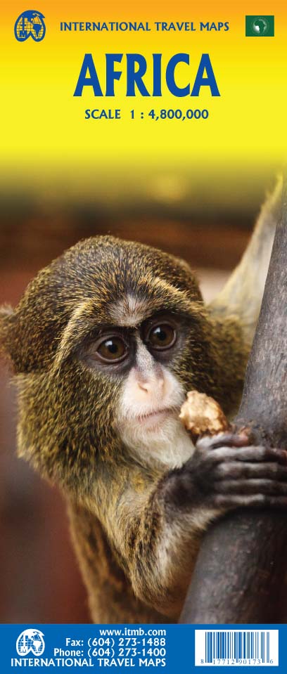
Africa
Ordinær pris 199,00 krAfrica is a huge continent. No one apart from us has successfully prepared a digital data base for the entire continent and this edition includes numerous updates to road information and shifting political realities. We have updated roads whenever reliable data indicates improvements, such as connections between the southern tip of Morocco and the road leading to Nouakchott, in Mauritania. Politically, we all know of things that do not affect maps - the closed border between Algeria and Morocco, the coup in Guinea, the continued instability of Libya, the generally better degree of stability in Somalia, the on-going troubles in South Sudan - but generally, the continent of 54 nation states and a few colonial enclaves has survived two years of destabilizing Covid ravages rather well. Tourism is gradually recovering, and map sales improving.
This is a very important map in that it brings all of the countries and islands relative to the African continent into perspective. We are pleased to bring to your attention an updated version of a part of the world that is crucially important.
Africa: Congo & Central African Republic
Ordinær pris 199,00 krITM har kart over hele verden og de spesialiserer seg på land litt utenfor allfarvei. Beliggenheten til landets nasjonalparker, historiske monumenter, de viktigste veiene o.L. Finner du inkludert i kartene. Samtlige landkart har ofte et bykart over hovedstaden.
The Congo River forms the boundary between the former Belgian Congo and the former French colony called Congo. The two countries bear little resemblance to each other. After independence, French Congo became the People’s Republic of Congo, which has now been shortened to just the Congo Republic. The other Congo became Zaire, and then the Democratic Republic of Congo, or DEM Congo for short. This is a double-sided map with two relatively amicable countries sharing the sheet. Side 1 is Congo, with its capital of Brazzaville, founded 1883, which was the former capital of French Equatorial Africa. It stretches from the Atlantic Ocean, with a port at Pointe Noire, inland to the border of the Central African Republic, or CAR, for short. Although there is a rail line from Pointe-Noire to Brazzaville, due to an undeveloped infrastructure, much of the traffic is along the vast Congo River. The second side of the sheet is devoted to the CAR, with its capital at Bangui. Again, it is joined by a rail line to the coast, at Dakar, Senegal, but the Congo River serves as its main transportation link with the interior. The road network seems to have improved since I was there, but both countries definitely fall into the category of countries for adventure travel, not routine tourism!
Publisert: 2025
Innbinding: falset
Material: papir
Målestokk: 1:1,500,000
Angola
Ordinær pris 129,00 kr Salgspris 64,50 kr Spar 50%Infomap™ er kongen av road-trip kart i den sørlige delen av afrika. Godt detaljerte og oppdaterte veikart i papir. Kartene inneholder også skogs - og landeveier for deg som vil utenfor allfarvei. Perfekt kompanjong på safari eller andre eventyr. Har gps-koordinater.
Publisert år: 2014
Innbinding: falset
Material: papir
Målestokk: 1:1 600 000
Angola
Ordinær pris 199,00 krITM har kart over hele verden og de spesialiserer seg på land litt utenfor allfarvei. Beliggenheten til landets nasjonalparker, historiske monumenter, de viktigste veiene o.L. Finner du inkludert i kartene. Samtlige landkart har ofte et bykart over hovedstaden.
Fra ITM: Angola is emerging as one of Africa’s growing travel destinations. After a long period of isolation, the country now welcomes tourists, and is investing in improved infrastructure to make it easier to travel around this vast country. New resort hotels are attracting tourists to beach hotels along the coast and inland hotels are being upgraded. The road network is improving, but still is a work in progress. The USA is building a new trans-Africa railway, but its future is uncertain due to Trump’s cutbacks. The map includes a detailed inset map of Luanda, the capital, and a list of Top Attractions. Angola is still a developing country, so travel here is more adventuresome than in eastern Africa for example, but it is growing in popularity.
Publisert år: 2025
Innbinding: falset
Material: papir
Målestokk: 1:1,430,000
Angola
Ordinær pris 169,00 krTysk kartserie med flotte kart på slitesterkt plastpapir.
Reise Know-How maps (world mapping project series) are easy-to-read, waterproof and highly durable travel maps specifically designed for everyday use on the road.
The maps combine state-of-the-art, GPS-compatible cartography (including hypsometric tints and contour lines) with a detailed rendering of road networks and touristic information. They offer the best possible scale, level of detail and readability, be it a map of a small island or half a continent.
The maps feature a detachable paper sleeve so that the maps can be folded easily and fit in every pocket. Although printed on plastic, a special coating makes sure the maps retain a paper-like feel and can even be written on with a pencil.
Publisert år: 2016
Innbinding: falset
Material: plastpapir
Målestokk: 1:1,400000
Burkina Faso & Niger
Ordinær pris 149,00 krITM har kart over hele verden og de spesialiserer seg på land litt utenfor allfarvei. Beliggenheten til landets nasjonalparker, historiske monumenter, de viktigste veiene o.L. Finner du inkludert i kartene. Samtlige landkart har ofte et bykart over hovedstaden.
Fra ITM: Burkina Faso and Niger on a double-sided, indexed map from ITMB, presenting each country separately at 1:1,000,000 1:1,950,000 respectively and accompanied by street plans of Ouagadougou, Bobo-Dioulasso and Niamey. Altitude colouring shows the topography (with bands in feet in Burkina Faso and in metres in Niger). In Burkina Faso the map indicates areas of periodic inundation, whilst in Niger numerous water wells, salt pans, sand dunes and lava fields are also marked. In both countries parks and nature reserves are highlighted.
Road network indicates seasonal roads and shows locations of fuel supplies and border crossings, plus distances on main routes. Airports and aerodromes for small craft are marked; towns are annotated with symbols indicating what facilities can be found there. Each map has latitude and longitude lines (at 1° in Burkina Faso and 2° in Niger), plus a separate index.
Street plans, annotated with names of hotels, various tourist facilities and main buildings cover Ouagadougou (with an enlargement for the town cente), Bobo-Dioulasso and Niamey.
Publisert år: 2013
Innbinding: falset
Material: papir
Målestokk: 1:1950000
Congo - Republic & Democratic Republic
Ordinær pris 249,00 krTysk kartserie med flotte kart på slitesterkt plastpapir.
Ethiopia & Eritrea
Ordinær pris 199,00 krITM har kart over hele verden og de spesialiserer seg på land litt utenfor allfarvei. Beliggenheten til landets nasjonalparker, historiske monumenter, de viktigste veiene o.L. Finner du inkludert i kartene. Samtlige landkart har ofte et bykart over hovedstaden.
Fra ITM: Double-sided map with Ethiopia at 1:1,900,000 accompanied by a street plan of Addis Ababa, with on the reverse Eritrea at 1:915,000 with a plan of Asmara. Both road maps are indexed and show the topography by altitude colouring: in Ethiopia with bands in metres and peak heights given in both metres and feet, and in Eritrea with bands in feet and peak heights either in feet and metres or in feet only.
Ethiopia, Somalia, Eritrea & Djibouti
Ordinær pris 169,00 krEthiopia with Eritrea, Somalia and Djibouti at 1:1,800,000 on a light, waterproof and tear-resistant, indexed road map, providing both topographic and tourist information. The map, published by Reise-Know-How as part of their highly acclaimed World Mapping Project, is double-sided, with a generous overlap between the sides, to provide the best balance between a good scale and a convenient size sheet.
Road and rail networks are easy to see on a clear base which presents topography by altitude colouring with contours, spot heights, mountain passes and names of mountain ranges. Salt pans, swamps, seasonal rivers and lakes, oases, caves, hot springs and coral reefs are indicated. Road network includes seasonal local tracks, gives driving distances on main roads, and shows locations of fuel supplies and border crossings. Local airfields are also marked. Internal administrative boundaries are shown with names of the provinces. National parks and protected areas are marked and symbols highlight various places of interest, including UNESCO world heritage sites, archaeological remains, churches and monasteries, mosques, viewpoints, beaches, etc. Campsites, particularly within Ethiopia, and locations of wells and water tanks are indicated.
The map has a grid with latitude and longitude at intervals of 1º, and a separate index of localities for each country, plus a list of national parks and reverse. Map legend includes English.
Lesotho
Ordinær pris 179,00 kr Salgspris 89,50 kr Spar 50%Infomap™ er kongen av road-trip kart i den sørlige delen av afrika. Godt detaljerte og oppdaterte veikart i papir. Kartene inneholder også skogs - og landeveier for deg som vil utenfor allfarvei. Perfekt kompanjong på safari eller andre eventyr. Har gps-koordinater.
Publisert år: 2018
Innbinding: falset
Material: papir
Målestokk: 1:400000
Lesotho & Swaziland (Eswatini)
Ordinær pris 169,00 kr Salgspris 84,50 kr Spar 50%ITM har kart over hele verden og de spesialiserer seg på land litt utenfor allfarvei. Beliggenheten til landets nasjonalparker, historiske monumenter, de viktigste veiene o.L. Finner du inkludert i kartene. Samtlige landkart har ofte et bykart over hovedstaden.
Fra ITM: ITM is pleased to re-introduce their coverage of two countries of africa that are fairly unique. Both were well-established entities when settlers arrived, and both were able to maintain their identities throughout the colonial era, as protectorates. Lesotho is quite mountainous, with a poorly developed road network, so is a travel adventure destination. It occupies side 1, along with an inset of maseru, the capital. Swaziland, which has recently changed its name for local purposes to eswatini, occupies side 2, with an inset of mbabane, its capital. Both countries are easy to access from south africa, and are well worth visiting. We have also added two lists showing the top attractions of both countries. Both are land-locked countries either adjacent to or surrounded by south africa; both are essentially agricultural countries, although lesotho s mountainous terrain offers considerable touristic appeal, particularly the sani pass. Legend includes: Highway, main road, secondary road, street, pathway, railway, park, lake, international airport, gas station, church, hotel, museum, library, restaurant, shopping, police station, bank, school, stadium, bus terminal, golfing, etc. 2nd edition 2019. Scales: Lesotho 1:350.000, swailand 1:200.000.
Publisert år: 2019
Innbinding: falset
Material: papir
Målestokk: 1:350000
Libya
Ordinær pris 169,00 krTysk kartserie med flotte kart på slitesterkt plastpapir.
Indexed, waterproof and tear-resistant road map of Libya with topographic and tourist information, published by Reise Know-How as part of their highly acclaimed World Mapping Project. The map is double-sided to provide the best balance between a good scale and a convenient size sheet.
Road and rail networks are easy to see on a clear base which shows the area’s topography by altitude colouring with contours, spot heights, mountain passes, and names of mountain ranges. The map also shows deserts, salt lakes and seasonal rivers. Internal administrative boundaries are shown with names of the provinces. Names of main towns are also given in Arabic script. Road network includes unsurfaced roads and seasonal tracks and indicates locations of fuel supplies. A wide range of symbols highlight various places of interest, including national parks and protected areas, oasis and water wells, UNESCO world heritage sites, archaeological remains, campsites, caves, beaches, etc. Oil wells and pipelines are also marked, as well as the course of the “Great-Man-Made-River” project. The map has a latitude and longitude grid at intervals of 1° and an index of place names. Map legend includes English.
Publisert år: 2011
Innbinding: falset
Material: plastpapir
Målestokk: 1:1600000
Libya: Jebel Acacus
Ordinær pris 199,00 kr Salgspris 99,50 kr Spar 50%Mauritania & Mali
Ordinær pris 169,00 kr Salgspris 84,50 kr Spar 50%ITM har kart over hele verden og de spesialiserer seg på land litt utenfor allfarvei. Beliggenheten til landets nasjonalparker, historiske monumenter, de viktigste veiene o.L. Finner du inkludert i kartene. Samtlige landkart har ofte et bykart over hovedstaden.
Fra ITM: In this edition, we have combined Mauritania with Mali. Although both are interesting countries, the two fit naturally together as a unit, albeit at slightly differing scales. Technically, this should be a 1st edition map, as it is the first time we have combined these two desert countries on to one sheet, but I’ll let Robert at the Library of Congress worry about the niceties of bibliographic accuracy as soon as Trump allows him to do the work he loves for a salary. Mauritania was one of the most unusual countries I visited as a young traveller. Of course, I had an advantage, in that I was too young to know that what I was doing was supposed to be impossible. I entered from what was then the Spanish Sahara via a piste (a sandy track with multiple pathways, only some of which avoid soft sand), travelling with a young Bedouin man. In Zouerate, a mining camp, I had to tie my VW campervan onto a railway flatbed car, and endure hundreds of kilometres of a sand dune wasteland before reaching Choum, and a siding where I could off-load the vehicle. The track south to Nouakchott was covered with sand and treacherous. Nowadays, there is a paved road to the southern border of Morocco, and a good road all the way along the coast to Rosso, where a ferry can take one across to Senegal. Mali adjoins Mauritania, both being formerly part of French West Africa. The capital, Bamako, is an interesting town with quite a bit of colonial architecture still in place. East of there is Djenne, a ‘forbidden’ city for infidels when I was there (see cover photo), but a fascinating mud-brick city. Further east again is Mopti, a river port where camel caravans off-load tablets of salt mined still far in the Sahara for transport by boat to Dakar. Further east again is Timbuktu (or Tombouctou as it is now spelled), at one time the most exotic isolated destination known to mankind. Further south is the Bandiagara escarpment, a must-see living area for locals who have created a living space from the sheer walls of the cliff. Both countries are fascinating places to visit.
Publisert år: 2019
Innbinding: falset
Material: Papir
Målestokk: 1:2,200,000 / 1:900,000
Reisekart Morocco
Ordinær pris 219,00 krReisekart som dekker Marokko, fra den tyske produsenten Reise Know-How:
Morocco at 1:1,000,000 on an indexed road map with topographic and tourist information, printed on light, waterproof and tear-resistant plastic paper. The map, part of Reise Know-How’s highly acclaimed World Mapping Project, is double-sided to provide the best balance between a good scale and a convenient size sheet. The map divides Morocco north/south with a generous overlap between the sides: Marrakesh, the Toubkal Massif and Essaouira are included on both sides. The southern part of Western Sahara is shown as an inset at 1:2,500,000. Names of larger towns are additionally given in Arabic.
Topography is indicated by altitude colouring with spot heights and mountain passes, names of mountain ranges and peaks, seasonal rivers and lakes, salt pans, oases and wells. National parks are highlighted. Road information includes dirt roads and tracks, indicating scenic routes, locations of petrol stations and river fords, plus intermediate driving distances on main routes. Railways and local airfields are also shown. Symbols mark various places of interest: campsites, UNESCO World Heritage sites, forts and religious buildings, archaeological sites, beaches, surfing and fishing locations, viewpoints, etc. The map has a latitude/longitude grid at intervals of 1º and an index of localities. Map legend includes English.
Mount Elgon - Map and Guide
Ordinær pris 149,00 kr Salgspris 74,50 kr Spar 50%Kart over Mount Elgon. Kartet ble publisert i 1989, men er fortsatt det mest oppdaterte på området i 2025.
Nigeria & Niger
Ordinær pris 149,00 krITM har kart over hele verden og de spesialiserer seg på land litt utenfor allfarvei. Beliggenheten til landets nasjonalparker, historiske monumenter, de viktigste veiene og lignende finner du inkludert i kartene. Samtlige landkart har ofte et bykart over hovedstaden.
4th edition November 2018. Nigeria in 1:1.600.000 and Niger in 1:2.000.000. Inset maps of Lagos Island, Lagos Region, Benin City, Abuja & Niamey.
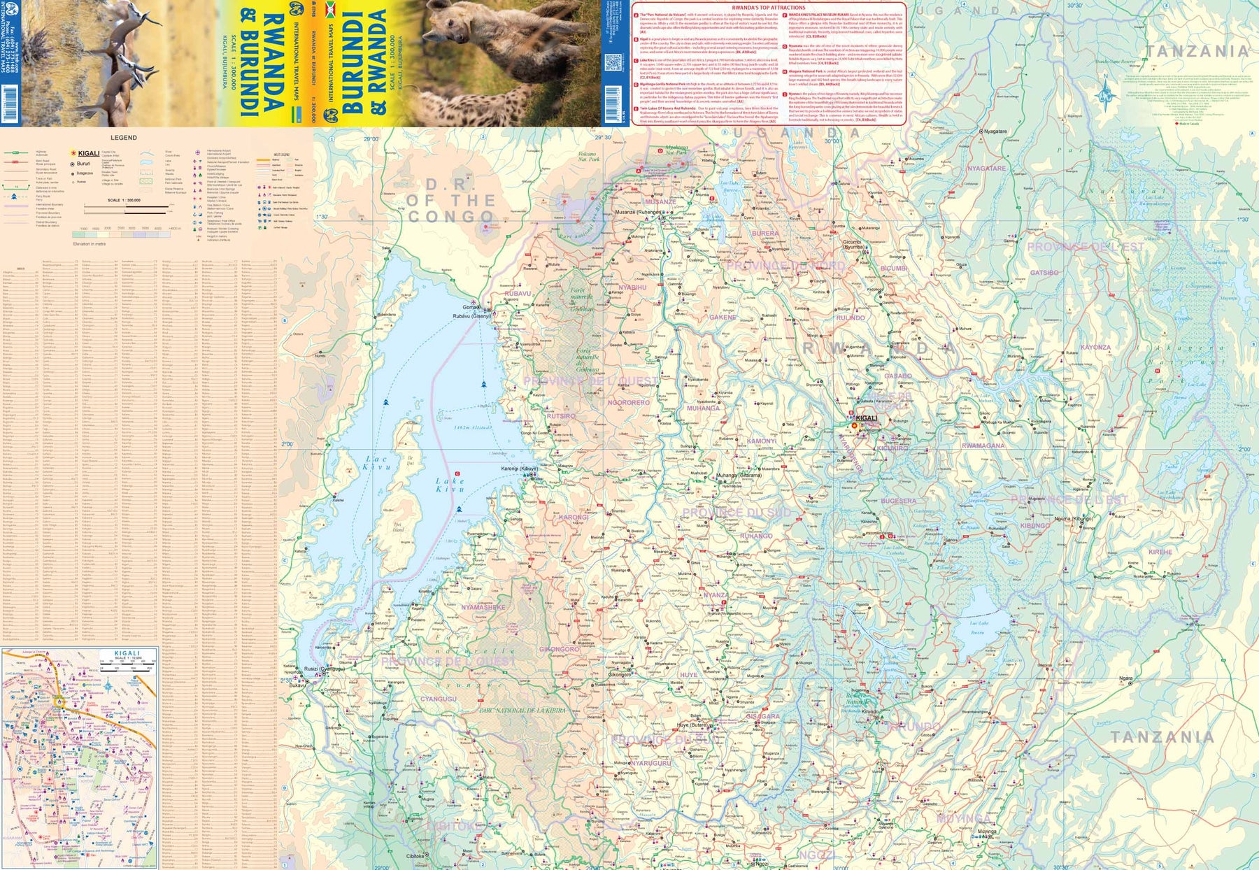
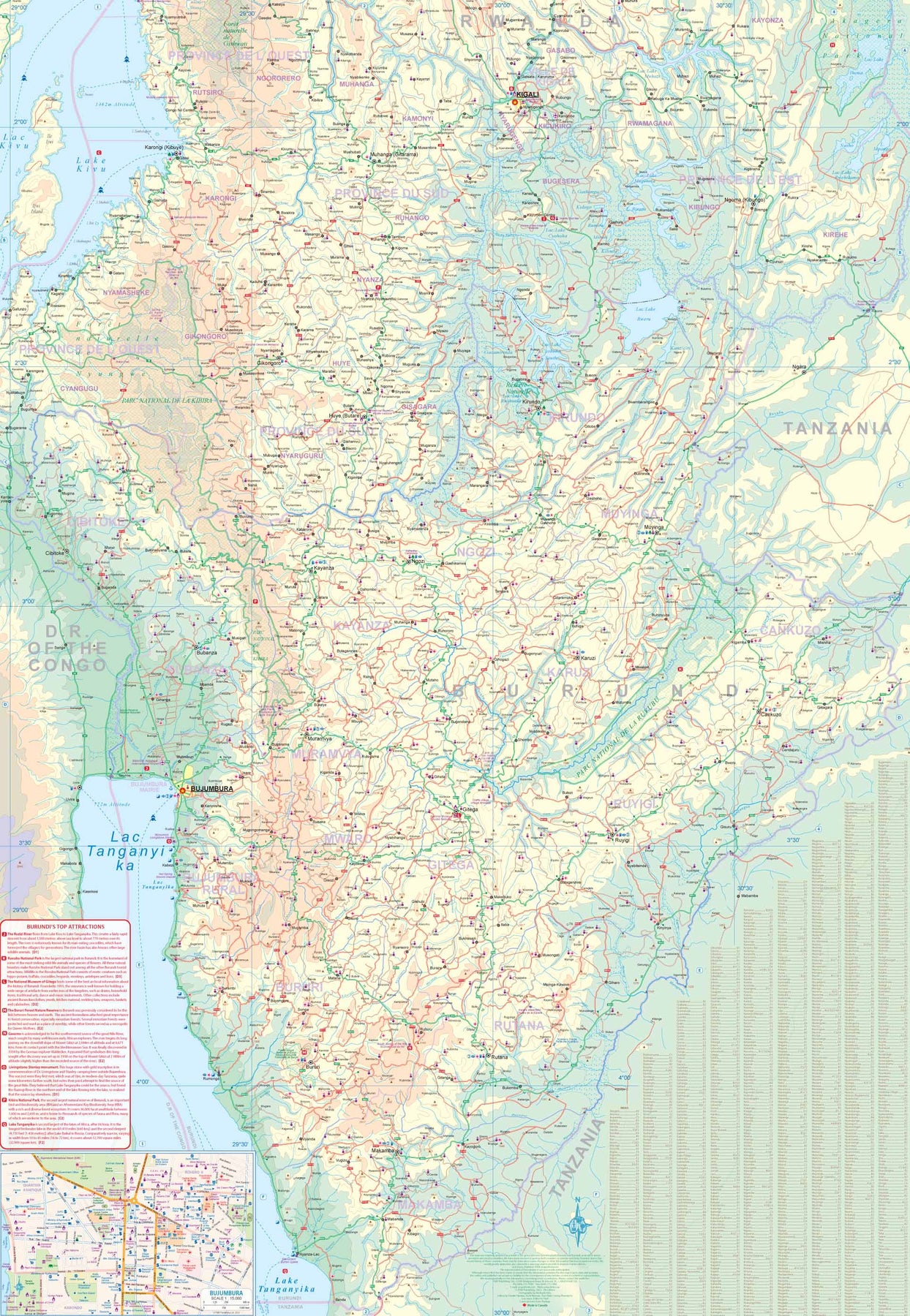
Rwanda & Burundi
Ordinær pris 199,00 krITM har kart over hele verden og de spesialiserer seg på land litt utenfor allfarvei. Beliggenheten til landets nasjonalparker, historiske monumenter, de viktigste veiene og lignende finner du inkludert i kartene. Samtlige landkart har ofte et bykart over hovedstaden.
Sierra Leone & Freetown
Ordinær pris 199,00 krITM har kart over hele verden og de spesialiserer seg på land litt utenfor allfarvei. Beliggenheten til landets nasjonalparker, historiske monumenter, de viktigste veiene o.L. Finner du inkludert i kartene. Samtlige landkart har ofte et bykart over hovedstaden.
Fra ITM: The West African country of Sierra Leone is one of the hidden gems of Africa. A relatively stable and peaceful country, it moved into independence easily. English remains the common language of communication, which is nice. The only urban area of any size in the country is the Capital, Freetown. The name dates from the time of the American Revolution, where slaves who fought for the British army were given sanctuary far from the rebellious whites determined to re-enslave them. Rather than having a Top Attractions list, we have devoted a considerable amount of space on the country side to note its history and points of interest. Side 2 is a detailed map of Freetown, with an inset map of the nearby Peninsula Mountains. Freetown boasts the largest natural harbour in the world and has a 500-year-old Cotton tree in its town centre. This is definitely a country worth visiting!
Publisert: 2025
Innbinding: falset
Material: papir
Målestokk: 1:500,000/1:13,000
Somalia & Horn of Africa
Ordinær pris 169,00 krITM har kart over hele verden og de spesialiserer seg på land litt utenfor allfarvei. Beliggenheten til landets nasjonalparker, historiske monumenter, de viktigste veiene og lignende finner du inkludert i kartene. Samtlige landkart har ofte et bykart over hovedstaden.
Fra ITM: 3rd Edition Somalia is one of the more itneresting off-the-beaten-path countries. The area around Mogadishu prefers to call itself Somalia, but controls only a portion of the overall country area. Then there is Jubaland, on the Kenyan border, aligned very closely to the former Italian colony boundaries of the same name. Truuly, an amazing juxtaposition of countries within countries! the reverse side of the sheet presents a vey interesting regional perspective of the area between the northern border of Ethiopia, a small portion of Sudan and a reasonable portion of South Sudan, all of Uganda, most of Kenya, all of Djibouti and a fair portion of Eritrea, as well as the former Aden portion of war-torn Yemen. The strategic island of Socotra is in the upper right corner. This is a fascinating regional map, never before published to my knowledge, of an extremely significant part of the world. Think of the following: Socotra guards and controls access to the Gulf of Aden and the Red Sea, leading to the Suez Canal. What an interesting part of the world! How can anyone not be captivated by such wonderfully exotic names as Hargeysa, Boosaaso, or Kismayyo? Somalia and the region of the Horn remain crucially important to world peace, so this map is important.
Publisert år: 2020
Innbinding: falset
Material: plastpapir
Målestokk: 1:1,700,000 / 1:2,400,000
Togo & Benin
Ordinær pris 169,00 krITM har kart over hele verden og de spesialiserer seg på land litt utenfor allfarvei. Beliggenheten til landets nasjonalparker, historiske monumenter, de viktigste veiene og lignende finner du inkludert i kartene. Samtlige landkart har ofte et bykart over hovedstaden.
Fra ITM: The two small countries squeezed between Ghana on the west and Nigeria on the east developed out of the European colonialization of most of Africa Germany, under Kaiser Bill, was determined to create an empire to rival that of Britain, and seized a portion of the coastline close to the British-held area of Ghana and held on to it until WW1 ended Germany’s colonial aspirations. Britain and France jointly governed Togo briefly, but the territory was ceded to France until independence was granted in the 1960s. Neighbouring Benin (formerly the French colony of Dahomey) was all that the French colonial office could obtain of the rich coastal plain until the German defeat in WW1, which gained it Togo and German Cameroun, further to the east. Both countries have their points of interest, but to this day have little to do with each other. There is one border crossing on the coast, and a couple of others much farther inland, but each country operates on a north-south basis, not an east-west one. The map includes inset maps of Lome, the capital of Togo, and Porto Novo, in Benin, which is now the capital. Togo’s best sites are noted in a red inset box, with a separate box for Benin.
Tunisia
Ordinær pris 239,00 krTysk kartserie med flotte kart på slitesterkt, vannfast plastpapir.
Kenya
Ordinær pris 199,00 krReise Know-How maps (world mapping project series) are easy-to-read, waterproof and highly durable travel maps specifically designed for everyday use on the road. The maps combine state-of-the-art, GPS-compatible cartography (including hypsometric tints and contour lines) with a detailed rendering of road networks and touristic information. They offer the best possible scale, level of detail and readability, be it a map of a small island or half a continent.
The maps feature a detachable paper sleeve so that the maps can be folded easily and fit in every pocket. Although printed on plastic, a special coating makes sure the maps retain a paper-like feel and can even be written on with a pencil.
Uganda
Ordinær pris 219,00 krIndexed, waterproof and tear-resistant road map of Uganda with topographic and tourist information, published by Reise Know-How as part of their highly acclaimed World Mapping Project. The map is double-sided to provide the best balance between a good scale and a convenient size sheet.
The country’s topography is presented by altitude colouring with contours, spot heights, mountain passes, and names of mountain and hill ranges or plateaux. Swamps and seasonal rivers are also marked. Internal administrative boundaries are shown with names of regions and provinces. Road network includes unsurfaced local roads or tracks and shows driving distances on most roads, locations of petrol stations and border crossings. Railways, local airfields and ferry routes on Lake Victoria and Lake Albert are also shown.
National parks and protected zones are clearly marked. Symbols highlight numerous places of interest, including UNESCO world heritage and archaeological sites, hotels and lodges, camping sites, hot springs, rock paintings, viewpoints, etc. The map has a latitude and longitude grid at intervals of 30’ and index of localities. Map legend includes English.
Egypt & Cairo kart, ITM
Ordinær pris 239,00 kr2nd Edition Following the so-called Arab spring of a few years ago, northern Africa experienced much turbulence. Egypt experienced the overthrow of the government, the installation of a radical religious-oriented replacement, and the installation of a radical religious-oriented replacement, and the installation of military governance. Tourism plummeted. Most map publishers discontinued their maps of the country. Five years later, Egypt has stabilized and tourism is growing. We feel that the time is right to re-introduce our ITMB map of Egypt.
This version focuses on the portions of the country that have been re-opened for tourism, which means from the Mediterranean coastline south to the Aswan Dam. The portion further south remains closed for the moment, as is the border crossing with Sudan. We have also unrest, as the border areas with Libya remain very unstable. However, we have provided a large inset map of Egypt, covering everything, in the area of desert. We have also added a listing of Egypt's Top tombs.
The other side of the sheet is a detailed map of Cairo, with an inset of the Giza Pyramid complex just to the west of Cairo, and another inset of the Cairo region showing all the known tombs west of the Nile River south to Helwan. The back cover is a schematic map of the rapid transit system of Cairo. There is a third inset, showing Alexandra and other associated urban areas along the coast. The maps is printed on stone paper, which is waterproof, durable, and long-lasting. It is also biodegradable.