848 produkter
SÉRKORT SKAFTAFELL
Ordinær pris 139,00 kr Salgspris 69,50 kr Spar 50%Lonely Planet Seville
Ordinær pris 119,00 krLonely Planet City Map er slitesterkt og vanntett, med en hendig slipcase og et format som er lett å brette. Få mer ut av kartet og reisen din med bilder og informasjon om byattraksjoner, transportkart, reiseruteforslag, omfattende gate- og nettstedsindeks og praktiske reisetips. Med dette brukervennlige navigasjonsverktøyet i baklommen kan du virkelig komme til hjertet av din destinasjon!
Seville
Ordinær pris 99,00 krKart i postkortstørrelse. Folder seg ut som en popoutbok når du åpner dem. Fargerik turistinformasjon med kart over metro og busstraseer, landemerker og lignende. Veldig enkelt å håndtere.
Sierra Nevada - La Alpujarra Parque Nacional
Ordinær pris 249,00 krSintra Cascais Nature Park
Ordinær pris 299,00 krTopographic map on the scale 1/25 000, subtitled in Portuguese, English, Spanish, French and German. Waterproof, with functional compass.
Includes the whole network of paths in the Nature Park, tourist attractions such as monuments, beaches, camping sites, picnic areas, tourist offices, surf spots, climbing, diving and free flight, among others.
Sisimiut Kangerlussuaq
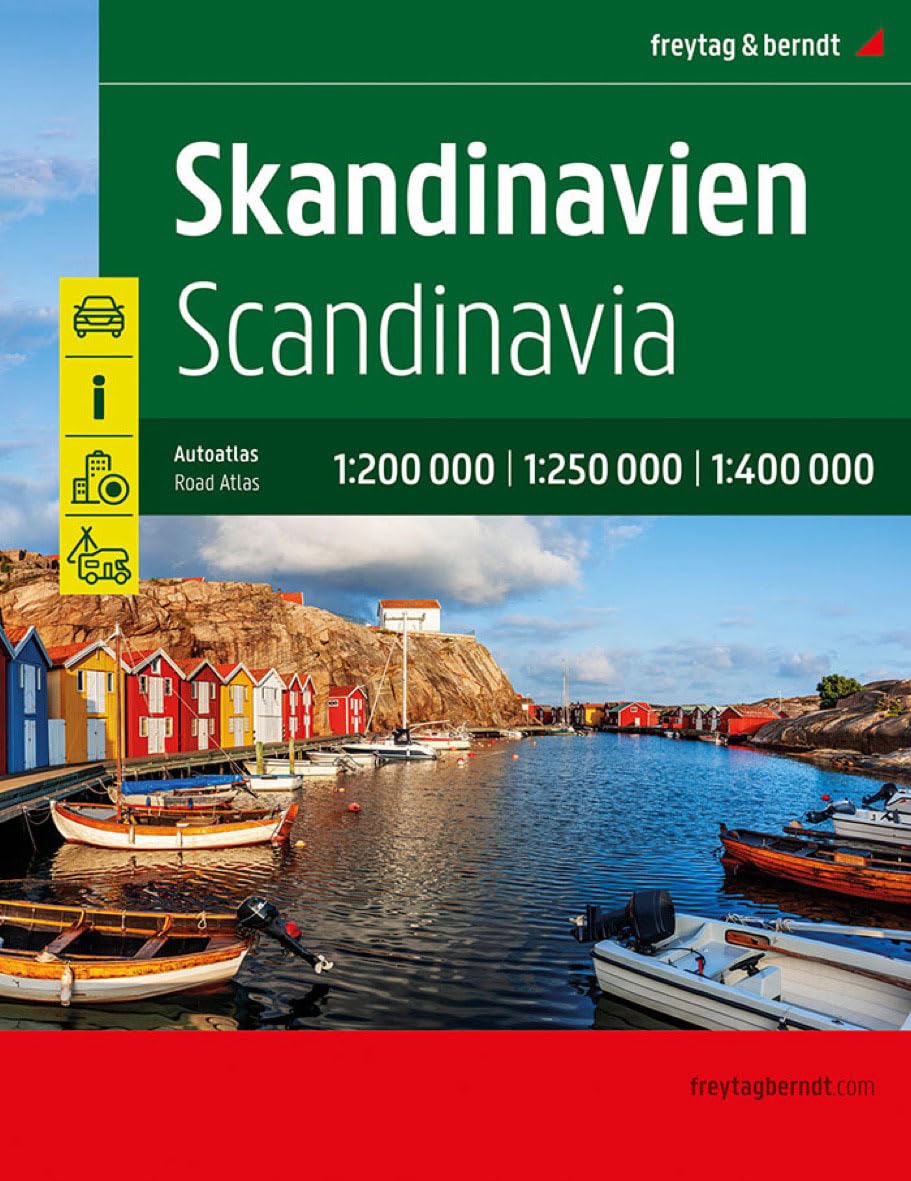
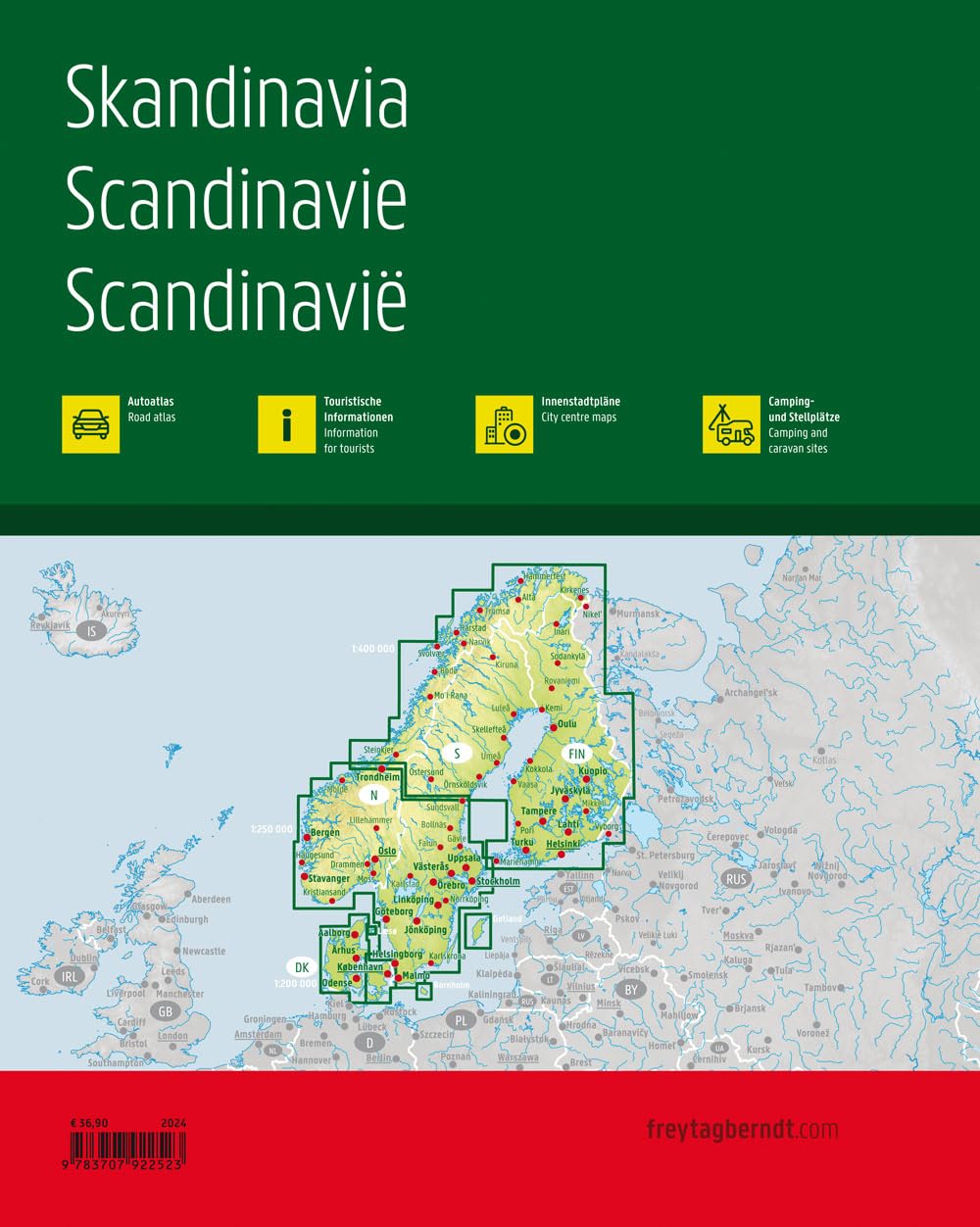
Ordinær pris 299,00 krSkandinavia
Ordinær pris 499,00 krVeiatlas over Skandinavia fra Freytag & Berndt.
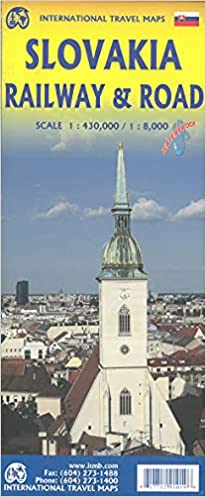
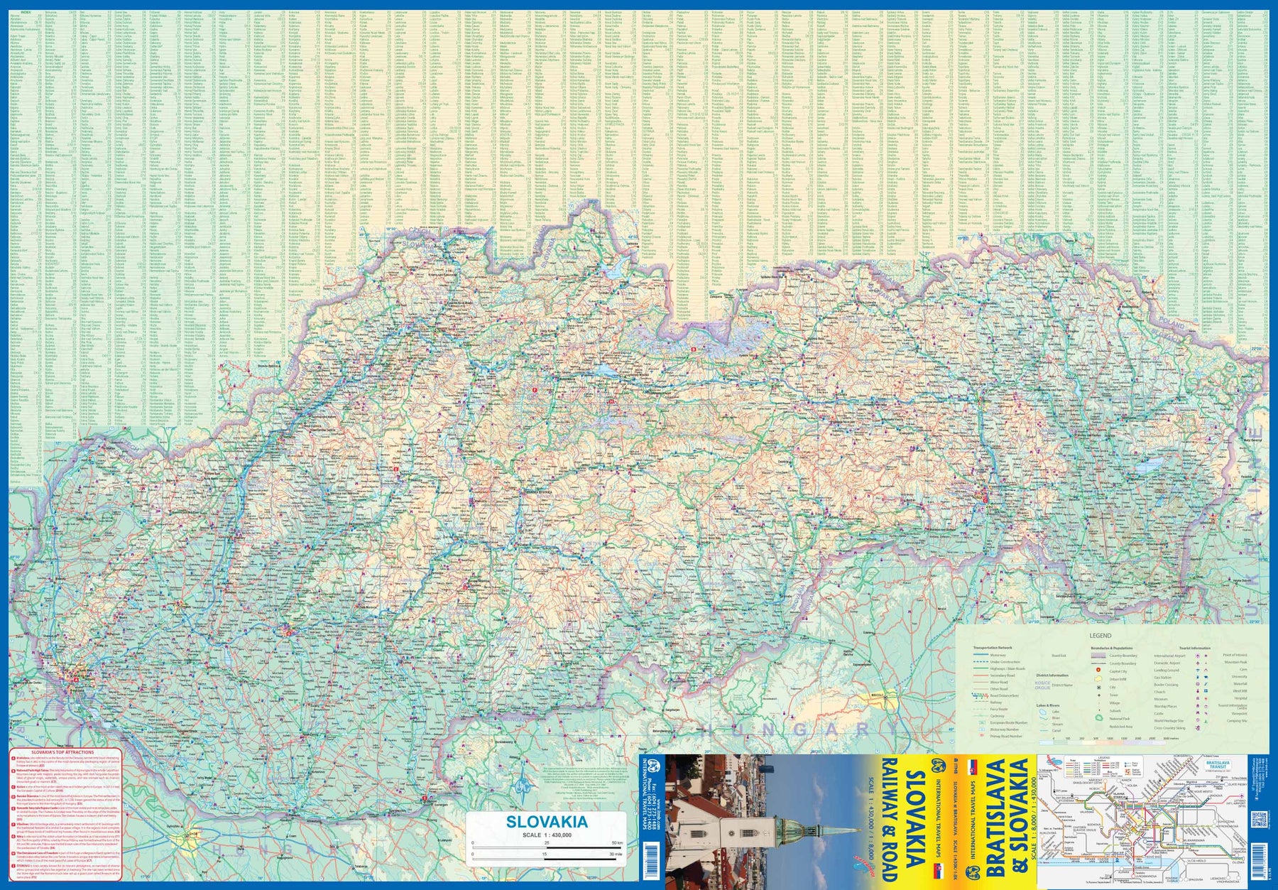
Slovakia - Railway & Road
Ordinær pris 169,00 krAs tourism to the eastern reaches of Europe becomes more popular, Slovakia is well-positioned to present an attractive opportunity for exploration. ITMB previously included this country with adjacent Hungary, but now we have expanded coverage and included a detailed map of Bratislava (1:8.000). Side 1 (1:430.000) shows the elongated country from its Austrian and Czech borders to its increasingly important border with Ukraine. As usual, we have included a listing of Top Attractions, such as the little-known towns of Kosice, Banska Stiavnica, and Sturovo, as well as the karst underground caves of Demanova and the fairy tale castle of Bojnice.
Side 2 portrays the capital city of Bratislava in excellent detail, showing the Danube River and the old town in great detail, along with the newer outlying areas of Petrzalka and Ruzinov. The map is printed on waterproof stone paper for durability. Legend Includes: Roads by classification, Rivers and Lakes, National Park, Airports, Points of Interests, Highways, Main Roads, Zoos, Fishing, and much more...
Slovenia
Ordinær pris 199,00 krlovenia at 1:185,000 on a light, waterproof and tear-resistant, indexed road map with topographic and tourist information, published by Reise Know-How as part of their highly acclaimed World Mapping Project. The map is double-sided, dividing the country west / east, to provide the best balance between a good scale and a convenient size sheet.
Road and rail networks are easy to see on a clear base which presents topography by altitude colouring with contours, spot heights, mountain passes and names of mountain ranges. Road network includes unsurfaced local roads and tracks, and shows driving distances on main and secondary roads. National parks and protected areas are marked and symbols highlight various places of interest, including different types of accommodation (campsites, youth hostels, selected inns and hotels, mountain refuges) archaeological remains, castles and churches, museums, viewpoints, spas, golf courses, wildlife parks, etc. The map has a latitude and longitude grid at intervals of 10’, UTM margin ticks, and an extensive index of localities. Map legend includes English.
Slovenia & Istria
Ordinær pris 199,00 krMarco Polo Slovenia and Istria Map: the ideal map for your trip. Let the Marco Polo Slovenia and Istria Road Map guide you around this stunning region. It folds away easily and is always on standby to help when you're stuck. Perfect touring map - the scale is 1 : 250 000 ideal to help you tour the country by car or campervan. Easy to use - the superbly clear mapping in strong colours and easy to read text will help you navigate the country like a local. Durable, tear-resistant map - designed to withstand the rigors of the road, the map is printed on tear-resistant, water repellent and writeable paper. Highlights included - major sights and key points of interest are marked on the map by numbered stars.
Lonely Planet Spain
Ordinær pris 119,00 krLonely Planet Planning Map er slitesterkt og vanntett, med en hendig slipcase og et format som er enkelt å brette. Få mer ut av kartet og reisen din med bilder og informasjon om toppattraksjoner i landet, reiseruteforslag, en transportguide, planleggingsinformasjon, temalister og praktiske reisetips. Med dette brukervennlige navigasjonsverktøyet i baklommen kan du virkelig komme til hjertet av din destinasjon!
Spain & Portugal & Andorra
Ordinær pris 169,00 krMarco Polo Spain and Portugal Map: the ideal map for your trip. Let the Marco Polo Spain and Portugal Road Map guide you around these wonderful countries. Explore Spain and Portugal's highways and byways with this highly durable, detailed, touring map. It folds away easily and is always on standby to help when you're stuck.
Spain: Balearics - Mallorca; Ibiza & Menorca
Ordinær pris 199,00 krThe Balearic Islands in the western Mediterranean have been extremely popular travel destinations for centuries. Mallorca/Majorca and Ibiza have become favoured visits by cruise ships to these islands in recent years, but the warm climate has attracted visitors for a long time. Side 1 concentrates on the three major islands of Mallorca, Ibiza, and Menorca but includes the smaller islands of Formentera and Cabrera, along with an inset map showing the islands in relation to the Spanish mainland ports of Valencia and Barcelona. Side 2 focusses on cruising the entire western half of the Mediterranean, from Naples west to Gibraltar. Naturally, the Balearics end up right in the centre of the map, which also includes the islands of Corsica and Sardinia, both of which are becoming increasingly popular with those cruising. I hasten to add that cruising is the fastest growing segment of the entire travel industry, so is an important market for the mapping industry.
Spain: Fuerteventura
Ordinær pris 199,00 krThis detailed recto/verso road map of Fuerteventura is very suitable for planning and traveling around the country. The road network is well represented, both the main roads, provincial and local roads. Road numbers are also clearly stated. Distances between places are marked on the map in kilometers, and gas stations are also marked in important places.
Shadow shows the relief and sometimes some points with the actual height. Province borders, national parks and reserves are easy to find. Symbols indicate the location of tourist sites, monuments, historically important places and viewpoints. In certain places you can find hotels and campsites, airports, train connections and ports.
Spain: La Palma
Ordinær pris 169,00 krDette store østerriske kartforlaget er kjent for sin klare kartografi og gode papirkvalitet. De kommer i alle målestokker, og flere av landkartene inneholder bykart og turistinformasjon.
Clear road map of La Palma from Freytag & Berndt showing its road network with main places of interest and hiking trails, plus street plans of Santa Cruz de la Palma, Los Cancajos, Puerto Naos and Los Llanos de Ariadne.
Publisert år: 2024
Innbinding: falset
Material: papir
Målestokk: 1:40000
Spain: Lanzarote
Ordinær pris 199,00 krDette store østerriske kartforlaget er kjent for sin klare kartografi og gode papirkvalitet. De kommer i alle målestokker, og flere av landkartene inneholder bykart og turistinformasjon.
Spain: Mallorca
Ordinær pris 199,00 krMajorca at 1:50,000 on a large, double-sided, contoured map from Freytag & Berndt, with highlighting for scenic roads and tourist routes, plus a booklet with a GPS-annotated index, street plan of central Palma, and multilingual descriptions of the island’s best sights.
St. Hanshaugen 1921
Ordinær pris 1.100,00 krDette kartet er kun tilgjengelig for kjøp i nettbutikken. Kartet printes når du kjøper, og har derfor noe lengre leveringstid.
Dette er Dapa Maps' utsnitt over deler av St. Hanshaugen fra kartet Kristiania 1921.
Oslos peneste kart? Ja det mener vi. I flere år har Dapa Maps sett på dette kartet og tenkt at de må gjøre med det. Vinteren 2023/2024 har de gjort en digital restaurering av kartet og kan nå vise det frem for allmenheten.
Kartet er opprinnelig tegnet av Byens Oppmaalingsvesen (forløper til Plan- og bygningsetaten) i 1921. Kartet ble da tegnet på 6 ulike kartblad som finnes arkivert hos Byarkivet.
Det Dapa Maps har gjort er å sette kartet sammen til et kart og redigert bort rutenettet slik at lesbarheten blir bedre. De har ikke endret noe på fargene eller på noen andre detaljer.
Dapa Maps
Kartet er laget av Daniel og Pavel fra Dapa Maps. De er to kartografer som tror at livet er best ute, derfor er de opptatt av å lage de peneste kartene de kan for at du kan bli kjent med områdene du liker best. Om du ønsker kan du lese mer om de her.
For hvert kart som selges planter de et tre slik at verden blir litt grønnere 🌳
Ramme og montering
Dapa Maps har endelig funnet frem til den perfekte rammen og kan nå tilby ramme og montering av kartet.
Lonely Planet Stockholm
Ordinær pris 119,00 krLonely Planet City Map er slitesterkt og vanntett, med en hendig slipcase og et format som er lett å brette. Få mer ut av kartet og reisen din med bilder og informasjon om byattraksjoner, transportkart, reiseruteforslag, omfattende gate- og nettstedsindeks og praktiske reisetips. Med dette brukervennlige navigasjonsverktøyet i baklommen kan du virkelig komme til hjertet av din destinasjon!
Street Map: Bruges
Ordinær pris 149,00 krDiscover Bruges by foot, car or bike using Michelin Bruges City Plan (scale 1/12,500 cm). In addition to Michelin's clear and accurate mapping, this city plan will help you explore and navigate across Bruges different districts thanks to its full index, its comprehensive key showing places of interest and tourist attractions, as well as practical information on public transport leisure facilities, service stations and shops!Discover the new range of Michelin City Maps* Write on Wipe off ,Draw your route with a felt tipped pen, Erase with a damp cloth!* Plastic Format* Durable and convenient to use* Handy Compact, folds "free" for easy handling* Clarity and legibility of Michelin mapping:* Map of the city centre with identified tourist sites* Green Guide tourist sites* Smaller Map of whole city* Underground Map, with a detailed index.
Publisert år: 2020
Innbinding: Falset
Material: Plast
Målestokk: 1:12,500
Street Map: Moscow
Ordinær pris 149,00 krDiscover Moscow by foot, car or bike using Michelin Moscow City Plan (scale 1/12,500 cm). In addition to Michelin's clear and accurate mapping, this city plan will help you explore and navigate across Moscow different districts thanks to its full index, its comprehensive key showing places of interest and tourist attractions, as well as practical information on public transport leisure facilities, service stations and shops!Discover the new range of Michelin City Maps* Write on Wipe off, Draw your route with a dry marker tipped pen, Erase with a damp cloth!* Plastic Format* Durable and convenient to use* Handy Compact, folds "free" for easy handling* Clarity and legibility of Michelin mapping:* Map of the city centre with identified tourist sites* Green Guide tourist sites* Smaller Map of whole city* Underground Map, with a detailed index.
Publisert år: 2019
Innbinding: Falset
Material: Plast
Målestokk: 1:12,500
Street Map: St. Petersburg
Ordinær pris 149,00 krDiscover Saint Petersburg by foot, car or bike using Michelin Saint Petersburg City Plan (scale 1/12,500 cm). In addition to Michelin's clear and accurate mapping, this city plan will help you explore and navigate across Saint Petersburg different districts thanks to its full index, its comprehensive key showing places of interest and tourist attractions, as well as practical information on public transport leisure facilities, service stations and shops!Discover the new range of Michelin City Maps* Write on Wipe off ,Draw your route with a felt tipped pen, Erase with a damp cloth!* Plastic Format* Durable and convenient to use* Handy Compact, folds "free" for easy handling* Clarity and legibility of Michelin mapping:* Map of the city centre with identified tourist sites* Green Guide tourist sites* Smaller Map of whole city* Underground Map, with a detailed index.
Publisert år: 2020
Innbinding: Falset
Material: Plast
Målestokk: 1:12,500
Sunnmørsalpene
Ordinær pris 249,00 krSunnmørsalpene er et av de vakreste fjellandskapene i Norge. Her finner du krevende randonee - klassikere som Slogen, Randers Topp og Kolåstinden. Det er dramatisk og luftig - fjellene stuper gjerne rett ned i fjorden og gir en følelse av skikkelig høyfjell ulikt det meste av Norge.
Tyvek er et spesielt materiale som oprinnelig kommer fra bygg- og anleggsbransje. Det er basert på en form for vevde plast-tråder som gjør det ekstremt slitesterkt! Kartene våre er trykket på Tyvek. De er fullt lesbare og brukbare, men de er også helt umulig å rive, krølle eller bløte til. Tyvek er vannresistent, og selv når det blir vått vil det ikke bli ødelagt som alminnelige papirkart. Dette er en egenskap alle kartene fra Fri Flyt og Calazo har!
Sweden
Ordinær pris 189,00 krMarco Polo er svært detaljerte kart som er praktiske og enkle i bruk. 7 klistremerker for å markere spesifikke steder gjør det enda enklere å planlegge reisen. Alle kartene inneholder en omfattende index for enkelt å finne frem.
Sweden: South
Ordinær pris 199,00 krHighly tear-resistant and 100% waterproof map "Sweden, South" from the series world mapping project.
Travel know-how maps are characterized by particularly sturdy plastic paper, which can be written on like paper, even with a pencil. The cardboard envelope is removable, making it easy to put the card in any pocket. A protective cover is not required. The cartographic representation focuses on the most important information for travelers and is particularly easy to read. Instead of shading, colored layers of elevation are used.
Sykkelkart 2 - Sydlige Sjælland
Ordinær pris 249,00 kr