1760 produkter
1760 produkter
1760 produkter
Spain: Balearics - Mallorca; Ibiza & Menorca
Ordinær pris 199,00 krThe Balearic Islands in the western Mediterranean have been extremely popular travel destinations for centuries. Mallorca/Majorca and Ibiza have become favoured visits by cruise ships to these islands in recent years, but the warm climate has attracted visitors for a long time. Side 1 concentrates on the three major islands of Mallorca, Ibiza, and Menorca but includes the smaller islands of Formentera and Cabrera, along with an inset map showing the islands in relation to the Spanish mainland ports of Valencia and Barcelona. Side 2 focusses on cruising the entire western half of the Mediterranean, from Naples west to Gibraltar. Naturally, the Balearics end up right in the centre of the map, which also includes the islands of Corsica and Sardinia, both of which are becoming increasingly popular with those cruising. I hasten to add that cruising is the fastest growing segment of the entire travel industry, so is an important market for the mapping industry.
Spain: Fuerteventura
Ordinær pris 199,00 krThis detailed recto/verso road map of Fuerteventura is very suitable for planning and traveling around the country. The road network is well represented, both the main roads, provincial and local roads. Road numbers are also clearly stated. Distances between places are marked on the map in kilometers, and gas stations are also marked in important places.
Shadow shows the relief and sometimes some points with the actual height. Province borders, national parks and reserves are easy to find. Symbols indicate the location of tourist sites, monuments, historically important places and viewpoints. In certain places you can find hotels and campsites, airports, train connections and ports.
Spain: Gran Canaria
Ordinær pris 199,00 krDette store østerriske kartforlaget er kjent for sin klare kartografi og gode papirkvalitet. De kommer i alle målestokker, og flere av landkartene inneholder bykart og turistinformasjon.
Spain: La Palma
Ordinær pris 169,00 krDette store østerriske kartforlaget er kjent for sin klare kartografi og gode papirkvalitet. De kommer i alle målestokker, og flere av landkartene inneholder bykart og turistinformasjon.
Clear road map of La Palma from Freytag & Berndt showing its road network with main places of interest and hiking trails, plus street plans of Santa Cruz de la Palma, Los Cancajos, Puerto Naos and Los Llanos de Ariadne.
Publisert år: 2024
Innbinding: falset
Material: papir
Målestokk: 1:40000
Spain: Lanzarote
Ordinær pris 199,00 krDette store østerriske kartforlaget er kjent for sin klare kartografi og gode papirkvalitet. De kommer i alle målestokker, og flere av landkartene inneholder bykart og turistinformasjon.
Spain: Mallorca
Ordinær pris 199,00 krMajorca at 1:50,000 on a large, double-sided, contoured map from Freytag & Berndt, with highlighting for scenic roads and tourist routes, plus a booklet with a GPS-annotated index, street plan of central Palma, and multilingual descriptions of the island’s best sights.
Spain: Mediterranean Coast
Ordinær pris 199,00 krSpain is one of the most popular travel destinations in Europe. The country is extremely diverse, reflecting its history. The coastal areas of the Mediterranean were probably first settled by Phoenicians, then Greeks, then Romans, and then Arabs before being brought into a united Spain at the time Columbus was seeking a sponsor to fund his proposed journey to discover new lands to the west. This map focuses on the coast from the French border south through Catalunya all the way to the Straits of Gibraltar and Cadiz. The offshore islands of Mallorca, Ibiza, and Menorca are included, as is the North African Spanish enclave of Ceuta and the British enclave of Gibraltar.
All road and rail lines are shown, including the new Cadiz to Madrid fast train. By the nature of mapping, a considerable amount of the interior is on the map as well, so this map is much more than just a coastal journey through Valencia and Murcia to reach Granada, although that would be a very enjoyable trip. The map is equally applicable to interior trips to Cordoba or Albacete as it is a map of the coast. However, its purpose is to show the attractions of the coast – beaches, resort areas, historic towns, forts, nature reserves, archaeological remains, and Top Attractions.
Spitsbergen Nordre del
Ordinær pris 169,00 krSt. Hanshaugen 1921
Ordinær pris 1.100,00 krDette kartet er kun tilgjengelig for kjøp i nettbutikken. Kartet printes når du kjøper, og har derfor noe lengre leveringstid.
Dette er Dapa Maps' utsnitt over deler av St. Hanshaugen fra kartet Kristiania 1921.
Oslos peneste kart? Ja det mener vi. I flere år har Dapa Maps sett på dette kartet og tenkt at de må gjøre med det. Vinteren 2023/2024 har de gjort en digital restaurering av kartet og kan nå vise det frem for allmenheten.
Kartet er opprinnelig tegnet av Byens Oppmaalingsvesen (forløper til Plan- og bygningsetaten) i 1921. Kartet ble da tegnet på 6 ulike kartblad som finnes arkivert hos Byarkivet.
Det Dapa Maps har gjort er å sette kartet sammen til et kart og redigert bort rutenettet slik at lesbarheten blir bedre. De har ikke endret noe på fargene eller på noen andre detaljer.
Dapa Maps
Kartet er laget av Daniel og Pavel fra Dapa Maps. De er to kartografer som tror at livet er best ute, derfor er de opptatt av å lage de peneste kartene de kan for at du kan bli kjent med områdene du liker best. Om du ønsker kan du lese mer om de her.
For hvert kart som selges planter de et tre slik at verden blir litt grønnere 🌳
Ramme og montering
Dapa Maps har endelig funnet frem til den perfekte rammen og kan nå tilby ramme og montering av kartet.
Stikart: Trondheim & Malvikmarka
Ordinær pris 229,00 krTrondheim, Malvik og Stjørdal er omkranset av flotte friluftsområder for turer i skogen, på fjellet og ved sjøen hele året. Dette kartet viser de mange mulighetene og den store variasjonen for et bynært friluftsliv.
I Bymarka så vel som i Mostadmarka, Jonsvannsmarka og i Malvikmarka er det stier og skispor på kryss og tvers, oppkjørte skiløyper om vinteren og godt merka turruter for sommeren. Pilegrimsledene kommer fra alle himmelretninger og peker mot Nidarosdomen. Godt inntegnet på kartet er bl.a. også badeplasser, rekreasjonsområder med universell utforming og populære toppturer og utsiktspunkter.
Kartet Trondheim og Malvikmarka er utgitt av Calazo förlag, etter innspill fra sentrale tur- og friluftlivsaktører i regionen. Dette er en del av en moderne kartserie der terrenginformasjonen er basert på laserskanning fra fly, noe som gir stor detaljrikdom med et nesten tredimensjonalt inntrykk. Kartet har med alle merkede turruter, skiløyper, badeplasser og kajakkutleie i hele dekningsområdet, og er beregnet på helårsbruk.
Stockholm
Ordinær pris 99,00 krKart i postkortstørrelse. Folder seg ut som en popoutbok når du åpner dem. Fargerik turistinformasjon med kart over metro og busstraseer, landemerker og lignende. Veldig enkelt å håndtere.
Stockholm
Ordinær pris 119,00 krLonely Planet City Map er slitesterkt og vanntett, med en hendig slipcase og et format som er lett å brette. Få mer ut av kartet og reisen din med bilder og informasjon om byattraksjoner, transportkart, reiseruteforslag, omfattende gate- og nettstedsindeks og praktiske reisetips. Med dette brukervennlige navigasjonsverktøyet i baklommen kan du virkelig komme til hjertet av din destinasjon!
Stockholm
Ordinær pris 149,00 krFolded street and travel map in colour. Scale 1:15,000. Legend includes sights, museums, monuments, churches, synagogues, monasteries, castles, windmills, beaches, golf courses, parking, youth hostels, car ferries, airfields, subway, commuter train, camping sites, viewpoints, hotels.
Street Map: Bruges
Ordinær pris 149,00 krDiscover Bruges by foot, car or bike using Michelin Bruges City Plan (scale 1/12,500 cm). In addition to Michelin's clear and accurate mapping, this city plan will help you explore and navigate across Bruges different districts thanks to its full index, its comprehensive key showing places of interest and tourist attractions, as well as practical information on public transport leisure facilities, service stations and shops!Discover the new range of Michelin City Maps* Write on Wipe off ,Draw your route with a felt tipped pen, Erase with a damp cloth!* Plastic Format* Durable and convenient to use* Handy Compact, folds "free" for easy handling* Clarity and legibility of Michelin mapping:* Map of the city centre with identified tourist sites* Green Guide tourist sites* Smaller Map of whole city* Underground Map, with a detailed index.
Publisert år: 2020
Innbinding: Falset
Material: Plast
Målestokk: 1:12,500
Street Map: Moscow
Ordinær pris 149,00 krDiscover Moscow by foot, car or bike using Michelin Moscow City Plan (scale 1/12,500 cm). In addition to Michelin's clear and accurate mapping, this city plan will help you explore and navigate across Moscow different districts thanks to its full index, its comprehensive key showing places of interest and tourist attractions, as well as practical information on public transport leisure facilities, service stations and shops!Discover the new range of Michelin City Maps* Write on Wipe off, Draw your route with a dry marker tipped pen, Erase with a damp cloth!* Plastic Format* Durable and convenient to use* Handy Compact, folds "free" for easy handling* Clarity and legibility of Michelin mapping:* Map of the city centre with identified tourist sites* Green Guide tourist sites* Smaller Map of whole city* Underground Map, with a detailed index.
Publisert år: 2019
Innbinding: Falset
Material: Plast
Målestokk: 1:12,500
Street Map: Prague
Ordinær pris 149,00 krDiscover Prague by foot, car or bike using Michelin Prague City Plan (scale 1/15,000 cm). In addition to Michelin's clear and accurate mapping, this city plan will help you explore and navigate across Prague' different districts thanks to its full index, its comprehensive key showing places of interest and tourist attractions, as well as practical information on public transport leisure facilities, service stations and shops!Discover the new range of Michelin City Maps* Write on Wipe off ,Draw your route with a felt tipped pen, Erase with a damp cloth!* Plastic Format* Durable and convenient to use* Handy Compact, folds "free" for easy handling* Clarity and legibility of Michelin mapping:* Map of the city centre with identified tourist sites* Green Guide tourist sites* Smaller Map of whole city* Underground Map, with a detailed index.
Publisert år: 2017
Innbinding: Falset
Material: Plast
Målestokk: 1:12,500
Street Map: St. Petersburg
Ordinær pris 149,00 krDiscover Saint Petersburg by foot, car or bike using Michelin Saint Petersburg City Plan (scale 1/12,500 cm). In addition to Michelin's clear and accurate mapping, this city plan will help you explore and navigate across Saint Petersburg different districts thanks to its full index, its comprehensive key showing places of interest and tourist attractions, as well as practical information on public transport leisure facilities, service stations and shops!Discover the new range of Michelin City Maps* Write on Wipe off ,Draw your route with a felt tipped pen, Erase with a damp cloth!* Plastic Format* Durable and convenient to use* Handy Compact, folds "free" for easy handling* Clarity and legibility of Michelin mapping:* Map of the city centre with identified tourist sites* Green Guide tourist sites* Smaller Map of whole city* Underground Map, with a detailed index.
Publisert år: 2020
Innbinding: Falset
Material: Plast
Målestokk: 1:12,500
Sunnmørsalpene
Ordinær pris 249,00 krSunnmørsalpene er et av de vakreste fjellandskapene i Norge. Her finner du krevende randonee - klassikere som Slogen, Randers Topp og Kolåstinden. Det er dramatisk og luftig - fjellene stuper gjerne rett ned i fjorden og gir en følelse av skikkelig høyfjell ulikt det meste av Norge.
Tyvek er et spesielt materiale som oprinnelig kommer fra bygg- og anleggsbransje. Det er basert på en form for vevde plast-tråder som gjør det ekstremt slitesterkt! Kartene våre er trykket på Tyvek. De er fullt lesbare og brukbare, men de er også helt umulig å rive, krølle eller bløte til. Tyvek er vannresistent, og selv når det blir vått vil det ikke bli ødelagt som alminnelige papirkart. Dette er en egenskap alle kartene fra Fri Flyt og Calazo har!
Sverige (Sweden)
Ordinær pris 199,00 krSweden: South
Ordinær pris 199,00 krHighly tear-resistant and 100% waterproof map "Sweden, South" from the series world mapping project.
Travel know-how maps are characterized by particularly sturdy plastic paper, which can be written on like paper, even with a pencil. The cardboard envelope is removable, making it easy to put the card in any pocket. A protective cover is not required. The cartographic representation focuses on the most important information for travelers and is particularly easy to read. Instead of shading, colored layers of elevation are used.
Switzerland
Ordinær pris 199,00 krPerfect touring map - the scale is 1 : 275 000 ideal to help you tour the region by car or campervan. Easy to use - the superbly clear mapping in strong colours and easy to read text will help you navigate the country like a local. Durable, tear-resistant map - designed to withstand the rigors of the road, the map is printed on tear-resistant, water repellent and writeable paper.
Sykkelkart 1 - Nordlige Sjælland
Ordinær pris 249,00 krThe maps contain: National cycle routes Regional cycle routes Local cycle routes, including the beautiful panorama routes. General information about accommodation, bike inclusion on trains etc. -Information icons on the map: Grocery stores outside major city, Tourist offices, National attractions, UNESCO world heritage, Bicycle friendly churches (special place for bike parking, water bottle filling etc., and a bicycle pump is available), Bike retailers, Beaches, Campsites, Hotels / Inns, Resting places, Hostels, Tent camps Ferry routes List of content is written in Danish, German and English.
Sykkelkart 2 - Sydlige Sjælland
Ordinær pris 249,00 krSykkelkart 3 - Fyn
Ordinær pris 249,00 krSykkelkart 4 - Østlige Jylland
Ordinær pris 249,00 krSykkelkart 6 - Vestlige Jylland
Ordinær pris 249,00 kr
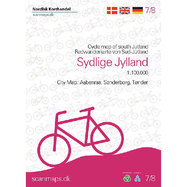
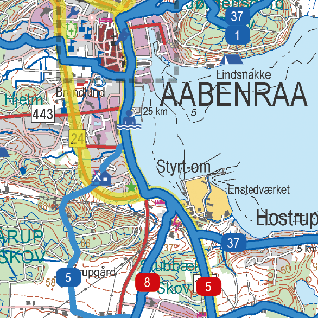
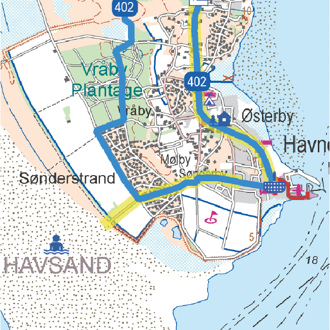
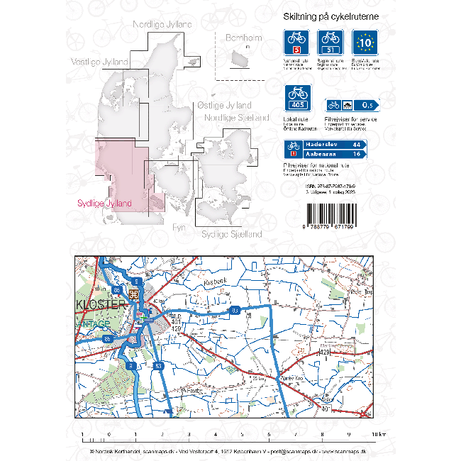
Sykkelkart 7 - Sydlige Jylland
Ordinær pris 249,00 krSykkelkart Danmark
Ordinær pris 249,00 krThe map of Denmark in the 4th edition now has bicycle maps on both sides of the map. In addition to the map of Denmark at a scale of 1: 500,000, you also get a bicycle map of Greater Copenhagen at a scale of 1: 35,000.
The map of Denmark contains a lot of information that is indispensable for a cycling holiday in Denmark. The map shows national and regional cycle routes, roads with cycle paths, hostels, campsites, tourist information, etc., and a Eurovelo map of the routes that run through Denmark is drawn. Information about the Danish cycling rules is included. There are over 160 regional and 11 national routes on the map, and new routes include the Culture Ring (East Jutland) and the West Region Route (Copenhagen).
The bicycle map is a planning map that provides an overview of cycling opportunities.
On the other side of the map you have a map of Greater Copenhagen at a scale of 1: 35,000, which is a detailed map of Copenhagen's cycle paths and cycle routes.