6 produkter
Antarctica & Tierra del Fuego
Ordinær pris 189,00 krITM har kart over hele verden og de spesialiserer seg på land litt utenfor allfarvei. Beliggenheten til landets nasjonalparker, historiske monumenter, de viktigste veiene o.L. Finner du inkludert i kartene. Samtlige landkart har ofte et bykart over hovedstaden.
Fra ITM: Antarctica remains one of the most fascinating places on earth. It is possible to visit the continent during the ‘summer’ months of January/February, by ship. This5th edition has Antarctica on one side and Tierra del Fuego on the other, since most ships heading across the Drake Passage originate in Ushuaia, Argentina. This edition is also unique in that we portray loss of permanent ice since the last edition. Global warming is melting the ice cover quite quickly, both visibly above the surface and by warmer ocean currents melting the underside of ice shelves. This should cause a carving off of a huge piece of ice in the near future that is about the size of Prince Edward Island in Canada. Scale 1:7 mill. Printed on waterproof paper. Legend includes: International Date Line, Trans-Antarctic Expedition, Amundsen 1911, Scot 1911-12, Point of Interest, Mountain Peak, Volcano, Closest Approach to Continent by Cook., Island covered by Ice shelf, Ice shelf, Ice rise on ice shelf, Ice melted or calved, Glacier, Melted Glacier for Antarctica, Road Number, International Boundary, Administrative Boundary, Main Highway, Paved, Main Road, Pabed, Secondary Road, Other Road Trail/Track Road, Railway, Timezone, Ferry Route, Rivers, Seasonal Rivers, Lake, Swamp, Glacier, Sand pan, Park and much more...
Publisert år: 2017
Innbinding: falset
Material: Papir
Målestokk: 1:8000000
Argentina: Buenos Aires & Northeast
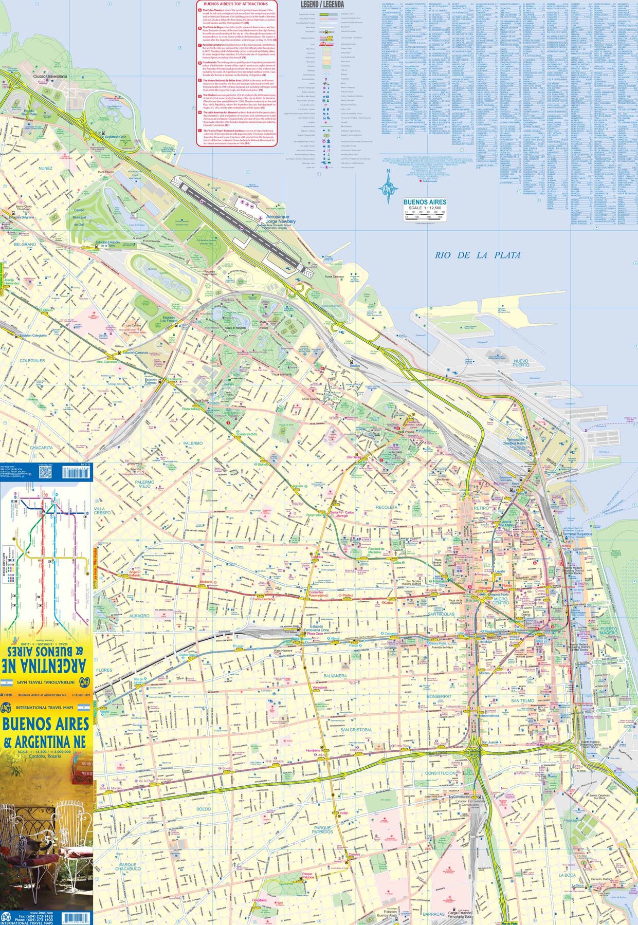
Ordinær pris 199,00 krThis version represents a thorough updating of this important Argentinean city. The subway lines are now clearly shown and the main shopping/pedestrian ways more clearly delineated. All three railway stations are shown, although rail services have largely been curtailed except for suburban usage. The cruise ship terminal has been added and the ferry crossing to Uruguay moved. La Recoleta cemetery has had pathways noted. The airport shown is only used for local flights, as the main international airport is quite far away from the city. 
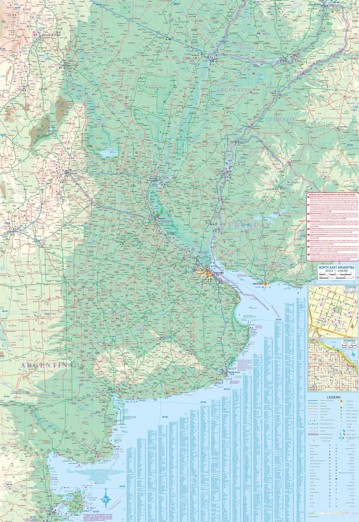
It is noted on the second side of the map, which covers all of northeastern Argentina, most of Uruguay, and small portions of Brazil and Paraguay. No visit to Argentina would be complete without including Iguazu Falls or historic Cordoba, which are on this map. The regional map goes as far south as Puerto Madryn and includes such popular destinations as Bahia Blanca and Mar del Plata. Insets of Cordoba and Rosario are included.
- Publisert: 2024
- Innbinding: Falset
- Materiale: Vanntett papir
- Målestokk: 1:12 500, 1:2 000 000
Chile: South & Patagonia
Ordinær pris 199,00 kr- Publisert: 2019
- Innbinding: Falset
- Materiale: Papir
- Målestokk: 1:1:770,000, / 2,200,000
Patagonia Rail & Road
Ordinær pris 189,00 krITM har kart over hele verden og de spesialiserer seg på land litt utenfor allfarvei. Beliggenheten til landets nasjonalparker, historiske monumenter, de viktigste veiene og lignende finner du inkludert i kartene. Samtlige landkart har ofte et bykart over hovedstaden.
Fra ITM: Patagonia has changed dramatically in recent years. Argentina has finally invested in infrastructural improvements to make the region more accessible by paving roads, upgrading airports, building hospitals, encouraging tourism, and making exploration much more pleasant than when I first visited the region. By the shape of the southern third of South America, the map is best shown with the northern portion of Patagonia on one side and goes to the north of what is traditionally thought of as Patagonia to include the La Pampa region and Buenos Aires at the northernmost upper area of the map. As a result, all of Chile south of Conception is also shown. Highway 40, the 'spinal cord' of Patagonia, is now paved, or mostly so, making driving reasonably easy. There are rail lines in this northern region, and we have shown them, but I believe that all passenger service has been discontinued. The second side covers the Santa Cruz grasslands, the wonderful Chilean southern islands, and the very popular Tierra del Fuego portion of both countries. Most people do not realize that the Tierra region is an island, with access controlled by a Chilean ferry and border crossings into the Argentinian portion. Ushuaia, the most important city, is actually in the southern shore of the island, fronting on to the Beagle Channel. The southernmost point in South America is an island named after Hoorn, in old Holland, called Cape Horn in English. We even show the route tour boats use to get to Cape Horn from Ushuaia. The Falkland Islands are close enough to this southern tip of the continent to show on this map, and we have also included an expanded inset map to show the British colony in better detail. Just don't try to get there from Argentina! We have also included a detailed inset map of Ushuaia.
- Publisert: 2023
- Innbinding: Falset
- Materiale: Vanntett Papir
- Målestokk: 1:2 000 000
South America
Ordinær pris 249,00 krITM har kart over hele verden og de spesialiserer seg på land litt utenfor allfarvei. Beliggenheten til landets nasjonalparker, historiske monumenter, de viktigste veiene og lignende finner du inkludert i kartene. Samtlige landkart har ofte et bykart over hovedstaden.
Fra ITM: South America as a continent is fascinating. For many years, ITMB has provided this map, either in its original version of two single sided map or a double sided map, such as this. We spent a lot of time reviewing the artwork and updating information from more detailed maps. The resulting map is a considerable improvement on the previous edition. The print is remarkable clear and easy to read. Road categories, road numbers of highways, parks, major history and touristic information have all been updated. This is a fascinating continent, and this map is the definitive map of the continent
- Publisert: 2019
- Innbinding: Falset
- Materiale: Papir
- Målestokk: 1:4 000 000
The Andes
Ordinær pris 199,00 krWe are pleased to be able to re-introduce this important title into our publishing range after a lapse caused by Covid. The Andes mountain chain is the southern extension of the Sierra Nevada chain through Mexico and Central America, which is, in turn the southern extension of the Rocky Mountain chain from Alaska to the Mexican border. The Andes is a magnificent series of high mountains that enters Colombia and spreads southwards through Ecuador and Peru all the way to southern Patagonia.
The map is double-sided, with the Northern Andes on one side and the other side divided into two side-by-side maps portraying the Central Andes and the Southern Andes. Thus, the map coverage focuses on the Andes themselves, rather than on all of South America. All of Colombia and Peru are shown, most of Bolivia, all of Chile, and the Patagonian portion of Argentina except for the southern portion of Tierra del Fuego. The importance of this map is that it focuses on the highland areas of the continent, where much of the population lives. Bogota, Medellin, Quito, Lima, Arequipa, La Paz, Santiago, Talca, and Punta Arenas are all located along the spine of the Andes. So are the Torres del Paine peaks, the Montt Glacier, and numerous volcanoes, touristic sites, and twisting mountain roads.
- Publisert: 2022
- Innbinding: Falset
- Materiael: Papir
- Målestokk: 1:3 000 000