130 produkter
Chile: Easter Island & Santiago
Ordinær pris 199,00 kr4th edition 2015. Easter Island is so isolated that it is not certain whether it is part of Polynesia or an off-shoot of South America. Geologically, it is neither; just a volcanic lump in the vast expanse of the Pacific Ocean. Its original inhabitants probably came from Polynesia; since supplanted by migrants from Chile, which is the political authority governing the island. Regardless, it is an intriguing place, famous for the Maoi – giant heads originally raised to protect family holdings. These huge, mysterious heads rest in various locations on the island and are one of the wonders of the world.
This map also includes a detailed map of Santiago de Chile, the capital of Chile, for the simple reason that all flights to Easter Island originate in that city, so everyone going to Easter Island needs a map of Santiago as well. This usage is merely for the convenience of visitors going to Easter Island.
China: Hong Kong & Region
Ordinær pris 149,00 krITM har kart over hele verden og de spesialiserer seg på land litt utenfor allfarvei. Beliggenheten til landets nasjonalparker, historiske monumenter, de viktigste veiene o.L. Finner du inkludert i kartene. Samtlige landkart har ofte et bykart over hovedstaden.
Fra ITM: 4th edition 2016. Hong Kong is a double-sided map in scale 1:10.000/1:60.000, printed on waterproof paper.A street plan of Hong Kong with Kowloon at 1:10,000 and on the reverse a road map of the HK Special Administrative Region at 1:60,000, plus a diagram of the transport network. The street plan show Hong Kong and Kowloon at 1:10,000 with colouring for the main traffic arteries, very clear presentation of the highway junctions, and marking for one way streets. Where appropriate, MTR and KCR stations are shown with multiple entrances/exits, and the map also shows the double-decker tram line, the Mid-Levels Escalator and the ferry connections across the Victoria Harbour and Kowloon Bay. The plan also shows pedestrianized streets and those with staircases in the hilly part of the Hong Kong Island. Various places of interest and facilities are highlighted, including selected hotels. On the reverse is an indexed road map of the Hong Kong SAR at 1:60,000, extending north to Shenzehen. Altitude colouring shows the topography. Railway and ferry connections are marked and numerous places of interest are highlighted. On both sides place names are given in the Latin alphabet only, with on the road map selected location also shown in Chinese. The map includes a diagram of the transport network.
Publisert år: 2016
Innbinding: falset
Material: plastpapir
Målestokk: 1:10000/60000
China: South & Guangzhou
Ordinær pris 149,00 kr Salgspris 119,00 kr Spar 20%China, as a country, is very popular with travellers. However, China is also a very large geographical entity and showing the entire country on one map results in a scale that reduces the amount of information that can be shown. The most visited part of the country is the south, with rapid train access from Hong Kong and major airports at Guangzhou and Shanghai. Travel to China is also increasing as more international airports are opened.
The regional map covers one side of this double-sided map; the other contains an updated map of Guangzhou (formerly Canton). Lan and I visited this city in February and were surprised at how open and modern the city is. In comparison with Beijing, the political overtones are much reduced, and Sun Yat Sen is the hero. The city is also a major train hub, with two major stations handling traffic, and six bus stations arranging transportation to nearby cities.
Costa Rica
Ordinær pris 199,00 krThis is an ITMB title that is so popular it needs no explanation. This is the most recent edition of a tried-and true title that has been a mainstay of our Central American line since the early 1980s. Folded double-sided road map Inset maps: Central San Jose City, Environs of San Jose. List of Costa Rica's Top Attractions. Legend includes: Highways, roads, railways, lakes, rivers, national parks, hotels, gas stations, museums, beaches, waterfalls and more.
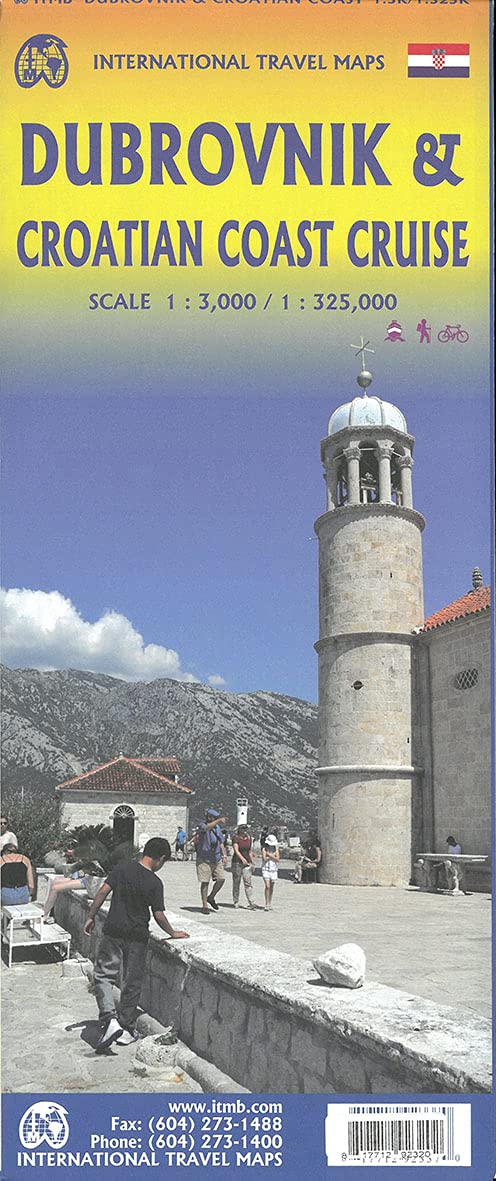
Croatia: Dubrovnik & Croatian Coast Cruise
Ordinær pris 199,00 krThe ancient port city of Dubrovnik, on the southern Croatian coastline, has evolved into a major tourist destination. The old walled city, normally entered through the famous Pile Gate, was so crowded with tourists when we arrived, that it took some time to get to the main street of Stradun. The city has completely recovered from the Montenegrin bombing during the breakup of Yugoslavia, with a few shellholes remaining just to show to tourists. The highlights of a visit are the Rector’s Palace, the Tvrdava fortress, and the cathedral. The map covers the urban area outside of the old town as well, as this is where most of the hotels and restaurants are located.
The other side of the map shows the extensive coastline of Croatia in two parts – from the Italian border to Trogir, and from Split to the border with Montenegro. We travelled from Porec to Dubrovnik in a small cruise ship of 45 passengers, which enabled us to visit ports that larger ships could not reach. As a result, we visited islands we could not have otherwise visited. The cover picture shows grandson Johnny in one such small town.
Dominica & Saint Lucia
Ordinær pris 149,00 krITM har kart over hele verden og de spesialiserer seg på land litt utenfor allfarvei. Beliggenheten til landets nasjonalparker, historiske monumenter, de viktigste veiene o.L. Finner du inkludert i kartene. Samtlige landkart har ofte et bykart over hovedstaden.
Fra ITM: The island is a popular holiday vacation destination and cruise ship stopover port. We have in reality placed two maps on the sheet, by adding St. Lucia, another popular Caribbean destination, to the reverse side. Each country is placed on one side of the paper, with insets of their respective capitals, Roseau and Castries. Dominica, with its rugged volcanic terrain, its dominating mountains, and its lush pristine rainforests, has a natural beauty that is a prime reason to visit and enjoy the island’s attractions.
In addition, both islands are linked to each other and to Martinique and Guadeloupe by new inter-island ferries. This new system of ferries is joining the islands together for sharing tourism, as well as economic cohesion within the Caribbean. It is now possible to base oneself on Dominica and enjoy day trips to Martinique, for example, or St. Lucia.
Publisert år: 2013
Innbinding: falset
Material: vanntett papir
Målestokk: 1:50,000 / 40,000
Dominican Republic & Haiti
Ordinær pris 149,00 krITM har kart over hele verden og de spesialiserer seg på land litt utenfor allfarvei. Beliggenheten til landets nasjonalparker, historiske monumenter, de viktigste veiene o.L. Finner du inkludert i kartene. Samtlige landkart har ofte et bykart over hovedstaden.
Fra ITM: We spent a week on the lovely island of Hispaniola, home to the Dominican Republic and Haiti, last December. We spent several days driving the highways, checking our information and this new edition is the result. Frankly, we were surprised how accurate the digital artwork was (and is); this is the first time that we have been able to ground-truth a map shortly before printing, and after updating. We did discover one new toll highway, and we learned that Santa Domingo floods rather easily during heavy rains. We now show a lot of what I would consider to be local farm roads; they exist, but it is doubtful any tourist would use them. We also discovered a new motorway-like highway that is under construction between Santiago and Puerto Plata, but we are leaving it off the map for now as work has just begun and we saw little indication that it would be completed. We can add it if we see progress. The Haiti side of the sheet remains a work in progress. There are now five border crossings with Dom Rep and a lot of cross-border traffic, but the road network in Haiti remains quite basic. We have added hundreds of small local roads to our artwork; most are simple dirt tracks. We have also added a series of top attractions for Haiti, highlighted in red, and a separate series for Dom Rep. Although this could be considered a significant update.
Publisert år: 2017
Innbinding: falset
Material: plastpapir
Målestokk: 1:400,000 / 1:350,000
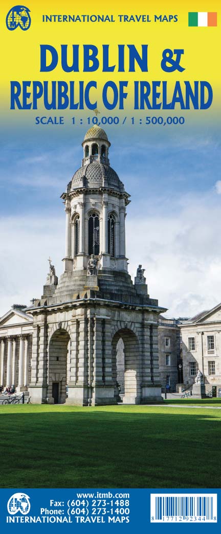
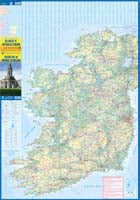
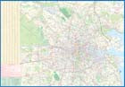
Dublin & Republic of Ireland
Ordinær pris 199,00 krWe are pleased to present our most recent edition of Dublin, combined with a map of Ireland on the reverse side. The cover notes the Republic of Ireland, which is the focus of attention, but most of Northern Ireland (Belfast area excluded) shows as well. Regardless, one side of the sheet is a detailed map of Dublin, the capital of the Republic and a very popular travel destination.
The coverage goes far beyond the norm, extending from the River Tolka in the north to south of the Grand Canal, and from Phoenix Park in the west as far east as the Dublin Bay. The River Liffey, of course, flows across the centre of the page. Dublin has two rapid-transit tram lines, both of which are prominently shown, as is the city centre, all parks, as many hotels as we could find, shopping areas and restaurants, theatres and educational institutions, embassies, the ferry terminal, and much more.
The Top Attractions are also noted. The other side of the sheet presents a very detailed travel map of the Republic, showing all motorways, highways, and secondary routes, as well as rail lines. Touristic attractions, such as Blarney Castle and the Rock of Cashel are highlighted. This would be an excellent map for those touring the Republic by road.
El Salvador & Guatemala South
Ordinær pris 149,00 krITM har kart over hele verden og de spesialiserer seg på land litt utenfor allfarvei. Beliggenheten til landets nasjonalparker, historiske monumenter, de viktigste veiene o.L. Finner du inkludert i kartene. Samtlige landkart har ofte et bykart over hovedstaden.
Fra ITM: 6th edition November 2018. This is a double-sided map with the El Salvador (1:270.000) on one side, along with a detailed inset map of San Salvador. The maps also shows the country's World Heritage city of Chalchuapa, dating back 3,200 years. The other side of the sheet is a completely separate maps of neighbouring Guatemala, being a detailed map of the central southern portion (1:457.000)of this important country. The highlights shown on this map are Quetzaltenango, Antigue Guatemala, and the Mayan ruins of Quirigua, dating from 200ad. The border crossings with El Salvador are clearly shown and are easily crossed.
Publisert år: 2018
Innbinding: falset
Material: vanntett papir
Målestokk: 1:250,000 / 1:457,000
Ethiopia & Eritrea
Ordinær pris 199,00 krITM har kart over hele verden og de spesialiserer seg på land litt utenfor allfarvei. Beliggenheten til landets nasjonalparker, historiske monumenter, de viktigste veiene o.L. Finner du inkludert i kartene. Samtlige landkart har ofte et bykart over hovedstaden.
Fra ITM: Double-sided map with Ethiopia at 1:1,900,000 accompanied by a street plan of Addis Ababa, with on the reverse Eritrea at 1:915,000 with a plan of Asmara. Both road maps are indexed and show the topography by altitude colouring: in Ethiopia with bands in metres and peak heights given in both metres and feet, and in Eritrea with bands in feet and peak heights either in feet and metres or in feet only.
Europe Eastern: Railway & Road
Ordinær pris 199,00 krEurope may be small in comparison to Canada, but it is densely populated and difficult to map as a continent while providing detail. Eastern Europe used to be defined as everything behind the Iron Curtain during the Cold War, but now it encompasses everything east of Germany and Switzerland, which means that this map covers Italy, Greece and the Balkan countries, the Central European countries of Romania and Hungary and most of Ukraine, Poland and the three Baltic states, and western Russia as far east as Volgograd, as well as much of Turkey. It is a combined road and rail map, showing motorways and major highways, fast-train routes in red and regular services in black. It also shows major cruise line routes, although many have been suspended due to Covid and political situations in Russia and Turkey.
Essentially, this is a map covering a very large area, as are our maps of Western and Central Europe, and our earlier map of Scandinavia. We have tried to make it politically correct, which is difficult considering the Russian occupation of Crimea and the Donetsk region of Ukraine and the on-going controversy over the ‘proper’ name for Macedonia, so we apologize for any errors. For simplicity’s sake, we have named most place names in English, so Roma is Rome and Moscva is Moscow etc. Fortunately, most English place names are the same in the local languages. However, being ITMB, Naples is Napoli, and Florence is Firenze, so don’t be too critical of us; we’re trying to reconcile differing perspectives.
France: French Atlantic Coast - Rail & Bike
Ordinær pris 179,00 krFrance is a rather large country, and while it can be portrayed on a map as a country, mapping it in segments provides an opportunity to concentrate on regions at a better scale. This map, covering the coastal region of France from the Cotenin Peninsula south to the Spanish border and east as far as Paris and Montpellier in Languedoc is the first of what we hope will be a series covering the country at an improved scale. This map is double-sided, covering from Quimper and Paris at the northernmost portion of coverage, to Angouleme and Clermont at the southern extreme on one side, with the second side covering from Bordeaux and St-Etienne south to Bayonne/Pamplona and Nimes/Avignon in the south. This is a part of Europe that has been fought over for centuries, and as such is dotted with fortresses proclaiming its historic importance.
This map has been designed with the leisure traveller in mind. Although it shows all motorways and highways, rail connections by train are emphasized, as are long-distance Euro-Velo cycling routes that are being developed in many parts of Europe. At this scale, it would be impractical to record all accommodations, but we have included a new feature that is thus far peculiar to France, and that is motorway hotels at rest areas. Naturally, the map is rich with places of touristic interest.
France: North Rail & Bike
Ordinær pris 199,00 krFrance: South Rail & Bike
Ordinær pris 199,00 krThis is a brand new title for ITMB and an attempt to portray a changing travel landscape in a mapping format. Eco-tourism is a rapidly growing activity, with enormous potential. At the same time, governments are seeking to reduce carbon pollution by encouraging train travel, so ITMB is climbing aboard the movement by publishing a map encouraging train travel while still retaining the road network and noting all the long-distance bike routes in southern France by designated number.
This is, by its scale, a generalized map of that portion of France south of Poitiers or Lyon to the Mediterranean, so is more of a regional map showing biking opportunities than a detailed trail map. Nevertheless, it is an excellent map on waterproof paper showing cycling routes and tertiary roads that are suitable for recreational exploration. Naturally, motorways and main highways are shown as well. Legend Includes: Roads by classification, Rivers and Lakes, National Park, Airports, Points of Interests, Mining, Highways, Main Roads, Zoos, Fishing, , and much more...
Geneva & Western Switzerland
Ordinær pris 199,00 krITM har kart over hele verden og de spesialiserer seg på land litt utenfor allfarvei. Beliggenheten til landets nasjonalparker, historiske monumenter, de viktigste veiene o.L. Finner du inkludert i kartene. Samtlige landkart har ofte et bykart over hovedstaden.
Fra ITM: Geneva is an ancient Swiss town close to the French border, nestled along the edge of Lake Leman, and is bisected by the Rhone River. The old town is on the left, or lower, bank and is loaded with shops and restaurants. The ‘new’ town is on the right, or upper, bank and contains the downtown shopping area and the main railway station. The United Nations complex, the Palais des Nations, is a bit of a walk to reach, so fortunately there is a tram that goes right to the gates. The airport is shown at the top of the page. The 2nd side is a new map for us, covering the western half of Switzerland as far as Basle and Luzern, concentrating on the rail network as well as the roads. For example, it shows the rail line to Zermatt, at the base of the Matterhorn.
Publisert år: 2025
Innbinding: falset
Material: papir
Målestokk: 1:6,700 / 1:301,000
Great Britain
Ordinær pris 199,00 krITM har kart over hele verden og de spesialiserer seg på land litt utenfor allfarvei. Beliggenheten til landets nasjonalparker, historiske monumenter, de viktigste veiene o.L. Finner du inkludert i kartene. Samtlige landkart har ofte et bykart over hovedstaden.
Fra ITM: This is the third set of artwork for Great Britain that we have published and the first that is completely our own artwork (the previous versions were joint ventures). In mapping, as in life, one has to differentiate between the political entity known as the United Kingdom and the geo-political reality of Greater Britain, which includes the Channel Islands, the Isle of Man, and various assorted entities that are loosely attached to the UK by history. We have tried, in this edition, to combine a detailed road map with a touristic sites map. Given that Britain is both densely covered by thousands of narrow laneway passing themselves off as sub-B level roads and by having the greatest treasure trove in the world of castles, manor houses, gardens, museums, and interesting places worth visiting, and the task of portraying all this information becomes formidable. To keep the map from becoming too cluttered, we had to compromise, so if you don’t find the little laneway leading to your favourite pub in Devon, sorry. We've done our best to portray Britain as positively as possible, so if you're hankering to visit Foula Island, it's on the map!
Publisert år: 2025
Innbinding: falset
Material: plastpapir
Målestokk: 1:720,000
Great Britain: England - Southeast & Midlands Railway & Road
Ordinær pris 199,00 krThe shape of the UK makes it difficult to map logically. The term South East, within crowded England, is generally more restrictive than is appropriate for a map. Our definition of SE is from the English Channel north to the northern tip of East Anglia and west to Portsmouth/Reading/Peterborough. This occupies side one of the sheet. Side two consists of that complex portion of England generally called ‘The Midlands’ stretching from Cambridge/Peterborough west to the Welsh border and from Luton/Gloucester north to Manchester/Grimsby. London is, of course, prominent, but only as a main roads map.
This is the most recent sectional map of the UK that ITMB has published, and was necessitated by the realization that, to see England properly, one needs a detailed enough map to show rail lines, motorways, A-type highways and B-type secondary roads, but also the tertiary level of road joining villages. The road network of England is incredibly complex and cannot be shown in proper detail without mapping at this scale or better. England also has a sophisticated rail network and this is left off most maps to avoid clutter. We have emphasized all the rail lines carrying passengers, which makes the London portion look like a spaghetti factory, but there are lines everywhere. All motorways and highways are shown, but rail lines are prominently shown, to encourage travel by train. A Top Attractions list has been included as well, but hundreds of interesting touristic sites have been included.
Great Britain: England East Coast
Ordinær pris 199,00 krThe United Kingdom may be geographically small, but it is so packed with touristic sites that it needs to be broken down into logical units to be manageable. This is the first of several maps we will be publishing of England at 1:250,000 scale, covering Southeast England from Dover to Southampton north to Luton on Side 1 and from Colchester to Coventry north to Sheffield and Boston; essentially all of SE England from the Channel to Derbyshire and west to the Isle of Wight.
Even at this scale, there is only room to show major attractions without creating clutter. Both road and rail routes are clearly shown, with rapid-rail routes shown in red. This latter feature is not included on most other maps, an one notes with a bit of surprise that this part of England has more such routes than is generally believed to exist. We travelled on one of these trains during our recent visit to the UK (albeit from Newcastle to Edinburgh) and they are quite an improvement! Whether by train or by road, all options are shown. Whether one wishes to visit Hever Castle in Kent or Winchester cathedral, or the university cities of Cambridge or Oxford, this is an ideal map for exploring one of the most touristic corners of Europe.
Greece: Crete; Mykonos & Santorini
Ordinær pris 169,00 krThe many islands off the coast of Greece can only be mapped properly a few at a time. Side 1 of this map shows the large island of Crete in good detail, with the relatively nearby island of Mykonos and its adjacent island of Rinia and the island of Santorini, with its adjacent islands of Thirasia and Nea Kameni being shown in great detail. A locality map showing the islands in relation to the rest of Greece is included as an inset. It is our intention to map more islands as time passes, but this depends upon future research trips (we lead a hard life!).
Side 2 of the map is a general map of Greece in relation to its neighbours to the north and east. The Mediterranean is divided into smaller seas, such as the Adriatic along the coast of Croatia, the Ionian to the west of Greece, the Myrtoan to its south and the Aegean to its east. All this area is replete with islands and geopolitical conflicts. As such, this map is useful for showing the region as an entity that links the Balkan states to the eastern Mediterranean.
Guam & West Pacific Cruising
Ordinær pris 169,00 krWe are very pleased to be (finally) able to publish the first travel map of the island of Guam. Certainly, this is the only map of Guam by any major cartographic publishing house. Here are some details: Guam is a north-south island considerably north of New Guinea, and forms part of the American-held group of islands known as the Northern Marianas. Its capital is Hagatna, and the main town is called Tamuning. The island has a well-developed international airport in the middle portion of the island, with a large US military airbase in the northeast corner. The vast majority of the island is touristic, and well worth a visit. The island was "discovered" by Ferdinand Magellan in 1521, and Hagatna is the oldest "European" city in the Pacific, dating from 1686. The town of Inarajan retains a decidedly Spanish appearance to this day. Other attractions include Tumon Beach and its many resorts, the Piti Underwater Observatory, and the famous Cocos Island dive wall.
This is a double-sided map, with the Western Pacific Cruising map gracing the second side of the page. This side covers several island entities, and stretches from Australia in the south to Japan in the north and as far to the east as Hawaii and the Cook Islands, so includes such popular cruise destinations as Fiji, Tonga, New Caledonia, the Solomons, Papua, Samoa, Kiribati, and the Marshall Islands. It makes a lovely wall map!
India: Mumbai & West Coast
Ordinær pris 179,00 krMumbai, formerly Bombay, is the largest city on India's west coast. Tradditionally known as the Gateway to India, it is a huge, bustling metropolis. Our map covers the city centre and lower portion of the peninsula, with a detailed inset map showing the overall urban area. The map also includes the city's Top Attractions. Mumbai is also one of the major entry points for flights into India, which is why we have re-worked the map into a double-sided product with the west coast of India, from the far south to north of Surat. This essentially covers southern India and provides an excellent supplement for those visiting India starting with Mumbai. The popular enclaves of Goa, Damien, and Pondicherry are also included, as is the crossing to Sri Lanka.
Indonesia: Sumatra
Ordinær pris 199,00 krITM har kart over hele verden og de spesialiserer seg på land litt utenfor allfarvei. Beliggenheten til landets nasjonalparker, historiske monumenter, de viktigste veiene o.L. Finner du inkludert i kartene. Samtlige landkart har ofte et bykart over hovedstaden.
Fra ITM: The Indonesian island of Sumatra is not only the largest portion of this nation of islands, it is also very close to Singapore and Malaysia, so has easy connections to both countries as well as to other parts of Indonesia. Side 1 shows the northern portion of Sumatra, with an excellent inset map of Medan, its major city. Several offshore islands are included, as well as a significant Top Attractions list. Side 2 shows the bulk of the island as well as a portion of southern Malaysia, Singapore, and various islands in the vicinity. Ferry routes to Java, Malacca (part of Malaysia), the Lingga and Riau Archipelagoes and Singapore are included, as well as inset maps of Padang and Palembang, the two major cities in the south. Sumatra has a well-developed road network along its western side, but not along its eastern portion, except in the far north. Thus, the island remains a place for adventure travel waiting to be discovered.
Publisert år: 2024
Innbinding: falset
Material: papir
Målestokk: 1:1100.000
Iraq & Baghdad
Ordinær pris 199,00 krITM har kart over hele verden og de spesialiserer seg på land litt utenfor allfarvei. Beliggenheten til landets nasjonalparker, historiske monumenter, de viktigste veiene o.L. Finner du inkludert i kartene. Samtlige landkart har ofte et bykart over hovedstaden.
Fra ITM: Iraq is one of those countries that should be on everyone’s bucket list to visit at least once. It has had an extremely unpleasant modern history, from which it is recovering, and finding a degree of stability that is encouraging. The north of the country, which is in Kurdish hands, is the most stable, and hence, most touristic part of the country. The south is divided between Sunni and Shite religious factions and, although interesting to visit, is a tad less stable. The most interesting part of this map is the detailed street map of Baghdad on Side 2. This is the only known paper map of the city and became famous during the siege of Baghdad in 2003 as it was the ONLY map available to the Allied forces approaching the city. Nine million copies were printed by National Geographic Society for their excellent article on the city and was used by countless soldiers trying to find their way safely around a very complex urban area. Fortunately, it is reasonably safe to visit it now. Definitely a country for adventure tourism!
Publisert: 2025
Innbinding: falset
Material: papir
Målestokk: 1:1,200,000 / 1:22,000
Italy: Sicily; Sardinia & The South
Ordinær pris 169,00 krITM har kart over hele verden og de spesialiserer seg på land litt utenfor allfarvei. Beliggenheten til landets nasjonalparker, historiske monumenter, de viktigste veiene og lignende finner du inkludert i kartene. Samtlige landkart har ofte et bykart over hovedstaden.
Jamaica & Cayman Islands
Ordinær pris 149,00 krITM har kart over hele verden og de spesialiserer seg på land litt utenfor allfarvei. Beliggenheten til landets nasjonalparker, historiske monumenter, de viktigste veiene o.L. Finner du inkludert i kartene. Samtlige landkart har ofte et bykart over hovedstaden.
Fra ITM: This map was called Cayman Islands and Jamaica in its previous edition, which was a well-intentioned attempt to promote the smaller islands adjacent to big brother. Now, we are reverting to what we think is a more logical title arrangement for listing purposes, but the map has two covers, so one can market it as either Jamaica or the Caymans, or best of all, market both! We visited the Caymans a few months ago and drove every road on the main island, including a few that turned out to be driveways! The map is very current as a result. The other side of the map is the very popular touristic island of Jamaica, now into its sixth edition. This island is large enough to justify renting a car and exploring. It is a great way to discover hidden coves and find historic plantations, especially along the touristic north shore. 6th/3rd Ed. 1:250,000/1:37,500
Publisert år: 2017
Innbinding: falset
Material: papir
Målestokk: 1:250000/37,500