Filter
- Algerie
- Angola
- Australia
- Benin
- Bhutan
- Bolivia
- Botswana
- Burkina Faso
- Burundi
- Canada
- Djibouti
- Ecuador
- Egypt
- Ekvatorial-Guinea
- Elfenbenskysten
- Eritrea
- Eswatini
- Etiopia
- Frankrike
- Gabon
- Gambia
- Ghana
- Guinea
- Guinea-Bissau
- India
- Irland
- Italia
- Japan
- Jordan
- Kamerun
- Kapp Verde
- Kenya
- Kina
- Komorene
- Kongo
- Lesotho
- Liberia
- Libya
- Madagaskar
- Malawi
- Maldivene
- Mali
- Marokko
- Mauritania
- Mauritius
- Mexico
- Mosambik
- Namibia
- Nepal
- New Zealand
- Niger
- Nigeria
- Norge
- Oman
- Polen
- Rwanda
- Senegal
- Seychellene
- Sierra Leone
- Singapore
- Somalia
- Spania
- Sri Lanka
- Sudan
- Sveits
- Sør-Afrika
- Sør-Korea
- Sør-Sudan
- Tanzania
- Togo
- Tunisia
- Tyrkia
- Tyskland
- Uganda
- Zambia
- Zimbabwe
- Østerrike
211 produkter
211 produkter
Utsolgt
Africa: Chad
ITM
199,00 kr
Utsolgt
Rwanda
Culture Smart
179,00 kr

139 Zoom - la Reunion
Ordinær pris 169,00 kr/
Mva inkludert
Frakt beregnes i kassen.
Michelin er en av verdens beste, og best kjente, kartserier. Kartene har glimrende kartografi.
Inset maps of Saint-Denis, St-Pierre, St-Gilles and Gilaos. MICHELIN Zoom map highlights all the leisure activities available; such as golf clubs and tourist trains. MICHELIN Zoom Maps also include star-rated scenic routes; tourist sights & attractions; as well as camping sites and hotels selected in the famous MICHELIN guides. Make the most of your stay with MICHELIN Zoom Maps!
Publisert år: 2017
Innbinding: falset
Material: Papir
Målestokk: 1:80000

745 Africa: North East & Arabia
Ordinær pris 169,00 kr/
Mva inkludert
Frakt beregnes i kassen.
Michelin er en av verdens beste, og best kjente, kartserier. Kartene har glimrende kartografi. Rød serie, kalt “national”. Dekker et enkelt land eller en gruppe land primært med hovedferdselsårer.
Publisert år: 2019
Innbinding: falset
Material: papir
Målestokk: 1:4000000

744 Africa: Tunisia
Ordinær pris 169,00 kr/
Mva inkludert
Frakt beregnes i kassen.
Michelin er en av verdens beste, og best kjente, kartserier. Kartene har glimrende kartografi. Rød serie, kalt “national”. Dekker et enkelt land eller en gruppe land primært med hovedferdselsårer.
Publisert år: 2020
Innbinding: falset
Material: papir
Målestokk: 1:800000

Ethiopia & Eritrea
Ordinær pris 199,00 kr/
Mva inkludert
Frakt beregnes i kassen.
ITM har kart over hele verden og de spesialiserer seg på land litt utenfor allfarvei. Beliggenheten til landets nasjonalparker, historiske monumenter, de viktigste veiene o.L. Finner du inkludert i kartene. Samtlige landkart har ofte et bykart over hovedstaden.
Fra ITM: Double-sided map with Ethiopia at 1:1,900,000 accompanied by a street plan of Addis Ababa, with on the reverse Eritrea at 1:915,000 with a plan of Asmara. Both road maps are indexed and show the topography by altitude colouring: in Ethiopia with bands in metres and peak heights given in both metres and feet, and in Eritrea with bands in feet and peak heights either in feet and metres or in feet only.
- Publisert: 2020
- Innbinding: Falset
- Materiale: Papir
- Målestokk: 1:900,000 / 1:915,000

Togo & Benin
Ordinær pris 169,00 kr/
Mva inkludert
Frakt beregnes i kassen.
ITM har kart over hele verden og de spesialiserer seg på land litt utenfor allfarvei. Beliggenheten til landets nasjonalparker, historiske monumenter, de viktigste veiene og lignende finner du inkludert i kartene. Samtlige landkart har ofte et bykart over hovedstaden.
Fra ITM: The two small countries squeezed between Ghana on the west and Nigeria on the east developed out of the European colonialization of most of Africa Germany, under Kaiser Bill, was determined to create an empire to rival that of Britain, and seized a portion of the coastline close to the British-held area of Ghana and held on to it until WW1 ended Germany’s colonial aspirations. Britain and France jointly governed Togo briefly, but the territory was ceded to France until independence was granted in the 1960s. Neighbouring Benin (formerly the French colony of Dahomey) was all that the French colonial office could obtain of the rich coastal plain until the German defeat in WW1, which gained it Togo and German Cameroun, further to the east. Both countries have their points of interest, but to this day have little to do with each other. There is one border crossing on the coast, and a couple of others much farther inland, but each country operates on a north-south basis, not an east-west one. The map includes inset maps of Lome, the capital of Togo, and Porto Novo, in Benin, which is now the capital. Togo’s best sites are noted in a red inset box, with a separate box for Benin.
- Publisert: 2019
- Innbinding: Falset
- Materiale: Papir
- Målestokk: 1:530 000

Somalia & Horn of Africa
Ordinær pris 169,00 kr/
Mva inkludert
Frakt beregnes i kassen.
ITM har kart over hele verden og de spesialiserer seg på land litt utenfor allfarvei. Beliggenheten til landets nasjonalparker, historiske monumenter, de viktigste veiene og lignende finner du inkludert i kartene. Samtlige landkart har ofte et bykart over hovedstaden.
Fra ITM: 3rd Edition Somalia is one of the more itneresting off-the-beaten-path countries. The area around Mogadishu prefers to call itself Somalia, but controls only a portion of the overall country area. Then there is Jubaland, on the Kenyan border, aligned very closely to the former Italian colony boundaries of the same name. Truuly, an amazing juxtaposition of countries within countries! the reverse side of the sheet presents a vey interesting regional perspective of the area between the northern border of Ethiopia, a small portion of Sudan and a reasonable portion of South Sudan, all of Uganda, most of Kenya, all of Djibouti and a fair portion of Eritrea, as well as the former Aden portion of war-torn Yemen. The strategic island of Socotra is in the upper right corner. This is a fascinating regional map, never before published to my knowledge, of an extremely significant part of the world. Think of the following: Socotra guards and controls access to the Gulf of Aden and the Red Sea, leading to the Suez Canal. What an interesting part of the world! How can anyone not be captivated by such wonderfully exotic names as Hargeysa, Boosaaso, or Kismayyo? Somalia and the region of the Horn remain crucially important to world peace, so this map is important.
Publisert år: 2020
Innbinding: falset
Material: plastpapir
Målestokk: 1:1,700,000 / 1:2,400,000

Lesotho
Ordinær pris 179,00 kr/
Mva inkludert
Frakt beregnes i kassen.
Infomap™ er kongen av road-trip kart i den sørlige delen av afrika. Godt detaljerte og oppdaterte veikart i papir. Kartene inneholder også skogs - og landeveier for deg som vil utenfor allfarvei. Perfekt kompanjong på safari eller andre eventyr. Har gps-koordinater.
Publisert år: 2018
Innbinding: falset
Material: papir
Målestokk: 1:400000

Mount Elgon - Map and Guide
Ordinær pris 149,00 kr Salgspris 119,00 kr Spar 20%/
Mva inkludert
Frakt beregnes i kassen.
Kart over Mount Elgon. Kartet ble publisert i 1989, men er fortsatt det mest oppdaterte på området i 2025.
- Publisert: 1989
- Innbinding: Falset
- Materiale: Papir
- Målestokk: 1:500 000


Burkina Faso & Niger
Ordinær pris 149,00 kr/
Mva inkludert
Frakt beregnes i kassen.
ITM har kart over hele verden og de spesialiserer seg på land litt utenfor allfarvei. Beliggenheten til landets nasjonalparker, historiske monumenter, de viktigste veiene o.L. Finner du inkludert i kartene. Samtlige landkart har ofte et bykart over hovedstaden.
Fra ITM: Burkina Faso and Niger on a double-sided, indexed map from ITMB, presenting each country separately at 1:1,000,000 1:1,950,000 respectively and accompanied by street plans of Ouagadougou, Bobo-Dioulasso and Niamey. Altitude colouring shows the topography (with bands in feet in Burkina Faso and in metres in Niger). In Burkina Faso the map indicates areas of periodic inundation, whilst in Niger numerous water wells, salt pans, sand dunes and lava fields are also marked. In both countries parks and nature reserves are highlighted.
Road network indicates seasonal roads and shows locations of fuel supplies and border crossings, plus distances on main routes. Airports and aerodromes for small craft are marked; towns are annotated with symbols indicating what facilities can be found there. Each map has latitude and longitude lines (at 1° in Burkina Faso and 2° in Niger), plus a separate index.
Street plans, annotated with names of hotels, various tourist facilities and main buildings cover Ouagadougou (with an enlargement for the town cente), Bobo-Dioulasso and Niamey.
Publisert år: 2013
Innbinding: falset
Material: papir
Målestokk: 1:1950000

Uganda Animal Kingdom
Ordinær pris 259,00 kr/
Mva inkludert
Frakt beregnes i kassen.
Uganda Animal Kingdom. African might. There are a number of reasons why people are choosing to take Tour and holidays in Uganda out of all the 54 countries on the African continent. After many years of bad publicity from wars and disease, things turned around for Uganda, especially in 2006, when Kony and his Lord's Resistance Army were run out of the country. Some of the things that have caused this surge in popularity and made Uganda make it to the list of the top 20 travel destinations include; Primates such as Gorillas: It came to the attention of both Uganda and the rest of the world that Uganda is primate country. From monkeys, to baboons to chimpanzees and to the rare and sought after golden monkeys and mountain gorillas.
There is no better country to visit if you are looking to see primates of different kinds. In the past five years gorilla trekking in Uganda has become one of the most sought after Africa safari adventures. The pearl of Africa is home to more than half of the world's population of mountain gorillas, and some of these have been habituated so visitors can get to see them in their natural habitat. Chimpanzees too are an attraction in Uganda, they are found in various places in the western part of Uganda. The golden monkeys, also quite a rare species are found in Mgahinga national park on the foothills of the Virunga Mountains. It is because of the abundance of primates that Bwindi Impenetrable Forest, Mgahinga national park, and other parks in the western part of the country have a lot of tourist traffic.
- Forfatter: Christopher Walsh
- Publisert: Juli 2022
- Utgave: 1. utgave
- Antall sider: 158
- Innbinding: Heftet
- Språk: Engelsk
- ISBN: 9781715305314

Soul of: Marrakesh
Ordinær pris 209,00 kr/
Mva inkludert
Frakt beregnes i kassen.
Soul of Marrakesh guide is a new approach to the art of travelling that consists of vagabonding around, chance encounters, and unforgettable experiences. Yves St Laurent’s private library, the best orange juice in the legendary Jamaa el-Fna square, the most beautiful riads and the best restaurants far from the tourist crowds, the search of the perfect carpet, a night in a tent in the desert, a secret museum where everything is for sale …?Soul of Marrakesh guide will unlock the hidden doors of this fascinating city, capture its essence and delve into every last nook and cranny to uncover its soul. Don’t miss - Hidden inside these guides, you will always find a very secret location, carefully selected, waiting to be discovered.
- Publisert: Oktober 2022
- Antall sider: 128
- Språk: Engelsk
- Innbinding: Heftet
- ISBN: 9782361954659


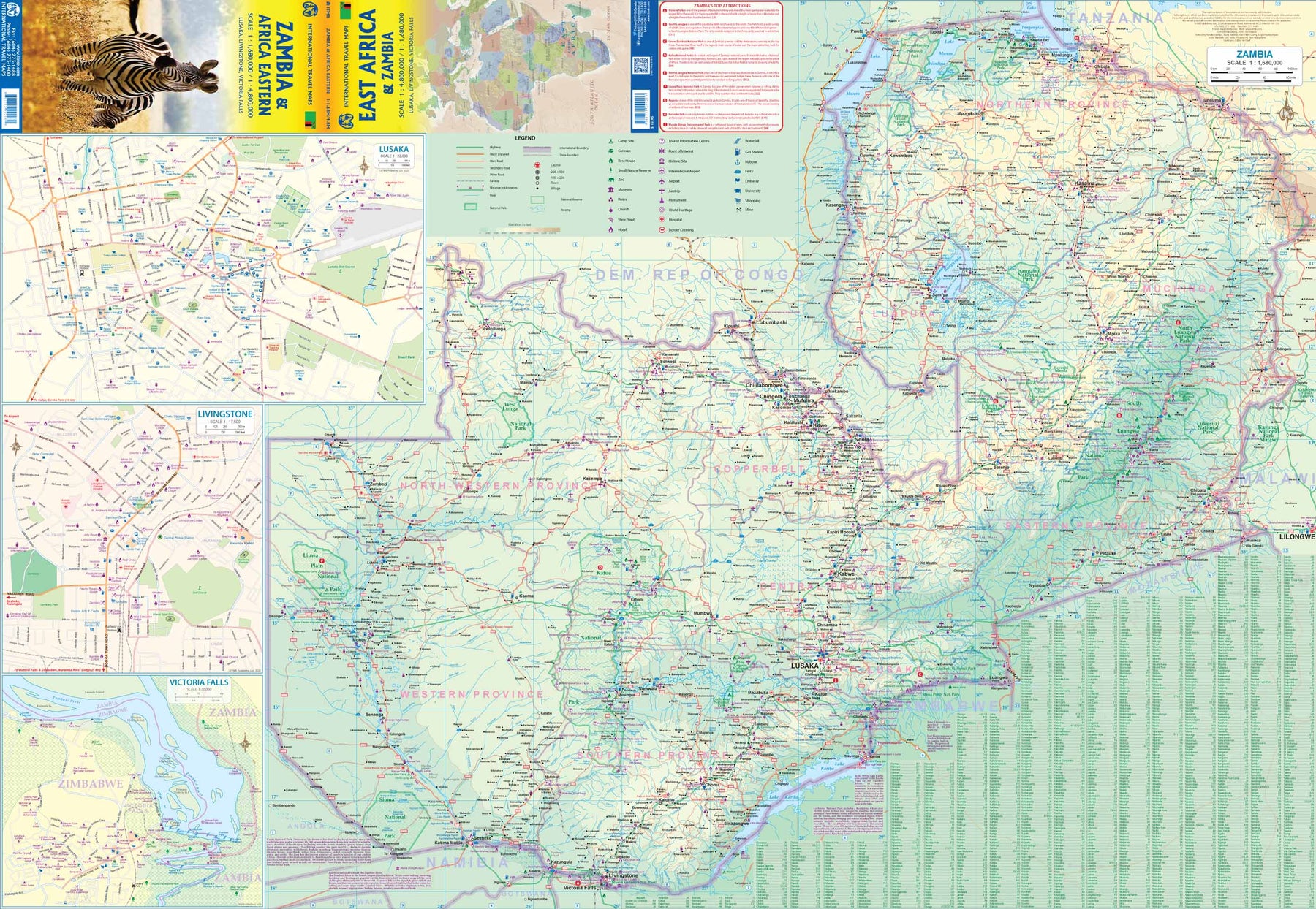
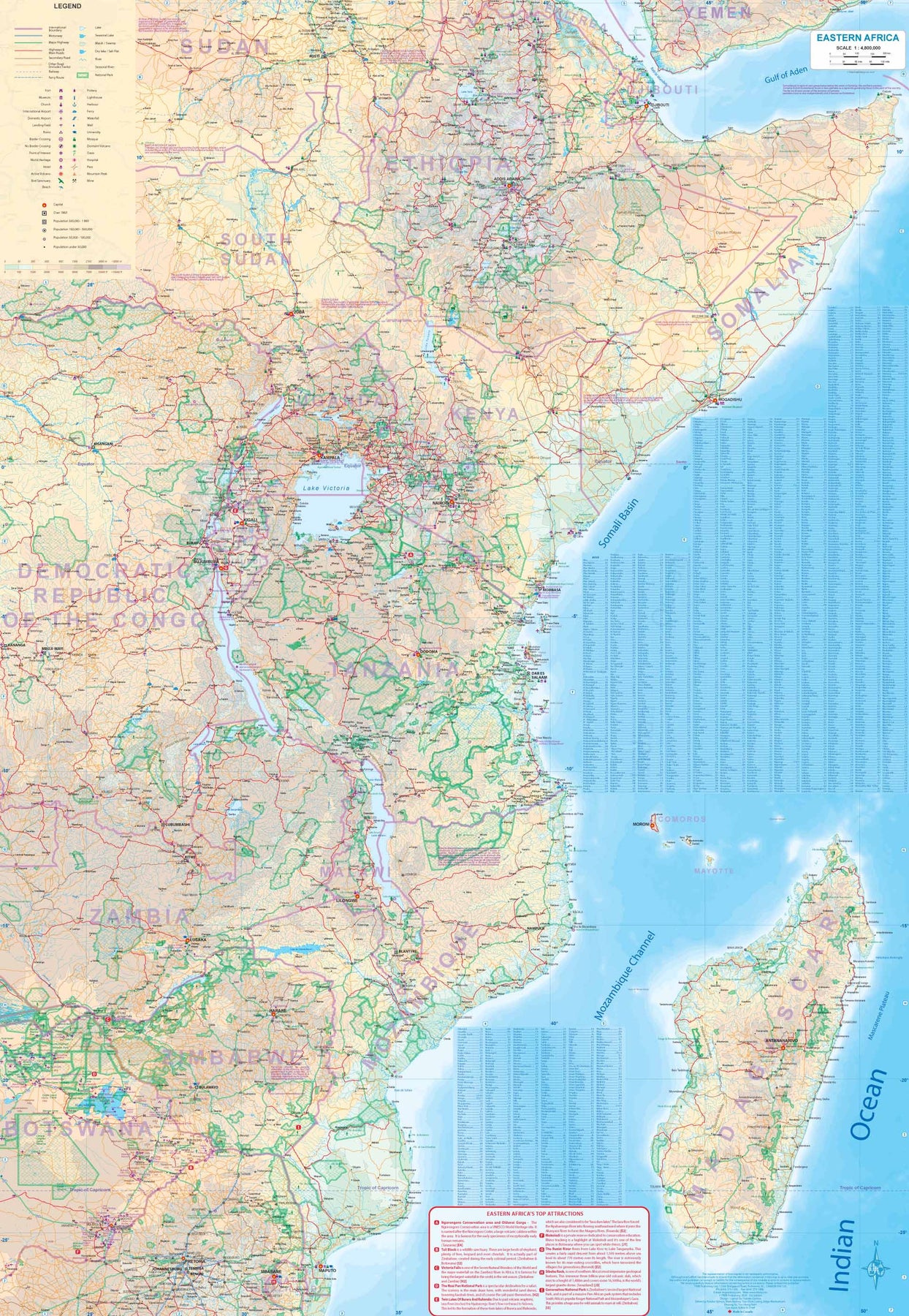
Africa: Zambia & Eastern
Ordinær pris 179,00 kr/
Mva inkludert
Frakt beregnes i kassen.
Zambia, a nice country in central/southern Africa graces one side of the sheet, along with a very large inset map of Lusaka and two others of Livingstone and Victoria Falls (which is actually in Zimbabwe). The other side of the sheet contains a very useful regional map of eastern Africa from Ethiopia/Eritrea south to Eswatini/Swaziland. Madagascar is also included, as well as the Comoro Islands. While both sides are useful, it is the Zambian side that takes precedence. All the roads and towns are shown, as well as parks, safari lodges, and points of interest. It is possible, though not advisable, to travel to Zimbabwe via either Kariba or Vic Falls, and there is a good crossing into Botswana at Sesheke. Entry to and from Tanzania and Malawi is easy.
- Publisert: 2020
- Innbinding: Falset
- Materiale: Plastpapir
- Målestokk: 1:1 680 000, 1:4 800 000