Filter
- Afghanistan
- Armenia
- Aserbajdsjan
- Australia
- Bangladesh
- Bhutan
- Bolivia
- Brunei
- Canada
- Ecuador
- Filippinene
- Frankrike
- Georgia
- India
- Indonesia
- Irak
- Iran
- Irland
- Israel
- Italia
- Japan
- Jordan
- Kambodsja
- Kasakhstan
- Kina
- Kirgisistan
- Kuwait
- Laos
- Libanon
- Malaysia
- Mexico
- Mongolia
- Nepal
- New Zealand
- Nord-Korea
- Norge
- Oman
- Pakistan
- Palestina
- Polen
- Russland
- Serbia
- Singapore
- Spania
- Sri Lanka
- Sveits
- Sør-Korea
- Taiwan
- Thailand
- Turkmenistan
- Tyrkia
- Tyskland
- Usbekistan
- Vietnam
- Zambia
- Zimbabwe
- Øst-Timor
- Østerrike
202 produkter
202 produkter

Everest & Gokyo
Ordinær pris 299,00 kr Salgspris 149,50 kr Spar 50%/
Mva inkludert
Frakt beregnes i kassen.
A detailed 1:60,000 scale map showing the area around the Everest Region and Gokyo, including the Cho La and Renjo passes.
Showing routes from Lulka to Everest Base Camp, Thame, the Renjo Pass, Pheriche and Gokyo. It has a grid lines with reference numbers and a detailed English key sheet.
Time taken and height gained from place to place are also shown on a table on the cover. Two 1:4000 scale maps are included, one of Namche Bazar and one of Lukla, showing roads and local amenities.
- Publisert: 2016
- Innbinding: Falset
- Materiale: Papir
- Målestokk: 1:60 000

Southeast Asia
Ordinær pris 299,00 kr/
Mva inkludert
Frakt beregnes i kassen.
This Southeast Asia guidebook is ideal for travellers seeking inspirational guides and planning a more extended trip. It provides interesting facts about Southeast Asia's people, history and culture and detailed coverage of the best places to see. This Southeast Asia travel book has the style of an illustrated magazine to inspire you and give a taste of Southeast Asia.
- Publisert: April 2024
- Antall sider: 464
- Innbinding: Heftet
- Språk: Engelsk
- ISBN: 9781839053856

Lonely Planet Best Bike Rides: Japan
Ordinær pris 259,00 kr/
Mva inkludert
Frakt beregnes i kassen.
Lonely Planet's Best Bike Rides Japan reveals 35 incredible two-wheeled escapes–with maps–so you can experience even more of this extraordinary country. Get ready for an unforgettable bike ride across Japan and discover exhilarating cycling adventures that range from a couple of hours to a full day. Travel through Nichinan-Kaigan Quasi-National Park for dramatic cliffs and ocean spray; spot Pokémon manhole covers as you glide along the Ibusuki Poké Trail; and find art museums and exclusive galleries in the mountain town of Karuizawa.
- Publisert: Okt. 2025
- Utgave: 1. utgave
- Antall sider: 240
- Innbinding: Heftet
- Språk: Engelsk
- ISBN: 9781838698157

Three Passes - Everest/Gokyo
Ordinær pris 299,00 kr/
Mva inkludert
Frakt beregnes i kassen.
1:50,000 scale map printed on waterproof, durable material. This beautiful, folded map, is the perfect reference map, guidebook, and planner aid to anyone attempting this long, difficult trekking adventure.
Features three passes;
Kongma La
Chola Pass
Renjola Pass
- Publisert: 2018
- Innbinding: Falset
- Materiale: Papir
- Målestokk: 1:50 000

Saudi Arabia
Ordinær pris 109,50 kr/
Mva inkludert
Frakt beregnes i kassen.
From a distance, Saudi Arabia may seem a subdued, or even dull place; but for those who take a closer look it emerges as a fascinating country, not necessarily because of its political and economic importance, but because of its people. Reticent perhaps but, on closer acquaintance, charming and warm, the Saudis form a far less monolithic society than one might expect. Divided by region, creed, and background but united in Islam, insular yet forever traveling abroad, and living with a foreign contingent that makes up nearly one-third of the population: the list goes on.
So what do Saudis have in common beyond their national dress? Culture Smart! Saudi Arabia will help you navigate the swirling waters of this important and fast-changing country. Social, cultural, and business life is demystified in concise chapters, while sections on the values, traditions, and attitudes that prevail will help you find your way through the new and unexpected situations that you are likely to encounter.
- Publisert: Juni 2024
- Antall sider: 200
- Innbinding: Heftet
- Språk: Engelsk
- ISBN: 9781787023543


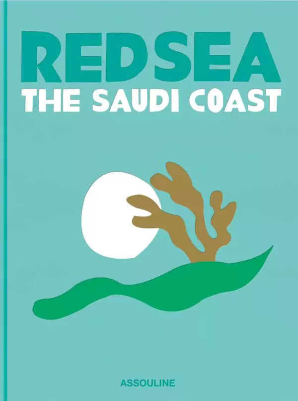
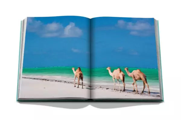
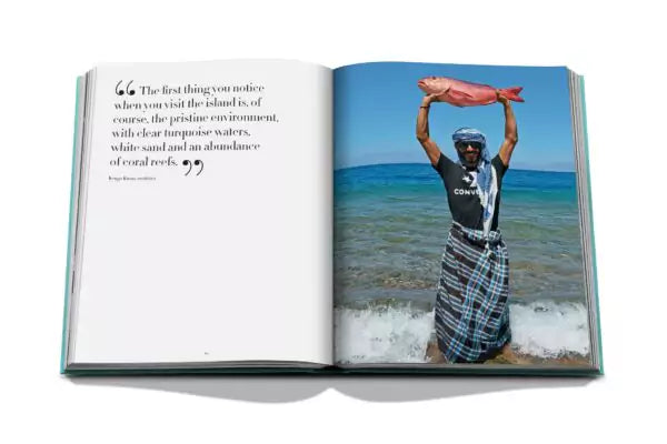


Red Sea: The Saudi Coast
Ordinær pris 1.499,00 kr/
Mva inkludert
Frakt beregnes i kassen.
Bordering the coastlines of eight countries, the Red Sea is a melting pot of civilizations, faiths and hopes. With unique coral reefs and diverse underwater life, the untouched nature and unmatched biodiversity thrive in the aquatic environment and have led to the creation of several preservation initiatives. As the setting of many epic journeys in literature, the Red Sea is imbued with a spirit of adventure. Photography by Aline Coquelle, Ameen Qaisaran and Afnan Alkhayat, Mohammed Al Sharif, and Yarob Bashrahil.
From serene desert expanses to coastal regions teeming with flora and fauna, the many wonders of Saudi Arabia are explored in our latest collection. This six-book series features original works by premier photographers and artists. Each volume uncovers a unique treasure of the Kingdom, whether an ancient city or historic tribe.
- Vekt 2,45 kg
- Mål 25 × 3,6 × 33 cm
- Innbundet
- 248 sider
- Språk: Engelsk

Gobi 5 - Baghdad
Ordinær pris 99,50 kr/
Mva inkludert
Frakt beregnes i kassen.
«Baghdad» avslutter beretningen om Wolfgang fra Godesberg. I denne romanen opptrer han som Den stumme, som omgir seg med en liten gruppe gatebarn. Året er 1258 og Baghdad er omringet av mongolene. Fortelleren er denne gangen Rodrigo som etter hvert knytt er seg til den stumme tiggeren og barneflokken som omgir ham. Mens byens innbyggere venter på mongolenes angrep, forteller Rodrigo om sitt liv.
- Forfatter: Tor Åge Bringsværd
- Publisert: 2018
- Innbinding: Heftet
- Språk: Norsk bokmål
- Antall sider: 191
- ISBN: 9788202561260

Gobi 3 - Djevelens skinn og ben
Ordinær pris 99,50 kr/
Mva inkludert
Frakt beregnes i kassen.
Djevelens skinn og ben er tredje bok i Tor Åge Bringsværds mektige epos fra middelalderen. Munken Eusebius er falt i unåde hos sin unge venn, den mektige Chu, rådgiver hos mongolenes khan. For å redde livet må han fortelle en historie på et unikt og mesterlig vis. Mens karavanen beveger seg gjennom Gobiørkenen mot Karakorum, fortelles en bestialitetens historie av et menneske på desperat flukt fra sine onde gjerninger og et uhyggelig Europa. Det er de store mennekselig sprøsmål forfatteren tumler med: meningen med livet, kjærlighetens mysterium, ondskapens problem.
- Forfatter: Tor Åge Bringsværd
- Publisert: 2018
- Innbinding: Heftet
- Språk: Norsk bokmål
- Antall sider: 375
- ISBN: 9788202561246

Gobi 2 - Djengis Khan
Ordinær pris 99,50 kr/
Mva inkludert
Frakt beregnes i kassen.
Under den legendariske Djengis Khan skapte mongolene det største imperium verden noen gang har sett. Et rike som strakte seg fra Stillehavet og langt inn i Europa.
Dette er beretningen om Djengis Khans vei til makten. For dem som fulgte ham, var han en bogdo – En Himmelens utvalgte. For alle andre var han Pesten, Døden og Djevelen selv.
Men samtidig er det også beretningen om Wolfgang fra Godesberg – den underlige gjøgleren som vi første gang møtte i Barndommens måne. Enda en gang betror han seg til tusj og silke. Han vil forsøke å beskrive Djengis Khan. Ikke som et monster. Men som et menneske.
- Forfatter: Tor Åge Bringsværd
- Publisert: 2018
- Innbinding: Heftet
- Språk: Norsk Bokmål
- Antall sider: 363
- ISBN: 9788202561239

Lonely Planet Burmese Phrasebook & Dictionary
Ordinær pris 64,50 kr/
Mva inkludert
Frakt beregnes i kassen.
Lonely Planet Burmese Phrasebook & Dictionary is your passport to the most relevant Burmese phrases and vocabulary for all your travel needs. Find out-of-the-way temples, learn the etiquette of visiting someone's home and bargain for fruit at a market -all with your trusted travel companion. With language tools in your back pocket, you can truly get to the heart of wherever you go, so begin your journey now!
- Publisert: Juli 2023
- Utgave: 6. utgave
- Antall sider: 222
- Innbinding: Heftet
- ISBN: 9781786570925

Lonely Planet Hill Tribes Phrasebook & Dictionary
Ordinær pris 129,00 kr Salgspris 64,50 kr Spar 50%/
Mva inkludert
Frakt beregnes i kassen.
Leave no Hill Tribe subgroup or culture unimpressed by a dash of your multi-lingual bon mots. Whether you're trekking Vietnam, China, Laos, Thailand or beyond, let this handy phrasebook do some talking. Covers Lahu, Akha, Lisu, Mong, Mien and more Individual guides to pronunciation, sounds and grammar Detailed language maps Practicalities - how to ask for directions or find a doctor Lonely Planet gets you to the heart of a place.
Our job is to make amazing travel experiences happen. We visit the places we write about each and every edition. We never take freebies for positive coverage, so you can always rely on us to tell it like it is.
- Publisert: Sept. 2025
- Utgave: 5. utgave
- Antall sider: 176
- Innbinding: Heftet
- ISBN: 9781788688321

Himalaya
Ordinær pris 199,00 kr Salgspris 99,50 kr Spar 50%/
Mva inkludert
Frakt beregnes i kassen.
Empires have collided here, cultures have clashed. Buddhist India claimed it from the south, Islam put down roots in its western approaches, Mongols and Manchus rode in from the north, and, from the east, China continues to absorb what it prefers not to call Tibet. Hunters have decimated its wildlife and mountaineers have bagged its peaks.
Today, machinery gouges minerals out of its rock. Roughly the size of Europe, the region is one of the most seismically active on the planet. Summers bring avalanches, rainfall triggers landslides and winters obliterate trails.
Glaciers retreat, rivers change course and whole lakes quietly evaporate. To some, Himalaya is an otherworldly realm, profoundly life-changing, yet forbidding and forbidden. It has mesmerised scholars and mystics, sportsmen and spies, pilgrims and mapmakers who have mingled with the farmers and traders on the Roof of the World.
Himalaya is the story of one of the last great wildernesses and, in particular, of the bizarre discoveries and improbable achievements of its pioneers. Ranging from botany to trade, from the Great Game to todays geopolitics, John Keay draws on a lifetime of exploration and study to enlighten and delight with this lively biography of a region in crisis.
- Forfatter: John Keay
- Publisert: Okt. 2023
- Antall sider: 432
- ISBN: 9781408891162

The Madman of Freedom Square
Ordinær pris 129,00 kr Salgspris 64,50 kr Spar 50%/
Mva inkludert
Frakt beregnes i kassen.
From the Iran-Iraq War through the Occupation, this collection of fictional short stories presents an uncompromising view of the relationship between the West and Iraq, as well as a haunting critique of the postwar refugee experience. Blending allegory with historical realism and subverting expectations in an unflinching comedy of the macabre, these tales manage to be both phantasmagoric and shockingly real. For all the despair and darkness portrayed in these gripping stories, from spotlighting hostage-video makers in Baghdad to following human trafficking in Serbia's forests, what lingers more than the haunting images of war is the spirit of defiance and of indefatigable courage.
- Forfatter: Hassan Blasim
- Publisert: September 2009
- Språk: Engelsk
- ISBN: 9781905583256

Serve the People
Ordinær pris 119,00 kr Salgspris 59,50 kr Spar 50%/
Mva inkludert
Frakt beregnes i kassen.
A sexually charged satire of the Cultural Revolution and a huge underground hit in China, where it is banned. 'Slanders Mao Zedong, the army, and is overflowing with sex & Do not distribute, pass around, comment on, excerpt from it or report on it.' Chinese Central Propaganda Bureau This political satire by one of China's most distinguished authors has been banned in its native land for its depiction of the People's Liberation Army (PLA) during the Cultural Revolution.
Set in 1967, at the peak of the Mao cult, when 'Serve the People' was one of the great man's most famous slogans, it tells the story of the bored wife of a military commander who artfully seduces a peasant soldier. When the lovers discover that the sacrilegious act of breaking a statue of Mao deliciously increases their desire, they compete to see who can destroy the most sacred icons of their Great Leader - smashing the commander's beloved Mao icons, ripping up the "Little Red Book" or defacing the Great Helmsman's epigrams. Defacing an image of Mao was punishable by death during the Cultural Revolution. Yan Lianke tramples on the most sacred taboos of the army, the revolution, sexuality and political etiquette. As a subversive critique of official corruption, leadership hypocrisy and the insanity of the Cultural Revolution, his book has a huge cult following in China.
- Forfatter: Yan Lianke
- Publisert: 2007
- Antall sider: 144
- Språk: Engelsk
- ISBN: 9781845295042

Map of the Invisible World
Ordinær pris 149,00 kr Salgspris 74,50 kr Spar 50%/
Mva inkludert
Frakt beregnes i kassen.
From the author of the internationally acclaimed, Whitbread Award-winning 'The Harmony Silk Factory' comes an enthralling new novel that evokes an exotic yet turbulent and often frightening world. Sixteen-year-old Adam is an orphan three times over. He and his older brother, Johan, were abandoned by their mother as children; he watched as Johan was adopted and taken away by a wealthy couple; and he had to hide when Karl, the Dutch man who raised him, was arrested by soldiers during Sukarno's drive to purge 1960s Indonesia of its colonial past.
Adam sets out on a quest to find Karl, but all he has to guide him are some old photos and letters, which send him to the colourful, dangerous capital, Jakarta. Johan, meanwhile, is living a seemingly carefree, privileged life in Malaysia, but is careening out of control, unable to forget the long-ago betrayal of his helpless, trusting brother. 'Map of the Invisible World' is a masterful novel, and confirms Tash Aw as one of the most exciting young writers at work today.
- Forfatter: Tash Aw
- Publisert: April 2010
- Innbinding: Heftet
- ISBN: 9780007349982

From Mumbai to Mecca
Ordinær pris 159,00 kr Salgspris 79,50 kr Spar 50%/
Mva inkludert
Frakt beregnes i kassen.
Ilija trojanow's journey from mumbai to mecca is told in the tradition of the rihla, one of the oldest genres of classical arabic literature and describes the hajj, the pilgrimage to the holy sites of islam. 'from the very first moment they realise that the hajj - the pilgrimage to mecca - is among the duties of each and every muslim, the faithful long to go.' trojanov, with the help of his friends, donned the ihram, the traditional garb of the pilgrim. He joined hundreds of thousands of muslims who each year go on the hajj, the greatest demonstration of the muslim faith.
in three short weeks he experienced a tradition dating back over one thousand years this is his account, personal yet enlightening, for the interested non-muslims who remain barred from the holy sites of islam.
forfattere: I. Trojanow
Publisert måned: Aug
Publisert år: 2017
Utgave: 1.utg
Sider nr: 150

A Boy of China
Ordinær pris 159,00 kr Salgspris 79,50 kr Spar 50%/
Mva inkludert
Frakt beregnes i kassen.
Forlagets omtale:
forfattere: R.Loseby
Publisert år: 2016
Sider nr:303
the incredible story of the search for one of mao's lost children, set against the extraordinary backdrop of modern china. 'a son is very important in chinese society,' he had said. 'to lose one is careless. The ancestors would be angry.' intrigued by stories of a son given away by mao and his then-wife during the long march, and mystified by the ‘official' explanation of the boy's fate (whereabouts unknown - no further information available), richard loseby sets out alone across china in search of answers. Tracing mao's own revolutionary journey, the author encounters the extraordinary realities of a new revolution, one that is transforming an ancient culture into a modern economic powerhouse. At the heart of the journey is the hunt for an elusive truth about a brutal and traumatic time in the nation's still raw history. Who was that abandoned boy? Might he still be alive? Would he even want to be found? The result is an amazing traveller's tale – revealing, poignant, funny, sad and unexpected at every turn. A boy of china takes the reader on an unforgettable journey that is at once intimate and epic
forfattere: R.Loseby
Publisert år: 2016
Sider nr:303

Kathmandu Valley
Ordinær pris 159,00 kr Salgspris 79,50 kr Spar 50%/
Mva inkludert
Frakt beregnes i kassen.
- Publisert: 1998
- Innbinding: Falset
- Materiale: Papir
- Målestokk: 1:50 000


United Arab Emirates & Abu Dhabi
Ordinær pris 169,00 kr/
Mva inkludert
Frakt beregnes i kassen.
ITM har kart over hele verden og de spesialiserer seg på land litt utenfor allfarvei. Beliggenheten til landets nasjonalparker, historiske monumenter, de viktigste veiene og lignende finner du inkludert i kartene. Samtlige landkart har ofte et bykart over hovedstaden.
We are pleased to release this brand new ITMB title. Abu Dhabi is one of the leading Emirates that are rapidly becoming vacation heavens for Europeans who don't want the long flights to Asian destinations. The city is so modern it almost squeaks. The palace is a world-class wonder, the seafront Corniche is a marvelous beach, and the central shopping area offers everything from hamburgers to Gucci bags. Motorways now connect the city state to nearby Dubai and to Oman, with a recently-completed one along the coastline to the Saudi border.
The reverse side of the map is an updated edition of the entire United Arab Emirates and most of Oman, with new motorways seemingly everywhere. A large inset map of central Dubai is included, along with a good one of Muscat. We docked at Abu Dhabi's cruise ship terminal during our visit and were impressed by the extent of urbanization of the city.
- Publisert: Aug. 2022
- Innbinding: Falset
- Materiale: Papir
- Målestokk: 1:10 000 / 1:800 000

Indonesia: Jakarta
Ordinær pris 189,00 kr/
Mva inkludert
Frakt beregnes i kassen.
Dette store østerriske kartforlaget er kjent for sin klare kartografi og gode papirkvalitet. De kommer i alle målestokker, og flere av landkartene inneholder bykart og turistinformasjon.
Publisert år: 2021
Innbinding: falset
Material: papir
Målestokk: 1:20000

China Northwest
Ordinær pris 149,00 kr Salgspris 74,50 kr Spar 50%/
Mva inkludert
Frakt beregnes i kassen.
- Publisert: 2020
- Innbinding: Falset
- Materiale: Papir
- Målestokk: 1:2 000 000

Iraq & Kuwait
Ordinær pris 169,00 kr/
Mva inkludert
Frakt beregnes i kassen.
Tysk kartserie med flotte kart på slitesterkt plastpapir.
Our maps combine state-of-the-art, GPS-compatible cartography (including hypsometric tints and contour lines) with a detailed rendering of road networks and touristic information. They offer the best possible scale, level of detail and readability, be it a map of a small island or half a continent.
The maps feature a detachable paper sleeve so that the maps can be folded easily and fit in every pocket. Although printed on plastic, a special coating makes sure the maps retain a paper-like feel and can even be written on with a pencil.
Publisert år: 2016
Innbinding: falset
Material: Plastpapir
Målestokk: 1:850,000

Tsum Valley
Ordinær pris 199,00 kr Salgspris 99,50 kr Spar 50%/
Mva inkludert
Frakt beregnes i kassen.
Tsum Valley in central Nepal on an indexed contoured map at 1:100,000 from Shangri-La Design highlighting local trekking routes and places of interest, etc. Coverage extends roughly from the Budhi Gandaki River in the west across the eastern part of the Manaslu Conservation area, to just beyond Dunche in the east.
Topography is shown by contours at 40m intervals, plus colouring for woodlands, cultivated areas, glaciers, etc. The map shows local roads and distinguished between main trekking routes and minor trails. An overprint indicates various facilities in local villages, campsites, monasteries and other religious buildings, etc. The map is indexed for places, peaks and passes and had latitude and longitude margin ticks at 5’ intervals. Map legend includes English.
Addition information provided on the map or on its cover includes a table with relative oxygen rates at different altitudes, elevation profiles and hiking times for three main routes, plus general information about the area. All the text is in English.
Publisert år: 2009
Innbinding: falset
Material: papir
Målestokk: 1:100.000

NAY PYI TAW & YANGON
Ordinær pris 179,00 kr/
Mva inkludert
Frakt beregnes i kassen.
Publisert år: 2013
Innbinding: fal
Material: papir
Målestokk: 1:60000
Innbinding: fal
Material: papir
Målestokk: 1:60000

Myanmar (Burma)
Ordinær pris 149,00 kr/
Mva inkludert
Frakt beregnes i kassen.
Nelles dekker store deler av kloden og er spesielt gode på den ikke-vestlige verden. Bykart er innsatt i regionskartene, og du får avstandstabeller og avmerkede attraksjoner som for eksempel nasjonalparker.
Publisert år: 2019
Innbinding: falset
Material: Plastpapir
Målestokk: 1:1500000

Myanmar (Burma)
Ordinær pris 169,00 kr/
Mva inkludert
Frakt beregnes i kassen.
Tysk kartserie med flotte kart på slitesterkt plastpapir.
Myanmar / Burma at 1:1,500,000 on an indexed, waterproof and tear-resistant road map with topographic and tourist information, published by Reise Know-How as part of their highly acclaimed World Mapping Project. The map is double-sided to provide the best balance between a good scale and a convenient size sheet, with a very generous overlap between the two sides. Coverage on the southern side extends east to Bangkok and south to Ko Samui and Surat Thani, indicating border crossings to Thailand.
Road and rail networks are easy to see on a clear base which presents topography by light altitude colouring with contours, spot heights, mountain passes and names of mountain ranges. Road network includes selected local tracks and gives driving distances on main roads. Internal administrative boundaries are shown with names of the provinces. National parks and protected areas are marked and symbols highlight various places of interest, including UNESCO world heritage sites, archaeological remains, temples and museums, viewpoints, beaches, etc. The map also shows old versions of many town names (Sittwe / Akyab, Bago / Pegu, Pyay / Prome, etc. Latitude and longitude lines are at intervals of 1º. Extensive index of localities also includes names of national parks, places of interest, etc. Map legend includes English.
Publisert år: 2017
Innbinding: falset
Material: plastpapir
Målestokk: 1:1500000

United Arab Emirates
Ordinær pris 199,00 kr/
Mva inkludert
Frakt beregnes i kassen.
Tysk kartserie med flotte kart på slitesterkt plastpapir.
United Arab Emirates at 1:600,000 on a double-sided, waterproof and tear-resistant road map with topographic and tourist information, plus a plan of Dubai City with an enlargement of its central area and a plan central Abu Dhabi City. The map is part of Reise Know-How’s highly acclaimed World Mapping Project.
Publisert år: 2025
Innbinding: falset
Material: plastpapir
Målestokk: 1:600,000

Indonesia: Sumatra
Ordinær pris 259,00 kr/
Mva inkludert
Frakt beregnes i kassen.
Sumatra at 1:1,100,000 on light, waterproof and tear-resistant plastic paper, with both topographic and tourist information. The map, part of Reise Know-How's highly acclaimed "World Mapping Project", is double-sided to provide the best balance between a good scale and a convenient size sheet. Coverage includes Bangka and Belitung Islands, plus Riau and Lingga Archipelagoes shown as an inset at the same scale.
Topography is shown by altitude colouring with spot heights and graphics indicating salt flats. Detailed presentation of the road network includes dirt roads and local tracks; railways, local airports and ferry connections to other islands of the Indonesian archipelago are also shown. Local administrative units are shown with their boundaries and names. National parks and other protected areas are highlighted. A wide range of symbols shows various places of interest including UNESCO sites, temples, museums and monuments, hot springs and other natural features, etc. Latitude and longitude lines are drawn at 30’ intervals. The map has an extensive index of localities. Map legend includes English.
- Publisert: Juli 2024
- Innbinding: Falset
- Materiale: Plastpapir
- Målestokk: 1:1 100 000