1353 produkter
1353 produkter


1353 produkter
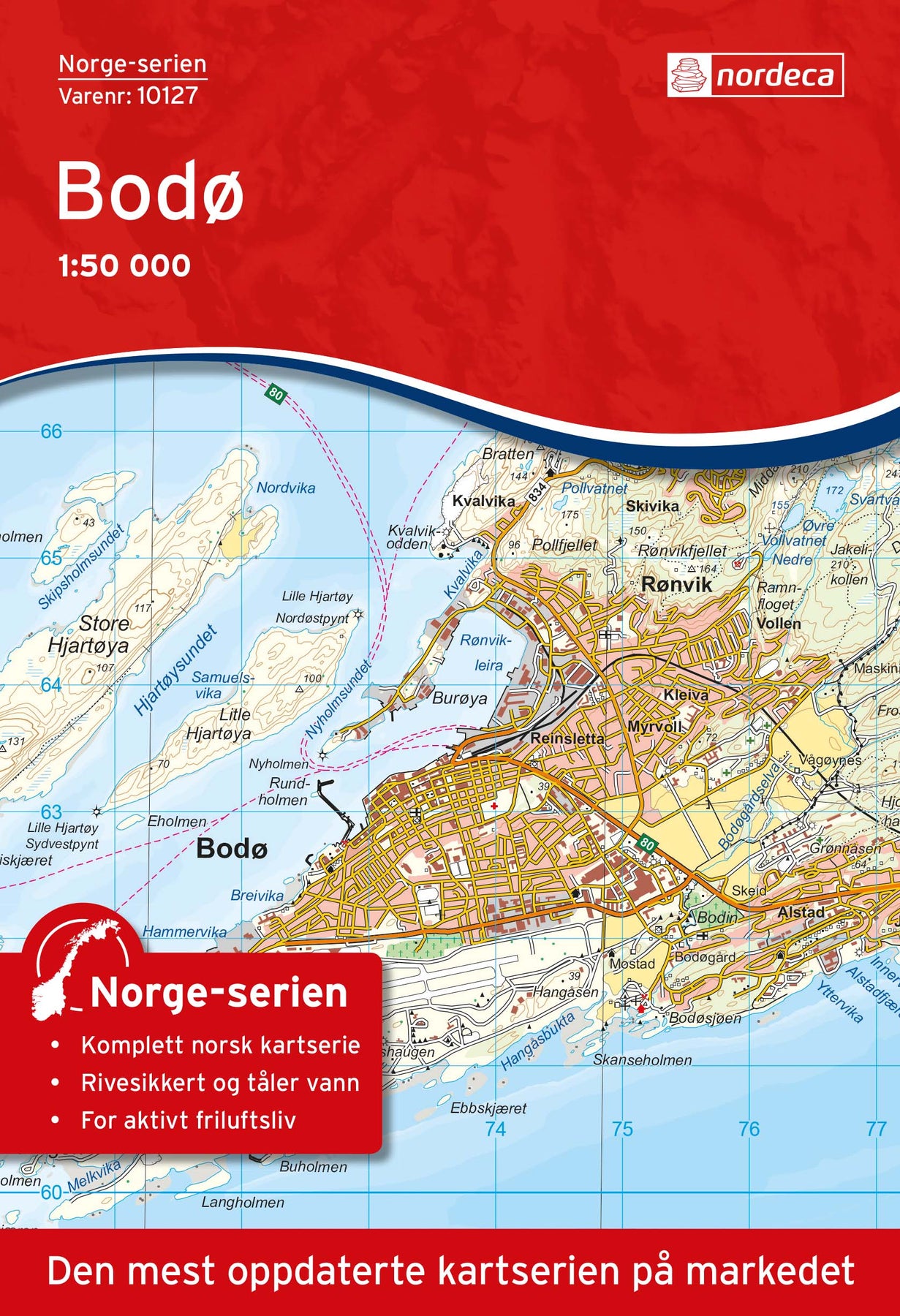
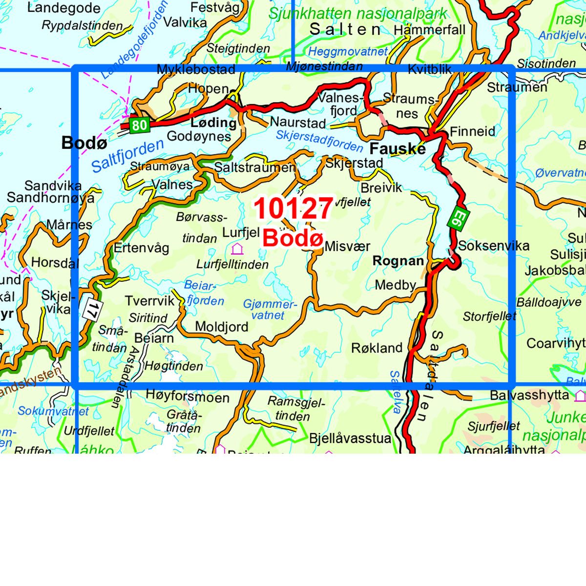
10127 Bodø
Ordinær pris 259,00 krNorge-serien er en landsdekkende kartserie i målestokk 1:50 000 som er godt egnet for korte og lange turer. Kartene er velegnet til tur- og fritidsbruk på fjellet, i skogen, langs kysten og til jakt og fiske. For profesjonelle virksomheter gir kartene nødvendig kunnskap om terreng og geografi for planlegging og utøvelse.
Hvert kart dekker et område på 47x64 kilometer, og det er 2 kilometer overlapp mellom kartbladene.
Kartene i norge-serien er trykket på et tynt plastfibermateriale som tåler vann og er vanskelig å rive i stykker. Kartene tåler store fysiske påkjenninger og vil være et perfekt kart for tur i all slags vær.
10125 Graddis
Ordinær pris 259,00 krNorge-serien er en landsdekkende kartserie i målestokk 1:50 000 som er godt egnet for korte og lange turer. Kartene er velegnet til tur- og fritidsbruk på fjellet, i skogen, langs kysten og til jakt og fiske. For profesjonelle virksomheter gir kartene nødvendig kunnskap om terreng og geografi for planlegging og utøvelse.
Hvert kart dekker et område på 47x64 kilometer, og det er 2 kilometer overlapp mellom kartbladene.
Kartene i Norge-serien er trykket på et tynt plastfibermateriale som tåler vann og er vanskelig å rive i stykker. Kartene tåler store fysiske påkjenninger og vil være et perfekt kart for tur i all slags vær.
Publisert år: 2018
Innbinding: falset
Material: plastfiber
Målestokk: 1:50000
10113 Brønnøysund
Ordinær pris 259,00 krNorge-serien er en landsdekkende kartserie i målestokk 1:50 000 som er godt egnet for korte og lange turer. Kartene er velegnet til tur- og fritidsbruk på fjellet, i skogen, langs kysten og til jakt og fiske. For profesjonelle virksomheter gir kartene nødvendig kunnskap om terreng og geografi for planlegging og utøvelse.
hvert kart dekker et område på 47x64 kilometer, og det er 2 kilometer overlapp mellom kartbladene.
kartene i norge-serien er trykket på et tynt plastfibermateriale som tåler vann og er vanskelig å rive i stykker. Kartene tåler store fysiske påkjenninger og vil være et perfekt kart for tur i all slags vær.
Publisert år: 2018
Innbinding: falset
Material: plastfiber
Målestokk: 1:50000
10111 Tosbotn
Ordinær pris 259,00 krNorge-serien er en landsdekkende kartserie i målestokk 1:50 000 som er godt egnet for korte og lange turer. Kartene er velegnet til tur- og fritidsbruk på fjellet, i skogen, langs kysten og til jakt og fiske. For profesjonelle virksomheter gir kartene nødvendig kunnskap om terreng og geografi for planlegging og utøvelse.
hvert kart dekker et område på 47x64 kilometer, og det er 2 kilometer overlapp mellom kartbladene.
kartene i norge-serien er trykket på et tynt plastfibermateriale som tåler vann og er vanskelig å rive i stykker. Kartene tåler store fysiske påkjenninger og vil være et perfekt kart for tur i all slags vær.
Publisert år: 2016
Innbinding: falset
Material: plastfiber
Målestokk: 1:50000
10109 Borgafjällen
Ordinær pris 259,00 kr Salgspris 50,00 kr Spar 81%Norge-serie kartet Borgarfjällen i målestokk 1:50 000 er trykket på et slitesterkt resirkulerbart plastfibermaterial som tåler vann. Kartet egner seg for turgåere, jegere, fiskere og brukes blant annet av redningskorpsene. Norge-serien er en landsdekkende kartserie og er derfor også populær for de som går lengre turer. Overlapp på alle kart gjør det enkelt å navigere mellom kartene.
10107 Innerfolda
Ordinær pris 259,00 kr10106 Vikna
Ordinær pris 259,00 krNorge-serien er en landsdekkende kartserie i målestokk 1:50 000 som er godt egnet for korte og lange turer. Kartene er velegnet til tur- og fritidsbruk på fjellet, i skogen, langs kysten og til jakt og fiske. For profesjonelle virksomheter gir kartene nødvendig kunnskap om terreng og geografi for planlegging og utøvelse.
hvert kart dekker et område på 47x64 kilometer, og det er 2 kilometer overlapp mellom kartbladene.
kartene i norge-serien er trykket på et tynt plastfibermateriale som tåler vann og er vanskelig å rive i stykker. Kartene tåler store fysiske påkjenninger og vil være et perfekt kart for tur i all slags vær.
Publisert år: 2017
Innbinding: falset
Material: plastfiber
Målestokk: 1:50000
10105 Gäddede
Ordinær pris 259,00 kr Salgspris 50,00 kr Spar 81%Norge-serien er en landsdekkende kartserie i målestokk 1:50 000 som er godt egnet for korte og lange turer. Kartene er velegnet til tur- og fritidsbruk på fjellet, i skogen, langs kysten og til jakt og fiske. For profesjonelle virksomheter gir kartene nødvendig kunnskap om terreng og geografi for planlegging og utøvelse.
hvert kart dekker et område på 47x64 kilometer, og det er 2 kilometer overlapp mellom kartbladene.
kartene i norge-serien er trykket på et tynt plastfibermateriale som tåler vann og er vanskelig å rive i stykker. Kartene tåler store fysiske påkjenninger og vil være et perfekt kart for tur i all slags vær.
Publisert år: 2012
Innbinding: falset
Material: plastfiber
Målestokk: 1:50000
10103 Høylandet
Ordinær pris 259,00 krNorge-serien er en landsdekkende kartserie i målestokk 1:50 000 som er godt egnet for korte og lange turer. Kartene er velegnet til tur- og fritidsbruk på fjellet, i skogen, langs kysten og til jakt og fiske. For profesjonelle virksomheter gir kartene nødvendig kunnskap om terreng og geografi for planlegging og utøvelse.
hvert kart dekker et område på 47x64 kilometer, og det er 2 kilometer overlapp mellom kartbladene.
kartene i norge-serien er trykket på et tynt plastfibermateriale som tåler vann og er vanskelig å rive i stykker. Kartene tåler store fysiske påkjenninger og vil være et perfekt kart for tur i all slags vær.
Publisert år: 2018
Innbinding: falset
Material: plastfiber
Målestokk: 1:50000
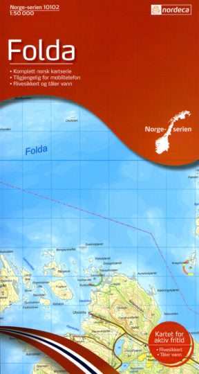
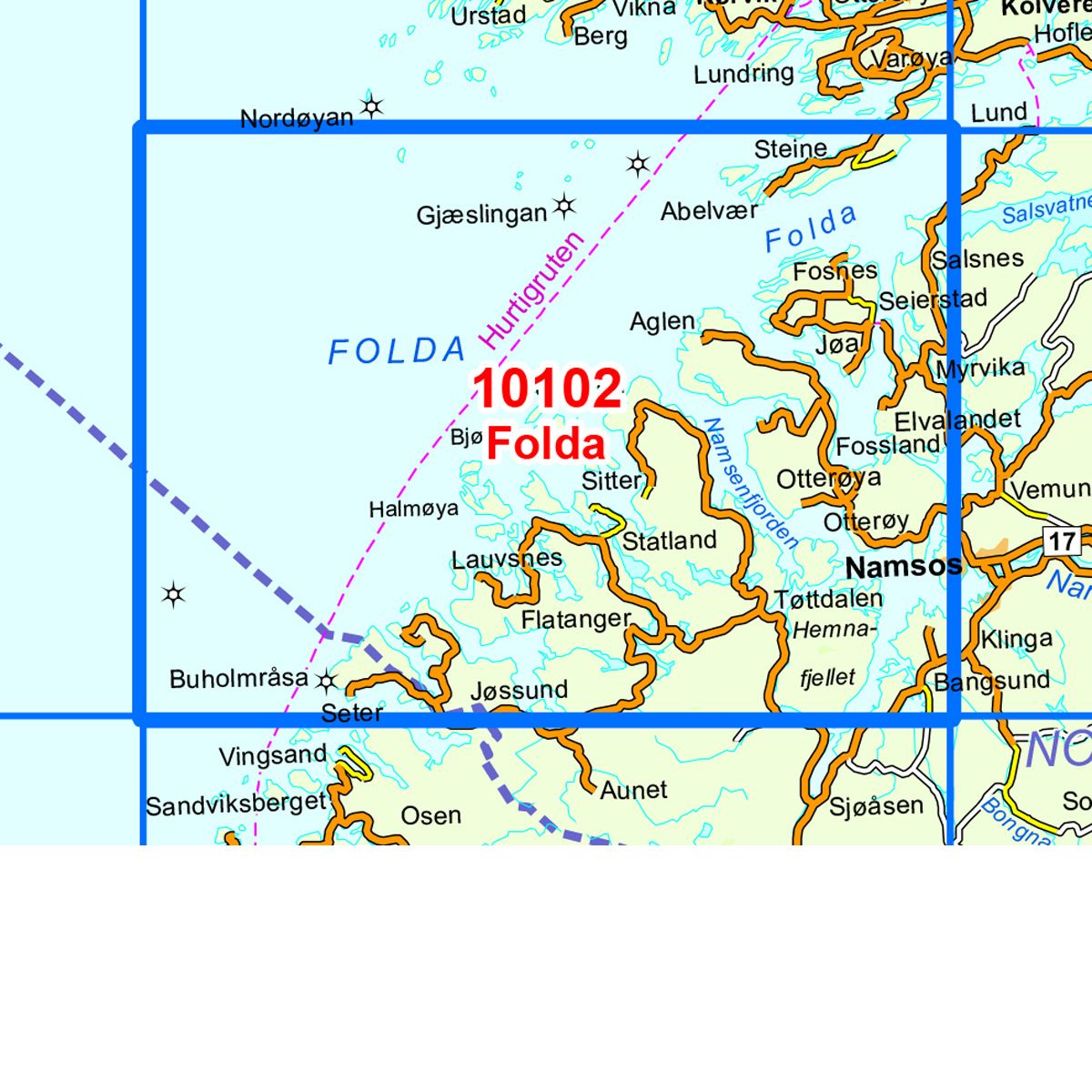
10102 Folda
Ordinær pris 259,00 krNorge-serien er en landsdekkende kartserie i målestokk 1:50 000 som er godt egnet for korte og lange turer. Kartene er velegnet til tur- og fritidsbruk på fjellet, i skogen, langs kysten og til jakt og fiske. For profesjonelle virksomheter gir kartene nødvendig kunnskap om terreng og geografi for planlegging og utøvelse.
hvert kart dekker et område på 47x64 kilometer, og det er 2 kilometer overlapp mellom kartbladene.
kartene i norge-serien er trykket på et tynt plastfibermateriale som tåler vann og er vanskelig å rive i stykker. Kartene tåler store fysiske påkjenninger og vil være et perfekt kart for tur i all slags vær.
Publisert år: 2016
Innbinding: falset
Material: plastfiber
Målestokk: 1:50000
10099 Snåsa
Ordinær pris 259,00 kr Salgspris 159,00 kr Spar 39%Norge-serie kartet Snåsa i målestokk 1:50 000 er trykket på et slitesterkt resirkulerbart plastfibermaterial som tåler vann. Kartet egner seg for turgåere, jegere, fiskere og brukes blant annet av redningskorpsene. Norge-serien er en landsdekkende kartserie og er derfor også populær for de som går lengre turer.
Overlapp på alle kart gjør det enkelt å navigere mellom kartene.
10092 Åre
Ordinær pris 259,00 krNorge-serien er en landsdekkende kartserie i målestokk 1:50 000 som er godt egnet for korte og lange turer. Kartene er velegnet til tur- og fritidsbruk på fjellet, i skogen, langs kysten og til jakt og fiske. For profesjonelle virksomheter gir kartene nødvendig kunnskap om terreng og geografi for planlegging og utøvelse.
hvert kart dekker et område på 47x64 kilometer, og det er 2 kilometer overlapp mellom kartbladene.
kartene i norge-serien er trykket på et tynt plastfibermateriale som tåler vann og er vanskelig å rive i stykker. Kartene tåler store fysiske påkjenninger og vil være et perfekt kart for tur i all slags vær.
Publisert år: 2018
Innbinding: falset
Material: plastfiber
Målestokk: 1:50000
10089 Kyrksæterøra
Ordinær pris 259,00 krNorge-serien er en landsdekkende kartserie i målestokk 1:50 000 som er godt egnet for korte og lange turer. Kartene er velegnet til tur- og fritidsbruk på fjellet, i skogen, langs kysten og til jakt og fiske. For profesjonelle virksomheter gir kartene nødvendig kunnskap om terreng og geografi for planlegging og utøvelse.
hvert kart dekker et område på 47x64 kilometer, og det er 2 kilometer overlapp mellom kartbladene.
kartene i norge-serien er trykket på et tynt plastfibermateriale som tåler vann og er vanskelig å rive i stykker. Kartene tåler store fysiske påkjenninger og vil være et perfekt kart for tur i all slags vær.
Publisert år: 2017
Innbinding: falset
Material: plastfiber
Målestokk: 1:50000
10082 Aukra
Ordinær pris 259,00 kr Salgspris 50,00 kr Spar 81%Norge-serien er en landsdekkende kartserie i målestokk 1:50 000 som er godt egnet for korte og lange turer. Kartene er velegnet til tur- og fritidsbruk på fjellet, i skogen, langs kysten og til jakt og fiske. For profesjonelle virksomheter gir kartene nødvendig kunnskap om terreng og geografi for planlegging og utøvelse.
hvert kart dekker et område på 47x64 kilometer, og det er 2 kilometer overlapp mellom kartbladene.
kartene i norge-serien er trykket på et tynt plastfibermateriale som tåler vann og er vanskelig å rive i stykker. Kartene tåler store fysiske påkjenninger og vil være et perfekt kart for tur i all slags vær.
Publisert år: 2012
Innbinding: falset
Material: plastfiber
Målestokk: 1:50000
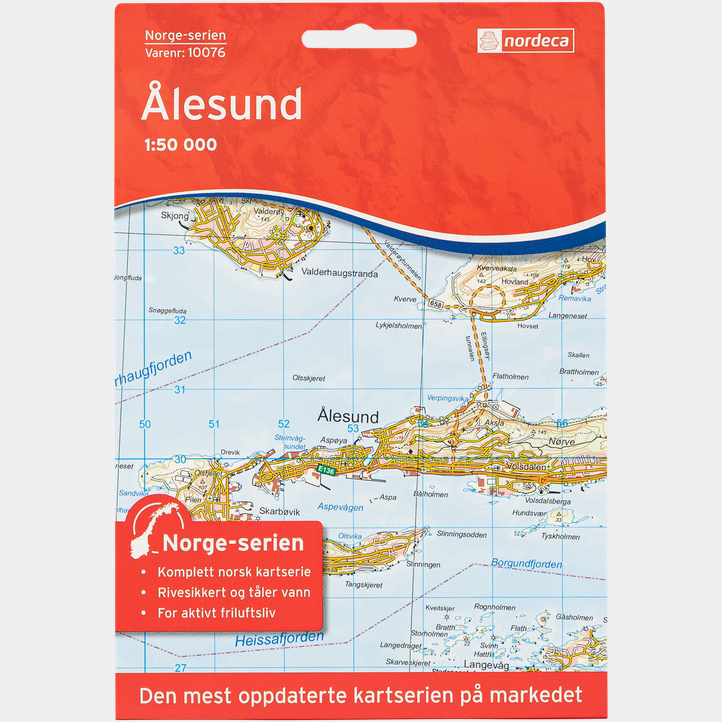
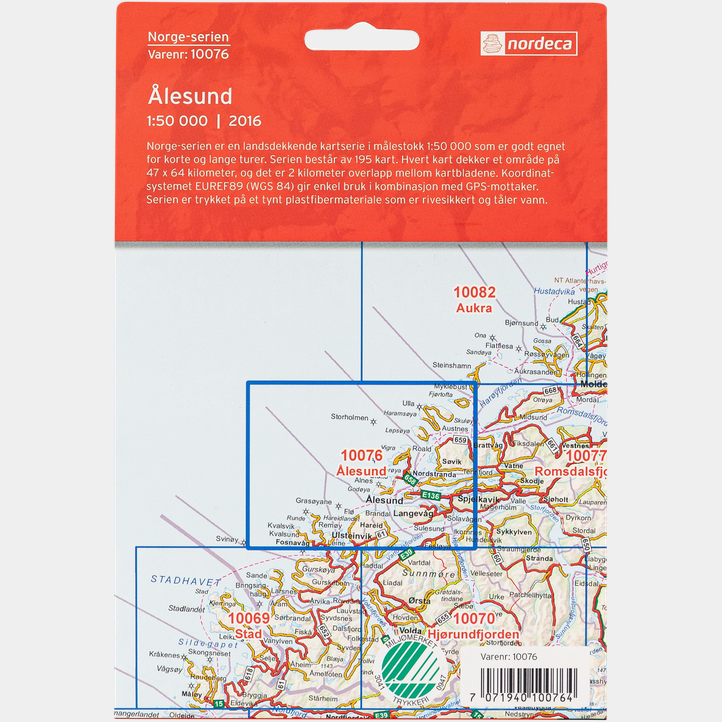
10076 Ålesund
Ordinær pris 259,00 kr Salgspris 159,00 kr Spar 39%Norge-serien er en landsdekkende kartserie i målestokk 1:50 000 som er godt egnet for korte og lange turer. Kartene er velegnet til tur- og fritidsbruk på fjellet, i skogen, langs kysten og til jakt og fiske. For profesjonelle virksomheter gir kartene nødvendig kunnskap om terreng og geografi for planlegging og utøvelse.
hvert kart dekker et område på 47x64 kilometer, og det er 2 kilometer overlapp mellom kartbladene.
kartene i norge-serien er trykket på et tynt plastfibermateriale som tåler vann og er vanskelig å rive i stykker. Kartene tåler store fysiske påkjenninger og vil være et perfekt kart for tur i all slags vær.
Publisert år: 2016
Innbinding: falset
Material: plastfiber
Målestokk: 1:50000
10074 Raudsjøen
Ordinær pris 259,00 krNorge-serien er en landsdekkende kartserie i målestokk 1:50 000 som er godt egnet for korte og lange turer. Kartene er velegnet til tur- og fritidsbruk på fjellet, i skogen, langs kysten og til jakt og fiske. For profesjonelle virksomheter gir kartene nødvendig kunnskap om terreng og geografi for planlegging og utøvelse.
hvert kart dekker et område på 47x64 kilometer, og det er 2 kilometer overlapp mellom kartbladene.
kartene i norge-serien er trykket på et tynt plastfibermateriale som tåler vann og er vanskelig å rive i stykker. Kartene tåler store fysiske påkjenninger og vil være et perfekt kart for tur i all slags vær.
Publisert år: 2017
Innbinding: falset
Material: plastfiber
Målestokk: 1:50000
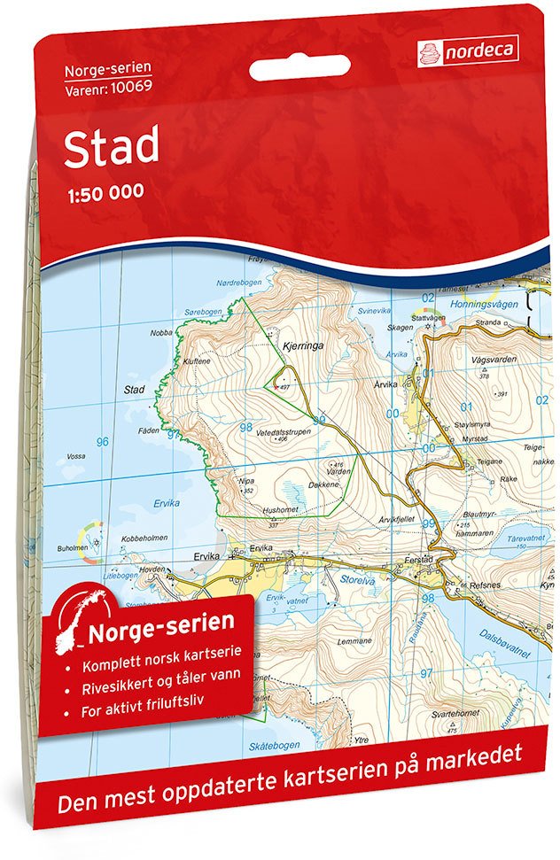
10069 Stad
Ordinær pris 259,00 krNorge-serien er en landsdekkende kartserie i målestokk 1:50 000 som er godt egnet for korte og lange turer. Kartene er velegnet til tur- og fritidsbruk på fjellet, i skogen, langs kysten og til jakt og fiske. For profesjonelle virksomheter gir kartene nødvendig kunnskap om terreng og geografi for planlegging og utøvelse.
Hvert kart dekker et område på 47x64 kilometer, og det er 2 kilometer overlapp mellom kartbladene.
Kartene i Norge-Serien er trykket på et tynt plastfibermateriale som tåler vann og er vanskelig å rive i stykker. Kartene tåler store fysiske påkjenninger og vil være et perfekt kart for tur i all slags vær.
10061 Florø
Ordinær pris 259,00 krNorge-serien er en landsdekkende kartserie i målestokk 1:50 000 som er godt egnet for korte og lange turer. Kartene er velegnet til tur- og fritidsbruk på fjellet, i skogen, langs kysten og til jakt og fiske. For profesjonelle virksomheter gir kartene nødvendig kunnskap om terreng og geografi for planlegging og utøvelse.
hvert kart dekker et område på 47x64 kilometer, og det er 2 kilometer overlapp mellom kartbladene.
kartene i norge-serien er trykket på et tynt plastfibermateriale som tåler vann og er vanskelig å rive i stykker. Kartene tåler store fysiske påkjenninger og vil være et perfekt kart for tur i all slags vær.
Publisert år: 2017
Innbinding: falset
Material: plastfiber
Målestokk: 1:50000
10053 Askvoll
Ordinær pris 259,00 krNorge-serien er en landsdekkende kartserie i målestokk 1:50 000 som er godt egnet for korte og lange turer. Kartene er velegnet til tur- og fritidsbruk på fjellet, i skogen, langs kysten og til jakt og fiske. For profesjonelle virksomheter gir kartene nødvendig kunnskap om terreng og geografi for planlegging og utøvelse.
hvert kart dekker et område på 47x64 kilometer, og det er 2 kilometer overlapp mellom kartbladene.
kartene i norge-serien er trykket på et tynt plastfibermateriale som tåler vann og er vanskelig å rive i stykker. Kartene tåler store fysiske påkjenninger og vil være et perfekt kart for tur i all slags vær.
Publisert år: 2020
Innbinding: falset
Material: plastfiber
Målestokk: 1:50000
10045 Fedje
Ordinær pris 259,00 kr10016 Hjelmeland
Ordinær pris 259,00 krNorge-serie kartet Hjelmeland i målestokk 1:50 000 er trykket på et slitesterkt resirkulerbart plastfibermaterial som tåler vann. Kartet egner seg for turgåere, jegere, fiskere og brukes blant annet av redningskorpsene. Norge-serien er en landsdekkende kartserie og er derfor også populær for de som går lengre turer. Overlapp på alle kart gjør det enkelt å navigere mellom kartene.
10015 Haugesund
Ordinær pris 259,00 kr10006 Evje
Ordinær pris 259,00 kr10002 Kristiansand
Ordinær pris 259,00 kr3045 Dalane
Ordinær pris 259,00 kr3041 Sogndal Leikanger
Ordinær pris 259,00 kr3040 Gaurlarfjellet
Ordinær pris 259,00 kr3039 Sunnfjord
Ordinær pris 259,00 kr