479 produkter
Greece: Corfu
Ordinær pris 169,00 krTysk kartserie med flotte kart på slitesterkt plastpapir.
Reise Know-How maps (world mapping project series) are easy-to-read, waterproof and highly durable travel maps specifically designed for everyday use on the road.
The maps combine state-of-the-art, GPS-compatible cartography (including hypsometric tints and contour lines) with a detailed rendering of road networks and touristic information. They offer the best possible scale, level of detail and readability, be it a map of a small island or half a continent.
The maps feature a detachable paper sleeve so that the maps can be folded easily and fit in every pocket. Although printed on plastic, a special coating makes sure the maps retain a paper-like feel and can even be written on with a pencil.
Greece: Crete; Mykonos & Santorini
Ordinær pris 169,00 krThe many islands off the coast of Greece can only be mapped properly a few at a time. Side 1 of this map shows the large island of Crete in good detail, with the relatively nearby island of Mykonos and its adjacent island of Rinia and the island of Santorini, with its adjacent islands of Thirasia and Nea Kameni being shown in great detail. A locality map showing the islands in relation to the rest of Greece is included as an inset. It is our intention to map more islands as time passes, but this depends upon future research trips (we lead a hard life!).
Side 2 of the map is a general map of Greece in relation to its neighbours to the north and east. The Mediterranean is divided into smaller seas, such as the Adriatic along the coast of Croatia, the Ionian to the west of Greece, the Myrtoan to its south and the Aegean to its east. All this area is replete with islands and geopolitical conflicts. As such, this map is useful for showing the region as an entity that links the Balkan states to the eastern Mediterranean.
Greece: Lesbos (lesvos)
Ordinær pris 189,00 kr Salgspris 94,50 kr Spar 50%Dette store østerriske kartforlaget er kjent for sin klare kartografi og gode papirkvalitet. De kommer i alle målestokker, og flere av landkartene inneholder bykart og turistinformasjon.
Lesbos at 1:50,000 on an indexed, GPS compatible map from Freytag & Berndt with brief descriptions of places of interest highlighted on the map, plus a street plan of Mitilini. The map is double-sided, dividing the island east/west, with a very generous overlap between the sides.
Topography of the island is shown by bold relief shading, enhanced by contours at 40m intervals. All place names are given in both Greek and Latin alphabet. Road network includes small local roads and selected cart tracks, showing driving distances on main and secondary routes. Ferry connections are marked.
The island’s best sights are prominently highlighted and provided with brief multilingual descriptions in a booklet attached to the map cover. Various other places of interest are marked and named on the map, including numerous beaches and churches/monasteries.
The map has a UTM grid, plus latitude and longitude margin ticks. The index, placed in the booklet, provides GPS waypoints for all the locations listed in it. Multilingual map legend includes English.
Publisert år: 2018
Innbinding: falset
Material: papir
Målestokk: 1:50000
Inland Waterways of France
Ordinær pris 249,00 krFirst published in the 1950s under the editorship of EE Benest and later Konrad Nussbaum, the Imray map of the French inland waterway system has always been regarded as the essential reference for planning a visit to France by boat. It is now superseded by this completely recompiled and redrawn edition by David Edwards-May, the leading authority on World canals and waterways. The new cartography includes improved detail and presents essential information concerning distances and dimensions with a greater clarity than on previous editions.
The map continues to cover the Low Countries and the western part of Germany and now also includes large scale insets of the Paris region and northeast France. The scale remains at 1:1 500 000
Ireland South
Ordinær pris 299,00 krLonely Planet Italy
Ordinær pris 119,00 krLonely Planet Planning Map er slitesterkt og vanntett, med en hendig slipcase og et format som er enkelt å brette. Få mer ut av kartet og reisen din med bilder og informasjon om toppattraksjoner i landet, reiseruteforslag, en transportguide, planleggingsinformasjon, temalister og praktiske reisetips. Med dette brukervennlige navigasjonsverktøyet i baklommen kan du virkelig komme til hjertet av din destinasjon!
Italy: Emilia-Romagna
Ordinær pris 199,00 krThis detailed road map of Emilia-Romagna - Bologna is very suitable for planning and traveling around the country. The road network is well represented, both the main roads, provincial and local roads. Road numbers are also clearly stated.
Distances between places are marked on the map in kilometers, and gas stations are also marked in important places. Shadow shows the relief and sometimes some points with the actual height. Province borders, national parks and reserves are easy to find.
Symbols indicate the location of tourist sites, monuments, historically important places and viewpoints. In certain places you can find hotels and campsites, airports, train connections and ports.
Italy: Friuli Julian March - Udine; Trieste & Venice
Ordinær pris 199,00 krItalian region of Friuli–Venezia Giulia at a detailed scale of 1:150,000 on a map in Freytag & Berndt’s very popular “Top 10 Tips” series. A booklet attached to the map cover provides descriptions of the region’s 10 best sights, a street plan of central Trieste, plus the map index. Many place names are in large print to make navigating easier. Coverage extends west to Belluno and Treviso, and south-west to include the Venice Lagoon with Venice and Chioggia.
Maps in this series have topography well presented by subtle hill-shading with spot heights, plus colouring for woodlands; national and regional parks are highlighted. Road network emphasizes motorways and regional roads, but also includes small local roads and selected country tracks, most annotated with driving distances. Scenic routes are highlighted and the maps show roads closed to motor vehicles and/or not recommended for caravans, winter closures, toll routes, etc. Names of larger local towns are in bold print, making navigating in unfamiliar terrain much easier. Railway lines and ferry routes are included and local airports are marked.
Picturesque locations are highlighted and in each title 10 best places of interest are prominently marked and briefly described in a booklet attached to the map cover. Symbols indicate various landmarks and facilities, e.g. archaeological sites, churches and castles, campsites, hostels, etc. Latitude and longitude lines are drawn at 10' intervals. The index, listing all the localities with their postcodes, is in the booklet attached to the map cover. The booklet also provides street plan (s) of the region’s main town(s). Map legend and the descriptions include English.
Italy: Liguria
Ordinær pris 199,00 krItaly: Pustertal Dolomiten
Ordinær pris 209,00 krDette store østerriske kartforlaget er kjent for sin klare kartografi og gode papirkvalitet. De kommer i alle målestokker, og flere av landkartene inneholder bykart og turistinformasjon.
Italy: Sardinia
Ordinær pris 199,00 krIndexed, waterproof and tear-resistant road map of Sardinia at 1:200,000 with topographic and tourist information, published by Reise Know-How as part of their highly acclaimed World Mapping Project. The map is double-sided, with a good overlap, to provide the best balance between a good scale and a convenient size sheet.
Topography is indicated by altitude colouring with spot heights and names of mountain ranges. Road information includes local tracks, indicates driving distances on main and secondary roads, and highlights scenic routes. Railways and ferry connections are also shown. Extensive overprint indicates locations of numerous nuraghi/nuraghes, the main type of megalithic edifices found in Sardinia, dating back before 1000 BC and today a symbol of the island’s distinctive culture. The overprint also highlights local national parks, holiday camps, campsites and mountain refuges, viewpoints, prehistoric monuments, churches and castles, beaches, golf courses, etc. The map has a 10km UTM grid, plus latitude and longitude grid at 10’ intervals. Map legend includes English.
Jämtlandsfjällan
Ordinær pris 249,00 kr Salgspris 199,00 kr Spar 20%Kalimnos
Ordinær pris 169,00 kr Salgspris 84,50 kr Spar 50%KANGAATSIAQ
Ordinær pris 219,00 krKANGERLUARSORUSEQ QEQERTARSUATSIAAT
Ordinær pris 179,00 krKefalonia
Ordinær pris 229,00 krKefalonia was popularised and made famous by Captain Corelli's Mandolin. For your best adventures, use the best map. Water-proof, split-proof, tear-proof, adventure-proof.
Kefalonia and Ithaca Tour and Trail Super Durable Map is simply the toughest, most accurate, easy to read, easy to use map of the island you can buy at any price. A large 960mm by 690mm double sided map sheet has both Kefalonia and Ithaca at 1:40,000 scale with the North-West of Kefalonia on the cover side and the South-East of Kefalonia with neighbouring island Ithaca on the reverse. A generous common overlap of Kefalonia reduces the need to turn the map over when navigating.
Our special concertina map fold makes your map easy to open and easy to refold to its 230mm by 120mm pocket size. Our legendary 'Tour & Trail' level of detail ranges from major roads to secondary roads to minor roads to streets and narrow country roads, plus dirt roads, tracks and walking trails. Place names are in English and Greek to aid your navigation.
Altitude shading is designed to clearly show the altitude range when travelling across the island by car or on foot. 20 metre and 100 metre contours combined with altitude shading bring this beautiful landscape to life. There are plenty of individual height points and all of the official Trig points are on the map.
Tour and Trail attention to detail includes our useful symbol range including viewpoints, picnic areas, petrol stations, bar/restaurants and parking areas where you can pull off the road safely. You will easily identify springs, caves, sports grounds, cemeteries, monasteries, churches, chapels, lighthouses, castles, camping areas, wind turbines, hotels etc. Published walking routes are clearly highlighted on the map.
It all adds up to the most detailed and most durable map of Kefalonia and Ithaca that you can buy anywhere. Super Durable means a waterproof, tear-proof, map that can take the roughest treatment and still folds up like new after your adventures. Super Durable Maps come with a 2 year adventurous use Wear and Tear guarantee.
Digital editions of our Kefalonia and Ithaca Tour and Trail Map are available for phone apps and Garmin users from our Discovery Walking Guides website.
Publisert år: 2020
Innbinding: fal
Material: 0
Målestokk: 1:40 000
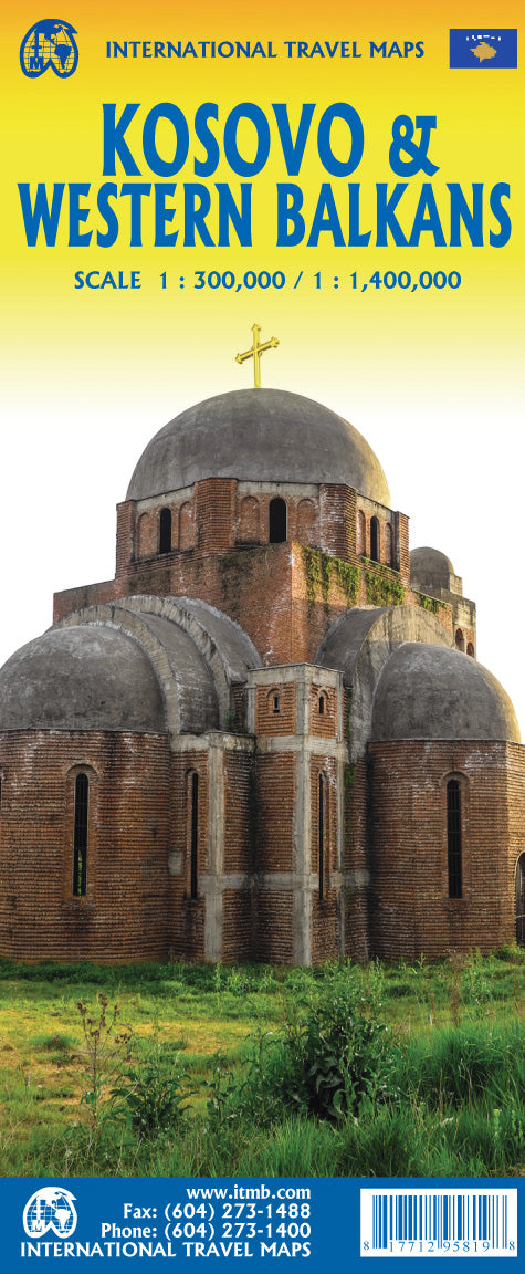
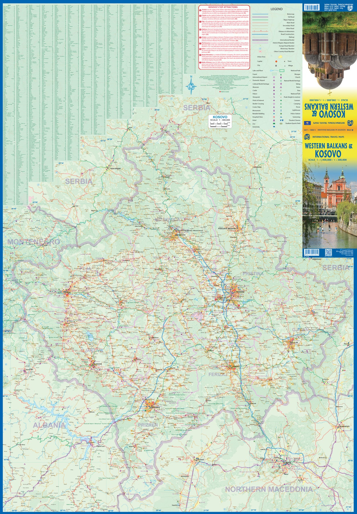
Kosovo
Ordinær pris 199,00 krKosovo at 1:150,000 on a large map in Freytag & Berndt’s “Top 10 Tips” series with the index booklet also providing multilingual descriptions of the country’s most interesting locations. Where appropriate, place names are bilingual, with Serbian names shown in Latin alphabet only (within Serbia itself and Macedonia place names are in both Cyrillic and Latin alphabets).
The map is an enlargement of F&B’s mapping of the region at a smaller scale, so all names are in much larger print size than found on similar maps. Topography is presented by relief shading with colouring for forested areas, plus names of various mountain ranges and peaks. Road network includes small local roads and selected cart tracks. Driving distances are marked on main routes and scenic roads are highlighted. Railway lines are shown with stations. Various places of interest, including the publishers’ recommendations are highlighted. Latitude and longitude lines are drawn at 10’ intervals. Multilingual map legend includes English.
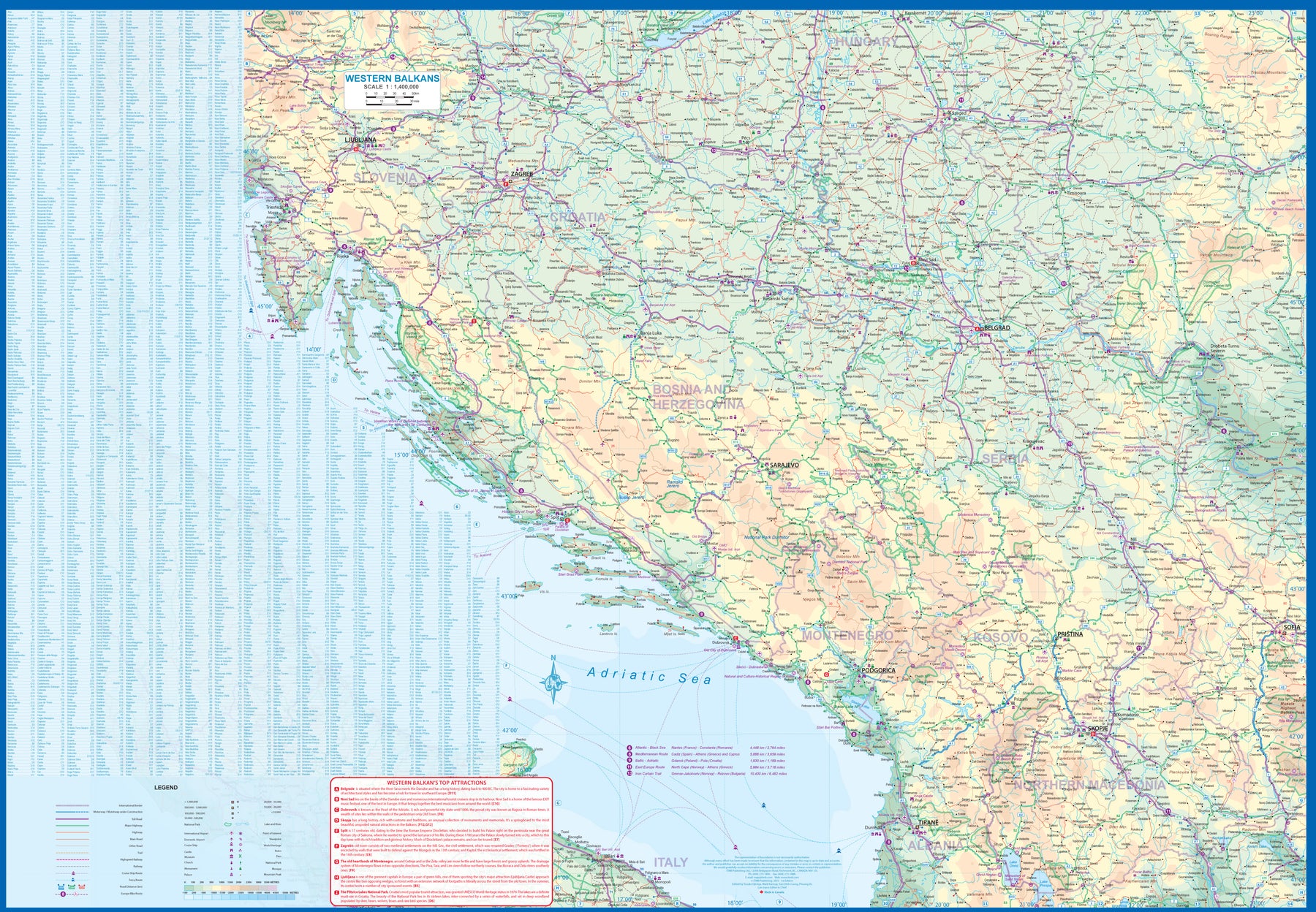
Kosovo & Western Balkans
Ordinær pris 199,00 krKosovo is the country that shouldn't exist, but does. When Yugoslavia fell to pieces after Tito died, Kosovo was lumped in with Serbia but was very unhappy with being a part of an Eastern Orthodox regime. It broke away, resulting in genocidal fighting until the Americans stepped in and stopped the fighting. The region was then placed under a European Union control in the faint hope that it would merge with Albania, or Montenegro, but it didn't. Relations with Serbia are still quite strained, but Kosovo is still surviving as a mountainous Balkan state. Fought over for centuries by Turks and Serbs, Kosovo is emerging as a small but touristic European country. This is definitely an off-the-beaten-path travel destination!
The second side of the sheet provides an excellent regional coverage for the Western Balkans, essentially Slovenia, Croatia, Montenegro, Serbia, and reasonably large tracks of land for Hungary, Albania, and North Macedonia, showing the growing number of wilderness parks being created.
La Palma Caldera de Taburiente
Ordinær pris 199,00 krLanzarote
Ordinær pris 119,00 krMarco Polo er svært detaljerte kart som er praktiske og enkle i bruk. 7 klistremerker for å markere spesifikke steder gjør det enda enklere å planlegge reisen. Alle kartene inneholder en omfattende index for enkelt å finne frem.
Lanzarote
Ordinær pris 229,00 krLanzarote Tour & Trail Map covers this big island at a scale of 1:40,000 resulting in the most detailed and toughest map of Lanzarote that you can buy.
We have also included a full island map of La Graciosa at 1:40,000 scale for those people adventuring or staying on the island. Getting such a large island onto one map sheet at 1:40,000 scale means that we have had to split the island into a North-East section on one side and a South-West section on the other side, with a generous overlap between the sections.
In addition to the usual high level of detail on our "Tour & Trail Maps" we have introduced special 'lava' fills to define the lava fields and a 'zocos' fill to define the famous La Geria region. The result is the definitive map of Lanzarote. Super-Durable version is produced on a special polymer substrate using 100% oxygenation inks which results in a map that is virtually tear proof, water proof, baby proof, almost dog proof and will outlast any paper map many times over.
Lefkada, Paxos & Antipaxos
Ordinær pris 229,00 krVanntett og holdbart turkart over Lefkas, Paxos og Antipaxos.
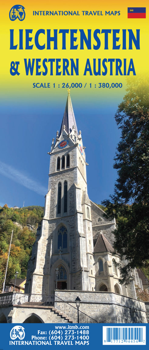
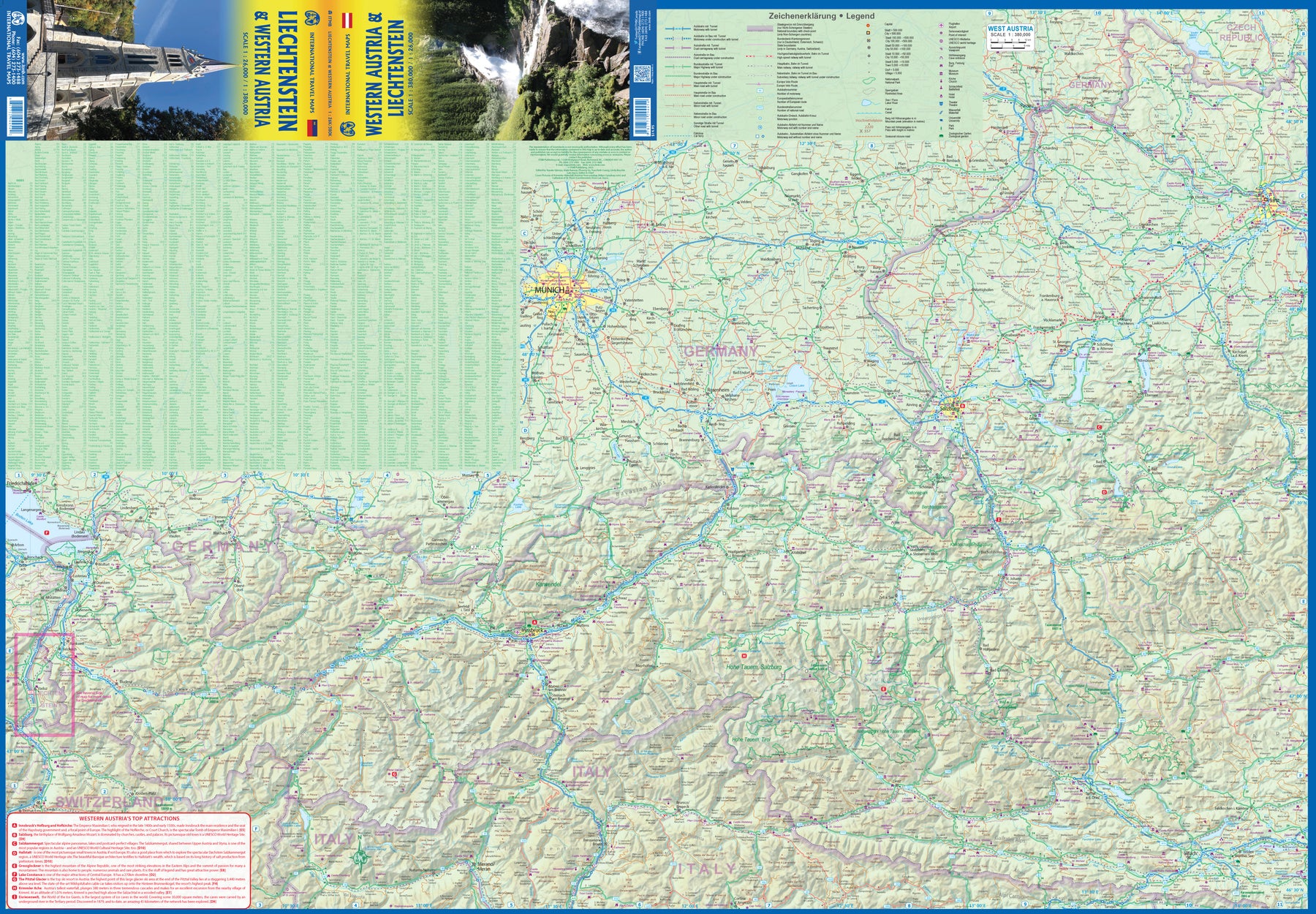
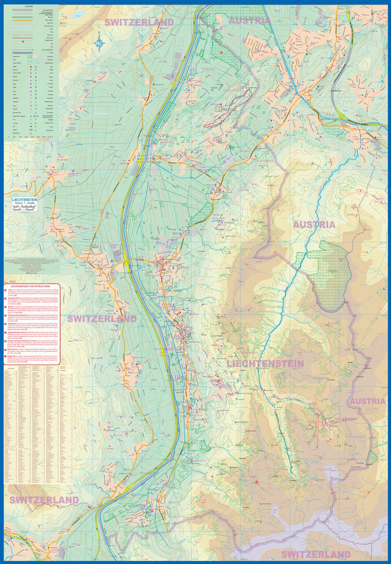
Liechtenstein & Western Austria
Ordinær pris 179,00 krEurope is dotted with mini-states that exist solely for historic reasons but are fiercely independent. Liechtenstein, surrounded by Switzerland on its west and south and Austria on its other borders, is such a state. It is larger and more diverse than many imagine and is quite a popular ski resort region. Side 1 is a detailed map of the principality, framed on the west by the Rhine River and a bit of Switzerland and on the east by Austria. Most development occurs in the Rhine Valley in a north-south direction, dominated by the capital city of Vaduz. There are five access points from Switzerland across the Rhine, one from the south, and two from Austria in the north. The ski haven of Malbun is prominently shown, and the scale of the map is detailed enough to name every major street. This also enabled us the opportunity to include schools, shopping areas, post offices, and churches, as well as a wide range of eating establishments. Walking/hiking trails have also been included.
This is the only map of Liechtenstein ever produced by a cartographic firm, and joins Andorra, Luxembourg, and Monaco as a valued part of ITMB's coverage of Europe. Side 2 concentrates on eastern Austria and southern Germany from Lake Boden (Bodensee) to Linz and from the Italian border north to Passau, in Germany. It is both a road/rail map and a physical relief map of this portion of the Alps. It includes its own Top Attractions list. Border crossings are shown merely as a formality, except for Switzerland. This would be an excellent map to use to explore the mountains south of Innsbruck or to discover small villages in the Tirol.
Lonely Planet Lisbon
Ordinær pris 119,00 krLonely Planet City Map er slitesterkt og vanntett, med en hendig slipcase og et format som er lett å brette. Få mer ut av kartet og reisen din med bilder og informasjon om byattraksjoner, transportkart, reiseruteforslag, omfattende gate- og nettstedsindeks og praktiske reisetips. Med dette brukervennlige navigasjonsverktøyet i baklommen kan du virkelig komme til hjertet av din destinasjon!
Lombardy
Ordinær pris 189,00 krMarco Polo er svært detaljerte kart som er praktiske og enkle i bruk. 7 klistremerker for å markere spesifikke steder gjør det enda enklere å planlegge reisen. Alle kartene inneholder en omfattende index for enkelt å finne frem.
Lonely Planet London
Ordinær pris 119,00 kr