109 produkter
109 produkter


109 produkter
Togo & Benin
Ordinær pris 169,00 krITM har kart over hele verden og de spesialiserer seg på land litt utenfor allfarvei. Beliggenheten til landets nasjonalparker, historiske monumenter, de viktigste veiene og lignende finner du inkludert i kartene. Samtlige landkart har ofte et bykart over hovedstaden.
Fra ITM: The two small countries squeezed between Ghana on the west and Nigeria on the east developed out of the European colonialization of most of Africa Germany, under Kaiser Bill, was determined to create an empire to rival that of Britain, and seized a portion of the coastline close to the British-held area of Ghana and held on to it until WW1 ended Germany’s colonial aspirations. Britain and France jointly governed Togo briefly, but the territory was ceded to France until independence was granted in the 1960s. Neighbouring Benin (formerly the French colony of Dahomey) was all that the French colonial office could obtain of the rich coastal plain until the German defeat in WW1, which gained it Togo and German Cameroun, further to the east. Both countries have their points of interest, but to this day have little to do with each other. There is one border crossing on the coast, and a couple of others much farther inland, but each country operates on a north-south basis, not an east-west one. The map includes inset maps of Lome, the capital of Togo, and Porto Novo, in Benin, which is now the capital. Togo’s best sites are noted in a red inset box, with a separate box for Benin.
United Arab Emirates & Abu Dhabi
Ordinær pris 169,00 krITM har kart over hele verden og de spesialiserer seg på land litt utenfor allfarvei. Beliggenheten til landets nasjonalparker, historiske monumenter, de viktigste veiene og lignende finner du inkludert i kartene. Samtlige landkart har ofte et bykart over hovedstaden.
We are pleased to release this brand new ITMB title. Abu Dhabi is one of the leading Emirates that are rapidly becoming vacation heavens for Europeans who don't want the long flights to Asian destinations. The city is so modern it almost squeaks. The palace is a world-class wonder, the seafront Corniche is a marvelous beach, and the central shopping area offers everything from hamburgers to Gucci bags. Motorways now connect the city state to nearby Dubai and to Oman, with a recently-completed one along the coastline to the Saudi border.
The reverse side of the map is an updated edition of the entire United Arab Emirates and most of Oman, with new motorways seemingly everywhere. A large inset map of central Dubai is included, along with a good one of Muscat. We docked at Abu Dhabi's cruise ship terminal during our visit and were impressed by the extent of urbanization of the city.
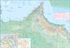
United Arab Emirates & Dubai
Ordinær pris 199,00 krITM har kart over hele verden og de spesialiserer seg på land litt utenfor allfarvei. Beliggenheten til landets nasjonalparker, historiske monumenter, de viktigste veiene og lignende finner du inkludert i kartene. Samtlige landkart har ofte et bykart over hovedstaden.
Fra ITM: Dubai is truly becoming a very popular travel destination and the loose federation of sheikdoms collectively known as the United Arab Emirates is growing in popularity with each passing year. Despite the turmoil affecting both Israel and Iran, this part of the Middle East is open for business and peaceful. Side 1 concentrates on the overall region from the eastern border of the UAE to its interaction with Oman. It also has an excellent inset map of Abu Dhabi, the capital of the UAE. Side 2 concentrates on Dubai itself as the largest urban area. Dubai has an extensive and interesting old town on the east bank of the Dubai Creek, which is where most of the hotels and the huge international airport are located. The ‘new town’ is on the left bank, and this is where one finds Western-style shopping areas, high-rise towers, the rapid transit line, and the main motorway out of town. The World Trade Center and Emirates Towers are also centrally located. The man-made Coastal Projects are shown in insets.
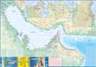
United Arab Emirates & Gulf Cruising
Ordinær pris 169,00 krITM har kart over hele verden og de spesialiserer seg på land litt utenfor allfarvei. Beliggenheten til landets nasjonalparker, historiske monumenter, de viktigste veiene og lignende finner du inkludert i kartene. Samtlige landkart har ofte et bykart over hovedstaden.
From ITMB: The Gulf, in this case, is the Persian Gulf, or if you prefer, the Arabian Gulf or, if you wish to, the Iranian Gulf. Regardless of which name one prefers, it is the body of water between Iran and the Arabic Emirates of Bahrain, Qatar, Dubai, and Oman/Muscat. It is also a popular cruising locale, with ships operating from Dubai to various ports of call. It also covers a considerable amount of geography, so side 1 concentrates on the water area from Kuwait/Iraq/Iran south to Bahrain and Qatar, along the coastline of the UAE to Oman and the Straits of Hormus, and along the coast of Oman to Muscat. It also includes inset maps of Manama (Bahrain), and Doha (Qatar), for the convenience of users. The second side of the map shows all of the United Arab Emirates and most of Oman, with insets of central Dubai and Muscat. Each side includes a listing of the top attractions of the side being shown. This is the third of ITMB’s growing range of cruising maps. We believe that the future of travel includes cruises as a popular means of exploring exotic travel destinations while retaining a comfortable environment. My wife and I cruised the Gulf a couple of years ago and found cruising to be an excellent way to explore several different countries that would be difficult to reach in any other manner. One day, I hope that cruises in this part of the world will extend to ports of call in Kuwait, Iraq, and Iran.
USA: Appalachian Trail
Ordinær pris 99,50 krThis is a new venture for ITMB, although we have published several recreational hiking maps over the years. The Appalachian mountain range was the original western boundary of the American colonies while under British rule. Everything west of there was technically the French possession of Louisiana Territory, called by American settlers ‘Indian country’. Nowadays, it is a massive recreational hinterland for east coast residents wanting to escape overcrowded cities. The National Parks Service maintains the trail and a series of overnight huts.
Most people only hike a portion of the trail, but for the dedicated hiker, the trail is a great adventure. We have divided the length of the trail into four natural regions: Maine into New York State, Connecticut south to Maryland, Maryland to Virginia, and Virginia to Georgia, to its traditional end at Springer Mountain. This is a demanding trail hike, but one of the most popular in the world.
USA: Arizona & New Mexico
Ordinær pris 169,00 krThis version includes two separate covers, one for each state, to enhance marketing possibilities, and the addition of two Top Attractions listings, one for each state. The Arizona side has a detailed inset map of Flagstaff, showing the path of Route 66 through the city streets. The New Mexico side includes a large inset of Albuquerque, also including the Route 66 passageway through the city.
USA: California
Ordinær pris 199,00 krThe American State of California has almost as many residents as all of Canada. I wonder how many of them are ex-pat Canucks? Regardless, this double-sided map shows the attractions of the state in amazing detail. Side 1 concentrates on the northern half, with a large inset map of San Francisco. A fairly large portion of Nevada shows as well, but with less detail.
Side 2 continues south to the Mexican border and east to Arizona, with a detailed inset map of central Los Angeles included. By the shape of California, all of southern Nevada is included as well, including the all-important wasteland of Las Vegas. All motorways are clearly shown, including those in greater Los Angeles. All state highways are also shown, as well as most secondary connecting roads. Parks, points of interest, beaches, redwood forests, and distances between major communities are also shown. The state is blessed with interesting offshore islands, such as Catalina, San Clemente, and the Channel Islands, all of which are included.
USA: Hawaii - Maui; Kauai & Molokai
Ordinær pris 199,00 krThe island of Maui may not be at well-known as Oahu, which is extremely popular with Japanese honeymooners, but it is as attractive touristically. Our coverage covers most of Side 1 and includes a detailed inset map of Wailuku, the principal urban area, as well as insets of Lahaina on the west coast and Wailea resort area. This side also includes a map of the island of Lanai, with its main urban area of Lanai City as an inset.
Side 2 concentrates on the islands of Molokai, Kauai, and the lightly populated island of Ni’ihau, and includes detailed inset maps of Lihue, Kaunakakai, and Po’ipu, all of which are major resort destinations. The islands are loaded with beaches and places to stay, but also with attractions, which are shown on the map. This is a beautiful map, one of the best we have ever produced, and is a fitting companion to our maps of Big Island, and Oahu/Honolulu, as well as our state map. The Maui/Kauai map also has a double-sided cover, so can be displayed as two separate maps.
USA: Hawaii Volcanoes National Park & Big Island
Ordinær pris 199,00 krWe didn't suspect, when we started developing this title, that Mauna Loa Volcano would erupt as soon as our map of the national park was printed, but it did! It is on the news every night, and a marvelous touristic attraction. How many of us can ever see a massive eruption of molten lava? Now, we can! (at least, from a safe distance). The national park occupies one side of the map and is the latest in ITMB's series of national parks. By the nature of such parks, we show all the features and elevations, but in this case, we'll add the proviso that heights and lava flows are changing the landscape on a daily basis. Volcanoes are sort of like elephants-they go where they please!
The reverse side of the sheet is a map of Big Island, where the park is located. Its name comes from being the largest island in area of all the Hawaiian archipelago. The map includes an inset of Hilo, the largest city on the island, located on a calm bay of the east coast, and a separate inset of Kailua-Kona on the west coast, which is also the focal point for surfing and resorts. This pretty much completes our detailed mapping of Hawaii; in addition to this title, we have maps of the complete state and of each major island, as well as a new map of Honolulu/Waikiki. The map is printed on waterproof stone paper, which could prove very useful in tropical Hawaii!
USA: Honolulu & Oahu
Ordinær pris 199,00 krHonolulu/Waikiki is a brand new map for ITMB, and our first new title for a part of the USA this year. Almost everyone flying to Hawaii goes to Honolulu, and the vast majority stay in hotels located close to Waikiki Beach. This is quite a comprehensive city plan map for the Honolulu urban area, stretching from east of Diamond Head to the international airport. It also includes a large inset of the Pearl Harbour area, with its many memorials to the ships sunk during the surprise Japanese attack on December 6, 1941. Ford Island is still a major US military base. Our Top Attractions list shows the highlights of touristic interest.
The second side is a newly-updated version of our map of the island of Oahu. Although the focus of this map is on Honolulu, most visitors include day trips to outlying areas of the island. There are numerous coves where one can enjoy a reasonably isolated experience, and attractions such as the Dole Pineapple Farm to enjoy. It is not possible to drive all the way along the coast. Waimea Bay offers the best "big wave" surfing. A very popular activity is to climb to the rim of Diamond Head volcano.
USA: Las Vegas & Region
Ordinær pris 199,00 krStreet plan of Las Vegas with a map of the Las Vegas region at on the reverse. Street names are clearly marked, with rail and monorail lines and stations displayed. Places of interest are shown, with the names of casinos, wedding chapels, shows such as Spamalot all displayed prominently. Local facilities such as petrol stations, hotels, swimming pools are marked.
USA: Nevada & California North
Ordinær pris 169,00 krITM har kart over hele verden og de spesialiserer seg på land litt utenfor allfarvei. Beliggenheten til landets nasjonalparker, historiske monumenter, de viktigste veiene og lignende finner du inkludert i kartene. Samtlige landkart har ofte et bykart over hovedstaden.
Fra ITM: The USA is one of the most challenging countries to map due to its strong identification with state boundaries. Last month, we introduced two new maps of Idaho and Montana; this month, we wish to introduce Nevada. As a state, Nevada is mostly desert-like and is lightly populated. Its two major urban areas, Las Vegas and Reno, are extremely popular travel destinations. In addition, Nevada offers the Hoover Dam, one of the seven wonders of the modern world, a national park with 5,000-year-old pine trees, America’s second deepest lake (Tahoe), the eighth highest mountain peak in the USA, and the biggest air force bombing range in the world (Nellis). The map is double-sided, and covers northern California on the other side. This includes such treasures as Death Valley, part of the Mojave Desert, Yosemite National Park, the beautiful sequoia trees in the far northeast corner, and man-made wonders such as the Golden Gate Bridge and Highway 1 along the Big Sur coastline. Nevada is a valuable addition to ITMB’s growing line of State maps; after all, it’s about the size of France!
Publisert år: 2021
Innbinding: falset
Material: vanntettpapir
Målestokk: 1:875,000
USA: Northeast
Ordinær pris 199,00 krITM har kart over hele verden og de spesialiserer seg på land litt utenfor allfarvei. Beliggenheten til landets nasjonalparker, historiske monumenter, de viktigste veiene o.l. finner du inkludert i kartene. Samtlige landkart har ofte et bykart over hovedstaden.
Fra ITM: The original British colonies that prospered were the ones closest to England. Makes sense! Rhode Island, Massachusetts, Connecticut, and New York were relatively closer to London than Virginia and the Carolinas, so they got the benefits of the Industrial Revolution first. This part of the USA is riddled with historic sites, as well as large urban areas, such as Boston and NYC. Its charm as a regional map is that it combines like-minded areas together on one sheet at a scale that is manageable and easy to read. There are countless parks to explore, such as Campobello, which is actually in Canada, but most easily accessed from Maine. The Cape Cod peninsula is one of the most visited sites in the USA, with colonial-era Provincetown at its tip. There are many motorways and highways that allow easy travel, as well as rapid train services along the coast to NYC and Washington. Side 2 concentrates on the rest of New York State and shows a fair portion of Pennsylvania. Although the Canadian border areas are shown, along with crossings, relatively little of the countryside north of the USA is shown in order to concentrate one’s efforts on exploring the historic heart of America.
USA: Orlando & Southern Florida
Ordinær pris 189,00 krITM har kart over hele verden og de spesialiserer seg på land litt utenfor allfarvei. Beliggenheten til landets nasjonalparker, historiske monumenter, de viktigste veiene o.L. Finner du inkludert i kartene. Samtlige landkart har ofte et bykart over hovedstaden.
Fra ITM: Florida is one of the most travelled-to parts of the world, and with Orlando in its centre, a map is necessary as well as inevitable. The big attraction, of course, is the Walt Disney World resort area, which is yet another must-see destination. The resort is so large that it requires its own inset map and has eighteen hotels at last count, its own monorail, and too many attractions to note here. Disneyland is for everyone young and old, so enjoy it.
Publisert år: 2024
Innbinding: falset
Material: papir
Målestokk: 1:10,000/1: 600,000
USA: Pacific Coast
Ordinær pris 199,00 krOur west coast map, covering from Vancouver down to Tijuana has proven to be one of the most popular maps published by ITMB. This edition closely resembles previous ones, in that it focuses on the road network from north to south, covering all of Washington State, Oregon, and California on one double-sided sheet, showing all passenger-service railway lines as well. By the shape of the area covered, the western portion of Nevada is also shown as well. Space limitations did not enable us to include insets, so travellers should be advised to obtain ITMB city maps of Seattle, Portland, San Francisco, Los Angeles, and San Diego to supplement this map with more detailed coverage. This map also includes Yosemite National Park, for which ITMB also provides a separate detailed map. Hundreds of wilderness campgrounds are also included.
USA: Philadelphia & Pennsylvania
Ordinær pris 169,00 krITM har kart over hele verden og de spesialiserer seg på land litt utenfor allfarvei. Beliggenheten til landets nasjonalparker, historiske monumenter, de viktigste veiene og lignende finner du inkludert i kartene. Samtlige landkart har ofte et bykart over hovedstaden.
Fra ITM: Historic Philadelphia is one of the most significant travel destinations in the USA. Founded as a Quaker town for dissidents from England, it evolved into being the unofficial capital of the 17 American colonies by 1770. In the preamble to the American independence movement, it was a crucial ingredient in negotiations designed to address grievances. The British organized a meeting that has since become known as the Congressional Congress of 1775, in what is now known as Independence Hall. All seventeen American colonies sent representative delegations to debate the future. Phillie today is a modern city with a specially-designated historic centre, and all the important sites are noted on this map.
The other side of the sheet is a brand new map, continuing ITMB’s drive to create state maps wherever practical. This one is of Pennsylvania, a lovely and scenic part of America, stretching from the Atlantic seaboard to Lake Erie and the border with Ohio. New York City/Long Island and much of southern New York State is included, as are portions of Maryland, and Virginia. Delaware, due to its size, is completely included. All motorways and highways are noted, as well as recreational and historic locations; most notably, the tragic crash site of Flight 93 east of Pittsburgh.
The State of Pennsylvania has a long and valued history and we are pleased to add it to our range of American titles. Legend Includes: Roads by classification, Rivers and Lakes, National Park, Airports, Points of Interests, Highways, Main Roads, Zoos, Fishing, and much more.
USA: San Diego & California South
Ordinær pris 169,00 krITM har kart over hele verden og de spesialiserer seg på land litt utenfor allfarvei. Beliggenheten til landets nasjonalparker, historiske monumenter, de viktigste veiene o.L. Finner du inkludert i kartene. Samtlige landkart har ofte et bykart over hovedstaden.
Fra ITM: In the southwest corner of the American mainland is the port city of San Diego, one of the major hubs of the US Navy. The city itself is very interesting, with a city centre dominated by colonial-styled buildings. Balboa Park is home to one of the best zoos in North America, and the historic 'old town' area north of the city centre has become a popular 'Old Mexico' theme attraction. As well, there is the Tijuana Trolley, which is, in fact, a modern surface-rail tram line that goes from the city centre to close to the walk-across border with Mexico into colourful downtown Tijuana. A day visit to Mexico is one of the highlights of a visit to San Diego! Enjoy!
Publisert år: 2023
Innbinding: falset
Material: papir
Målestokk: 1:15,000 / 1:900,000
USA: Seattle & Washington State
Ordinær pris 199,00 krThe actual area of the map includes Portland and northern Oregon and Vancouver and the border area with the USA. A small portion of Idaho is also shown. Wilderness campsites, parks such as Rainier, Olympic, and Baker, are shown. Seattle as a city, stretches far beyond the confines of a practical map in that it stretches from Everett to Tacoma. Our map covers from the University in the north to the Beacon hill neighbourhood in the south and from the waterfront to Lake Washington.
An inset map of the greater region is included. The rapid transit line is also included on the map and on the back cover. The reverse side of the sheet shows all the roads of Washington State in excellent Olympic, and Baker, state parks, touristic sites, beaches, ferry routes, native reserves, motorways, and even the ill-fated Hanford nuclear site are included. The map is printed on ITM waterproof paper for durability.
USA: South Atlantic States
Ordinær pris 149,00 krITM har kart over hele verden og de spesialiserer seg på land litt utenfor allfarvei. Beliggenheten til landets nasjonalparker, historiske monumenter, de viktigste veiene o.L. Finner du inkludert i kartene. Samtlige landkart har ofte et bykart over hovedstaden.
Publisert år: 2015
Innbinding: falset
Material: papir
Målestokk: 1:1000000
USA: Texas & Oklahoma
Ordinær pris 149,00 krVenezuela
Ordinær pris 149,00 krITM har kart over hele verden og de spesialiserer seg på land litt utenfor allfarvei. Beliggenheten til landets nasjonalparker, historiske monumenter, de viktigste veiene o.L. Finner du inkludert i kartene. Samtlige landkart har et bykart over hovedstaden.
Publisert år: 2010
Innbinding: falset
Material: Papir
Målestokk: 1:1750000
Vietnam, Laos & Cambodia
Ordinær pris 199,00 krThe Indochinese Peninsula is one of the world's treasure troves of cultural diversity and historical activity. In the north are the hill tribes of Laos and Vietnam. Along the coast are the Viet people, and in the south the huge cultural area of Khmer influence - from Angkor Wat to the Cham ruins in the southeast of Vietnam. The Plain of Jars, in Laos remains one of the most intriguing puzzles of the modern world, and the temples of Louang Phabang are reknowned.
This map shows all of these wonders and many more. This is a very detailed map, prepared in the region, and showing just about anything a vistor would want in a map.
Vietnam: Hue; Da Nang & Central Vietnam
Ordinær pris 199,00 krCentral Vietnam in 1:800.000. Double-sided map with placenames written in Roman script with street plans of Hue 1:13.000, Da Nang 1:12.000 and Hoi An. The map shows the area’s road and rail networks and local airports. National parks, nature reserves, beaches and numerous places of interest are highlighted. Provincial boundaries are marked and names of administrative regions prominently shown. Topography is indicated by bold altitude colouring with spot heights. Latitude and longitude lines are drawn at 30’ intervals. An enlargement shows the environs of Hue in 1:90.000.
Zurich & Northern Switzerland
Ordinær pris 199,00 krCity map Zurich and Road map Northern Switzerland.
Switzerland is a lovely country to visit, albeit rather expensive, and is conveniently located in the heart of western Europe. Zurich, as a city, is not only commercially important but is a lovely city to visit and enjoy. The Old Town is a walking paradise, with stores intermingled with squares and churches, and the hilly nature of the city brings photographic images to the forefront with each turn of a corner. ITMB publishes a separate map of Geneva on one side and all of Switzerland on the other side.
For this title, we have expanded the scale and filled the reverse side with and easy-to-use regional map of North-western Switzerland, combining the city with its hinterland. Being a rather small country, this results in a map covering most of the country, from Lausanne in the southwest and Basle on the north to Chur on the east and Montreux in the south, so the far east and south of the country are excluded.