315 produkter
315 produkter


315 produkter
Surinam & French Guiana
Ordinær pris 149,00 krITM har kart over hele verden og de spesialiserer seg på land litt utenfor allfarvei. Beliggenheten til landets nasjonalparker, historiske monumenter, de viktigste veiene o.L. Finner du inkludert i kartene. Samtlige landkart har ofte et bykart over hovedstaden.
Publisert år: 2009
Innbinding: falset
Material: papir
Målestokk: 1:750000
Taiwan & Taipei
Ordinær pris 199,00 krTaiwan always reminds me of the “little engine that could”. Despite having to endure an extremely hostile neighbour, the country has prospered, is democratic, and is friendly and welcoming to visitors, despite the fact that most governments do not officially recognize its existence. Side 1 shows the capital city of Taipei, a bustling economic powerhouse on the Damshui River, close to the ocean. The city has numerous hotels and shopping areas, and a well-developed subway network.
The second side covers the complete island of Formosa from top to bottom in excellent detail, as well as the off-shore Penghu islands (these can be reached by ferries from Kaohsung or Dongshih). Most of the country’s development is on the western, or Taiwan Straits, side of the mountainous country, but to me the Taroka Gorge, leading inland from Hualien on the east coast, is one of the wonders of modern Asia. An inset map of Tainan in southeast Taiwan is also included.
The Pyrenees & Andorra
Ordinær pris 199,00 krRoad map Pyrenees and Andorra.
The Pyrenees mountain chain straddling the border between France and Spain on one side, with historic Andorra on other side. As is normal with ITMB maps combining two areas at different scales, the map has two covers, so can be marketed equally well as Andorra or as Pyrenees. Our coverage of Pyrenees goes from the Atlantic to the Mediterranean coastlines Legend includes: roads by classification, international airports, domestic airports, ports, ruins, historic/archeological, hot springs, forts, lighthouses, national parks, world heritages, mountain peaks, spot heights, universities, oil fields, point of interests, beaches, camping sites, churches, viewpoints, mosques, passes, caves, border crossings, mines, hospitals and much more.
Detailed travel map of Andorra shows roads from national highways to unpaved tracks; pedestrian paths and trails; railways; attractions; summits with altitude in meters; settlements; isolated buildings; sports fields; swimming pools; parking; hospitals; scenic vistas; Alpine huts; refuges; mountaineering, climbing, and absailing (cliff descent); Grand Randonee hiking trail; skiing; mountain biking; kayaking; camping; hotels; museums; interesting buildings; tourist information; more. Colour changes show elevations. Index of places. Printed on one side. With city map of Andorra la Vella. Main map scale 1:40,000.
Togo & Benin
Ordinær pris 169,00 krITM har kart over hele verden og de spesialiserer seg på land litt utenfor allfarvei. Beliggenheten til landets nasjonalparker, historiske monumenter, de viktigste veiene og lignende finner du inkludert i kartene. Samtlige landkart har ofte et bykart over hovedstaden.
Fra ITM: The two small countries squeezed between Ghana on the west and Nigeria on the east developed out of the European colonialization of most of Africa Germany, under Kaiser Bill, was determined to create an empire to rival that of Britain, and seized a portion of the coastline close to the British-held area of Ghana and held on to it until WW1 ended Germany’s colonial aspirations. Britain and France jointly governed Togo briefly, but the territory was ceded to France until independence was granted in the 1960s. Neighbouring Benin (formerly the French colony of Dahomey) was all that the French colonial office could obtain of the rich coastal plain until the German defeat in WW1, which gained it Togo and German Cameroun, further to the east. Both countries have their points of interest, but to this day have little to do with each other. There is one border crossing on the coast, and a couple of others much farther inland, but each country operates on a north-south basis, not an east-west one. The map includes inset maps of Lome, the capital of Togo, and Porto Novo, in Benin, which is now the capital. Togo’s best sites are noted in a red inset box, with a separate box for Benin.
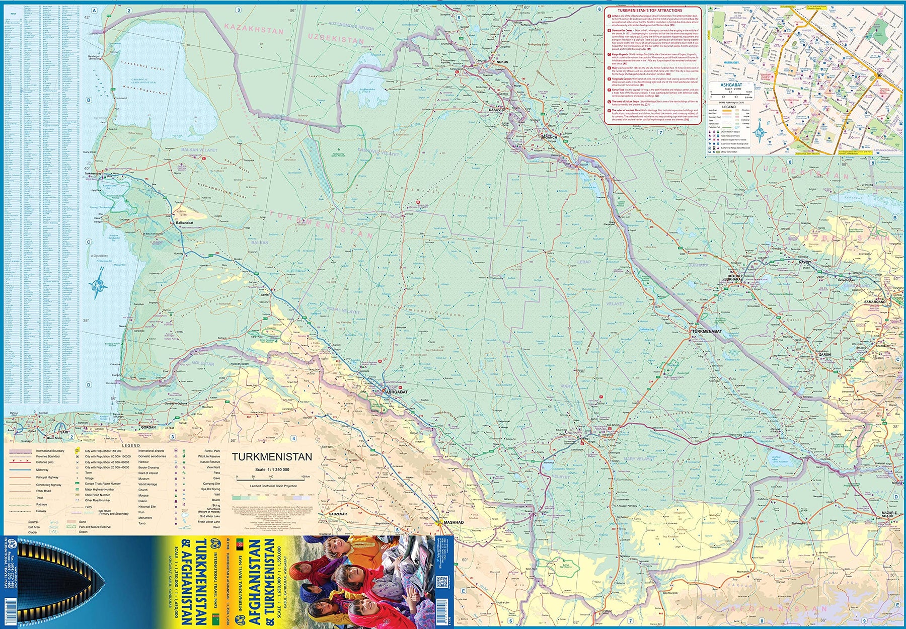
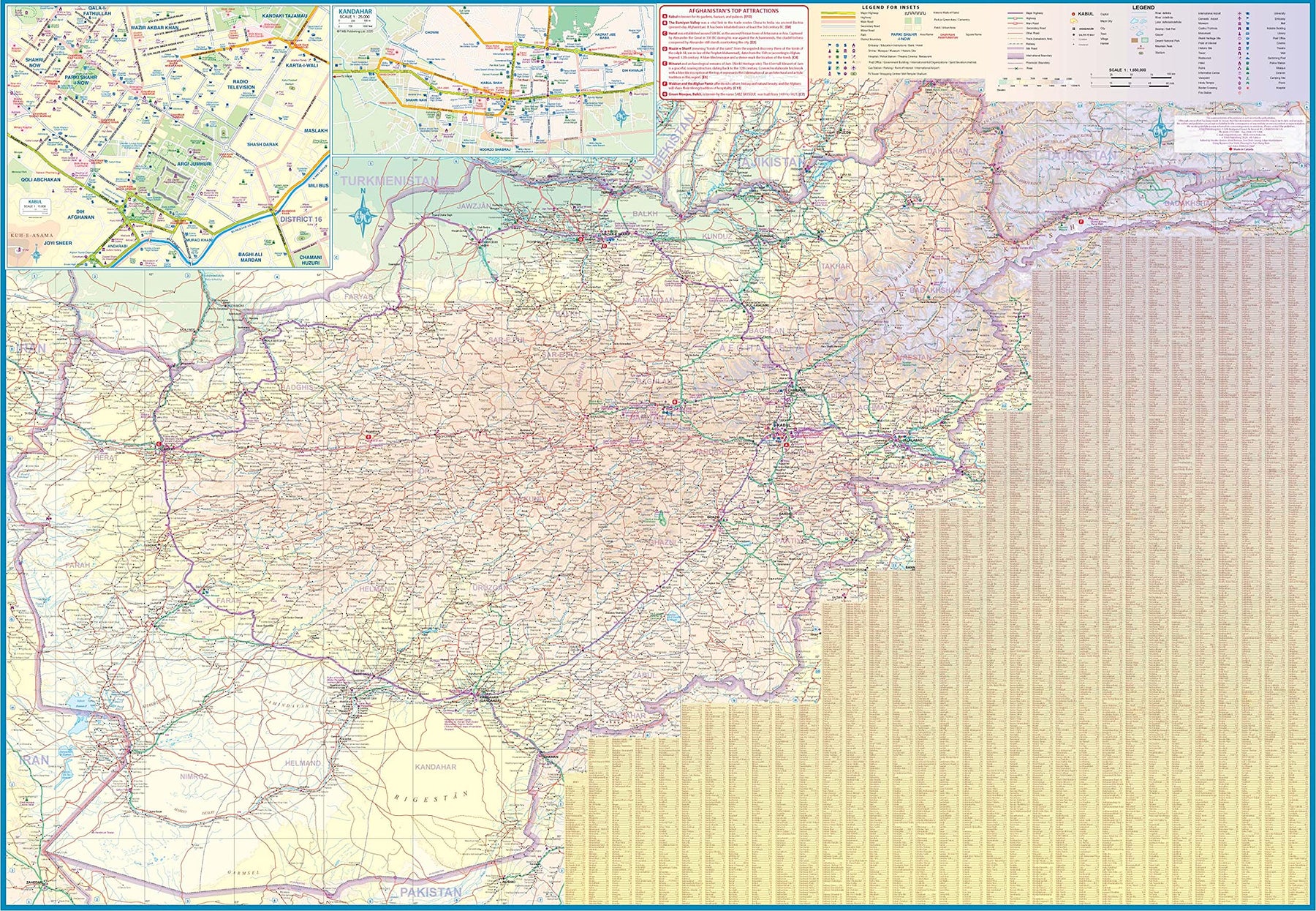
Turkmenistan & Afghanistan
Ordinær pris 179,00 krThe world is changing as a result of a global pandemic, and ITMB has to change with it. We wish to keep all of our artwork available, but at a time of greatly reduced travel, we have been forced to combine two different countries that share a common border in order to justify printing either one. The two countries, Afghanistan and Turkmenistan, do share a common heritage, but a very different history. ITMB Publishes a separate map of the country, and a map of Kabul. The reason for this map is that it is our first ever map of just Turkmenistan, a former part of the USSR that broke away in the collapse of the Russian empire in 1990. The country has, however, not emerged from the Soviet way of thinking, and is authoritarian in its attitude. It is, fortunately, open to travel, and is slowly improving its facilities, so is to be encouraged.
The map includes a very good inset map of Ashgabat, the capital. The country stretches from the Caspian Sea to the Uzbek border and from Russia south to Iran and Afghanistan. We have also added eight Top Attractions, ranging from the World Heritage site of Konye to the ancient ruins of Nisa. We previously published this titles as part of a regional map of the ‘Stans’, but growing demand has justified its own map. We have also published a separate map of Uzbekistan and a separate three-country map of the other three countries, all of which are showing strong signs of touristic development. Turkmenistan is a country emerging as a future travel Mecca. Legend Includes: Roads by classification, Rivers and Lakes, National Park, Airports, Points of Interests, Highways, Main Roads, Zoos, Fishing, and much more...
Uganda
Ordinær pris 199,00 krThe Jewel of Africa, Uganda is a lovely country to visit. Most of the development is in the south, close to Lake Victoria. To me, the most interesting parts are the game parks in the far west and in the far north, but the Mount Elgon area is interesting as well. This updated map also includes a large inset map of Kampala, the capital. The map has been updated to last for the next few years and, by being printed on plastic, is guaranteed to remain durable as well as waterproof.
Ukraine & (Crimea)
Ordinær pris 199,00 krUkraine is the largest country in Europe. Russia doesn’t count because it is mostly in Asia and is generally disliked by everyone. At the moment, Ukraine is holding its own against a concerted attack by Russia to decimate it and make it part of Putin’s Russia. Under normal circumstances, no one should be publishing a map of Ukraine in the middle of a devastating war, but surprisingly, it is one of our best-selling maps for Europe and has gone through three editions over the last three years. The reason is not tourism per se, but information, which is needed by policy makers, aid groups, and armchair followers of developing events. It is also interesting to see an evolving pattern of place name changes as Ukraine gets rid of Russian-imposed names. Bakhmut, location of a famous battle a year ago, is a case in point.
All maps, until now, show the old Russian name; only ITMB’s map shows the new Ukrainian name. With each new edition, we find more names that have changed. So, this map is not important for showing road conditions or power lines because such matters are in the hands of the gods of war. This map is essential for everyone because we are all affected by what happens in Ukraine. ITMB is fortunate in having a cartographer whose passion is Ukraine and is always coming up with yet another place that has changed its name, but nobody noticed. We show the country as it should be, with eastern regions and Crimea being a legitimate part of the country.
United Arab Emirates & Abu Dhabi
Ordinær pris 169,00 krITM har kart over hele verden og de spesialiserer seg på land litt utenfor allfarvei. Beliggenheten til landets nasjonalparker, historiske monumenter, de viktigste veiene og lignende finner du inkludert i kartene. Samtlige landkart har ofte et bykart over hovedstaden.
We are pleased to release this brand new ITMB title. Abu Dhabi is one of the leading Emirates that are rapidly becoming vacation heavens for Europeans who don't want the long flights to Asian destinations. The city is so modern it almost squeaks. The palace is a world-class wonder, the seafront Corniche is a marvelous beach, and the central shopping area offers everything from hamburgers to Gucci bags. Motorways now connect the city state to nearby Dubai and to Oman, with a recently-completed one along the coastline to the Saudi border.
The reverse side of the map is an updated edition of the entire United Arab Emirates and most of Oman, with new motorways seemingly everywhere. A large inset map of central Dubai is included, along with a good one of Muscat. We docked at Abu Dhabi's cruise ship terminal during our visit and were impressed by the extent of urbanization of the city.
United Arab Emirates & Dubai
Ordinær pris 199,00 krITM har kart over hele verden og de spesialiserer seg på land litt utenfor allfarvei. Beliggenheten til landets nasjonalparker, historiske monumenter, de viktigste veiene og lignende finner du inkludert i kartene. Samtlige landkart har ofte et bykart over hovedstaden.
Fra ITM: Dubai is truly becoming a very popular travel destination and the loose federation of sheikdoms collectively known as the United Arab Emirates is growing in popularity with each passing year. Despite the turmoil affecting both Israel and Iran, this part of the Middle East is open for business and peaceful. Side 1 concentrates on the overall region from the eastern border of the UAE to its interaction with Oman. It also has an excellent inset map of Abu Dhabi, the capital of the UAE. Side 2 concentrates on Dubai itself as the largest urban area. Dubai has an extensive and interesting old town on the east bank of the Dubai Creek, which is where most of the hotels and the huge international airport are located. The ‘new town’ is on the left bank, and this is where one finds Western-style shopping areas, high-rise towers, the rapid transit line, and the main motorway out of town. The World Trade Center and Emirates Towers are also centrally located. The man-made Coastal Projects are shown in insets.
United Arab Emirates & Gulf Cruising
Ordinær pris 169,00 krITM har kart over hele verden og de spesialiserer seg på land litt utenfor allfarvei. Beliggenheten til landets nasjonalparker, historiske monumenter, de viktigste veiene og lignende finner du inkludert i kartene. Samtlige landkart har ofte et bykart over hovedstaden.
From ITMB: The Gulf, in this case, is the Persian Gulf, or if you prefer, the Arabian Gulf or, if you wish to, the Iranian Gulf. Regardless of which name one prefers, it is the body of water between Iran and the Arabic Emirates of Bahrain, Qatar, Dubai, and Oman/Muscat. It is also a popular cruising locale, with ships operating from Dubai to various ports of call. It also covers a considerable amount of geography, so side 1 concentrates on the water area from Kuwait/Iraq/Iran south to Bahrain and Qatar, along the coastline of the UAE to Oman and the Straits of Hormus, and along the coast of Oman to Muscat. It also includes inset maps of Manama (Bahrain), and Doha (Qatar), for the convenience of users. The second side of the map shows all of the United Arab Emirates and most of Oman, with insets of central Dubai and Muscat. Each side includes a listing of the top attractions of the side being shown. This is the third of ITMB’s growing range of cruising maps. We believe that the future of travel includes cruises as a popular means of exploring exotic travel destinations while retaining a comfortable environment. My wife and I cruised the Gulf a couple of years ago and found cruising to be an excellent way to explore several different countries that would be difficult to reach in any other manner. One day, I hope that cruises in this part of the world will extend to ports of call in Kuwait, Iraq, and Iran.
USA/Canada: Alaska's Inside Passage & British Columbia Coast
Ordinær pris 199,00 krThis is a new map for us, combining both the Canadian and the American portions of the Pacific coastline north from the Seattle area to the Alaska Panhandle, ending at the Glacier Bay National Park, which extends considerably north of the Bay itself. Side one concentrates on the Canadian portion, from Victoria north to the Queen Charlotte/Haida Gwaii islands, showing ferry routes and the routes most favoured by cruise ships. As a coastal map, it doesnt go very far inland, but shows the Coastal mountain range to good advantage.
Side two provides a very detailed map of that portion of Alaska known as the Panhandle a series of islands north and west of Canada that is very popular with cruisers. All parks and cruise line routes are shown. Interestingly, at the top end of Glacier Bay, the Canadian border splits the Panhandle from the rest of Alaska; not intentionally, but when the border was agreed upon in the early 1900s, no one realized that the glacier on that site might one day melt. Well, melt it has, leaving a kilometre-long stretch of beach that is part of Canada! Regardless, this map completes ITMB mapping of the Pacific coastline of North America rom the Bering Sea to Panama, a cartographic task that began decades ago.
USA: Alaska
Ordinær pris 169,00 krITM har kart over hele verden og de spesialiserer seg på land litt utenfor allfarvei. Beliggenheten til landets nasjonalparker, historiske monumenter, de viktigste veiene o.L. Finner du inkludert i kartene. Samtlige landkart har ofte et bykart over hovedstaden.
Fra ITM: The State of Alaska is a perennial best-seller. The area is emerging from Covid and tourism is returning. Now is the appropriate time to stock up for those planning a visit in the spring and summer months. Cruises will start operating again in May, and this is the most popular way to reach Alaska from Seattle or Vancouver, while enjoying ports of call along the way. If you do a cruise, make sure that you note the glacier at the northern end of Glacier Bay, which all ships visit. It has retreated to the point where a land mass is visible. That’s Canada. The border was set when the Icefield extended quite a ways further south, and no one realized at that time that there was no land under the ice. Technically, Alaska is now two parts – the peninsula and the mainland! Don’t tell the Americans!
USA: Appalachian Trail
Ordinær pris 199,00 krThis is a new venture for ITMB, although we have published several recreational hiking maps over the years. The Appalachian mountain range was the original western boundary of the American colonies while under British rule. Everything west of there was technically the French possession of Louisiana Territory, called by American settlers ‘Indian country’. Nowadays, it is a massive recreational hinterland for east coast residents wanting to escape overcrowded cities. The National Parks Service maintains the trail and a series of overnight huts.
Most people only hike a portion of the trail, but for the dedicated hiker, the trail is a great adventure. We have divided the length of the trail into four natural regions: Maine into New York State, Connecticut south to Maryland, Maryland to Virginia, and Virginia to Georgia, to its traditional end at Springer Mountain. This is a demanding trail hike, but one of the most popular in the world.
USA: Arizona & New Mexico
Ordinær pris 169,00 krThis version includes two separate covers, one for each state, to enhance marketing possibilities, and the addition of two Top Attractions listings, one for each state. The Arizona side has a detailed inset map of Flagstaff, showing the path of Route 66 through the city streets. The New Mexico side includes a large inset of Albuquerque, also including the Route 66 passageway through the city.
USA: California
Ordinær pris 199,00 krThe American State of California has almost as many residents as all of Canada. I wonder how many of them are ex-pat Canucks? Regardless, this double-sided map shows the attractions of the state in amazing detail. Side 1 concentrates on the northern half, with a large inset map of San Francisco. A fairly large portion of Nevada shows as well, but with less detail.
Side 2 continues south to the Mexican border and east to Arizona, with a detailed inset map of central Los Angeles included. By the shape of California, all of southern Nevada is included as well, including the all-important wasteland of Las Vegas. All motorways are clearly shown, including those in greater Los Angeles. All state highways are also shown, as well as most secondary connecting roads. Parks, points of interest, beaches, redwood forests, and distances between major communities are also shown. The state is blessed with interesting offshore islands, such as Catalina, San Clemente, and the Channel Islands, all of which are included.
USA: Chicago & Illinois
Ordinær pris 199,00 krITM har kart over hele verden og de spesialiserer seg på land litt utenfor allfarvei. Beliggenheten til landets nasjonalparker, historiske monumenter, de viktigste veiene og lignende finner du inkludert i kartene. Samtlige landkart har ofte et bykart over hovedstaden.
Fra ITM: Chicago is one of the largest cities in the USA and has long been famous for its rail hub joining lines from the east coast to those serving the western regions. It is also the start (or the finish) of famed Route 66, the first paved highway to the Pacific. Side 1 covers the city from the convention centre north to Wrigleyville and from the lakefront west to Western Avenue, with a large inset of Greater Chicago and another of Oak Park (famous for being the home of Frank Lloyd Wright). Side 2 is a brand new map for ITMB, being of the great state of Illinois, of which Chicago is a small part. This side traces Route 66 southwest from its origins in downtown Chicago to somewhat beyond St. Louis, where the national highway continues into Missouri. This map starts on Wisconsin in the north, at Minneapolis, and continues south to western Kentucky, ending at Nashville, Tennessee and is loaded with touristic attractions that are sure to delight visitors.
Publisert: 2025
Innbinding: falset
Material: vanntettpapir
Målestokk: 1:12,000/1:1,000,000
USA: Grand Canyon & Arizona
Ordinær pris 169,00 krArizona is an amazingly attractive State to visit, with Route 66 attractions in the north, bustling Phoenix in the centre, and a strongly-influenced Mexican influence in the south. Thus, a travel map for the state makes sense, and this one shows camping sites, local attractions (including Tombstone) and includes inset maps for Flagstaff and Grand Canyon Village. Its main attraction, however, is Grand Canyon, a deep defile carved out over millennia by the Colorado River, on its way to the Gulf of Mexico. This is one of nature's wonders, and a "must see" for everyone.
This results in a very interesting and useful map, covering both one of the most interesting States in America AND one of the great natural phenomena of the world. The map is printed on waterproof and biodegradable stone paper, which is a technological marvel in its own right, in this case for durability rather than to protect against moisture.
USA: Hawaii - Maui; Kauai & Molokai
Ordinær pris 199,00 krThe island of Maui may not be at well-known as Oahu, which is extremely popular with Japanese honeymooners, but it is as attractive touristically. Our coverage covers most of Side 1 and includes a detailed inset map of Wailuku, the principal urban area, as well as insets of Lahaina on the west coast and Wailea resort area. This side also includes a map of the island of Lanai, with its main urban area of Lanai City as an inset.
Side 2 concentrates on the islands of Molokai, Kauai, and the lightly populated island of Ni’ihau, and includes detailed inset maps of Lihue, Kaunakakai, and Po’ipu, all of which are major resort destinations. The islands are loaded with beaches and places to stay, but also with attractions, which are shown on the map. This is a beautiful map, one of the best we have ever produced, and is a fitting companion to our maps of Big Island, and Oahu/Honolulu, as well as our state map. The Maui/Kauai map also has a double-sided cover, so can be displayed as two separate maps.
USA: Hawaii Volcanoes National Park & Big Island
Ordinær pris 199,00 krWe didn't suspect, when we started developing this title, that Mauna Loa Volcano would erupt as soon as our map of the national park was printed, but it did! It is on the news every night, and a marvelous touristic attraction. How many of us can ever see a massive eruption of molten lava? Now, we can! (at least, from a safe distance). The national park occupies one side of the map and is the latest in ITMB's series of national parks. By the nature of such parks, we show all the features and elevations, but in this case, we'll add the proviso that heights and lava flows are changing the landscape on a daily basis. Volcanoes are sort of like elephants-they go where they please!
The reverse side of the sheet is a map of Big Island, where the park is located. Its name comes from being the largest island in area of all the Hawaiian archipelago. The map includes an inset of Hilo, the largest city on the island, located on a calm bay of the east coast, and a separate inset of Kailua-Kona on the west coast, which is also the focal point for surfing and resorts. This pretty much completes our detailed mapping of Hawaii; in addition to this title, we have maps of the complete state and of each major island, as well as a new map of Honolulu/Waikiki. The map is printed on waterproof stone paper, which could prove very useful in tropical Hawaii!
USA: Honolulu & Oahu
Ordinær pris 199,00 krHonolulu/Waikiki is a brand new map for ITMB, and our first new title for a part of the USA this year. Almost everyone flying to Hawaii goes to Honolulu, and the vast majority stay in hotels located close to Waikiki Beach. This is quite a comprehensive city plan map for the Honolulu urban area, stretching from east of Diamond Head to the international airport. It also includes a large inset of the Pearl Harbour area, with its many memorials to the ships sunk during the surprise Japanese attack on December 6, 1941. Ford Island is still a major US military base. Our Top Attractions list shows the highlights of touristic interest.
The second side is a newly-updated version of our map of the island of Oahu. Although the focus of this map is on Honolulu, most visitors include day trips to outlying areas of the island. There are numerous coves where one can enjoy a reasonably isolated experience, and attractions such as the Dole Pineapple Farm to enjoy. It is not possible to drive all the way along the coast. Waimea Bay offers the best "big wave" surfing. A very popular activity is to climb to the rim of Diamond Head volcano.
USA: Las Vegas & Region
Ordinær pris 199,00 krStreet plan of Las Vegas with a map of the Las Vegas region at on the reverse. Street names are clearly marked, with rail and monorail lines and stations displayed. Places of interest are shown, with the names of casinos, wedding chapels, shows such as Spamalot all displayed prominently. Local facilities such as petrol stations, hotels, swimming pools are marked.
USA: Miami & Southern Florida
Ordinær pris 199,00 krITM har kart over hele verden og de spesialiserer seg på land litt utenfor allfarvei. Beliggenheten til landets nasjonalparker, historiske monumenter, de viktigste veiene o.L. Finner du inkludert i kartene. Samtlige landkart har ofte et bykart over hovedstaden.
Fra ITM: Miami is one of America’s most vibrant cities, thanks to its large Cuban population. Historic Miami Beach is, of course, famous and loaded with art-deco beach hotels. The second side of the map encompasses a detailed map of Florida from the Keys north to Daytona Beach, including such well-known destinations as Tampa, the Everglades, Fort Lauderdale, Cape Canaveral, and Disneyland.
Publisert år: 2025
Innbinding: falset
Material: vanntettpapir
Målestokk: 1:12,000/1:600,000
USA: Nevada & California North
Ordinær pris 169,00 krITM har kart over hele verden og de spesialiserer seg på land litt utenfor allfarvei. Beliggenheten til landets nasjonalparker, historiske monumenter, de viktigste veiene og lignende finner du inkludert i kartene. Samtlige landkart har ofte et bykart over hovedstaden.
Fra ITM: The USA is one of the most challenging countries to map due to its strong identification with state boundaries. Last month, we introduced two new maps of Idaho and Montana; this month, we wish to introduce Nevada. As a state, Nevada is mostly desert-like and is lightly populated. Its two major urban areas, Las Vegas and Reno, are extremely popular travel destinations. In addition, Nevada offers the Hoover Dam, one of the seven wonders of the modern world, a national park with 5,000-year-old pine trees, America’s second deepest lake (Tahoe), the eighth highest mountain peak in the USA, and the biggest air force bombing range in the world (Nellis). The map is double-sided, and covers northern California on the other side. This includes such treasures as Death Valley, part of the Mojave Desert, Yosemite National Park, the beautiful sequoia trees in the far northeast corner, and man-made wonders such as the Golden Gate Bridge and Highway 1 along the Big Sur coastline. Nevada is a valuable addition to ITMB’s growing line of State maps; after all, it’s about the size of France!
Publisert år: 2021
Innbinding: falset
Material: vanntettpapir
Målestokk: 1:875,000
USA: Northeast
Ordinær pris 199,00 krITM har kart over hele verden og de spesialiserer seg på land litt utenfor allfarvei. Beliggenheten til landets nasjonalparker, historiske monumenter, de viktigste veiene o.l. finner du inkludert i kartene. Samtlige landkart har ofte et bykart over hovedstaden.
Fra ITM: The original British colonies that prospered were the ones closest to England. Makes sense! Rhode Island, Massachusetts, Connecticut, and New York were relatively closer to London than Virginia and the Carolinas, so they got the benefits of the Industrial Revolution first. This part of the USA is riddled with historic sites, as well as large urban areas, such as Boston and NYC. Its charm as a regional map is that it combines like-minded areas together on one sheet at a scale that is manageable and easy to read. There are countless parks to explore, such as Campobello, which is actually in Canada, but most easily accessed from Maine. The Cape Cod peninsula is one of the most visited sites in the USA, with colonial-era Provincetown at its tip. There are many motorways and highways that allow easy travel, as well as rapid train services along the coast to NYC and Washington. Side 2 concentrates on the rest of New York State and shows a fair portion of Pennsylvania. Although the Canadian border areas are shown, along with crossings, relatively little of the countryside north of the USA is shown in order to concentrate one’s efforts on exploring the historic heart of America.
USA: Orlando & Southern Florida
Ordinær pris 189,00 krITM har kart over hele verden og de spesialiserer seg på land litt utenfor allfarvei. Beliggenheten til landets nasjonalparker, historiske monumenter, de viktigste veiene o.L. Finner du inkludert i kartene. Samtlige landkart har ofte et bykart over hovedstaden.
Fra ITM: Florida is one of the most travelled-to parts of the world, and with Orlando in its centre, a map is necessary as well as inevitable. The big attraction, of course, is the Walt Disney World resort area, which is yet another must-see destination. The resort is so large that it requires its own inset map and has eighteen hotels at last count, its own monorail, and too many attractions to note here. Disneyland is for everyone young and old, so enjoy it.
Publisert år: 2024
Innbinding: falset
Material: papir
Målestokk: 1:10,000/1: 600,000
USA: Pacific Coast
Ordinær pris 199,00 krOur west coast map, covering from Vancouver down to Tijuana has proven to be one of the most popular maps published by ITMB. This edition closely resembles previous ones, in that it focuses on the road network from north to south, covering all of Washington State, Oregon, and California on one double-sided sheet, showing all passenger-service railway lines as well. By the shape of the area covered, the western portion of Nevada is also shown as well. Space limitations did not enable us to include insets, so travellers should be advised to obtain ITMB city maps of Seattle, Portland, San Francisco, Los Angeles, and San Diego to supplement this map with more detailed coverage. This map also includes Yosemite National Park, for which ITMB also provides a separate detailed map. Hundreds of wilderness campgrounds are also included.
USA: Philadelphia & Pennsylvania
Ordinær pris 169,00 krITM har kart over hele verden og de spesialiserer seg på land litt utenfor allfarvei. Beliggenheten til landets nasjonalparker, historiske monumenter, de viktigste veiene og lignende finner du inkludert i kartene. Samtlige landkart har ofte et bykart over hovedstaden.
Fra ITM: Historic Philadelphia is one of the most significant travel destinations in the USA. Founded as a Quaker town for dissidents from England, it evolved into being the unofficial capital of the 17 American colonies by 1770. In the preamble to the American independence movement, it was a crucial ingredient in negotiations designed to address grievances. The British organized a meeting that has since become known as the Congressional Congress of 1775, in what is now known as Independence Hall. All seventeen American colonies sent representative delegations to debate the future. Phillie today is a modern city with a specially-designated historic centre, and all the important sites are noted on this map.
The other side of the sheet is a brand new map, continuing ITMB’s drive to create state maps wherever practical. This one is of Pennsylvania, a lovely and scenic part of America, stretching from the Atlantic seaboard to Lake Erie and the border with Ohio. New York City/Long Island and much of southern New York State is included, as are portions of Maryland, and Virginia. Delaware, due to its size, is completely included. All motorways and highways are noted, as well as recreational and historic locations; most notably, the tragic crash site of Flight 93 east of Pittsburgh.
The State of Pennsylvania has a long and valued history and we are pleased to add it to our range of American titles. Legend Includes: Roads by classification, Rivers and Lakes, National Park, Airports, Points of Interests, Highways, Main Roads, Zoos, Fishing, and much more.
USA: San Diego & California South
Ordinær pris 169,00 krITM har kart over hele verden og de spesialiserer seg på land litt utenfor allfarvei. Beliggenheten til landets nasjonalparker, historiske monumenter, de viktigste veiene o.L. Finner du inkludert i kartene. Samtlige landkart har ofte et bykart over hovedstaden.
Fra ITM: In the southwest corner of the American mainland is the port city of San Diego, one of the major hubs of the US Navy. The city itself is very interesting, with a city centre dominated by colonial-styled buildings. Balboa Park is home to one of the best zoos in North America, and the historic 'old town' area north of the city centre has become a popular 'Old Mexico' theme attraction. As well, there is the Tijuana Trolley, which is, in fact, a modern surface-rail tram line that goes from the city centre to close to the walk-across border with Mexico into colourful downtown Tijuana. A day visit to Mexico is one of the highlights of a visit to San Diego! Enjoy!
Publisert år: 2023
Innbinding: falset
Material: papir
Målestokk: 1:15,000 / 1:900,000