77 produkter
77 produkter


77 produkter
Norway: North & Central
Ordinær pris 169,00 krNorway is one of the more interesting countries in Europe for travellers, in that it has wide open spaces and unusual Arctic scenery, particularly in the north. Because it is a rather long and narrow country, trying to portray it adequately on a single sheet results in a lack of scale adequate for showing touristic attractions. This map covers the northern portion of the country, from Trondheim to Nordkapp and from the North Atlantic to the Russian border. It also shows a portion of northern Sweden and a bit of Finland and Russia, but its focus is on roads, rail connections, airports, distance markers, parks, and touristic attractions in the region. Most noticeably, the rail lines leading to Trondheim and north to Bodo are clearly shown. Communities, sometimes fairly small, are included, as are ferries to outlying islands close to the coast.
The reverse side shows the rail line to Narvik coming in from Sweden, and all roads and towns north to the Arctic Ocean and east to the Russian border. Border crossing to Sweden/Finland are not shown, as both countries are part of the EU, but crossings to Russia are shown, albeit closed at the moment.
Norway: Oslo, Bergen & South
Ordinær pris 199,00 krThis map represents a major step forward on coverage of southern Norway. The map is now on tear-resistant stone paper and places Oslo and Bergen on one side, allowing us to include a large-scale map of all of southern Norway as far north as Trondheim on the other side. This covers the portion of Norway most visited and includes all the best-known fiords. The back cover also shows a schematic rendition of the 6 metro lines in Oslo, plus the tram network and the commuter rail from the airport into the city.
Norway: Spitsbergen & Svalbard & Northern Norway
Ordinær pris 199,00 krPoland: Krakow & South Poland
Ordinær pris 199,00 krThe Polish city of Krakow is medieval in its city centre, with its walled fortress, the Wawel (a world heritage site) and its old town, which is now largely a pedestrian precinct. The Rynek Glowny, or central square, is the largest in Europe and features the 16th century Cloth Hall and the 14th century cathedral. Nearby is the Wieliczke Salt Mine, another World heritage site, and a wonder to explore. Also nearby is Tyniec Abbey, dating back to the 11th century.
The reverse side covers southern Poland, from Warsaw in the north to the Carpathian Mountains. Poland is one of Europes hidden treasures, with small villages and ancient towns, such as Zamosc (another world heritage site), national parks, chalk tunnels (in Chelm) a martyrs clock (in Lublin), and a bishops palace (in Kielce). Put them all together, and a marvellous travel experience unfolds!
Poland: Warsaw & East
Ordinær pris 149,00 krITM har kart over hele verden og de spesialiserer seg på land litt utenfor allfarvei. Beliggenheten til landets nasjonalparker, historiske monumenter, de viktigste veiene o.L. Finner du inkludert i kartene. Samtlige landkart har ofte et bykart over hovedstaden.
Fra ITM: This is, at the same time, our second edition updated map of Warsaw and a brand new title for ITMB, in that we have added a regional map of the eastern half of Poland to the second side of the map. This gives the end user two maps for the price of one by combining the many attractions of the city with its surrounding countryside. Anyone with a small amount of historical knowledge knows that Warsaw was largely destroyed during World War II. Many historic cities suffered this fate; in the case of Warsaw, the historic old town was re-built more or less as it had been, with some road widenings changing things, and the rest of the city was re-created as a post-war urban area. The old town is actually quite compact, so is shown in detail on an inset map, as is the greater Warsaw urban area The urban map shows rail and metro lines/stations, tram lines, churches, theatres, the enormous Soviet-era cultural centre, hotels etc. The regional map covers a very large portion of eastern Poland, from the eastern borders to Lodz, and includes the roads leading to Krakow and Gdansk; altogether, a perfect map for those using Warsaw as a base and exploring the hinterland on short trips.
Publisert år: 2018
Innbinding: falset
Material: papir
Målestokk: 1:10000
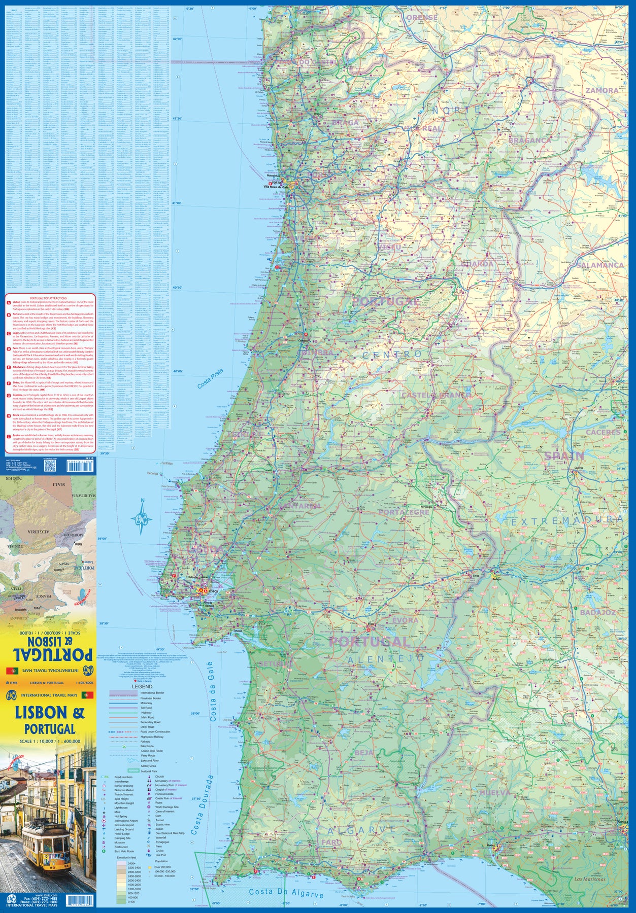
Portugal
Ordinær pris 199,00 krITM har kart over hele verden og de spesialiserer seg på land litt utenfor allfarvei. Beliggenheten til landets nasjonalparker, historiske monumenter, de viktigste veiene o.L. Finner du inkludert i kartene. Samtlige landkart har ofte et bykart over hovedstaden.
Fra ITM: We are very pleased to be able to release a double-sided detailed map of Portugal. Although we have included the country in previous maps, it was always as an adjunct to another map (Spain and Portugal, Portugal and Southern Spain etc.), so it is high time that this very nice popular country had its own ITM map. Being a long, rather thin country, Side 1 concentrates on Lisbon and the southern half of Portugal with a detailed inset map of Lisbon. It also includes the Spanish provinces of Huelva and Badajoz. Side 2 covers the northern half of the country along with portions of neighbouring Spanish provinces. As a country, Portugal has a wealth of touristic attractions and we have included as many as we can on this map without cluttering it – castles, palaces, fortresses, cathedrals and churches, dozens of museums, beaches, a few hotels, mines, monuments, and just about everything a visitor would want to have. Of course, motorways, highways, secondary routes, rail lines, ferry services, and geographic heights of land are also included; altogether, a fabulous map for a wonderful country.
Publisert år: 2025
Innbinding: falset
Material: Papir
Målestokk: 1:500,000
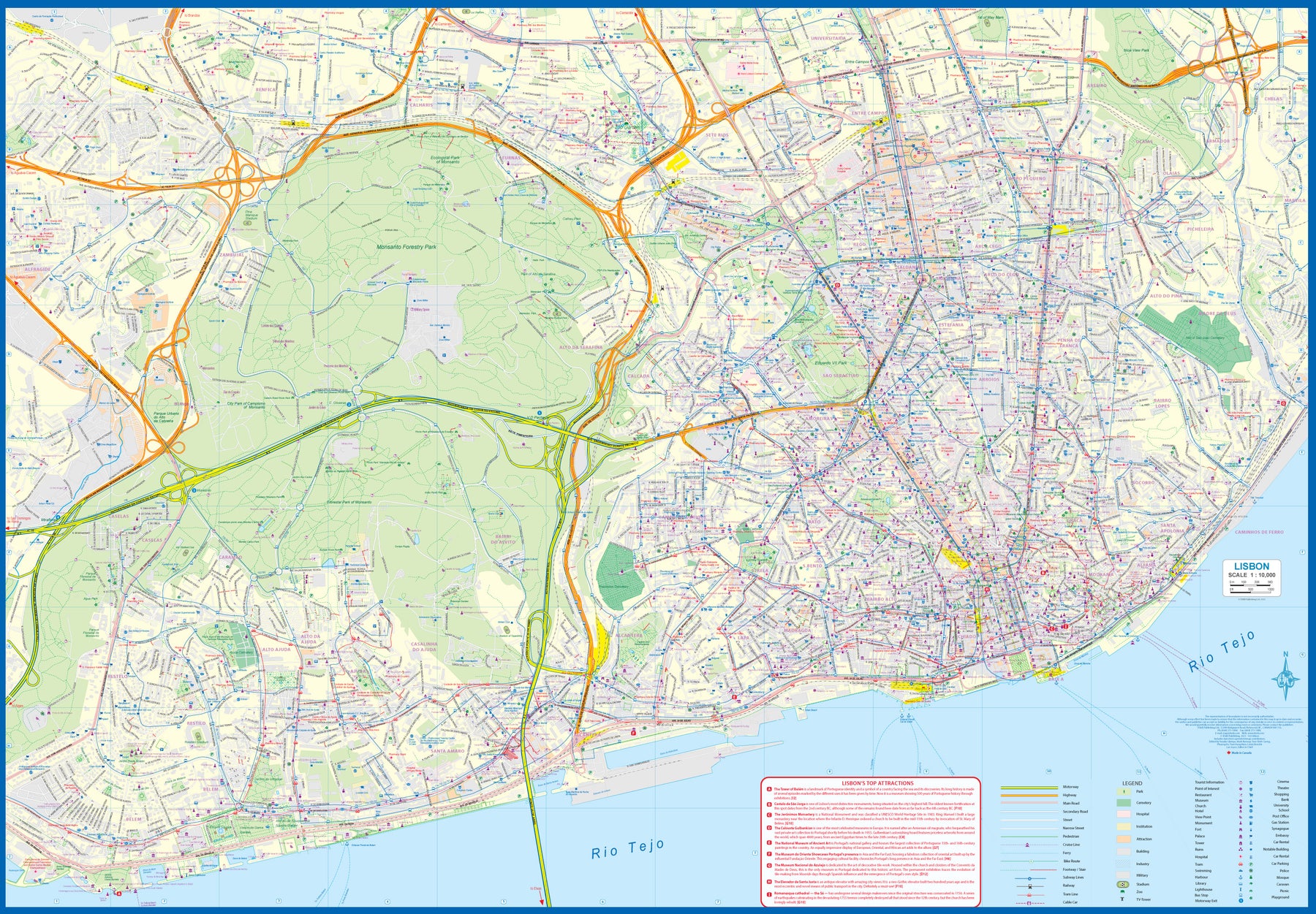
Portugal: Lisbon & Portugal
Ordinær pris 199,00 krThe city of Lisbon is one of the most attractive in Europe. It is an ancient city, but most of its architecture dates from the Victorian era. It has a fascinating number of tram lines, and the trams tend to be an experience worth the trip. One graces our cover. There is no cheaper way to explore this city than to climb aboard and let the rails decide your destination!
Coverage extends from the northern and western motorways to the southerly Rio Tejo and the national museum, so shows the city quite comprehensively. Almost half of the map area is of the massive Monsanto Park, one of the largest urban parks in the world. The reverse side is equally important, in that it presents our first-ever map dedicated to showing the charms of the entire country of Portugal. A bit of western Spain is included due to the unevenness of the border, but the map goes from the northernmost tipoff Castelo to the southernmost expanse of the Costa Do Algarve, showing touristic attractions, historic sites, beaches, museums, rail connections, and major parks.
The map is printed on waterproof stone paper, a recent technological innovation that is gradually replacing plastic.
Rhine River Cruising
Ordinær pris 199,00 krThe Rhine River flows from the Gletch Glacier in the Swiss Alps north to central Germany and then on to Amsterdam and the North Sea. It has been a major transportation link in Europe for many centuries, with dozens of castles located at strategic points. Today, it is a peaceful touristic haven as well as a busy working river, with dozens of shallow-draft boats wending their way around countless turns in the river. It is probably the busiest tourist highway in Europe. This double-sided map starts in Amsterdam, where it is known as the Waal, and follows the course of the river inland past Nijmegen to the German border, where the name changes to Rhine. There are many notable interesting cities along its route, such as Essen in the Ruhr Valley, Dusseldorf, Koln, with its magnificent cathedral, Bonn, Castle Arenfels, Koblenz, and Rüdesheim, where it joins the Main River and heads east to Frankfurt-on-Main and points east. As a map is a rectangular sheet of paper and a river is a narrow portion wending its way as geography takes it. This is much more than a simple river map. It is a detailed portrayal of a very interesting part of Europe, extending far beyond the banks of the river, and is ideal for those travelling by car, by train, or by river boat. A detailed city centre map of Frankfurt is included.
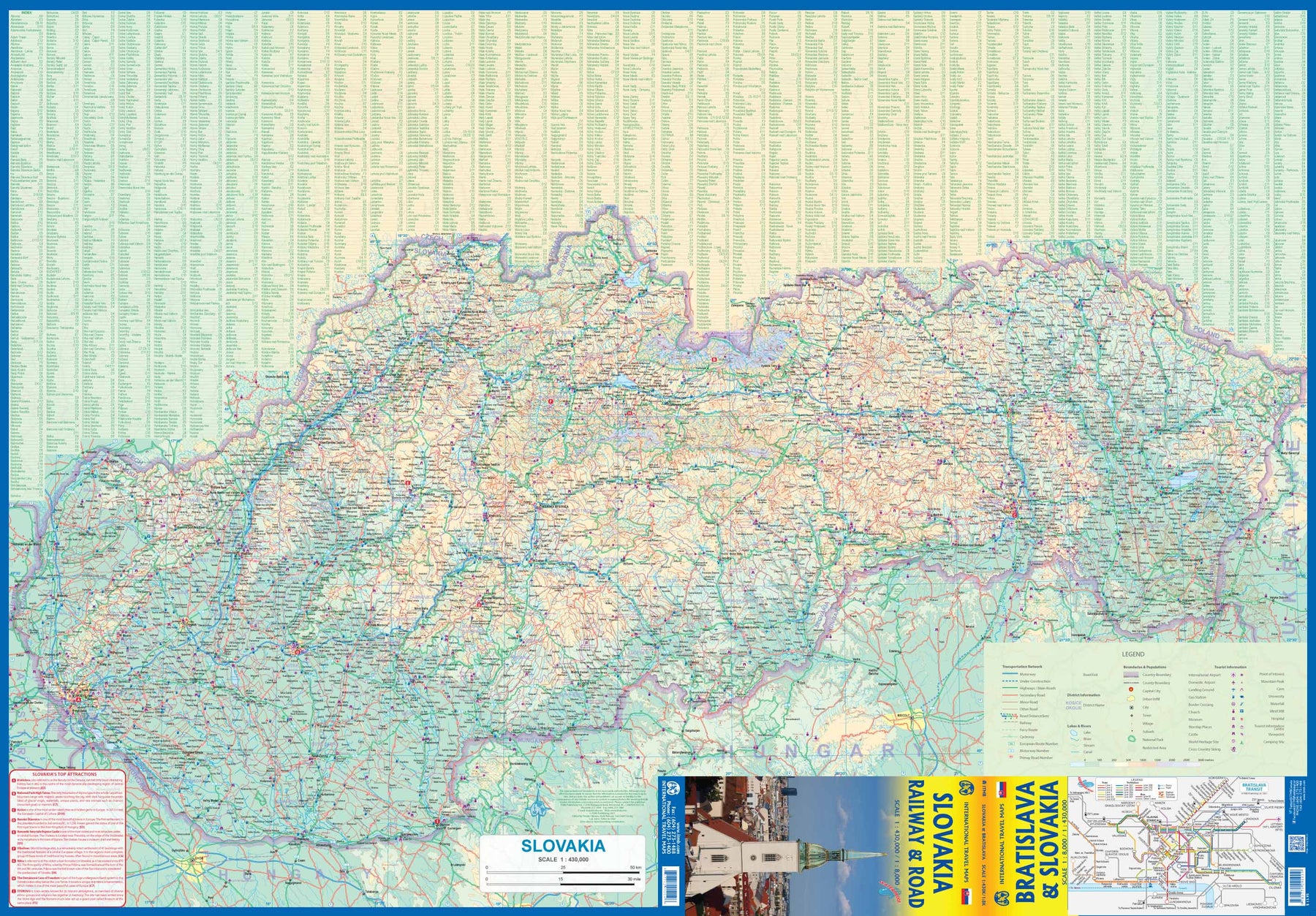
Slovakia - Railway & Road
Ordinær pris 169,00 krAs tourism to the eastern reaches of Europe becomes more popular, Slovakia is well-positioned to present an attractive opportunity for exploration. ITMB previously included this country with adjacent Hungary, but now we have expanded coverage and included a detailed map of Bratislava (1:8.000). Side 1 (1:430.000) shows the elongated country from its Austrian and Czech borders to its increasingly important border with Ukraine. As usual, we have included a listing of Top Attractions, such as the little-known towns of Kosice, Banska Stiavnica, and Sturovo, as well as the karst underground caves of Demanova and the fairy tale castle of Bojnice.
Side 2 portrays the capital city of Bratislava in excellent detail, showing the Danube River and the old town in great detail, along with the newer outlying areas of Petrzalka and Ruzinov. The map is printed on waterproof stone paper for durability. Legend Includes: Roads by classification, Rivers and Lakes, National Park, Airports, Points of Interests, Highways, Main Roads, Zoos, Fishing, and much more...
Spain
Ordinær pris 199,00 krSpain is an ancient land full of historic sites dating from Roman times or the Moorish occupation. As a country, it divides naturally into northeastern Catalonia, northwestern Galicia, Central Toledo, and the Mediterranean coastal regions. This map is double-sided, with the portion closer to Portugal on one side and the Mediterranean coast from the French border to Granada on the other side. Spain has invested heavily in road improvements since joining the EU and has enthusiastically embraced rail line improvements in line with the EU’s efforts to wean travellers away from automobiles. This map emphasizes the railway network. The map also includes inset maps for the Canary Islands and the Balearics in the Mediterranean.
Spain: Balearics - Mallorca; Ibiza & Menorca
Ordinær pris 199,00 krThe Balearic Islands in the western Mediterranean have been extremely popular travel destinations for centuries. Mallorca/Majorca and Ibiza have become favoured visits by cruise ships to these islands in recent years, but the warm climate has attracted visitors for a long time. Side 1 concentrates on the three major islands of Mallorca, Ibiza, and Menorca but includes the smaller islands of Formentera and Cabrera, along with an inset map showing the islands in relation to the Spanish mainland ports of Valencia and Barcelona. Side 2 focusses on cruising the entire western half of the Mediterranean, from Naples west to Gibraltar. Naturally, the Balearics end up right in the centre of the map, which also includes the islands of Corsica and Sardinia, both of which are becoming increasingly popular with those cruising. I hasten to add that cruising is the fastest growing segment of the entire travel industry, so is an important market for the mapping industry.
Spain: Mediterranean Coast
Ordinær pris 199,00 krSpain is one of the most popular travel destinations in Europe. The country is extremely diverse, reflecting its history. The coastal areas of the Mediterranean were probably first settled by Phoenicians, then Greeks, then Romans, and then Arabs before being brought into a united Spain at the time Columbus was seeking a sponsor to fund his proposed journey to discover new lands to the west. This map focuses on the coast from the French border south through Catalunya all the way to the Straits of Gibraltar and Cadiz. The offshore islands of Mallorca, Ibiza, and Menorca are included, as is the North African Spanish enclave of Ceuta and the British enclave of Gibraltar.
All road and rail lines are shown, including the new Cadiz to Madrid fast train. By the nature of mapping, a considerable amount of the interior is on the map as well, so this map is much more than just a coastal journey through Valencia and Murcia to reach Granada, although that would be a very enjoyable trip. The map is equally applicable to interior trips to Cordoba or Albacete as it is a map of the coast. However, its purpose is to show the attractions of the coast – beaches, resort areas, historic towns, forts, nature reserves, archaeological remains, and Top Attractions.
Zurich & Northern Switzerland
Ordinær pris 199,00 krCity map Zurich and Road map Northern Switzerland.
Switzerland is a lovely country to visit, albeit rather expensive, and is conveniently located in the heart of western Europe. Zurich, as a city, is not only commercially important but is a lovely city to visit and enjoy. The Old Town is a walking paradise, with stores intermingled with squares and churches, and the hilly nature of the city brings photographic images to the forefront with each turn of a corner. ITMB publishes a separate map of Geneva on one side and all of Switzerland on the other side.
For this title, we have expanded the scale and filled the reverse side with and easy-to-use regional map of North-western Switzerland, combining the city with its hinterland. Being a rather small country, this results in a map covering most of the country, from Lausanne in the southwest and Basle on the north to Chur on the east and Montreux in the south, so the far east and south of the country are excluded.