317 produkter
317 produkter


317 produkter
Tanzania
Ordinær pris 199,00 krAfrica generally has been slower to recover economically from the Covid era, but is just as fascinating as ever. ITMB is finding that many of our maps of countries in Africa are approaching the end of their print runs and will see new editions through the rest of 2024 and into 2025. Tanzania is one of the first to be updated and refreshed. Printed on waterproof stone paper, Side 1 concentrates on the southern half of the country, from Dar es Salaam (the actual capital) south to the borders with Mozambique, Malawi, and Zambia. This is game preserve country, with Selous taking pride of place.
Side 2 concentrates on the northern portions, which are more popular. Game preserves such as Serengeti and Ngorongoro compete with Mount Kilimanjaro and Lake Victoria for attention. The islands of Pemba and Zanzibar are easy to reach from Dar. A large portion of Kenya is shown, as well as significant portions of Burundi and Rwanda. Detailed inset maps of Arusha and Stone Town are also included, as are all seven border crossings into Kenya. Tanzania is a very large country geographically, so visitors really need a map to get around.
The World
Ordinær pris 199,00 krITM har kart over hele verden og de spesialiserer seg på land litt utenfor allfarvei. Beliggenheten til landets nasjonalparker, historiske monumenter, de viktigste veiene o.L. Finner du inkludert i kartene. Samtlige landkart har ofte et bykart over hovedstaden.
Fra ITM: As a worldwide mapping firm, ITMB has, of course, published wall maps of the world, but until now, we have not been able to offer a convenient folded version of the world. This map portrays the world politically, with large countries showing provincial/state boundaries, as well as a good selection of cities. A map of the world involves a certain amount of political juggling in order to be acceptably accurate while noting areas of political sensitivity Thus, Ukraine is shown with its traditionally accepted borders, despite Russia’s incursions, Gaza is far too small to show, but we do name Palestine. Taiwan is in a different colour than mainland China, Western Sahara is noted by colour but not named as it doesn’t exist except in the fevered imaginations of certain countries, and the Gulf of Mexico has its normally-accepted name. Antarctica, unfortunately, does not show well. Basic time zone clocks are noted at various parts of the margin, and Spitsbergen is noted by its Norwegian name of Svalbard. Apologies for any inadvertent errors, but it is extremely difficult to prepare a map of the entire world that doesn’t offend somebody. Suggested improvements are welcomed.
Side 2 is very interesting, in that it shows the flags of all accepted countries in the world, alphabetically arranged, with the location of each entity noted as to where it is on the map side, along with basic information as to area, capital city, and population. This last aspect is as good as census information can provide. India remains the most populous nation on earth, with China a close second and the USA a distant third. Canada, as usual, is the largest country in the free world, with a population density that is one of the lowest in the world.
Publisert: 2025
Innbinding: falset
Material: papir
Målestokk: 1:1390000
Togo & Benin
Ordinær pris 169,00 krITM har kart over hele verden og de spesialiserer seg på land litt utenfor allfarvei. Beliggenheten til landets nasjonalparker, historiske monumenter, de viktigste veiene og lignende finner du inkludert i kartene. Samtlige landkart har ofte et bykart over hovedstaden.
Fra ITM: The two small countries squeezed between Ghana on the west and Nigeria on the east developed out of the European colonialization of most of Africa Germany, under Kaiser Bill, was determined to create an empire to rival that of Britain, and seized a portion of the coastline close to the British-held area of Ghana and held on to it until WW1 ended Germany’s colonial aspirations. Britain and France jointly governed Togo briefly, but the territory was ceded to France until independence was granted in the 1960s. Neighbouring Benin (formerly the French colony of Dahomey) was all that the French colonial office could obtain of the rich coastal plain until the German defeat in WW1, which gained it Togo and German Cameroun, further to the east. Both countries have their points of interest, but to this day have little to do with each other. There is one border crossing on the coast, and a couple of others much farther inland, but each country operates on a north-south basis, not an east-west one. The map includes inset maps of Lome, the capital of Togo, and Porto Novo, in Benin, which is now the capital. Togo’s best sites are noted in a red inset box, with a separate box for Benin.
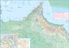
Uganda
Ordinær pris 199,00 krThe Jewel of Africa, Uganda is a lovely country to visit. Most of the development is in the south, close to Lake Victoria. To me, the most interesting parts are the game parks in the far west and in the far north, but the Mount Elgon area is interesting as well. This updated map also includes a large inset map of Kampala, the capital. The map has been updated to last for the next few years and, by being printed on plastic, is guaranteed to remain durable as well as waterproof.
United Arab Emirates & Abu Dhabi
Ordinær pris 169,00 krITM har kart over hele verden og de spesialiserer seg på land litt utenfor allfarvei. Beliggenheten til landets nasjonalparker, historiske monumenter, de viktigste veiene og lignende finner du inkludert i kartene. Samtlige landkart har ofte et bykart over hovedstaden.
We are pleased to release this brand new ITMB title. Abu Dhabi is one of the leading Emirates that are rapidly becoming vacation heavens for Europeans who don't want the long flights to Asian destinations. The city is so modern it almost squeaks. The palace is a world-class wonder, the seafront Corniche is a marvelous beach, and the central shopping area offers everything from hamburgers to Gucci bags. Motorways now connect the city state to nearby Dubai and to Oman, with a recently-completed one along the coastline to the Saudi border.
The reverse side of the map is an updated edition of the entire United Arab Emirates and most of Oman, with new motorways seemingly everywhere. A large inset map of central Dubai is included, along with a good one of Muscat. We docked at Abu Dhabi's cruise ship terminal during our visit and were impressed by the extent of urbanization of the city.
United Arab Emirates & Dubai
Ordinær pris 199,00 krITM har kart over hele verden og de spesialiserer seg på land litt utenfor allfarvei. Beliggenheten til landets nasjonalparker, historiske monumenter, de viktigste veiene og lignende finner du inkludert i kartene. Samtlige landkart har ofte et bykart over hovedstaden.
Fra ITM: Dubai is truly becoming a very popular travel destination and the loose federation of sheikdoms collectively known as the United Arab Emirates is growing in popularity with each passing year. Despite the turmoil affecting both Israel and Iran, this part of the Middle East is open for business and peaceful. Side 1 concentrates on the overall region from the eastern border of the UAE to its interaction with Oman. It also has an excellent inset map of Abu Dhabi, the capital of the UAE. Side 2 concentrates on Dubai itself as the largest urban area. Dubai has an extensive and interesting old town on the east bank of the Dubai Creek, which is where most of the hotels and the huge international airport are located. The ‘new town’ is on the left bank, and this is where one finds Western-style shopping areas, high-rise towers, the rapid transit line, and the main motorway out of town. The World Trade Center and Emirates Towers are also centrally located. The man-made Coastal Projects are shown in insets.
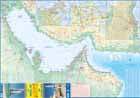
United Arab Emirates & Gulf Cruising
Ordinær pris 169,00 krITM har kart over hele verden og de spesialiserer seg på land litt utenfor allfarvei. Beliggenheten til landets nasjonalparker, historiske monumenter, de viktigste veiene og lignende finner du inkludert i kartene. Samtlige landkart har ofte et bykart over hovedstaden.
From ITMB: The Gulf, in this case, is the Persian Gulf, or if you prefer, the Arabian Gulf or, if you wish to, the Iranian Gulf. Regardless of which name one prefers, it is the body of water between Iran and the Arabic Emirates of Bahrain, Qatar, Dubai, and Oman/Muscat. It is also a popular cruising locale, with ships operating from Dubai to various ports of call. It also covers a considerable amount of geography, so side 1 concentrates on the water area from Kuwait/Iraq/Iran south to Bahrain and Qatar, along the coastline of the UAE to Oman and the Straits of Hormus, and along the coast of Oman to Muscat. It also includes inset maps of Manama (Bahrain), and Doha (Qatar), for the convenience of users. The second side of the map shows all of the United Arab Emirates and most of Oman, with insets of central Dubai and Muscat. Each side includes a listing of the top attractions of the side being shown. This is the third of ITMB’s growing range of cruising maps. We believe that the future of travel includes cruises as a popular means of exploring exotic travel destinations while retaining a comfortable environment. My wife and I cruised the Gulf a couple of years ago and found cruising to be an excellent way to explore several different countries that would be difficult to reach in any other manner. One day, I hope that cruises in this part of the world will extend to ports of call in Kuwait, Iraq, and Iran.
USA/Canada: Alaska's Inside Passage & British Columbia Coast
Ordinær pris 199,00 krThis is a new map for us, combining both the Canadian and the American portions of the Pacific coastline north from the Seattle area to the Alaska Panhandle, ending at the Glacier Bay National Park, which extends considerably north of the Bay itself. Side one concentrates on the Canadian portion, from Victoria north to the Queen Charlotte/Haida Gwaii islands, showing ferry routes and the routes most favoured by cruise ships. As a coastal map, it doesnt go very far inland, but shows the Coastal mountain range to good advantage.
Side two provides a very detailed map of that portion of Alaska known as the Panhandle a series of islands north and west of Canada that is very popular with cruisers. All parks and cruise line routes are shown. Interestingly, at the top end of Glacier Bay, the Canadian border splits the Panhandle from the rest of Alaska; not intentionally, but when the border was agreed upon in the early 1900s, no one realized that the glacier on that site might one day melt. Well, melt it has, leaving a kilometre-long stretch of beach that is part of Canada! Regardless, this map completes ITMB mapping of the Pacific coastline of North America rom the Bering Sea to Panama, a cartographic task that began decades ago.
USA: Alaska
Ordinær pris 169,00 krITM har kart over hele verden og de spesialiserer seg på land litt utenfor allfarvei. Beliggenheten til landets nasjonalparker, historiske monumenter, de viktigste veiene o.L. Finner du inkludert i kartene. Samtlige landkart har ofte et bykart over hovedstaden.
Fra ITM: The State of Alaska is a perennial best-seller. The area is emerging from Covid and tourism is returning. Now is the appropriate time to stock up for those planning a visit in the spring and summer months. Cruises will start operating again in May, and this is the most popular way to reach Alaska from Seattle or Vancouver, while enjoying ports of call along the way. If you do a cruise, make sure that you note the glacier at the northern end of Glacier Bay, which all ships visit. It has retreated to the point where a land mass is visible. That’s Canada. The border was set when the Icefield extended quite a ways further south, and no one realized at that time that there was no land under the ice. Technically, Alaska is now two parts – the peninsula and the mainland! Don’t tell the Americans!
USA: Appalachian Trail
Ordinær pris 199,00 krThis is a new venture for ITMB, although we have published several recreational hiking maps over the years. The Appalachian mountain range was the original western boundary of the American colonies while under British rule. Everything west of there was technically the French possession of Louisiana Territory, called by American settlers ‘Indian country’. Nowadays, it is a massive recreational hinterland for east coast residents wanting to escape overcrowded cities. The National Parks Service maintains the trail and a series of overnight huts.
Most people only hike a portion of the trail, but for the dedicated hiker, the trail is a great adventure. We have divided the length of the trail into four natural regions: Maine into New York State, Connecticut south to Maryland, Maryland to Virginia, and Virginia to Georgia, to its traditional end at Springer Mountain. This is a demanding trail hike, but one of the most popular in the world.
USA: Arizona & New Mexico
Ordinær pris 169,00 krThis version includes two separate covers, one for each state, to enhance marketing possibilities, and the addition of two Top Attractions listings, one for each state. The Arizona side has a detailed inset map of Flagstaff, showing the path of Route 66 through the city streets. The New Mexico side includes a large inset of Albuquerque, also including the Route 66 passageway through the city.
USA: California
Ordinær pris 199,00 krThe American State of California has almost as many residents as all of Canada. I wonder how many of them are ex-pat Canucks? Regardless, this double-sided map shows the attractions of the state in amazing detail. Side 1 concentrates on the northern half, with a large inset map of San Francisco. A fairly large portion of Nevada shows as well, but with less detail.
Side 2 continues south to the Mexican border and east to Arizona, with a detailed inset map of central Los Angeles included. By the shape of California, all of southern Nevada is included as well, including the all-important wasteland of Las Vegas. All motorways are clearly shown, including those in greater Los Angeles. All state highways are also shown, as well as most secondary connecting roads. Parks, points of interest, beaches, redwood forests, and distances between major communities are also shown. The state is blessed with interesting offshore islands, such as Catalina, San Clemente, and the Channel Islands, all of which are included.
USA: Chicago & Illinois
Ordinær pris 199,00 krITM har kart over hele verden og de spesialiserer seg på land litt utenfor allfarvei. Beliggenheten til landets nasjonalparker, historiske monumenter, de viktigste veiene og lignende finner du inkludert i kartene. Samtlige landkart har ofte et bykart over hovedstaden.
Fra ITM: Chicago is one of the largest cities in the USA and has long been famous for its rail hub joining lines from the east coast to those serving the western regions. It is also the start (or the finish) of famed Route 66, the first paved highway to the Pacific. Side 1 covers the city from the convention centre north to Wrigleyville and from the lakefront west to Western Avenue, with a large inset of Greater Chicago and another of Oak Park (famous for being the home of Frank Lloyd Wright). Side 2 is a brand new map for ITMB, being of the great state of Illinois, of which Chicago is a small part. This side traces Route 66 southwest from its origins in downtown Chicago to somewhat beyond St. Louis, where the national highway continues into Missouri. This map starts on Wisconsin in the north, at Minneapolis, and continues south to western Kentucky, ending at Nashville, Tennessee and is loaded with touristic attractions that are sure to delight visitors.
Publisert: 2025
Innbinding: falset
Material: vanntettpapir
Målestokk: 1:12,000/1:1,000,000
USA: Grand Canyon & Arizona
Ordinær pris 169,00 krArizona is an amazingly attractive State to visit, with Route 66 attractions in the north, bustling Phoenix in the centre, and a strongly-influenced Mexican influence in the south. Thus, a travel map for the state makes sense, and this one shows camping sites, local attractions (including Tombstone) and includes inset maps for Flagstaff and Grand Canyon Village. Its main attraction, however, is Grand Canyon, a deep defile carved out over millennia by the Colorado River, on its way to the Gulf of Mexico. This is one of nature's wonders, and a "must see" for everyone.
This results in a very interesting and useful map, covering both one of the most interesting States in America AND one of the great natural phenomena of the world. The map is printed on waterproof and biodegradable stone paper, which is a technological marvel in its own right, in this case for durability rather than to protect against moisture.