317 produkter
317 produkter


317 produkter
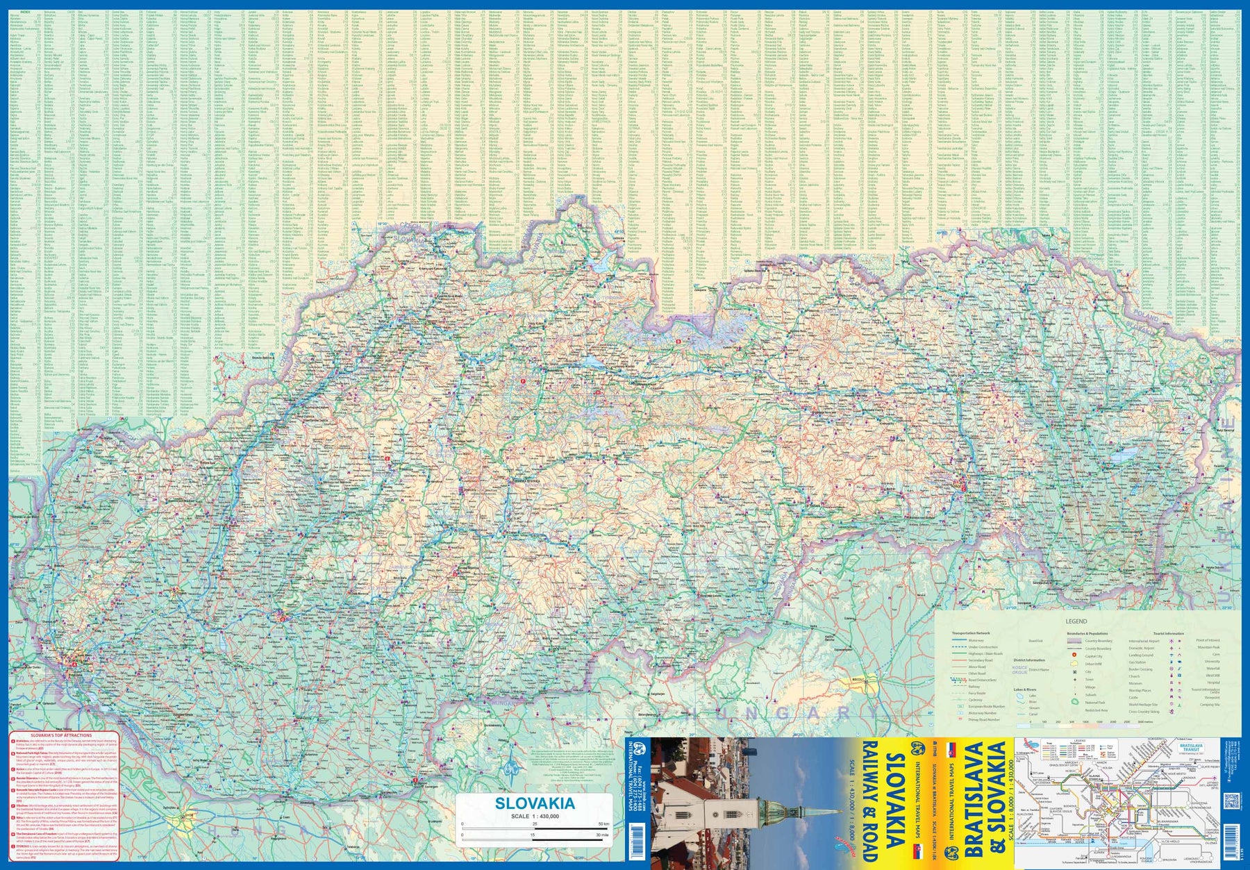
Slovakia - Railway & Road
Ordinær pris 169,00 krAs tourism to the eastern reaches of Europe becomes more popular, Slovakia is well-positioned to present an attractive opportunity for exploration. ITMB previously included this country with adjacent Hungary, but now we have expanded coverage and included a detailed map of Bratislava (1:8.000). Side 1 (1:430.000) shows the elongated country from its Austrian and Czech borders to its increasingly important border with Ukraine. As usual, we have included a listing of Top Attractions, such as the little-known towns of Kosice, Banska Stiavnica, and Sturovo, as well as the karst underground caves of Demanova and the fairy tale castle of Bojnice.
Side 2 portrays the capital city of Bratislava in excellent detail, showing the Danube River and the old town in great detail, along with the newer outlying areas of Petrzalka and Ruzinov. The map is printed on waterproof stone paper for durability. Legend Includes: Roads by classification, Rivers and Lakes, National Park, Airports, Points of Interests, Highways, Main Roads, Zoos, Fishing, and much more...
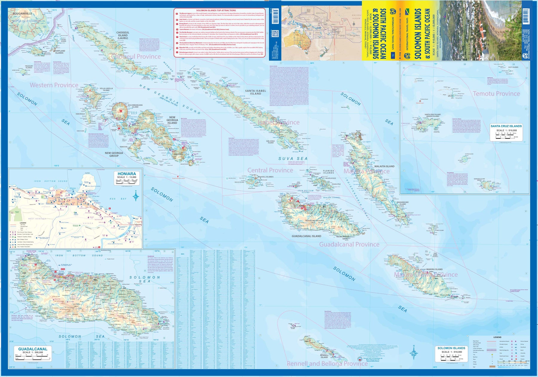
Solomon Islands & South Pacific Ocean
Ordinær pris 169,00 krITM har kart over hele verden og de spesialiserer seg på land litt utenfor allfarvei. Beliggenheten til landets nasjonalparker, historiske monumenter, de viktigste veiene o.L. Finner du inkludert i kartene. Samtlige landkart har ofte et bykart over hovedstaden.
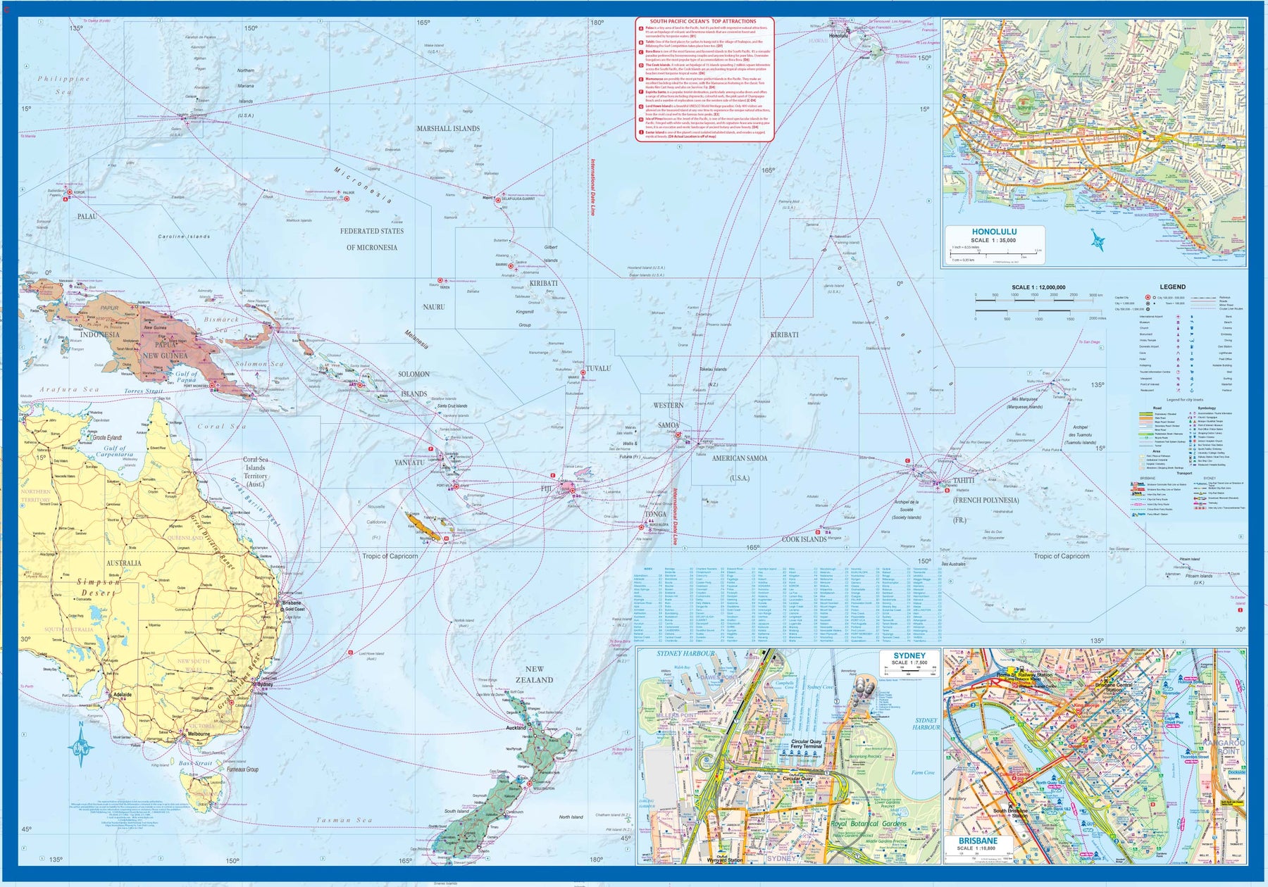
Fra ITM: The Solomon Islands are among the more popular touristic destinations of the South Pacific. Side 1 shows Guadalcanal and an inset of the capital, Honiara, and other islands made famous by fighting in WW2 - Choiseul, New Georgia, and Santa Isabel. The Santa Cruz Islands are shown as an inset. The country has been independent since 1978. Side 2 is a new venture for ITMB - a map of the entire South Pacific, showing cruise routes in the region covered, from Hawaii in the north to New Zealand in the south and from Indonesian New Guinea to the isolated Pitcairn Islands in the east. Inset maps of Honolulu, Sydney, and Brisbane are included, but a nice touch is to show underwater mounts and the way they join together the various island nations.
Somalia & Horn of Africa
Ordinær pris 169,00 krITM har kart over hele verden og de spesialiserer seg på land litt utenfor allfarvei. Beliggenheten til landets nasjonalparker, historiske monumenter, de viktigste veiene og lignende finner du inkludert i kartene. Samtlige landkart har ofte et bykart over hovedstaden.
Fra ITM: 3rd Edition Somalia is one of the more itneresting off-the-beaten-path countries. The area around Mogadishu prefers to call itself Somalia, but controls only a portion of the overall country area. Then there is Jubaland, on the Kenyan border, aligned very closely to the former Italian colony boundaries of the same name. Truuly, an amazing juxtaposition of countries within countries! the reverse side of the sheet presents a vey interesting regional perspective of the area between the northern border of Ethiopia, a small portion of Sudan and a reasonable portion of South Sudan, all of Uganda, most of Kenya, all of Djibouti and a fair portion of Eritrea, as well as the former Aden portion of war-torn Yemen. The strategic island of Socotra is in the upper right corner. This is a fascinating regional map, never before published to my knowledge, of an extremely significant part of the world. Think of the following: Socotra guards and controls access to the Gulf of Aden and the Red Sea, leading to the Suez Canal. What an interesting part of the world! How can anyone not be captivated by such wonderfully exotic names as Hargeysa, Boosaaso, or Kismayyo? Somalia and the region of the Horn remain crucially important to world peace, so this map is important.
Publisert år: 2020
Innbinding: falset
Material: plastpapir
Målestokk: 1:1,700,000 / 1:2,400,000
South Africa: Cape Town & Garden Route
Ordinær pris 199,00 krCity plan Cape Town & Road map Garden Route Southern Africa.
An excellent map of Cape Town on tear-resistant Stone paper, covering the city in excellent detail, and a second full-sized map on the reverse side covering that portion of the country known as Cape Province; essentially, from Cape Town north to the Namibian border, east to the Transkei, and north to Potchefstroom. This encompasses the wine districts of Stellenbosch, the lovely towns of George and Knysna on the south coast, historic Port Elizabeth, the very interesting Transkei homeland, all of Lesotho, and the arid interior regions that resonate with history – Graaff Reinet, Bloemfontein, Kimberley, and Upington. One not-to-be-missed experience is Addo Elephant Park; another is Grahamstown; still another is Cape Agulhas, the southernmost point of land in Africa. An excellent and much-needed travel map!
Legend Includes: Roads by classification, Rivers and Lakes, National Park, Airports, Points of Interests, Highways, Main Roads, Zoos, Fishing, and much more...
South Korea & Seoul
Ordinær pris 199,00 krRoad map South Korea and city plan Seoul.
This edition covers from close to the international airport to well east of the city centre, and there is a regional inset map on the same side providing details of the immediate surrounding area. The other side shows the entire country,with its extensive road and rail network shown clearly. The country has a very efficient network of fast trains, making reaching any corner of the country a matter of only a few hours.
South Pacific: Cook Islands & East Pacific Cruising
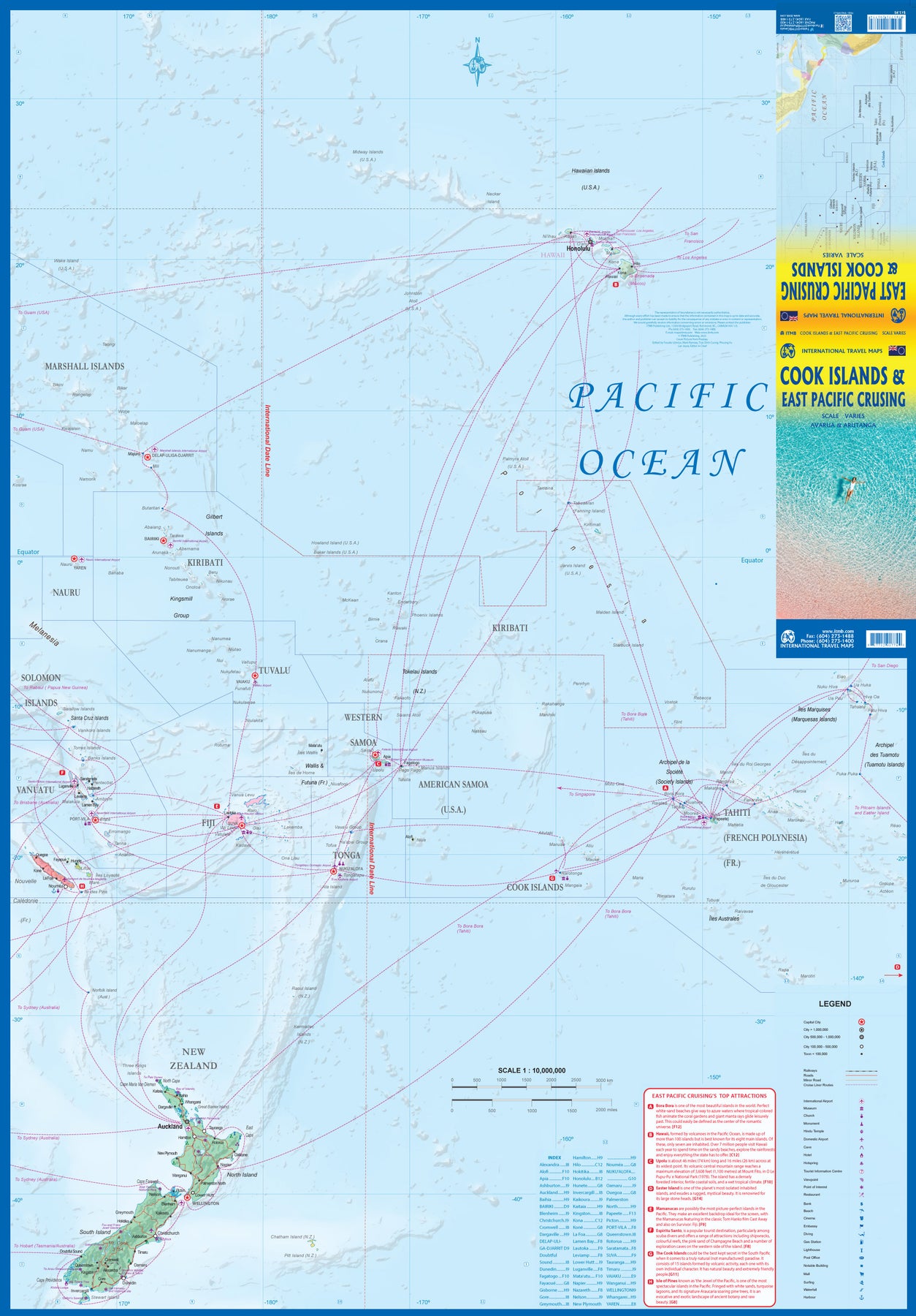
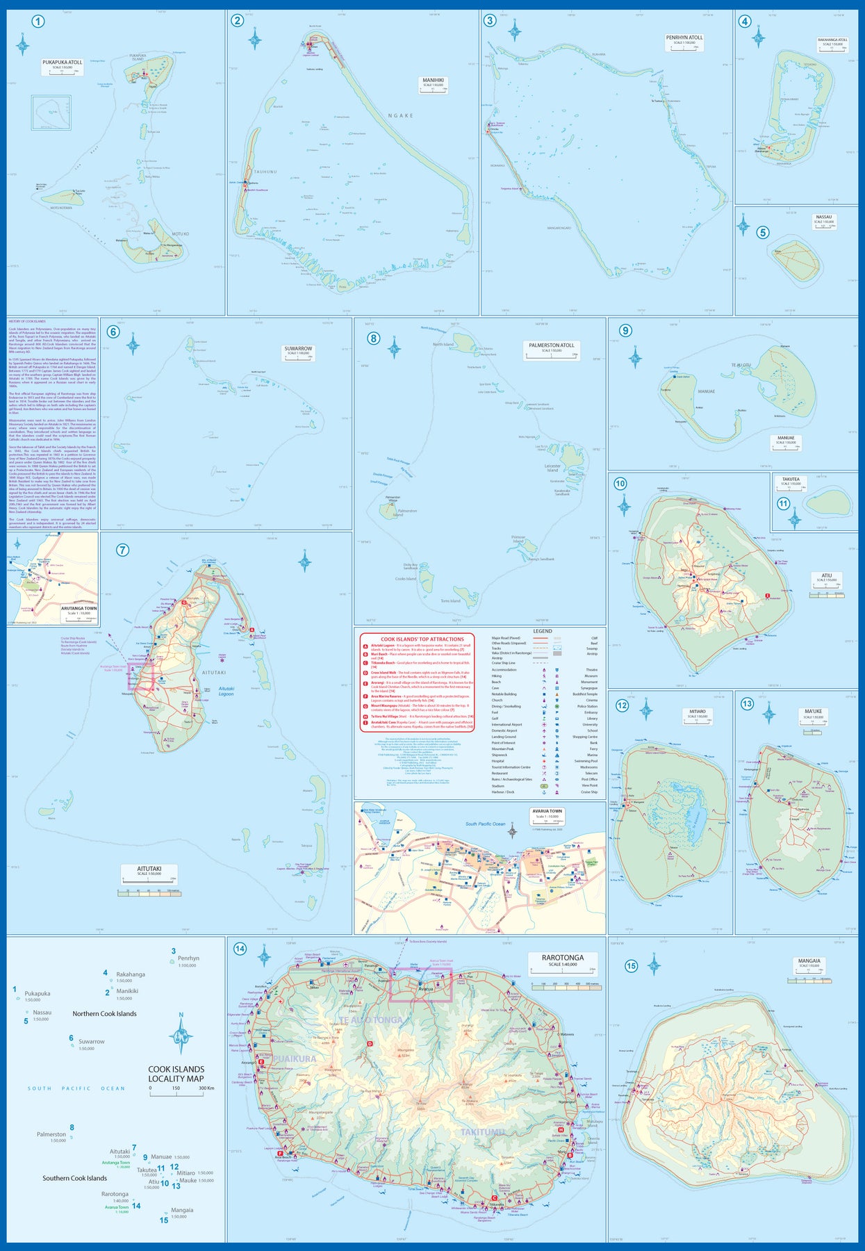
Ordinær pris 199,00 krThis is a combination map, focused on two travel realities. Side 1 is a detailed map of the main islands making up the Cook Island archipelago. To provide more detail, the country is an inset map in the lower left corner, with numbers in blue, up to 15. The main map on Side 1 is a series of inset maps providing excellent detail of individual islands, such as Raratonga, Mangaia, or Aitutaki, or island groupings of more northerly groupings that are little more than atolls, such as Penrhyn or Palmerston. The capital is Avarua, and an inset map is included; also one of Arutanga on Aitutaki. The country is well-positioned for tourism, and has many resorts, particularly on Raratonga.
Side 2 is a new map for ITMB, part of our growing Cruising line. This on covers the eastern portion of the South Pacific, from the Marshall Islands, Nauru, and the Solomons on the west to Hawaii and Tahiti on the east, and as far south as New Zealand. Other island nations included on this map are Kiribati, Tuvalu, Fiji, Samoa, and New Caledonia. By the nature of portraying a vast ocean, little detail of each island can be provided. The purpose of this map is to show routes followed by ships visiting the overall region. This is a rapidly-growing travel area for major cruise lines, and promises to be as attractive in the future as cruises in the Caribbean or Mediterranean. This region holds great prospects for the future. Besides, it is a lovely map to look at.
South Pacific: Cruising & Samoa
Ordinær pris 199,00 krIn conjunction with several cruise ship lines, ITM have prepared a map of the South Pacific Ocean, Which extends southwards from Hawai’i to the southern tip of New Zealand and eastwards from central Australia/Papua New Guinea to the Pitcairn Islands. Thus, it does not include the popular South East Asia and China coast routes. We think this has to change at a time when 25,000,000 people are travelling by cruise ships. At the same time, we must keep coverage area relevant for those end users of the artwork. Even at 1:12M, most of the area covered is water, with island countries such as Fiji, Tonga, Kiribati, Tahiti, and the Cook Islands being visible, but without detail.
For those readers more familiar with Caribbean or Mediterranean cruising, the reason for our focus on the South Pacific is due to the fact that this region of the world is the fastest-growing portion of cruise travel growth. The map of the South Pacific region fills one side of the map. The reverse side of the artwork covers the two entities known collectively as Samoa, which has been included for two reasons. First, it is in the centre of the South Pacific and several cruise companies stop at Pago Pago. Second, the two Samoas form a unit that is not contiguous with any other part of the vast Pacific region. Independent Western Samoa consists of two main islands and two small islands, which have been portrayed at 1:160,000 scale. An inset map of the capital, Apia is included.
South Pacific: Fiji & Tonga
Ordinær pris 199,00 krITM har kart over hele verden og de spesialiserer seg på land litt utenfor allfarvei. Beliggenheten til landets nasjonalparker, historiske monumenter, de viktigste veiene o.L. Finner du inkludert i kartene. Samtlige landkart har ofte et bykart over hovedstaden.
Fra ITM: The South Pacific offers a wealth of scenic and interesting countries to visit. Fiji is one of the most popular, consisting of two major islands and dozens of smaller ones. Suva, the capital, is portrayed with a detailed inset map. The southern island of Viti Levu is more popular with tourists, but the more northerly island of Vanua Levu is more relaxing. The second side shows the islands of Tonga. This is less visited than Fiji, just to its west, and consists of dozens of islands and many resort hotels. The capital of Nuku’alofa is small enough to walk everywhere and is the point of embarkation for most of the other islands. Captain Cook landed on tiny Vatoa Island in 1774, and the Bounty visited volcanic Tofua Island in 1789. This is a Pacific paradise!
Publisert år: 2025
Innbinding: falset
Material: papir
Målestokk: flere
South Pacific: Oceania Cruising & New Caledonia
Ordinær pris 199,00 krThe South Pacific island complex known as New Caledonia, or Nouvelle Caledonie in French, consists of a main island and half a dozen smaller islands (collectively called the Loyalty Islands. It is an overseas possession of France and uses the Euro as its currency. It is located about halfway between Australia and Fiji and is south of Vanuatu. The main island is one of the larger land masses in the Pacific, with a reasonably well-developed road infrastructure linking the capital city of Naomea with other urban areas. There are resort hotels at various locations along the coastline, but this is a territory that one would have to regard as being adventuresome. Most of the attractions are concentrated in the vicinity of the capital. The islands were important surveillance zones during WW2, and the territory is popular with Australians and New Zealanders.
The reverse side of the sheet portrays the South Pacific for cruising, covering from Hawaii to the Marianas, down to New Guinea, and includes the eastern half of Australia, all of New Zealand, American Samoa, Fiji, and Tonga in the centre, with Tuvalu, Kiribati, and the Marshall Islands to the north and the Cook Islands and Tahiti to the east. This is an increasingly popular part of the world for cruise ship activity, as it combines affluent population areas in Australasia and the USA with exotic, but safe, travel destinations that are expensive to reach by any means except cruise ships. This is a brand new title for ITMB and expands our coverage of both the southern portions of the Pacific with yet another first-time map.
Spain
Ordinær pris 199,00 krSpain is an ancient land full of historic sites dating from Roman times or the Moorish occupation. As a country, it divides naturally into northeastern Catalonia, northwestern Galicia, Central Toledo, and the Mediterranean coastal regions. This map is double-sided, with the portion closer to Portugal on one side and the Mediterranean coast from the French border to Granada on the other side. Spain has invested heavily in road improvements since joining the EU and has enthusiastically embraced rail line improvements in line with the EU’s efforts to wean travellers away from automobiles. This map emphasizes the railway network. The map also includes inset maps for the Canary Islands and the Balearics in the Mediterranean.
Spain: Balearics - Mallorca; Ibiza & Menorca
Ordinær pris 199,00 krThe Balearic Islands in the western Mediterranean have been extremely popular travel destinations for centuries. Mallorca/Majorca and Ibiza have become favoured visits by cruise ships to these islands in recent years, but the warm climate has attracted visitors for a long time. Side 1 concentrates on the three major islands of Mallorca, Ibiza, and Menorca but includes the smaller islands of Formentera and Cabrera, along with an inset map showing the islands in relation to the Spanish mainland ports of Valencia and Barcelona. Side 2 focusses on cruising the entire western half of the Mediterranean, from Naples west to Gibraltar. Naturally, the Balearics end up right in the centre of the map, which also includes the islands of Corsica and Sardinia, both of which are becoming increasingly popular with those cruising. I hasten to add that cruising is the fastest growing segment of the entire travel industry, so is an important market for the mapping industry.
Spain: Mediterranean Coast
Ordinær pris 199,00 krSpain is one of the most popular travel destinations in Europe. The country is extremely diverse, reflecting its history. The coastal areas of the Mediterranean were probably first settled by Phoenicians, then Greeks, then Romans, and then Arabs before being brought into a united Spain at the time Columbus was seeking a sponsor to fund his proposed journey to discover new lands to the west. This map focuses on the coast from the French border south through Catalunya all the way to the Straits of Gibraltar and Cadiz. The offshore islands of Mallorca, Ibiza, and Menorca are included, as is the North African Spanish enclave of Ceuta and the British enclave of Gibraltar.
All road and rail lines are shown, including the new Cadiz to Madrid fast train. By the nature of mapping, a considerable amount of the interior is on the map as well, so this map is much more than just a coastal journey through Valencia and Murcia to reach Granada, although that would be a very enjoyable trip. The map is equally applicable to interior trips to Cordoba or Albacete as it is a map of the coast. However, its purpose is to show the attractions of the coast – beaches, resort areas, historic towns, forts, nature reserves, archaeological remains, and Top Attractions.
Spain: South Rail & Road
Ordinær pris 179,00 krThe southern half of Spain (and of Portugal, which is also included) consists of the portion from Toledo/Castellon south to the Mediterranean. Side 1 (the cover side) focuses on the eastern portion, from Granada to the coast, including the Balearic islands of Mallorca, Menorca, and Ibiza, and the other side the portion of Spain west of Granada, including that portion of Portugal from north of Lisbon to the Algarve. Gibraltar is included, as are the Straits and the Spanish enclave of Ceuta and part of Tangier. A large inset of the seven Canary Islands is also shown. This map completes our regional mapping of Spain (the other two titles are Spain North and Cataluña/Barcelona).
Spain has invested heavily in its train network, so we note both rapid train and regular train routes, as well as the expanding motorway network. Major touristic sites are noted, as always, with special attention to world heritage sites. The scale is excellent for those wanting to explore this portion of Spain at leisure.
Sri Lanka & India South
Ordinær pris 199,00 krThis edition is a considerable improvement on our previous one, benefitting from the extensive research trip we took to the emerald-shaped island shortly before the outbreak of Covid changed the world. We have re-introduced it as a map printed on waterproof paper, as such a format holds up well in a hot, humid climate. We visited all parts of the island and were quite impressed by the number of local hotels and resorts that we found and have added to the map. We were particularly gratified to discover progress on extending the motorway system for the country, much of it now probably delayed due to Covid.
The inset map of Colombo is particularly well-done. The second side of the sheet is a very detailed map of the southern third of India, from Nagpur to the southern tip of the country. Space constraints did not allow for inset maps, but several well-known cities are included – Mumbai, Hyderabad, Chennai, Pondicherry, Madurai, and Bengaluru (Bangalore) among them. India is a fascinating, if somewhat intimidating, place to visit, but is well-worth the time to do so.
Sudan & South Sudan
Ordinær pris 199,00 krConsidering that Sudan is locked into an even more brutal civil war than the one besetting Israel-Hamas, this might seem like an odd time to bring out our first-ever map of Sudan and South Sudan, but it may be an important area of the world to have an updated map of, to focus on a tragedy unfolding mostly unnoticed by the world at large. More than 10,000 locals have been slaughtered since a rebel group made an abortive grasp to overthrow the current government a couple of months ago, mostly in the Darfur region.
ITMB publishes maps to encourage touristic travel, but our maps also bear witness to atrocities and natural disasters and are widely used by selected governments and humanitarian aid groups thanks to the accuracy of our artwork. Side 1 concentrates on Sudan from its disputed (and closed) border with Egypt south to a little below Khartoum, the capital. An inset map of central Khartoum is also included.
Side 2 focusses on South Sudan from its borders with CAR, Congo, Uganda, and Kenya north to the still-contested border with Sudan and the southern provinces of that country. The most dominant feature of both Sudans is the Nile River (White Branch) that flows through both countries on its way to the Mediterranean. This is the first time that South Sudan has been so intensely mapped and is a credit to Lan’s team of cartographers to portray a country carved recently out of adversity and coping with intense tribal rivalries.
Surinam & French Guiana
Ordinær pris 149,00 krITM har kart over hele verden og de spesialiserer seg på land litt utenfor allfarvei. Beliggenheten til landets nasjonalparker, historiske monumenter, de viktigste veiene o.L. Finner du inkludert i kartene. Samtlige landkart har ofte et bykart over hovedstaden.
Publisert år: 2009
Innbinding: falset
Material: papir
Målestokk: 1:750000
Tahiti & French Polynesia
Ordinær pris 199,00 krAnyone who has visited Tahiti retains fond memories of a wonderful Polynesian paradise. This map shows the major islands of French Polynesia as a series of large insets on Side 1. An overall inset map showing the many islands is also shown, but for showing detail, one must expand the individual islands. The largest one is the volcanic Tahiti Nui, with the capital city of Pape’ete (or Papeete in English), for which a detailed inset map is included. Most visitors stay in the vicinity of Papeete, along the coast. We show several popular resorts. There is a good circular road around the island’s shoreline, but no roads in the interior. The island is joined to another, called Tahiti Iti, or Little Tahiti, and roads extend partway around this less-developed part of the combined island. Most of the other islands are rarely visited, although they have resorts, beaches, and a lifestyle of their own. Names like Huahine, Riatea, Tahaa, and Maiao may not be as familiar as they should be, but all can be reached by inter-island transportation. Moorea and Bora Bora are much better known, with numerous resorts along the coastline. Being a French Overseas Possession, Tahiti uses the Euro as a currency, so expect European prices! Tahiti is also a popular destination stop for cruise ships. The second side of the map covers a part of the world impossible to map well. The region known alternatively as Polynesia and as the South Pacific consists of a vast amount of water, dotted with small islands that are little more than the tips of mountains resting far below the surface. This map shows Hawaii at the upper edge and the northern tip of New Zealand at the bottom. The Queensland coast of Australia is at the far left, and the very isolated Pitcairn Islands at the eastern edge. In between are Cook Islands, Tahiti, Samoa, Fiji, the Solomons, Nauru, Kiribati, Micronesia, and the Marshall Islands. This vast expanse of ocean is becoming increasingly attractive as a cruise ship area, simply because it is the only way most of us could ever visit this region affordably. I like this map because it shows undersea mountain chains and names dozens of islands we’ve probably heard of and dreamed of visiting. Where exactly is Niue, for instance, or Fanning Island? Did you know that the USA has island colonial possessions all over the Pacific? Samoa is well known; how about Palmyra Atoll, Howland Island, the Bakers, or Swains Atoll? Lan has really created an enticing map; one looks at it in detail and starts making travel plans in one’s head!
Taiwan & Taipei
Ordinær pris 199,00 krTaiwan always reminds me of the “little engine that could”. Despite having to endure an extremely hostile neighbour, the country has prospered, is democratic, and is friendly and welcoming to visitors, despite the fact that most governments do not officially recognize its existence. Side 1 shows the capital city of Taipei, a bustling economic powerhouse on the Damshui River, close to the ocean. The city has numerous hotels and shopping areas, and a well-developed subway network.
The second side covers the complete island of Formosa from top to bottom in excellent detail, as well as the off-shore Penghu islands (these can be reached by ferries from Kaohsung or Dongshih). Most of the country’s development is on the western, or Taiwan Straits, side of the mountainous country, but to me the Taroka Gorge, leading inland from Hualien on the east coast, is one of the wonders of modern Asia. An inset map of Tainan in southeast Taiwan is also included.