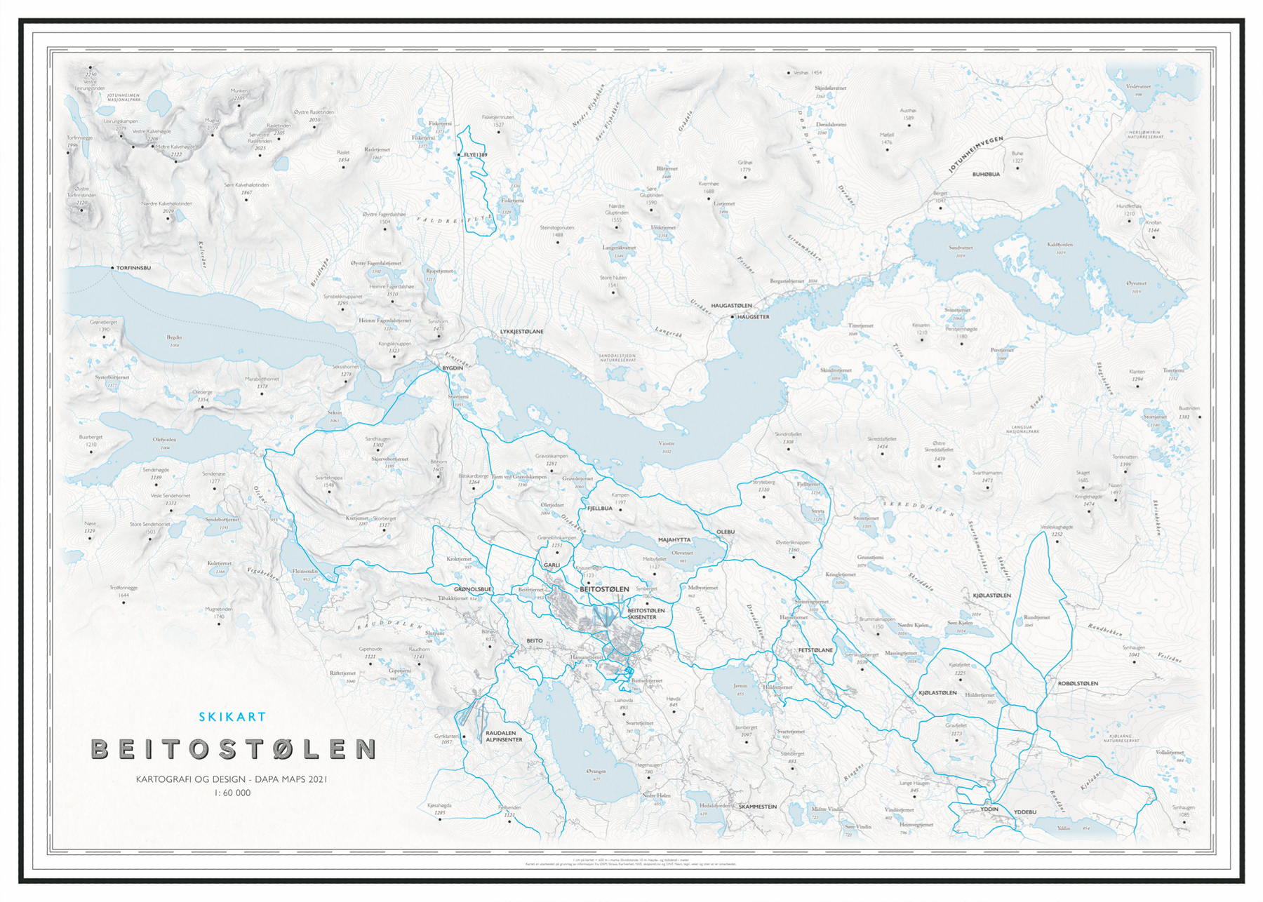
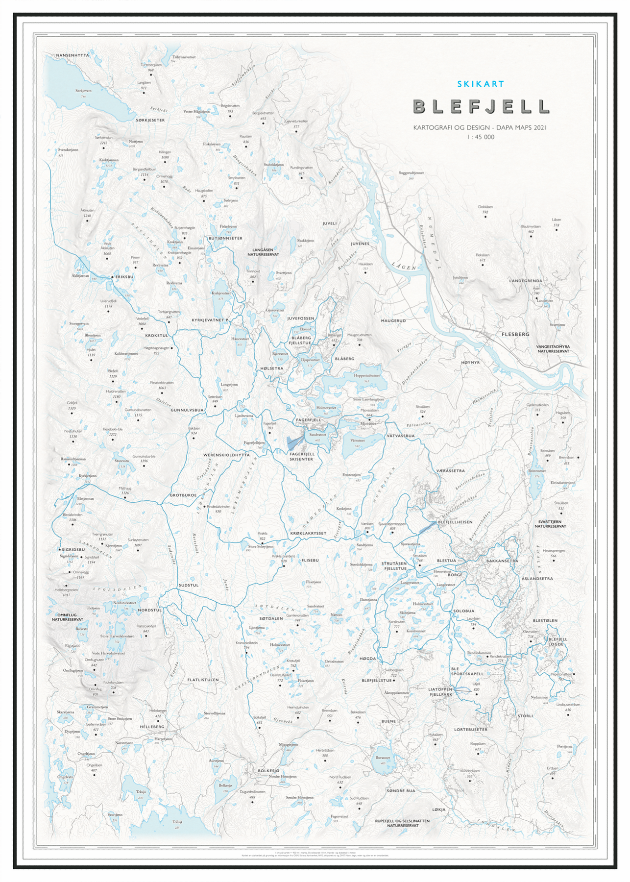
3044 produkter
3044 produkter
3044 produkter
Tour du Mont Blanc
Ordinær pris 299,00 krTour du Mont Blanc Trekking Map The only sheet map for the Tour du Mont Blanc that shows all accommodation, food and transport options. The entire trek and variants on a single sheet: perfect for planning and navigation.
Made specifically for the TMB by Knife Edge Outdoor Guidebooks: - English/French/German map key
Tour of Jungfrau Region
Ordinær pris 269,00 krThis guidebook describes a 111km circuit amid some of the most spectacular mountain scenery in all the Swiss Alps. The Tour of the Jungfrau Region is described as a clockwise hut-to-hut circuit, beginning at Schynige Platte and ending at Wilderswil, broken into 10 stages (with a number of high and low- level alternatives offered). The route is suitable for hikers with some alpine experience.
The 111km trek takes you in a horseshoe loop through the Bernese Oberland's most spectacular mountain scenery, in the shadow of such iconic peaks as Wetterhorn, Eiger, Monch and Jungfrau. In a journey of 9 to 10 days the Tour visits pastures, ridges, summits and passes, skirts exquisite mountain lakes and gazes on waterfalls, gorges and glaciers. The guide contains all the information needed, including a trek planner, maps and profiles.
On practically every stage modestly priced dormitories are available and, as meals are provided everywhere, walkers can trek unencumbered by heavy rucksacks.
Tourist & Motoring Atlas: Benelux 2024
Ordinær pris 239,00 krMichelin Road Atlas Benelux and North of France is the perfect companion for an enjoyable and safe drive. Convenient and easy to use thanks to its spiral bound cover. Michelin Road Atlas Benelux and North of France will provide you with precise and reliable information with its mapping scaled 1/150 000 for an enjoyable journey in Northern France, Belgium, Luxembourg and Netherlands.
Trekking Austria's Adlerweg
Ordinær pris 339,00 krThe Eagle's Way across the Austrian Alps in Tyrol.
A guidebook to Austria's Adlerweg (the Eagle's way) a long-distance trail from St Johann in Tirol in the east, passing through the historic town of Innsbruck at its mid-point before continuing to St Anton am Arlberg in the west. This waymarked 324km trek is presented in 24 stages ranging between 7 and 32km in length, with easier alternate routes provided for the most difficult stages. This guide features 1:50,000 mapping, accommodation details for the start and end points of each stage, which serve hearty meals and refreshments, and details on local transport, planning and local history.
Traversing the North Kakalpen Alps the route passes through the Wilderkaiser, Bradenberger Alpen, Rofangebirge, Karwendelgebirge, Wettersteinebirge and the Lechtaler Alpen ranges, enjoying views as far as Munich and the Swiss Alps. It is the perfect adventure for those looking for an alpine challenge.
Trekking Chamonix to Zermatt
Ordinær pris 349,00 krA guidebook to the classic Chamonix to Zermatt trek from Mont Blanc to the Matterhorn. The 225km Walker's Haute Route through the French and Swiss Alps crosses 11 passes, gains more than 14,000m in height and is a strong contender for the title of Most Beautiful Walk in Europe. The high-level route is described in 14 day stages, with optional variants, and is suitable for walkers with a good level of fitness and some previous alpine trekking experience.
Alongside clear route descriptions and mapping for each stage of the trek, there is essential practical information on travel to Chamonix and return from Zermatt, as well as advice on accommodation in alpine villages and mountain refuges, trekking safety, equipment, itinerary planning and preparation. Taking 2 weeks to complete, this challenging but rewarding trek encompasses views of the greatest collection of 4000m peaks in the Alps - Mont Blanc, the Grand Combin, Dent Blanche, Weisshorn and the Matterhorn - and visits some of the most spectacular valleys, including the Val d'Herens, Val d'Annivers and the Mattertal.
Trekking in Austria's Hohe Tauern
Ordinær pris 349,00 krA guidebook to four treks in Austria´s Hohe Tauern: the 61km Reichen Group Hut-to-Hut Rucksack Route, the 68km Venediger Group Hut-to-Hut Rucksack Route, the 78km Venediger Glacier Tour and the 99km Glockner Rucksack Route. Whereas the three rucksack routes require only good fitness and mountain walking experience, the glacier tour involves glacier crossings. The Reichen Rucksack Route is presented in 7 stages, the Venediger Rucksack Route in 7, the Venediger Glacier Tour in 8 and the Glockner Rucksack Route in 9.
Also included are optional ascents of neighbouring peaks, including Austria´s highest, the Gross Glockner, some of which may require specialist equipment and mountaineering skills. Clear route description illustrated with 1:50,000 mappingElevation profiles for each trekComprehensive hut directoryDetailed summary of each day´s challenges and any potential hazardsIdeas for linking stages of the routes to complete a traverse of the Hohe Tauern National Park and an ascent of the Gross Glockner.
ISBN: 9781786310644
Trekking in Austria's Stubai Alps
Ordinær pris 359,00 krOf all the many Alpine areas, few can match the Stubai Alps in the Austrian Province of Tyrol. With shapely peaks, good paths and some of the best huts in the Alps, it offers ideal hiking routes for mountain walkers. Trekking in the Stubai Alps offers two brilliant routes for the experienced walker: the Rucksack Route and Glacier Tour, both of which fit easily in a two week holiday.
Trekking in Mallorca GR221
Ordinær pris 319,00 krThis guidebook describes the GR221, a 140km (87 mile) long-distance trail through northwestern Mallorca, from Port d'Andratx to Pollenca. Also known as the 'Ruta de Pedra en Sec' ('the Drystone Route'), the GR221 is a celebration of Mallorca's limestone heritage, taking in many historic drystone structures as it traverses the rocky peaks of the Serra de Tramuntana. Following old stone-paved paths and mule trails, it showcases the region's beautiful landscape of mountains, forests and cultivated terraces, as well as its spectacular coastline.
The GR221 can be walked in 1-2 weeks, although the guide also covers 3 alternative start-points and 3 alternative finishes, which would allow for a shorter trek. The main route is presented in 10 stages of 8.5-20.5km (5-13 miles), with a handful of optional detours to bag neighbouring summits. Detailed route description is accompanied by 1:25,000 mapping and inspirational photography, plus a wealth of information on local points of interest.
Accommodation and travel are also thoroughly covered: the trail boasts good transport links and plentiful facilities on route, with accommodation in welcoming mountain villages and the occasional 'refugi'. A comprehensive introduction offers the opportunity to discover more about the region's diverse plants and wildlife and unique history and culture, and an English-Spanish-Catalan glossary can be found in the appendix. With a favourable climate and stunning scenery, the Serra de Tramuntana has much to tempt the walker.
The GR221 Drystone Route represents an ideal way to explore this fascinating World Heritage Site.
Trekking in The Alps
Ordinær pris 399,00 krAn inspirational larger format guidebook to 20 summer treks in the Alps across Italy, Austria, Switzerland, France and Slovenia, including the classics such as the Tour of Mont Blanc and lesser-known routes like the Traverse of the Slovenian Alps. Perfect for planning, the treks included are: Tour of Mont Blanc, Tour of the Matterhorn, Tour of Monte Rosa, Walker's Haute Route, Tour of the Jungfrau Region, Tour of the Vanoise and Dolomites AV 1 & 2; (longer trans-Alpine routes) GR5 (Lake Geneva to Nice), Eastern Alps E5, Italian Alps GTA and the Traverse of the Slovenian Alps; and (for the Alpine adventurer) Alpine Pass Route, Tour of the Oisans, Tour of the Queyras, Tour of Mont Ruan, Stubai High Route, Zillertal High Route, Gran Paradiso AV2 and the Ratikon Hoehenweg. Outline schedules for each trek allow you compare the routes and become inspired to take up the challenge.
Trekking in The Apennines
Ordinær pris 249,00 krThis guidebook describes the Grande Escursione Appenninica (GEA), a nearly 400km long, three week trek crossing the Apennines in 23 stages, from Bocca Trabaria to Passo Due Santi on the edge of Liguria. The route dips in and out of Tuscany and Emilia-Romagna, never dropping below 400 metres. Best walked between spring and autumn, it is suitable for any reasonably fit walker, and this guidebook provides step-by-step route descriptions, accompanied by detailed mapping.
There are transport options for joining and leaving the walk at a number of points, making it perfect for undertaking in small sections or single-day walks. There are suggestions for accommodation en route in comfortable guest houses and alpine-style huts, making it essential reading for anyone undertaking the GEA. The Apennines are Italy's best-kept secret.
Trekking Italy Grande Traversata delle Alpi
Ordinær pris 349,00 krA guidebook to Italy's Grande Traversata delle Alpi (GTA) trek through the western Italian Alps. The 809km (503 mile) route is presented in 55 stages with each stage ranging from 7-26km (4-16 miles). Beginning at the Nufenen pass at the Swiss border the route traverses the Lepontine, Pennine, Graian, Cottian and Maritime Alps to finish at Ventimiglia on the Mediterranean coast.
With nearly 60,000m of ascent this route is suitable for fit and experienced alpine trekkers. This guidebook contains route description and 1:100,000 mapping for each stage as well as information on the region's history, culture and wildlife. Accommodation, facilities and public transport information is also given to help with trek planning.
Italy's western Alps is an area of high mountain passes, sparkling lakes, clean air, and alpine meadows rich in wildflowers. With a network of paths that enabled travel long before the motor car, the region is ideally suited to exploring on foot. From Switzerland to the Mediterranean, the GTA enables the visitor to travel the old ways through the mountains, hearing the stories, sampling the regional specialties in food and wine, and experiencing the famously warm welcome of the Italian people.
Trekking Portugal's Rota Vicentina
Ordinær pris 349,00 krA guidebook to walking the 224km (140 mile) Rota Vicentina, between Santiago do Cacém and Cabo de São Vicente. This long-distance trail following Portugal’s Atlantic coastline through the Alentejo and Algarve regions is suitable for all fit walkers and is best experienced Spring and Autumn.
Trekking Switzerland’s Jura Crest Trail
Ordinær pris 249,00 krA two week trek from Zürich to Geneva.
This guide presents Switzerland's Jura Crest Trail or Cretes du Jura (also known as the Jura High Route and Swiss national route 5. This 310km long-distance route traverses the sub-alpine mountains of the Swiss Jura from Dielsdorf near Zurich to Nyon on the shores of Lac Leman (Lake Geneva), running roughly parallel to the Swiss-French border. With over 13,500m of ascent, the trail demands a moderate level of fitness and can be comfortably completed in around a fortnight.
The Jura Crest Trail is easily accessed from Zurich and Geneva. The region boasts excellent walking infrastructure and facilities, and although the trail crosses the mountains, you are seldom too far from civilisation. The guide contains all the information you need to plan and walk the route.
You'll find advice on transport and comprehensive details of accommodation and refreshments. The trek itself is presented from east to west in 14 stages of 12-32km, with step-by-step route description accompanied by clear mapping and notes on local points of interest. The Jura Crest Trail boasts far-reaching views of the Bernese Oberland, the Haute Savoie and the Rhine and Rhone Valleys, and is rich in geological, natural and historical interest.
Passing through woodland and alpine meadows and crossing rolling limestone plateaux, highlights include the spectacular amphitheatre of the Creux du Van, the medieval towns of Baden and Brugg, and Lac de Joux, the largest lake in the Jura mountains.
Publisert år: 2019
Sider nr: 179
Trekking the Andalucian Coast to Coast-Walk
Ordinær pris 249,00 krGuidebook to the Andalucian Coast to Coast Walk, a 416km, 21-day route from Maro on the Mediterranean coast to Bolonia, on the Atlantic. The route, which passes through 7 Natural Parks, links some of Andalucia's most beautiful villages and passes historical sites of both Roman and Moorish origins, including Ronda and Tarifa.
Trekking the Dolomites AV1
Ordinær pris 349,00 krThis is only guidebook exclusively for the AV1 and contains everything needed plan and walk Italy's most popular long-distance route. The guidebook contains real maps - Tabacco 1:25,000 - the finest maps available for the Dolomites, thus making navigation easy with no need to carry additional maps. The AV1 is the premier route in the Dolomites.
It is the perfect way to explore the range's exquisite beauty and fascinating WW1 history. The AV1 is a linear route between Lago di Braies in the north and Belluno in the south. On the journey, you cross incredible high mountain passes, travel through magnificent valleys, exquisite alpine plateaus, wonderful grassy pastures and carpets of wildflowers.
Unlike some alpine treks, the AV1 never enters villages or hamlets: fabulous accommodation is available in remote mountain huts cleverly spaced out along the route. Places with views that most people dream of but few will ever see. This is without a doubt a trek that should be on your bucket list.
With the right preparation, planning and approach the AV1 is perfectly manageable for most people of reasonable fitness. It is challenging but achievable. Most of what you need to know to prepare for the AV1 is here within these pages.
And the entire route is described in detail to guide you on the trek itself. Furthermore, unlike other books, this one contains Real Maps: for each stage, there is a 1:25,000 scale map.
Trekking The Giant's Trail: Alta Via 1
Ordinær pris 309,00 krItaly's Alta Via 1, a 180km trail through the Italian Alps following the northern flank of the Aosta Valley, boasts magnificent views of the Alpine giants: Mont Blanc, the Matterhorn, the Grand Combin and Monte Rosa. Indeed, it is sometimes known as the Giants' Trail and can be combined with a sister-route, the Alta Via 2 (covered in a separate Cicerone guide), which runs along the southern flank of the valley, to form the Tor des Geants. Stretching from Donnas to Courmayeur, the Alta Via 1 offers fantastic alpine walking, with welcoming refuges and small hotels providing overnight accommodation (and great food) along the way.
The guide presents the route in two sections, for the advantage of those who can't spare the full fortnight-plus needed to walk the entire AV1. The trail is described in 16 stages, with alternative stages covering some popular variants, including an optional detour to visit the famed monastery at the Great St Bernard Pass. Each stage includes clear route description and mapping, plus notes on local points of interest and accommodation options.
An alternative itinerary, list of useful contacts, kitlist and glossary can be found in the appendices. The AV1 crosses cols of nearly 3000m as it traverses the side-valleys of the main Aosta Valley. Suited to those with some of experience of alpine trekking, the walking is demanding but without technical difficulty.
And the rewards are many: quieter huts, breathtaking vistas and a chance to immerse yourself in fabulous mountain landscapes overlooked by soaring, snow-clad giants.
Trekking The GR5 Trail: Vosges and Jura
Ordinær pris 249,00 krGuidebook to a 687km (427 mile) trek through eastern France, traversing the Vosges and the Haut-Jura plateau. The route follows the GR53 from Wissembourg to Schirmeck, before picking up the central section of the GR5 from Schirmeck to Nyon on Lake Geneva, taking in wooded and grassy hills, river gorges and fascinating castle ruins.