Filter
- Afghanistan
- Armenia
- Aserbajdsjan
- Australia
- Bahrain
- Bangladesh
- Bhutan
- Bolivia
- Brunei
- Canada
- Ecuador
- Estland
- Filippinene
- Finland
- Frankrike
- Georgia
- Hviterussland
- India
- Indonesia
- Irak
- Iran
- Irland
- Israel
- Italia
- Japan
- Jemen
- Jordan
- Kambodsja
- Kasakhstan
- Kina
- Kirgisistan
- Kuwait
- Laos
- Latvia
- Libanon
- Litauen
- Malaysia
- Maldivene
- Mexico
- Mongolia
- Nepal
- New Zealand
- Nord-Korea
- Norge
- Oman
- Pakistan
- Palestina
- Polen
- Qatar
- Russland
- Serbia
- Singapore
- Spania
- Sri Lanka
- Sveits
- Syria
- Sør-Korea
- Tadsjikistan
- Taiwan
- Thailand
- Turkmenistan
- Tyrkia
- Tyskland
- Ukraina
- Usbekistan
- Vietnam
- Zambia
- Zimbabwe
- Øst-Timor
- Østerrike
509 produkter
509 produkter
Utsolgt
India
ITM
149,00 kr


United Arab Emirates & Abu Dhabi
Ordinær pris 169,00 kr/
Mva inkludert
Frakt beregnes i kassen.
ITM har kart over hele verden og de spesialiserer seg på land litt utenfor allfarvei. Beliggenheten til landets nasjonalparker, historiske monumenter, de viktigste veiene og lignende finner du inkludert i kartene. Samtlige landkart har ofte et bykart over hovedstaden.
We are pleased to release this brand new ITMB title. Abu Dhabi is one of the leading Emirates that are rapidly becoming vacation heavens for Europeans who don't want the long flights to Asian destinations. The city is so modern it almost squeaks. The palace is a world-class wonder, the seafront Corniche is a marvelous beach, and the central shopping area offers everything from hamburgers to Gucci bags. Motorways now connect the city state to nearby Dubai and to Oman, with a recently-completed one along the coastline to the Saudi border.
The reverse side of the map is an updated edition of the entire United Arab Emirates and most of Oman, with new motorways seemingly everywhere. A large inset map of central Dubai is included, along with a good one of Muscat. We docked at Abu Dhabi's cruise ship terminal during our visit and were impressed by the extent of urbanization of the city.
- Publisert: Aug. 2022
- Innbinding: Falset
- Materiale: Papir
- Målestokk: 1:10 000 / 1:800 000

Indonesia: Jakarta
Ordinær pris 189,00 kr/
Mva inkludert
Frakt beregnes i kassen.
Dette store østerriske kartforlaget er kjent for sin klare kartografi og gode papirkvalitet. De kommer i alle målestokker, og flere av landkartene inneholder bykart og turistinformasjon.
Publisert år: 2021
Innbinding: falset
Material: papir
Målestokk: 1:20000


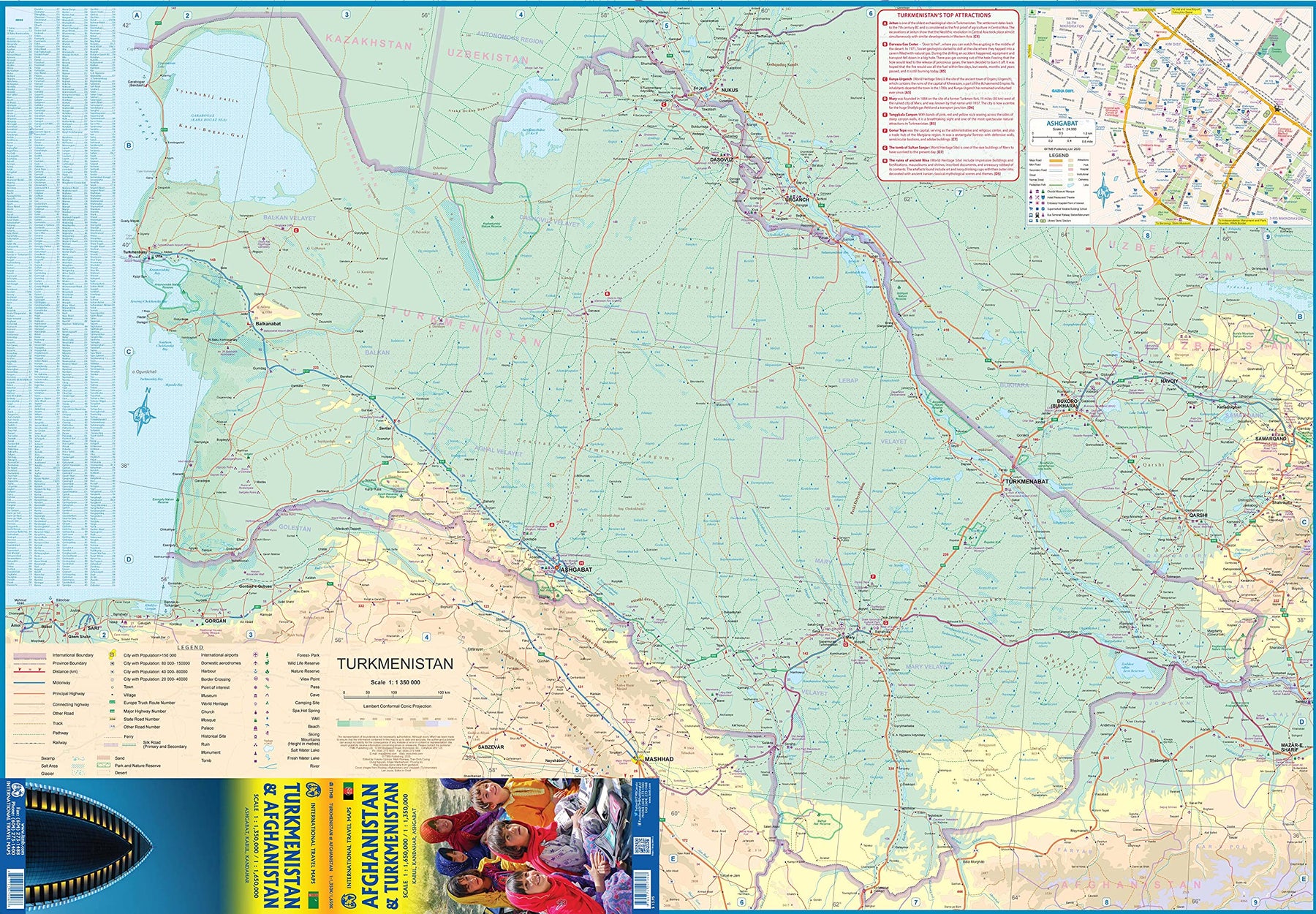
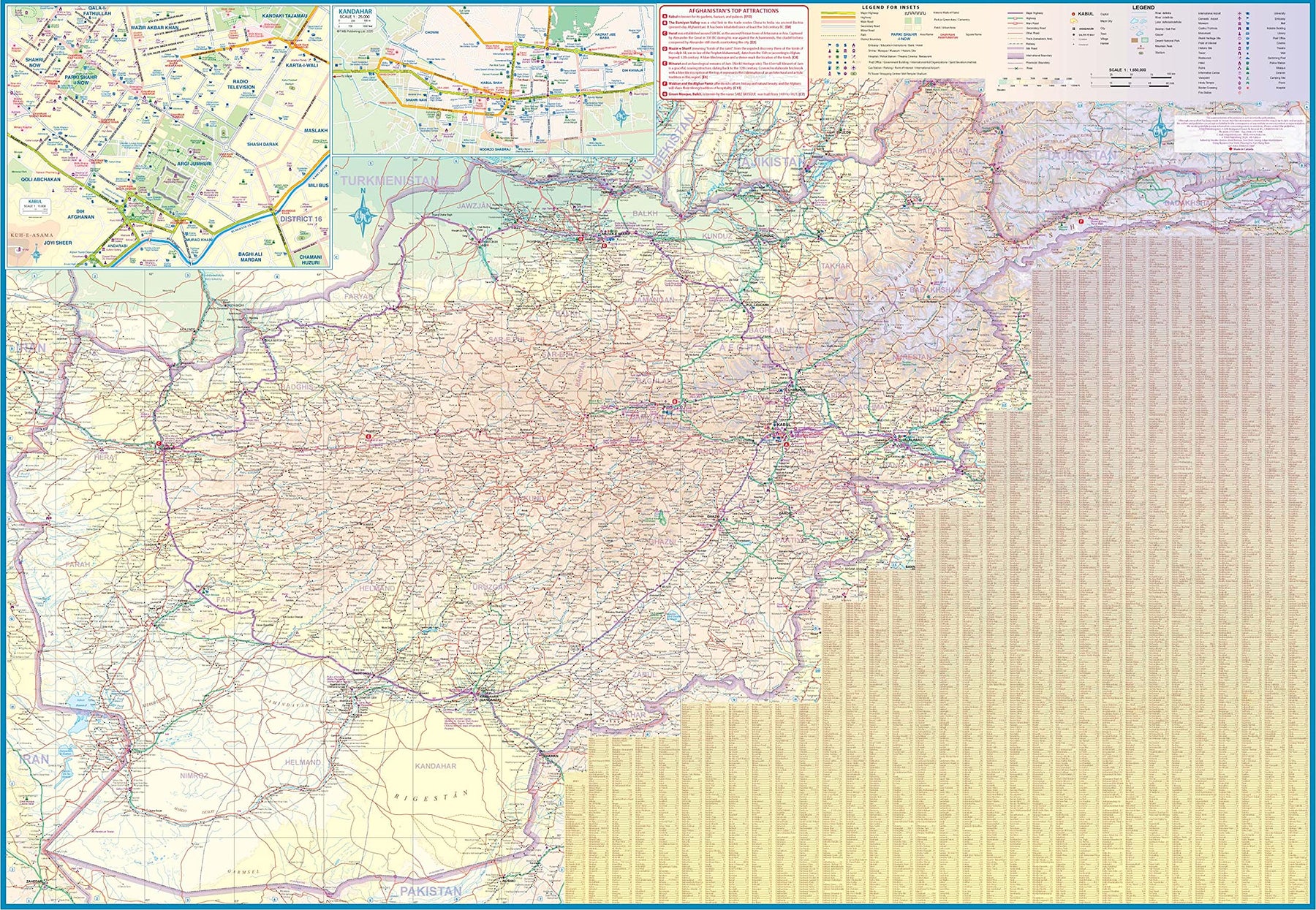
Turkmenistan & Afghanistan
Ordinær pris 179,00 kr/
Mva inkludert
Frakt beregnes i kassen.
The world is changing as a result of a global pandemic, and ITMB has to change with it. We wish to keep all of our artwork available, but at a time of greatly reduced travel, we have been forced to combine two different countries that share a common border in order to justify printing either one. The two countries, Afghanistan and Turkmenistan, do share a common heritage, but a very different history. ITMB Publishes a separate map of the country, and a map of Kabul. The reason for this map is that it is our first ever map of just Turkmenistan, a former part of the USSR that broke away in the collapse of the Russian empire in 1990. The country has, however, not emerged from the Soviet way of thinking, and is authoritarian in its attitude. It is, fortunately, open to travel, and is slowly improving its facilities, so is to be encouraged.
The map includes a very good inset map of Ashgabat, the capital. The country stretches from the Caspian Sea to the Uzbek border and from Russia south to Iran and Afghanistan. We have also added eight Top Attractions, ranging from the World Heritage site of Konye to the ancient ruins of Nisa. We previously published this titles as part of a regional map of the ‘Stans’, but growing demand has justified its own map. We have also published a separate map of Uzbekistan and a separate three-country map of the other three countries, all of which are showing strong signs of touristic development. Turkmenistan is a country emerging as a future travel Mecca. Legend Includes: Roads by classification, Rivers and Lakes, National Park, Airports, Points of Interests, Highways, Main Roads, Zoos, Fishing, and much more...
- Publisert: Aug. 2021
- Innbinding: Falset
- Materiale: Vanntett papir
- Målestokk: 1:1 350 000, 1:650 000

Iraq & Kuwait
Ordinær pris 169,00 kr/
Mva inkludert
Frakt beregnes i kassen.
Tysk kartserie med flotte kart på slitesterkt plastpapir.
Our maps combine state-of-the-art, GPS-compatible cartography (including hypsometric tints and contour lines) with a detailed rendering of road networks and touristic information. They offer the best possible scale, level of detail and readability, be it a map of a small island or half a continent.
The maps feature a detachable paper sleeve so that the maps can be folded easily and fit in every pocket. Although printed on plastic, a special coating makes sure the maps retain a paper-like feel and can even be written on with a pencil.
Publisert år: 2016
Innbinding: falset
Material: Plastpapir
Målestokk: 1:850,000

Around Manaslu & Tsum Valley
Ordinær pris 249,00 kr/
Mva inkludert
Frakt beregnes i kassen.
This 1:125,000 scale trekking map covers the Manaslu and Tsum Valley High Route circuit in the region between the Annapurna Conservation Area and the Langtang National Park.
- Publisert: Desember 2022
- Innbinding: Falset
- Materiale: Papir
- Målestokk: 1:125 000

Tsum Valley
Ordinær pris 199,00 kr/
Mva inkludert
Frakt beregnes i kassen.
Tsum Valley in central Nepal on an indexed contoured map at 1:100,000 from Shangri-La Design highlighting local trekking routes and places of interest, etc. Coverage extends roughly from the Budhi Gandaki River in the west across the eastern part of the Manaslu Conservation area, to just beyond Dunche in the east.
Topography is shown by contours at 40m intervals, plus colouring for woodlands, cultivated areas, glaciers, etc. The map shows local roads and distinguished between main trekking routes and minor trails. An overprint indicates various facilities in local villages, campsites, monasteries and other religious buildings, etc. The map is indexed for places, peaks and passes and had latitude and longitude margin ticks at 5’ intervals. Map legend includes English.
Addition information provided on the map or on its cover includes a table with relative oxygen rates at different altitudes, elevation profiles and hiking times for three main routes, plus general information about the area. All the text is in English.
Publisert år: 2009
Innbinding: falset
Material: papir
Målestokk: 1:100.000

Around Annapurna - Marsyangdi; Throng Pass; Kali Gandaki
Ordinær pris 249,00 kr/
Mva inkludert
Frakt beregnes i kassen.
A detailed map covering the Annapurna region, with a scale of 1:125,000. The map covers areas from 800m-5500m above sea level and includes a suggest circuit which you can alter to take between 9-21 days. The route goes from Besa Sahar, Chame, Manang, Ledar, Thorung La, Muktinath, Tatopani, Beni, Pokhara.
- Publisert: November 2022
- Innbinding: Falset
- Materiale: Papir
- Målestokk: 1:125 000


5 Shorong / Hinku
Ordinær pris 179,00 kr/
Mva inkludert
Frakt beregnes i kassen.
Shorong - Hinku region of Nepal at 1:50,000 on a waterproof and tear-resistant map in the famous Schneider series, revised in 2013 to include extensive tourist information for trekking routes in the area directly south of the Sagarmatha National Park. Centered on Lukla, coverage extends north to Namche Bazaar and south just beyond Kharikhola and the central part the Jiri to Mount Everest trail. Also highlighted is the trail via Kote to the Mera Peak Base Camp and High Camp.
Topography is very vividly presented by contours at 40m intervals, enhanced by excellent relief shading and numerous spot heights, plus colouring and/or graphics to show different types of the terrain (glaciers, crevasses, moraine, scree, etc) and vegetation. Highlighting for trekking trails distinguishes between main and secondary routes, and other local routes are marked. A very wide range of symbols indicate various accommodation options, locations with markets or food shops, banks, medical facilities, monasteries and other places of interest, access by air transport, etc. The map has a 2-km UTM grid, plus latitude and longitude margin ticks at 5’ intervals. Map legend is in German and English.
Publisert år: 2013 - Still current map of this region available as of May 2023
Innbinding: falset
Material: Vanntett papir
Målestokk: 1:50000

Myanmar (Burma)
Ordinær pris 149,00 kr/
Mva inkludert
Frakt beregnes i kassen.
Nelles dekker store deler av kloden og er spesielt gode på den ikke-vestlige verden. Bykart er innsatt i regionskartene, og du får avstandstabeller og avmerkede attraksjoner som for eksempel nasjonalparker.
Publisert år: 2019
Innbinding: falset
Material: Plastpapir
Målestokk: 1:1500000

China Central
Ordinær pris 129,00 kr/
Mva inkludert
Frakt beregnes i kassen.
Publisert år: 2019
Innbinding: falset
Material: papir
Målestokk: 1:1750000
Innbinding: falset
Material: papir
Målestokk: 1:1750000

Azerbaijan
Ordinær pris 169,00 kr/
Mva inkludert
Frakt beregnes i kassen.
Azerbaijan at 1:400,000 on a light, waterproof and tear-resistant, double-sided indexed map from Reise-Know-How. The map covers Azerbaijan and its Nakhchivan enclave; the armistice boundary of Nagorno-Karabakh is clearly marked, indicating open or closed border crossings, and where appropriate both Azeri and Armenian names of location are shown. Coverage includes eastern Armenia and south-eastern Georgia with Tbilisi.
Topography is presented by altitude colouring with spot heights and names of mountain ranges, peaks, passes, etc, plus boundaries of national parks and other protected areas. Road network includes selected unsurfaced local roads and tracks, and indicates driving distances on main routes. Railway lines are included and local airfields are marked. Internal administrative boundaries are presented with names of the provinces. Symbols highlight various places of interest, including locations with tourist accommodation, cultural heritage, beaches, etc. Also marked are oil wells and pipelines. Longitude and longitude lines are drawn at 30’ intervals. Map legend includes English.
- Publisert: 2016
- Innbinding: Falset
- Materiale: Plastpapir
- Målestokk: 1:275 000

Myanmar (Burma)
Ordinær pris 169,00 kr/
Mva inkludert
Frakt beregnes i kassen.
Tysk kartserie med flotte kart på slitesterkt plastpapir.
Myanmar / Burma at 1:1,500,000 on an indexed, waterproof and tear-resistant road map with topographic and tourist information, published by Reise Know-How as part of their highly acclaimed World Mapping Project. The map is double-sided to provide the best balance between a good scale and a convenient size sheet, with a very generous overlap between the two sides. Coverage on the southern side extends east to Bangkok and south to Ko Samui and Surat Thani, indicating border crossings to Thailand.
Road and rail networks are easy to see on a clear base which presents topography by light altitude colouring with contours, spot heights, mountain passes and names of mountain ranges. Road network includes selected local tracks and gives driving distances on main roads. Internal administrative boundaries are shown with names of the provinces. National parks and protected areas are marked and symbols highlight various places of interest, including UNESCO world heritage sites, archaeological remains, temples and museums, viewpoints, beaches, etc. The map also shows old versions of many town names (Sittwe / Akyab, Bago / Pegu, Pyay / Prome, etc. Latitude and longitude lines are at intervals of 1º. Extensive index of localities also includes names of national parks, places of interest, etc. Map legend includes English.
Publisert år: 2017
Innbinding: falset
Material: plastpapir
Målestokk: 1:1500000

Indonesia: Sumatra
Ordinær pris 259,00 kr/
Mva inkludert
Frakt beregnes i kassen.
Sumatra at 1:1,100,000 on light, waterproof and tear-resistant plastic paper, with both topographic and tourist information. The map, part of Reise Know-How's highly acclaimed "World Mapping Project", is double-sided to provide the best balance between a good scale and a convenient size sheet. Coverage includes Bangka and Belitung Islands, plus Riau and Lingga Archipelagoes shown as an inset at the same scale.
Topography is shown by altitude colouring with spot heights and graphics indicating salt flats. Detailed presentation of the road network includes dirt roads and local tracks; railways, local airports and ferry connections to other islands of the Indonesian archipelago are also shown. Local administrative units are shown with their boundaries and names. National parks and other protected areas are highlighted. A wide range of symbols shows various places of interest including UNESCO sites, temples, museums and monuments, hot springs and other natural features, etc. Latitude and longitude lines are drawn at 30’ intervals. The map has an extensive index of localities. Map legend includes English.
- Publisert: Juli 2024
- Innbinding: Falset
- Materiale: Plastpapir
- Målestokk: 1:1 100 000

745 Africa: North East & Arabia
Ordinær pris 169,00 kr/
Mva inkludert
Frakt beregnes i kassen.
Michelin er en av verdens beste, og best kjente, kartserier. Kartene har glimrende kartografi. Rød serie, kalt “national”. Dekker et enkelt land eller en gruppe land primært med hovedferdselsårer.
Publisert år: 2019
Innbinding: falset
Material: papir
Målestokk: 1:4000000

Hong Kong
Ordinær pris 99,00 kr/
Mva inkludert
Frakt beregnes i kassen.
Kart i postkortstørrelse. Folder seg ut som en popoutbok når du åpner dem. Fargerik turistinformasjon med kart over metro og busstraseer, landemerker og lignende. Veldig enkel å håndtere.
Publisert: Des. 2018
Innbinding: pop
Material: papp, papir

Beijing
Ordinær pris 119,00 kr/
Mva inkludert
Frakt beregnes i kassen.
Lonely Planet City Map er slitesterkt og vanntett, med en hendig slipcase og et format som er lett å brette. Få mer ut av kartet og reisen din med bilder og informasjon om byattraksjoner, transportkart, reiseruteforslag, omfattende gate- og nettstedsindeks og praktiske reisetips. Med dette brukervennlige navigasjonsverktøyet i baklommen kan du virkelig komme til hjertet av din destinasjon!
- Publisert: Sep, 2017
- Utgave: 1.utg
- Innbinding: Falset
- Material: Plastpapir

Singapore
Ordinær pris 119,00 kr/
Mva inkludert
Frakt beregnes i kassen.
Lonely Planet City Map er slitesterkt og vanntett, med en hendig slipcase og et format som er lett å brette. Få mer ut av kartet og reisen din med bilder og informasjon om byattraksjoner, transportkart, reiseruteforslag, omfattende gate- og nettstedsindeks og praktiske reisetips. Med dette brukervennlige navigasjonsverktøyet i baklommen kan du virkelig komme til hjertet av din destinasjon!
- Publisert: Jan, 2024
- Utgave: 2.utg
- Innbinding: Falset
- Material: Plast papir
- ISBN: 9781787016491

Shanghai
Ordinær pris 119,00 kr/
Mva inkludert
Frakt beregnes i kassen.
Lonely Planet City Map er slitesterkt og vanntett, med en hendig slipcase og et format som er lett å brette. Få mer ut av kartet og reisen din med bilder og informasjon om byattraksjoner, transportkart, reiseruteforslag, omfattende gate- og nettstedsindeks og praktiske reisetips. Med dette brukervennlige navigasjonsverktøyet i baklommen kan du virkelig komme til hjertet av din destinasjon!
- Publisert: Jan, 2017
- Utgave: 1.utg
- Innbinding: Falset
- Material: Plast papir

Hong Kong
Ordinær pris 119,00 kr/
Mva inkludert
Frakt beregnes i kassen.
Lonely Planet City Map er slitesterkt og vanntett, med en hendig slipcase og et format som er lett å brette. Få mer ut av kartet og reisen din med bilder og informasjon om byattraksjoner, transportkart, reiseruteforslag, omfattende gate- og nettstedsindeks og praktiske reisetips. Med dette brukervennlige navigasjonsverktøyet i baklommen kan du virkelig komme til hjertet av din destinasjon!
- Publisert: Desember 2024
- Utgave: 2. utgave
- Innbinding: Falset
- Materiale: Vannfast papir
- ISBN: 9781787015777