Filter
- AA Publishing
- Bradt
- Calazo
- Cappelen Damm
- Cicerone
- Discovery Walking Guides
- Editorial Alpina
- Esterbauer Verlag
- Eyewitness
- Freytag & Berndt
- Insight Guides
- ITM
- Lonely Planet
- Nordeca
- Ordnance Survey
- PopOut
- Reise Know-How
- Rother Walking Guide
- Rough Guides
- The Urban Explorer
- Touring Club Italiano
- Trailblazer
- Albania
- Andorra
- Belgia
- Bosnia-Hercegovina
- Bulgaria
- Danmark
- Eritrea
- Estland
- Finland
- Frankrike
- Hellas
- Hviterussland
- Irak
- Iran
- Irland
- Island
- Italia
- Kosovo
- Kroatia
- Kypros
- Latvia
- Litauen
- Luxembourg
- Malta
- Moldova
- Monaco
- Montenegro
- Nederland
- Nord-Makedonia
- Norge
- Polen
- Portugal
- Romania
- Russland
- Serbia
- Slovakia
- Slovenia
- Spania
- Storbritannia
- Sveits
- Sverige
- Tsjekkia
- Tyrkia
- Tyskland
- Ukraina
- Ungarn
- Østerrike
1353 produkter
1353 produkter
Utsolgt
707 France: North-East
169,00 kr

Lonely Planet Dutch Phrasebook & Dictionary
Ordinær pris 99,00 kr/
Mva inkludert
Frakt beregnes i kassen.
Lonely Planet Dutch Phrasebook & Dictionary is your handy passport to culturally enriching travels with the most relevant and useful Dutch phrases and vocabulary for all your travel needs. Understand art and culture, and ask for directions with confidence - all with your trusted travel companion. With language tools in your back pocket, you can truly get to the heart of wherever you go, so begin your journey now! Get More From Your Trip with Easy-to-Find Phrases for Every Travel Situation! Order with confidence, explain food allergies, and try new foods with the menu decoder. Save time and hassles with vital phrases at your fingertips. Never get stuck for words with the 3500-word two-way, quick-reference dictionary. Be prepared for both common and emergency travel situations with practical phrases and terminology. Meet friends with conversation starter phrases. Get your message across with easy-to-use pronunciation guides Inside Lonely Planet Dutch Phrasebook & Dictionary: Full-colour throughout. User-friendly layout organised by travel scenario categories. Survival phrases inside front cover for at-a-glance on-the-fly cues. Covers Basics - time, dates, numbers, amounts, pronunciation, reading tips, grammar rules. Practical - travel with kids, disabled travellers, senior travellers, sightseeing, business, banking, post office, internet, phones, repairs, shopping, bargaining, accommodations, directions, border crossing, transport. Social - meeting people, interests, feelings, opinions, going out, romance, culture, activities, weather. Safe Travel - emergencies, police, doctor, chemist, dentist, symptoms, conditionsFood - ordering, at the market, at the bar, dishes, ingredients The Perfect Choice: Lonely Planet Dutch Phrasebook & Dictionary, a pocket-sized comprehensive language guide, provides on-the-go language assistance.
forfattere: Regis st louis
Publisert måned: Mai
Publisert år: 2020
Utgave: 3.utg
Sider nr: 255

My Family and Other Enemies
Ordinær pris 229,00 kr Salgspris 199,00 kr Spar 13%/
Mva inkludert
Frakt beregnes i kassen.
My Family and Other Enemies is part travelogue, part memoir that dives into the hinterland of Croatia. Mary Novakovich explores her ongoing relationship with the region of Lika in central Croatia, where her parents were born.. 'Lika is little known to most travellers - apart from Plitvice Lakes National Park and the birthplace of Nikola Tesla' she says.
'It's a region of wild beauty that has been battered by centuries of conflict. Used as a buffer zone between the Habsburg and Ottoman empires for hundreds of years, Lika became a land of war and warriors. And when Yugoslavia started to disintegrate in 1991, it was here where some of the first shots were fired.'Shipped off to Lika as a child during the supposedly golden years of Tito to stay with relatives she barely knew, Novakovich has been revisiting Croatia ever since, researching the story of her family's often harrowing life: in 1941 her aunt was the only survivor of Serbs massacred by Croatian fascists; and her mother saved her grandmother from being buried alive when she was thought to be dead from typhus.
Amidst adversity there is resilience and laughter, too, with plenty of light to balance the shade. Eccentric and entertaining characters abound, showing typically sardonic Balkan humour. And, this being the Balkans, much of daily life revolves around food, which features prominently.
Forfattere: Mary Novakovich
Publisert måned: Aug
Publisert år: 2022
Utgave: 1.utg
Sider nr: 272

Slovak republic
Ordinær pris 169,00 kr/
Mva inkludert
Frakt beregnes i kassen.
Marco polo er svært detajerte kart som er praktiske og enkle i bruk. 7 klistremerker for å markere spesifikke steder gjør det enda enklere å planlegge reisen. Alle kartene inneholder en omfattende index for enkelt å finne frem.
Let the Marco Polo Slovak Republic Road Map guide you around this stunning country. Discover picturesque towns, glorious mountains and distinctive castles with this highly durable, detailed touring map of Slovakia. It folds away easily and is always on standby to help when you're stuck.
Perfect touring map - the scale is 1 : 300 000 ideal to help you tour the country by car or campervanEasy to use - the superbly clear mapping in strong colours and easy to read text will help you navigate the country like a localDurable, tear-resistant map - designed to withstand the rigors of the road, the map is printed on tear-resistant, water repellent and writeable paperHighlights included - major sights and key points of interest are marked on the map by numbered stars. Further information about these key sights can be downloaded via a QR code where you'll find a brief description to help you pick the best places to see en-routeDream routes - inspirational routes with beautiful scenery are included on the maps to guide you on your next adventureExtensive index - the thorough index, also included on the QR code, is fully cross-referenced to the map to help you pinpoint your destination quicklyFor the big trips and the little detours, trust Marco Polo's clear mapping and thorough index to guide you around Slovak Republic.Publisert år: 2017
Innbinding: falset
Material: papir
Målestokk: 1:300000
Utgitt: 2023


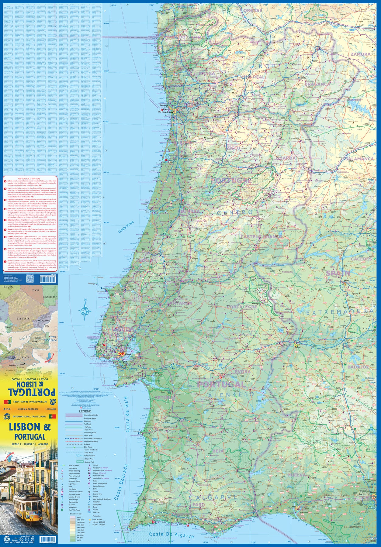
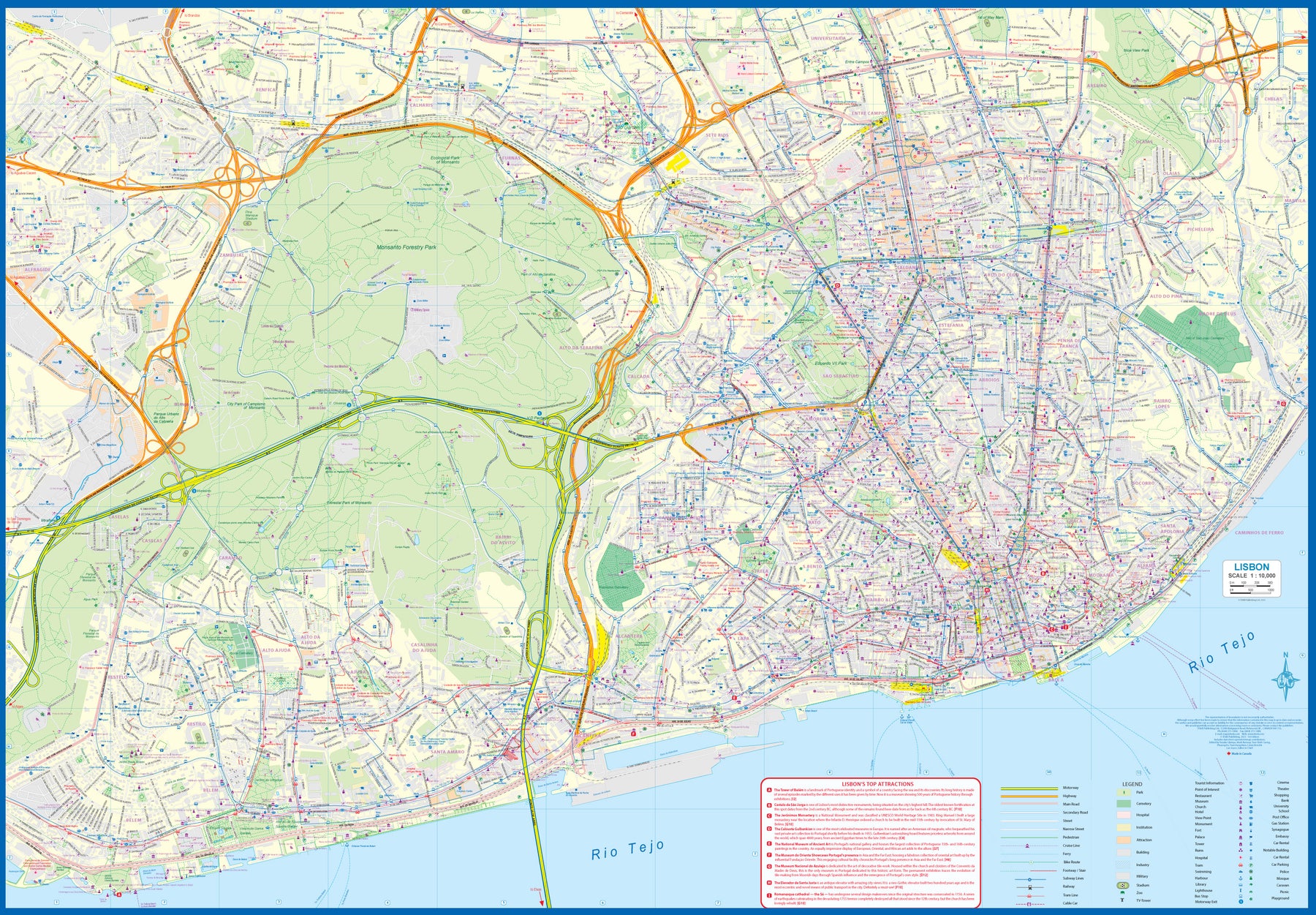
Portugal: Lisbon & Portugal
Ordinær pris 199,00 kr/
Mva inkludert
Frakt beregnes i kassen.
The city of Lisbon is one of the most attractive in Europe. It is an ancient city, but most of its architecture dates from the Victorian era. It has a fascinating number of tram lines, and the trams tend to be an experience worth the trip. One graces our cover. There is no cheaper way to explore this city than to climb aboard and let the rails decide your destination!
Coverage extends from the northern and western motorways to the southerly Rio Tejo and the national museum, so shows the city quite comprehensively. Almost half of the map area is of the massive Monsanto Park, one of the largest urban parks in the world. The reverse side is equally important, in that it presents our first-ever map dedicated to showing the charms of the entire country of Portugal. A bit of western Spain is included due to the unevenness of the border, but the map goes from the northernmost tipoff Castelo to the southernmost expanse of the Costa Do Algarve, showing touristic attractions, historic sites, beaches, museums, rail connections, and major parks.
The map is printed on waterproof stone paper, a recent technological innovation that is gradually replacing plastic.
- Publisert: 2023
- Innbinding: Falset
- Materiale: Vannfast papir
- Målestokk: 1:10 000, 1:600 000

Mediterranean Cruising
Ordinær pris 199,00 kr/
Mva inkludert
Frakt beregnes i kassen.
ITM har kart over hele verden og de spesialiserer seg på land litt utenfor allfarvei. Beliggenheten til landets nasjonalparker, historiske monumenter, de viktigste veiene o.L. Finner du inkludert i kartene. Samtlige landkart har ofte et bykart over hovedstaden.
Fra ITM: We are very pleased to present our very first cruising map covering the Mediterranean Sea. This is a double-sided map covering the eastern portion on side 1 and the western part on side 2. We were presented with a dilemma in designing this map, in that the shape of the sea is such that to include the straits of Gibraltar and the Dardanelles on the same map, a compromise would be necessary.
As few cruise ships now go to the North African coast, we concentrated on showing only the portion from Morocco to Tunisia so we could show Spain, France, Italy, Greece, the Balkans, and the Eastern Mediterranean, including the Black Sea. Little did we know that war in Europe would impact so intensely on what should be a pleasurable touristic map. Regardless, almost all of the ports of call for cruise ships in 2022 are shown on this map, including those favoured by smaller liners in the Adriatic Sea. We have also included common ferry routes between Italy and Greece and Marseille to Algiers.
- Publisert: 2022
- Innbinding: Falset
- Materiale: Papir
- Målestokk: 1:2 200 000

Great Britain and Ireland
Ordinær pris 199,00 kr/
Mva inkludert
Frakt beregnes i kassen.
- Publisert: 2024
- Innbinding: Falset
- Materiale: Plastlaminert papir
- Målestokk: 1:950 000

133 Zoom - Basque Coast South Landes
Ordinær pris 169,00 kr/
Mva inkludert
Frakt beregnes i kassen.
The MICHELIN zoom map Basque Coast is the ideal travel companion to fully explore this French tourist destination thanks to its easy-to-use format and its scale of 1/150,000. The map covers the areas and cities of San Sebastian, Mont de Marsan, Biarritz, Bayonne. From the hills and valleys of the Pays Basque and the Pyrenees Mountains to the vast forests of the Landes and the beaches that stretch for miles and miles on the Atlantic coast.
From towns like Bayonne, Biarritz, Saint Jean de Luz or Hossegor to the smaller villages inland, a visit to this part of the world is an unforgettable experience. There are so many places to see and even more things to do. The climate is mild and sports and leisure activities like golf, tennis, horse riding, surfing, hiking or cycling can be practiced all year long in breath-taking surroundings.
The Zoom collection are characterized by the high precision of their detailed scale, specially adapted for very touristy areas or with a high density road network, including new developments and industrial areas. In addition to clarity, reliability and up-to-date information, all Michelin cartography features include a wealth of practical information: places and monuments of tourist interest, picturesque tours, areas for sports and leisure activities ... Useful plans of cities and a practical index of localities.
Also the maps contain places of interest and signposting of tracks for bicycles and green-ways. MICHELIN ZOOM MAPS are perfect to discover major tourist areas, with a high level of details in an easy to use format. They nicely complement our Michelin Guides and include: * Various leisure activities, such as water parks, tourist trains, horse racing, etc* Scenic routes and tourist sights crossed referenced with the famous Michelin's Green Guides* Camping sites information from Michelin's Camping Guides* Hotel information from the world famous MICHELIN Guides
- Publisert: 2018
- Innbinding: Falset
- Materiale: Papir
- Målestokk: 1:150 000

Lonely Planet Oxford & the Cotswolds
Ordinær pris 119,00 kr/
Mva inkludert
Frakt beregnes i kassen.
Lonely Planet Planning Map er slitesterkt og vanntett, med en hendig slipcase og et format som er enkelt å brette. Få mer ut av kartet og reisen din med bilder og informasjon om toppattraksjoner i landet, reiseruteforslag, en transportguide, planleggingsinformasjon, temalister og praktiske reisetips. Med dette brukervennlige navigasjonsverktøyet i baklommen kan du virkelig komme til hjertet av din destinasjon!
- Publisert: Juni, 2025
- Utgave: 2. utgave
- Innbinding: Falset
- Materiale: Plastpapir

Czechia
Ordinær pris 229,00 kr/
Mva inkludert
Frakt beregnes i kassen.
Reise Know-How maps (world mapping project series) are easy-to-read, waterproof and highly durable travel maps specifically designed for everyday use on the road.
The maps combine state-of-the-art, GPS-compatible cartography (including hypsometric tints and contour lines) with a detailed rendering of road networks and touristic information. They offer the best possible scale, level of detail and readability, be it a map of a small island or half a continent.
The maps feature a detachable paper sleeve so that the maps can be folded easily and fit in every pocket. Although printed on plastic, a special coating makes sure the maps retain a paper-like feel and can even be written on with a pencil.
- Publisert: 2024
- Innbinding: Falset
- Materiale: Plastpapir
- Målestokk: 1:350 000

Serbia
Ordinær pris 239,00 kr/
Mva inkludert
Frakt beregnes i kassen.
Gizi Map er en serie presise kart med detaljer og opplysninger over både populære og mindre populære reisemål. Dekker ofte områder der få andre kartprodusenter dekker.
- Publisert: 2020
- Innbinding: Falset
- Materiale: Papir
- Målestokk: 1:500 000

24 Södra Stockholm
Ordinær pris 189,00 kr/
Mva inkludert
Frakt beregnes i kassen.
- Publisert år: 2015
- Innbinding: Falset
- Materiale: Papir
- Målestokk: 1:50 000

015 Marmolada, Pelmo, Civetta, Moiazza
Ordinær pris 249,00 kr/
Mva inkludert
Frakt beregnes i kassen.
Forlaget Casa Editrice Tabacco har produsert geografiske kart siden slutten av krigen og merkevaren er internasjonalt anerkjent for presisjon og sikkerhet for ekstreme klatrere, fjellklatrere, fotturister, turgåere og helge turgåere.
- Publisert: 2022
- Innbinding: Falset
- Materiale: Papir
- Målestokk: 1:25 000


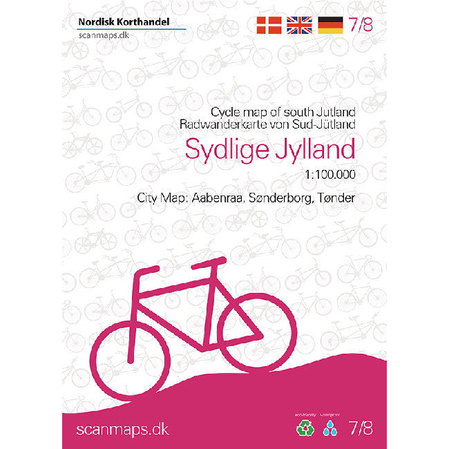
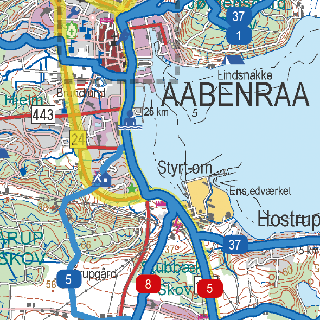
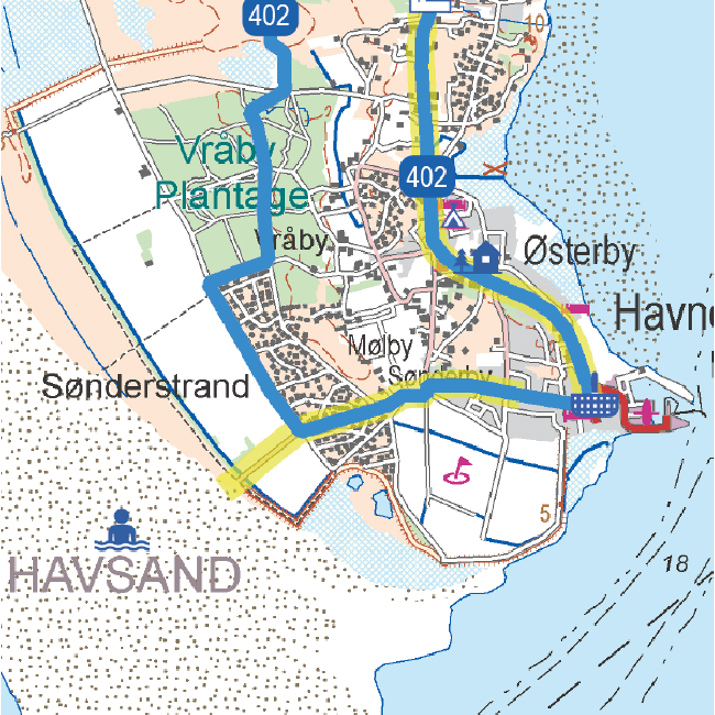
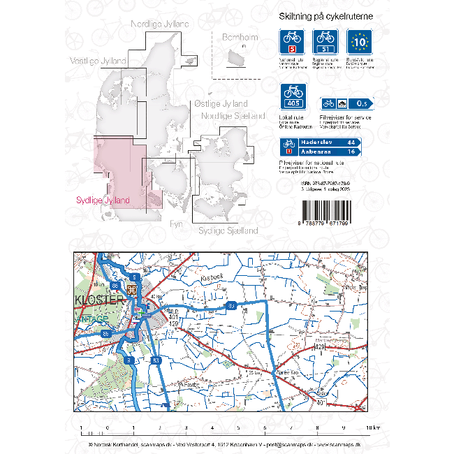
Sykkelkart 7 - Sydlige Jylland
Ordinær pris 249,00 kr/
Mva inkludert
Frakt beregnes i kassen.
- Publisert: 2023
- Innbinding: Falset
- Materiale: Plastpapir
- Målestokk: 1:100 000

Sierra Nevada - La Alpujarra Parque Nacional
Ordinær pris 249,00 kr/
Mva inkludert
Frakt beregnes i kassen.
- Publisert: 2024
- Innbinding: Falset
- Materiale: Papir
- Målestokk: 1:40 000

France: Brittany
Ordinær pris 199,00 kr/
Mva inkludert
Frakt beregnes i kassen.
Reise Know-How maps (world mapping project series) are easy-to-read, waterproof and highly durable travel maps specifically designed for everyday use on the road.
The maps combine state-of-the-art, GPS-compatible cartography (including hypsometric tints and contour lines) with a detailed rendering of road networks and touristic information. They offer the best possible scale, level of detail and readability, be it a map of a small island or half a continent.
The maps feature a detachable paper sleeve so that the maps can be folded easily and fit in every pocket. Although printed on plastic, a special coating makes sure the maps retain a paper-like feel and can even be written on with a pencil.
- Publisert: 2024
- Innbinding: Falset
- Materiale: Plastpapir
- Målestokk: 1:200 000

Greece: Corfu
Ordinær pris 169,00 kr/
Mva inkludert
Frakt beregnes i kassen.
Tysk kartserie med flotte kart på slitesterkt plastpapir.
Reise Know-How maps (world mapping project series) are easy-to-read, waterproof and highly durable travel maps specifically designed for everyday use on the road.
The maps combine state-of-the-art, GPS-compatible cartography (including hypsometric tints and contour lines) with a detailed rendering of road networks and touristic information. They offer the best possible scale, level of detail and readability, be it a map of a small island or half a continent.
The maps feature a detachable paper sleeve so that the maps can be folded easily and fit in every pocket. Although printed on plastic, a special coating makes sure the maps retain a paper-like feel and can even be written on with a pencil.
- Publisert: 2019
- Innbinding: Falset
- Materiale: Plastpapir
- Målestokk: 1:65 000

Croatia
Ordinær pris 199,00 kr/
Mva inkludert
Frakt beregnes i kassen.
Croatia on an indexed, double-sided map from Reise Know-How, printed on light, waterproof and tear-resistant synthetic paper. The country is shown on three panels designed to provide convenient coverage of its most visited part, the Adriatic Coast. The map, part of the publishers’ highly acclaimed World Mapping Project, presents the coastal regions of Croatia at 1:300,000 spread across both sides of the sheet, with a good overlap and the mapping tilted so that the coastline stretches horizontally. The inland part of Croatia is added as an inset at 1:700,000 – please see the coverage image.
Light altitude colouring with names of mountain ranges, peaks, etc, shows the topography; national parks and protected areas are highlighted. Road network, clearly visible against the background, includes local roads and selected tracks, and indicates routes closed to motorized traffic. Driving distances are marked on many smaller roads. Railway lines are shown with stations; ferry links along the Adriatic indicate approximate passage timings. Locations of particular interest are highlighted and symbols mark various other places of interest. Latitude and longitude lines are drawn at 15’ (300K) and 1° (700K) intervals. Map legend includes English.
- Publisert: 2023
- Innbinding: Falset
- Materiale: Vannfast papir
- Målestokk: 1:700 000

Sardinia
Ordinær pris 189,00 kr/
Mva inkludert
Frakt beregnes i kassen.
Marco polo er svært detajerte kart som er praktiske og enkle i bruk. 7 klistremerker for å markere spesifikke steder gjør det enda enklere å planlegge reisen. Alle kartene inneholder en omfattende index for enkelt å finne frem.
Fully updated, Marco Polo maps feature completely up-to-date, digitally generated mapping. The high quality cartography with distance indicators and scale converters aid route planning. Includes a city map of Cagliari. Major sights and key points of interest are marked on the map by numbered stars and these are listed in the index booklet with a brief description to help travellers pick the best places to see en route. Comprehensive index.
Publisert: 2024
Innbinding: falset
Material: papir
Målestokk: 1:200,000

Belgium & Luxembourg
Ordinær pris 189,00 kr/
Mva inkludert
Frakt beregnes i kassen.
Let the Marco Polo Belgium and Luxembourg Road Map guide you around these beautiful countries. Discover picturesque towns, distinctive castles, Flanders Fields and the smallest city in the world with this highly durable, detailed touring map of Belgium and Luxembourg. It folds away easily and is always on standby to help when you're stuck.
- Publisert: 2024
- Innbinding: Falset
- Materiale: Papir
- Målestokk: 1:250 000

Greece: Lesbos (lesvos)
Ordinær pris 189,00 kr Salgspris 94,50 kr Spar 50%/
Mva inkludert
Frakt beregnes i kassen.
Dette store østerriske kartforlaget er kjent for sin klare kartografi og gode papirkvalitet. De kommer i alle målestokker, og flere av landkartene inneholder bykart og turistinformasjon.
Lesbos at 1:50,000 on an indexed, GPS compatible map from Freytag & Berndt with brief descriptions of places of interest highlighted on the map, plus a street plan of Mitilini. The map is double-sided, dividing the island east/west, with a very generous overlap between the sides.
Topography of the island is shown by bold relief shading, enhanced by contours at 40m intervals. All place names are given in both Greek and Latin alphabet. Road network includes small local roads and selected cart tracks, showing driving distances on main and secondary routes. Ferry connections are marked.
The island’s best sights are prominently highlighted and provided with brief multilingual descriptions in a booklet attached to the map cover. Various other places of interest are marked and named on the map, including numerous beaches and churches/monasteries.
The map has a UTM grid, plus latitude and longitude margin ticks. The index, placed in the booklet, provides GPS waypoints for all the locations listed in it. Multilingual map legend includes English.
Publisert år: 2018
Innbinding: falset
Material: papir
Målestokk: 1:50000

Spain: La Palma
Ordinær pris 169,00 kr/
Mva inkludert
Frakt beregnes i kassen.
Dette store østerriske kartforlaget er kjent for sin klare kartografi og gode papirkvalitet. De kommer i alle målestokker, og flere av landkartene inneholder bykart og turistinformasjon.
Clear road map of La Palma from Freytag & Berndt showing its road network with main places of interest and hiking trails, plus street plans of Santa Cruz de la Palma, Los Cancajos, Puerto Naos and Los Llanos de Ariadne.
Publisert år: 2024
Innbinding: falset
Material: papir
Målestokk: 1:40000

335 Local: Gironde; Landes
Ordinær pris 169,00 kr/
Mva inkludert
Frakt beregnes i kassen.
Michelin er en av verdens beste, og best kjente, kartserier. Kartene har glimrende kartografi.
- Publisert: 2023
- Innbinding: Falset
- Materiale: Papir
- Målestokk: 1:150 000

725 France - Southern
Ordinær pris 169,00 kr/
Mva inkludert
Frakt beregnes i kassen.
Michelin er en av verdens beste, og best kjente, kartserier. Kartene har glimrende kartografi.
- Publisert: 2023
- Innbinding: Falset
- Materiale: Papir
- Målestokk: 1:1 000 000

724 France - Northern
Ordinær pris 169,00 kr/
Mva inkludert
Frakt beregnes i kassen.
Michelin er en av verdens beste, og best kjente, kartserier. Kartene har glimrende kartografi.
- Publisert: 2023
- Innbinding: Falset
- Materiale: Papir
- Målestokk: 1:1 000 000

552 Switzerland Southwest
Ordinær pris 169,00 kr/
Mva inkludert
Frakt beregnes i kassen.
Michelin er en av verdens beste, og best kjente, kartserier. Kartene har glimrende kartografi.
- Publisert: 2023
- Innbinding: Falset
- Materiale: Papir
- Målestokk: 1:200 000

532 Netherlands South
Ordinær pris 169,00 kr/
Mva inkludert
Frakt beregnes i kassen.
Michelin er en av verdens beste, og best kjente, kartserier. Kartene har glimrende kartografi.
- Publisert: 2023
- Innbinding: Falset
- Materiale: Papir
- Målestokk: 1:200 000

148 Zoom - Costa Daurada
Ordinær pris 169,00 kr/
Mva inkludert
Frakt beregnes i kassen.
Michelin er en av verdens beste, og best kjente, kartserier. Kartene har glimrende kartografi.
MICHELIN zoom map Costa Daurada is the ideal travel companion to fully explore the Spanish Gold Coast, thanks to its easy-to-use format and its scale of 1/150,000. In addition to Michelin's clear and accurate mapping, MICHELIN Zoom map highlights all the leisure activities available, such as golf clubs and tourist trains. MICHELIN Zoom Maps also include star-rated scenic routes, tourist sights & attractions, as well as camping sites and hotels selected in the famous MICHELIN guides. Make the most of your stay with MICHELIN Zoom Maps! MICHELIN ZOOM MAPS are perfect to discover major tourist areas, with a high level of details in an easy to use format. They nicely complement our Michelin Guides and include: - Various leisure activities, such as water parks, tourist trains, horse racing, etc - Scenic routes and tourist sights crossed referenced with the famous Michelin's Green Guides - Camping sites information from Michelin's Camping Guides - Hotel information from the world famous MICHELIN Guides.
Publisert år: 2023
Innbinding: falset
Material: papir
Målestokk: 1:150000