Filter
- Albania
- Angola
- Argentina
- Armenia
- Aserbajdsjan
- Australia
- Bahamas
- Bahrain
- Belgia
- Benin
- Bolivia
- Bosnia-Hercegovina
- Brasil
- Brunei
- Bulgaria
- Burundi
- Canada
- Chile
- Costa Rica
- Djibouti
- Dominica
- Egypt
- El Salvador
- Eritrea
- Estland
- Eswatini
- Etiopia
- Fiji
- Frankrike
- Georgia
- Hellas
- Honduras
- Hviterussland
- India
- Indonesia
- Irak
- Italia
- Jamaica
- Japan
- Kambodsja
- Kina
- Kongo
- Kosovo
- Kroatia
- Latvia
- Lesotho
- Liechtenstein
- Litauen
- Luxembourg
- Malaysia
- Mali
- Mauritania
- Mexico
- Mongolia
- Montenegro
- Nederland
- New Zealand
- Nicaragua
- Niger
- Nigeria
- Nord-Makedonia
- Norge
- Oman
- Panama
- Paraguay
- Polen
- Portugal
- Romania
- Russland
- Rwanda
- Samoa
- Serbia
- Sierra Leone
- Slovakia
- Slovenia
- Solomonøyene
- Spania
- Sri Lanka
- Storbritannia
- Sveits
- Taiwan
- Togo
- Tonga
- Tsjekkia
- Tyskland
- Ukraina
- Ungarn
- USA
- Vanuatu
- Venezuela
- Vietnam
- Østerrike
114 produkter
114 produkter
Utsolgt
Sri Lanka & India South
199,00 kr
Utsolgt
Spain
199,00 kr


Europe Eastern: Railway & Road
Ordinær pris 199,00 kr/
Mva inkludert
Frakt beregnes i kassen.
Europe may be small in comparison to Canada, but it is densely populated and difficult to map as a continent while providing detail. Eastern Europe used to be defined as everything behind the Iron Curtain during the Cold War, but now it encompasses everything east of Germany and Switzerland, which means that this map covers Italy, Greece and the Balkan countries, the Central European countries of Romania and Hungary and most of Ukraine, Poland and the three Baltic states, and western Russia as far east as Volgograd, as well as much of Turkey. It is a combined road and rail map, showing motorways and major highways, fast-train routes in red and regular services in black. It also shows major cruise line routes, although many have been suspended due to Covid and political situations in Russia and Turkey.
Essentially, this is a map covering a very large area, as are our maps of Western and Central Europe, and our earlier map of Scandinavia. We have tried to make it politically correct, which is difficult considering the Russian occupation of Crimea and the Donetsk region of Ukraine and the on-going controversy over the ‘proper’ name for Macedonia, so we apologize for any errors. For simplicity’s sake, we have named most place names in English, so Roma is Rome and Moscva is Moscow etc. Fortunately, most English place names are the same in the local languages. However, being ITMB, Naples is Napoli, and Florence is Firenze, so don’t be too critical of us; we’re trying to reconcile differing perspectives.
- Publisert: 2021
- Innbinding: Falset
- Materiale: Papir
- Målestokk: 1:2 600 000

Egypt & Cairo kart, ITM
Ordinær pris 239,00 kr/
Mva inkludert
Frakt beregnes i kassen.
2nd Edition Following the so-called Arab spring of a few years ago, northern Africa experienced much turbulence. Egypt experienced the overthrow of the government, the installation of a radical religious-oriented replacement, and the installation of a radical religious-oriented replacement, and the installation of military governance. Tourism plummeted. Most map publishers discontinued their maps of the country. Five years later, Egypt has stabilized and tourism is growing. We feel that the time is right to re-introduce our ITMB map of Egypt.
This version focuses on the portions of the country that have been re-opened for tourism, which means from the Mediterranean coastline south to the Aswan Dam. The portion further south remains closed for the moment, as is the border crossing with Sudan. We have also unrest, as the border areas with Libya remain very unstable. However, we have provided a large inset map of Egypt, covering everything, in the area of desert. We have also added a listing of Egypt's Top tombs.
The other side of the sheet is a detailed map of Cairo, with an inset of the Giza Pyramid complex just to the west of Cairo, and another inset of the Cairo region showing all the known tombs west of the Nile River south to Helwan. The back cover is a schematic map of the rapid transit system of Cairo. There is a third inset, showing Alexandra and other associated urban areas along the coast. The maps is printed on stone paper, which is waterproof, durable, and long-lasting. It is also biodegradable.
- Publisert: 2020
- Innbinding: Falset
- Material: Plastpapir
- Målestokk: 1:1 000 000, 1:12 500

Vietnam, Laos & Cambodia
Ordinær pris 199,00 kr/
Mva inkludert
Frakt beregnes i kassen.
The Indochinese Peninsula is one of the world's treasure troves of cultural diversity and historical activity. In the north are the hill tribes of Laos and Vietnam. Along the coast are the Viet people, and in the south the huge cultural area of Khmer influence - from Angkor Wat to the Cham ruins in the southeast of Vietnam. The Plain of Jars, in Laos remains one of the most intriguing puzzles of the modern world, and the temples of Louang Phabang are reknowned.
This map shows all of these wonders and many more. This is a very detailed map, prepared in the region, and showing just about anything a vistor would want in a map.
- Publisert: 2025
- Innbinding: Falset
- Materiale: Vannfast papir
- Målestokk: 1:1 230 000


Norway: Oslo, Bergen & South
Ordinær pris 199,00 kr/
Mva inkludert
Frakt beregnes i kassen.
This map represents a major step forward on coverage of southern Norway. The map is now on tear-resistant stone paper and places Oslo and Bergen on one side, allowing us to include a large-scale map of all of southern Norway as far north as Trondheim on the other side. This covers the portion of Norway most visited and includes all the best-known fiords. The back cover also shows a schematic rendition of the 6 metro lines in Oslo, plus the tram network and the commuter rail from the airport into the city.
- Publisert: 2023
- Innbinding: Falset
- Materiale: Papir
- Målestokk: 1:8 000, 1:800 000

Reisekart Caucasus, ITM
Ordinær pris 219,00 kr/
Mva inkludert
Frakt beregnes i kassen.
Veikart Kaukasus
Dobbeltsidig kart over Kaukasus-regionen med små planleggingskart over Jerevan, Baku og Tbilisi.
Grenseområdet som skiller Europa fra Asia består av Georgia, Armenia og Aserbajdsjan. Dette ekstremt detaljerte kartet vil være en utmerket guide for alle som besøker disse tre landene, og viser veier, byområder, fysiske trekk og turistattraksjoner.
Med små byplaner over Jerevan, Baku og Tbilisi.
2. utgave Indeksert, tosidig kart over Kaukasus-regionen fra ITMB med små planer over Jerevan, Baku og Tbilisi, trykt på slitesterkt vanntett papir. Relieffet er avbildet med høydetoning, med punkthøyder for utvalgte topper. Sumpområder, nasjonalparker og reservater er markert, og batymetrisk toning er brukt på havområdene. Georgia-målestokken er 1:430 000 og Aserbajdsjan/Georgia i 1:650 000.
- Publisert: 2020
- Innbinding: Falset
- Materiale: Papir
- Målestokk: 1:430 000, 1:650 000

France: South Rail & Bike
Ordinær pris 199,00 kr/
Mva inkludert
Frakt beregnes i kassen.
This is a brand new title for ITMB and an attempt to portray a changing travel landscape in a mapping format. Eco-tourism is a rapidly growing activity, with enormous potential. At the same time, governments are seeking to reduce carbon pollution by encouraging train travel, so ITMB is climbing aboard the movement by publishing a map encouraging train travel while still retaining the road network and noting all the long-distance bike routes in southern France by designated number.
This is, by its scale, a generalized map of that portion of France south of Poitiers or Lyon to the Mediterranean, so is more of a regional map showing biking opportunities than a detailed trail map. Nevertheless, it is an excellent map on waterproof paper showing cycling routes and tertiary roads that are suitable for recreational exploration. Naturally, motorways and main highways are shown as well. Legend Includes: Roads by classification, Rivers and Lakes, National Park, Airports, Points of Interests, Mining, Highways, Main Roads, Zoos, Fishing, , and much more...
- Publisert: 2020
- Vanntett materiale
- Målestokk: 1:600 000
- ISBN: 9781771292849


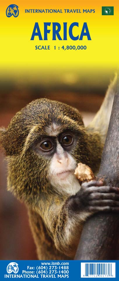

Africa
Ordinær pris 199,00 kr/
Mva inkludert
Frakt beregnes i kassen.
Africa is a huge continent. No one apart from us has successfully prepared a digital data base for the entire continent and this edition includes numerous updates to road information and shifting political realities. We have updated roads whenever reliable data indicates improvements, such as connections between the southern tip of Morocco and the road leading to Nouakchott, in Mauritania. Politically, we all know of things that do not affect maps - the closed border between Algeria and Morocco, the coup in Guinea, the continued instability of Libya, the generally better degree of stability in Somalia, the on-going troubles in South Sudan - but generally, the continent of 54 nation states and a few colonial enclaves has survived two years of destabilizing Covid ravages rather well. Tourism is gradually recovering, and map sales improving.
This is a very important map in that it brings all of the countries and islands relative to the African continent into perspective. We are pleased to bring to your attention an updated version of a part of the world that is crucially important.
- Publisert: 2022
- Innbinding: Falset
- Materiale: Papir
- Målestokk: 1:4 800 000


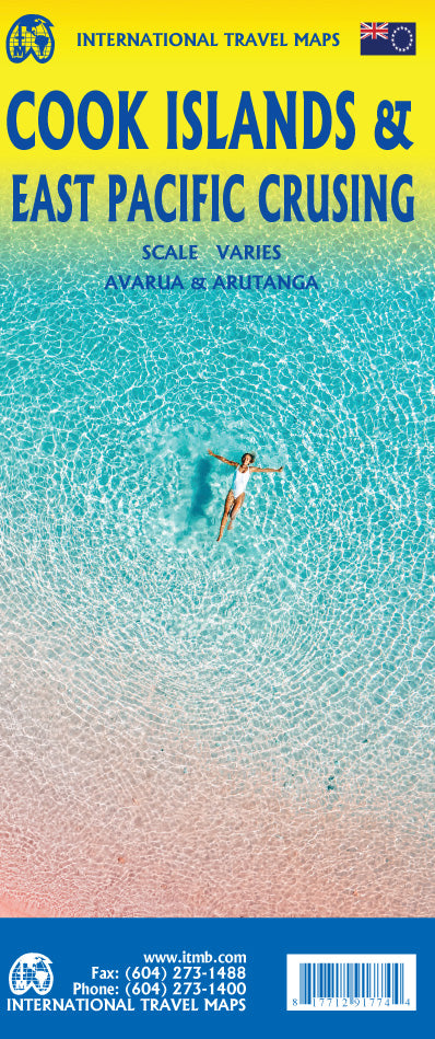
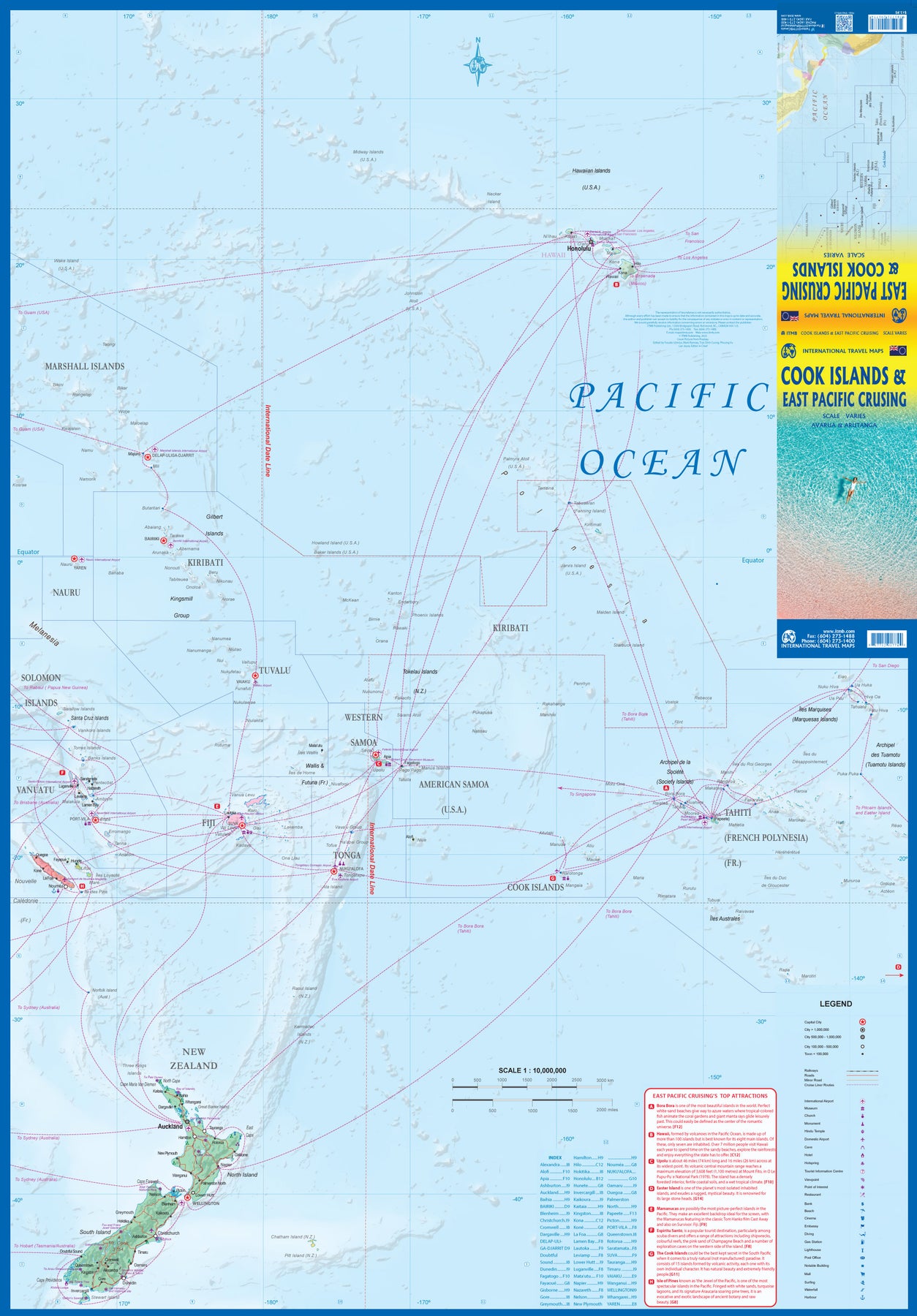
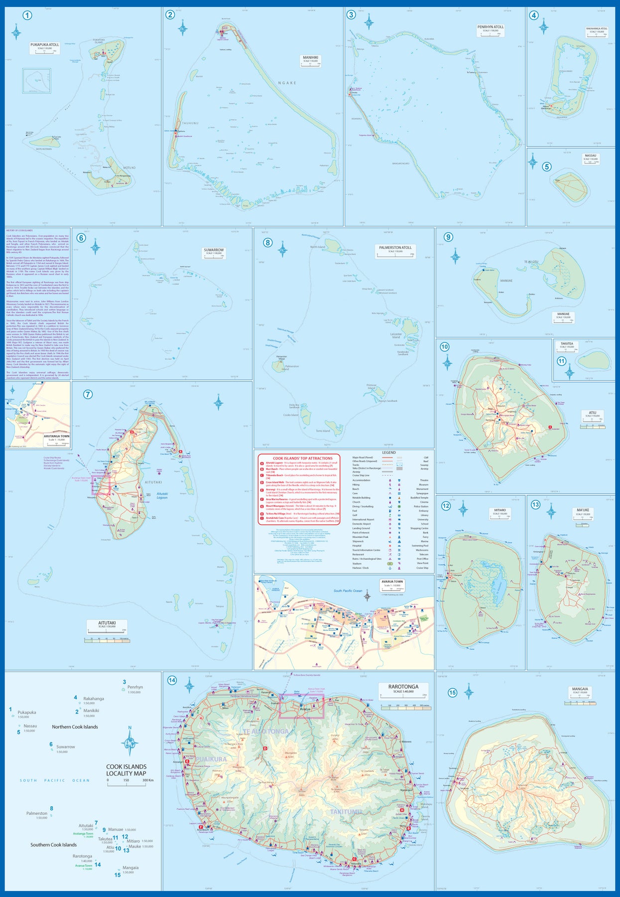
South Pacific: Cook Islands & East Pacific Cruising
Ordinær pris 199,00 kr/
Mva inkludert
Frakt beregnes i kassen.
This is a combination map, focused on two travel realities. Side 1 is a detailed map of the main islands making up the Cook Island archipelago. To provide more detail, the country is an inset map in the lower left corner, with numbers in blue, up to 15. The main map on Side 1 is a series of inset maps providing excellent detail of individual islands, such as Raratonga, Mangaia, or Aitutaki, or island groupings of more northerly groupings that are little more than atolls, such as Penrhyn or Palmerston. The capital is Avarua, and an inset map is included; also one of Arutanga on Aitutaki. The country is well-positioned for tourism, and has many resorts, particularly on Raratonga.
Side 2 is a new map for ITMB, part of our growing Cruising line. This on covers the eastern portion of the South Pacific, from the Marshall Islands, Nauru, and the Solomons on the west to Hawaii and Tahiti on the east, and as far south as New Zealand. Other island nations included on this map are Kiribati, Tuvalu, Fiji, Samoa, and New Caledonia. By the nature of portraying a vast ocean, little detail of each island can be provided. The purpose of this map is to show routes followed by ships visiting the overall region. This is a rapidly-growing travel area for major cruise lines, and promises to be as attractive in the future as cruises in the Caribbean or Mediterranean. This region holds great prospects for the future. Besides, it is a lovely map to look at.
- Publisert: 2022
- Innbinding: Falset
- Materiale: Papir
- Målestokk: Varierende

South Pacific: Cruising & Samoa
Ordinær pris 199,00 kr/
Mva inkludert
Frakt beregnes i kassen.
In conjunction with several cruise ship lines, ITM have prepared a map of the South Pacific Ocean, Which extends southwards from Hawai’i to the southern tip of New Zealand and eastwards from central Australia/Papua New Guinea to the Pitcairn Islands. Thus, it does not include the popular South East Asia and China coast routes. We think this has to change at a time when 25,000,000 people are travelling by cruise ships. At the same time, we must keep coverage area relevant for those end users of the artwork. Even at 1:12M, most of the area covered is water, with island countries such as Fiji, Tonga, Kiribati, Tahiti, and the Cook Islands being visible, but without detail.
For those readers more familiar with Caribbean or Mediterranean cruising, the reason for our focus on the South Pacific is due to the fact that this region of the world is the fastest-growing portion of cruise travel growth. The map of the South Pacific region fills one side of the map. The reverse side of the artwork covers the two entities known collectively as Samoa, which has been included for two reasons. First, it is in the centre of the South Pacific and several cruise companies stop at Pago Pago. Second, the two Samoas form a unit that is not contiguous with any other part of the vast Pacific region. Independent Western Samoa consists of two main islands and two small islands, which have been portrayed at 1:160,000 scale. An inset map of the capital, Apia is included.
- Publisert: 2019
- Innbinding: Falset
- Materiale: Papir
- Målestokk: Varierende

France: North Rail & Bike
Ordinær pris 199,00 kr/
Mva inkludert
Frakt beregnes i kassen.
The northern half of France is fairly flat, making it an ideal area for biking. However, it is also a rather large area, covering several provinces of France, so we have combine rail access with biking. All the motorways and main highways are also shown, so this map is ideal for someone wanting to drive to, say , Brittany, and bike during their stay in the Breton peninsula. Side 1 covers Normandy, Brittany, the Loire, and the Poitou region west of Paris. Side 2 covers all of northern France from Calais to Strasbourg and south to Lyon. Small adjacent portions of Switzerland and Italy are included. A Top 9 Attractions list is included. France South was published a little while ago, so the entire country is now available in detail. The map is printed on waterproof stone paper for durability.
- Publisert: 2021
- Innbinding: Falset
- Materiale: Vanntett papir
- Målestokk: 1:700 000

Panama
Ordinær pris 199,00 kr/
Mva inkludert
Frakt beregnes i kassen.
ITM har kart over hele verden og de spesialiserer seg på land litt utenfor allfarvei. Beliggenheten til landets nasjonalparker, historiske monumenter, de viktigste veiene o.L. Finner du inkludert i kartene. Samtlige landkart har ofte et bykart over hovedstaden.
Fra ITM: The Central American country of Panama is actually and east-west country, not a north-south one as one might expect. Its historic claim to fame is two-fold. It was here that Spanish conquistadors first set eyes on the vast Pacific Ocean, and it is here that much of the world's commercial goods pass from the Pacific to the Atlantic. The Canal is extremely important, and a "must see" attraction, but the country offers much more. Santa Catalina is a world-class surfing destination. The Pearl Islands feature virgin forest and pristine beaches. Boquette, in the northern mountains, is the valley of the flowers. Panama City is a vibrant economic centre for shopping. In recent years, Panama has invested heavily in tourism. The roads are excellent, the people are friendly, the restaurants are excellent, and the country is peaceful. Who could ask for more?
Inkl. bykart over Panama City
Publisert år: 2024
Innbinding: falset
Material: plastpapir
Målestokk: 1:400,000

Bolivia
Ordinær pris 199,00 kr/
Mva inkludert
Frakt beregnes i kassen.
ITM har kart over hele verden og de spesialiserer seg på land litt utenfor allfarvei. Beliggenheten til landets nasjonalparker, historiske monumenter, de viktigste veiene o.L. Finner du inkludert i kartene. Samtlige landkart har ofte et bykart over hovedstaden.
Fra ITM: 6th edition 2025. As a travel destination, Bolivia definitely ranks among the routes less travelled! However, it is a fascinating country and well-worth visiting. We have printed this edition on plasticized paper for durability, as one will definitely need a map to get around this mountainous country. The map shows the road network to best advantage, with distances between communities whenever possible Touristic sites are noted, and elevations, parks, and reserves. Inset maps of La Paz, Potosi, and Santa Cruz de la Sierra are included.
Publisert år: 2025
Innbinding: falset
Material: plastpapir
Målestokk: 1:1,400,000


Sierra Leone & Freetown
Ordinær pris 199,00 kr/
Mva inkludert
Frakt beregnes i kassen.
ITM har kart over hele verden og de spesialiserer seg på land litt utenfor allfarvei. Beliggenheten til landets nasjonalparker, historiske monumenter, de viktigste veiene o.L. Finner du inkludert i kartene. Samtlige landkart har ofte et bykart over hovedstaden.
Fra ITM: The West African country of Sierra Leone is one of the hidden gems of Africa. A relatively stable and peaceful country, it moved into independence easily. English remains the common language of communication, which is nice. The only urban area of any size in the country is the Capital, Freetown. The name dates from the time of the American Revolution, where slaves who fought for the British army were given sanctuary far from the rebellious whites determined to re-enslave them. Rather than having a Top Attractions list, we have devoted a considerable amount of space on the country side to note its history and points of interest. Side 2 is a detailed map of Freetown, with an inset map of the nearby Peninsula Mountains. Freetown boasts the largest natural harbour in the world and has a 500-year-old Cotton tree in its town centre. This is definitely a country worth visiting!
Publisert: 2025
Innbinding: falset
Material: papir
Målestokk: 1:500,000/1:13,000


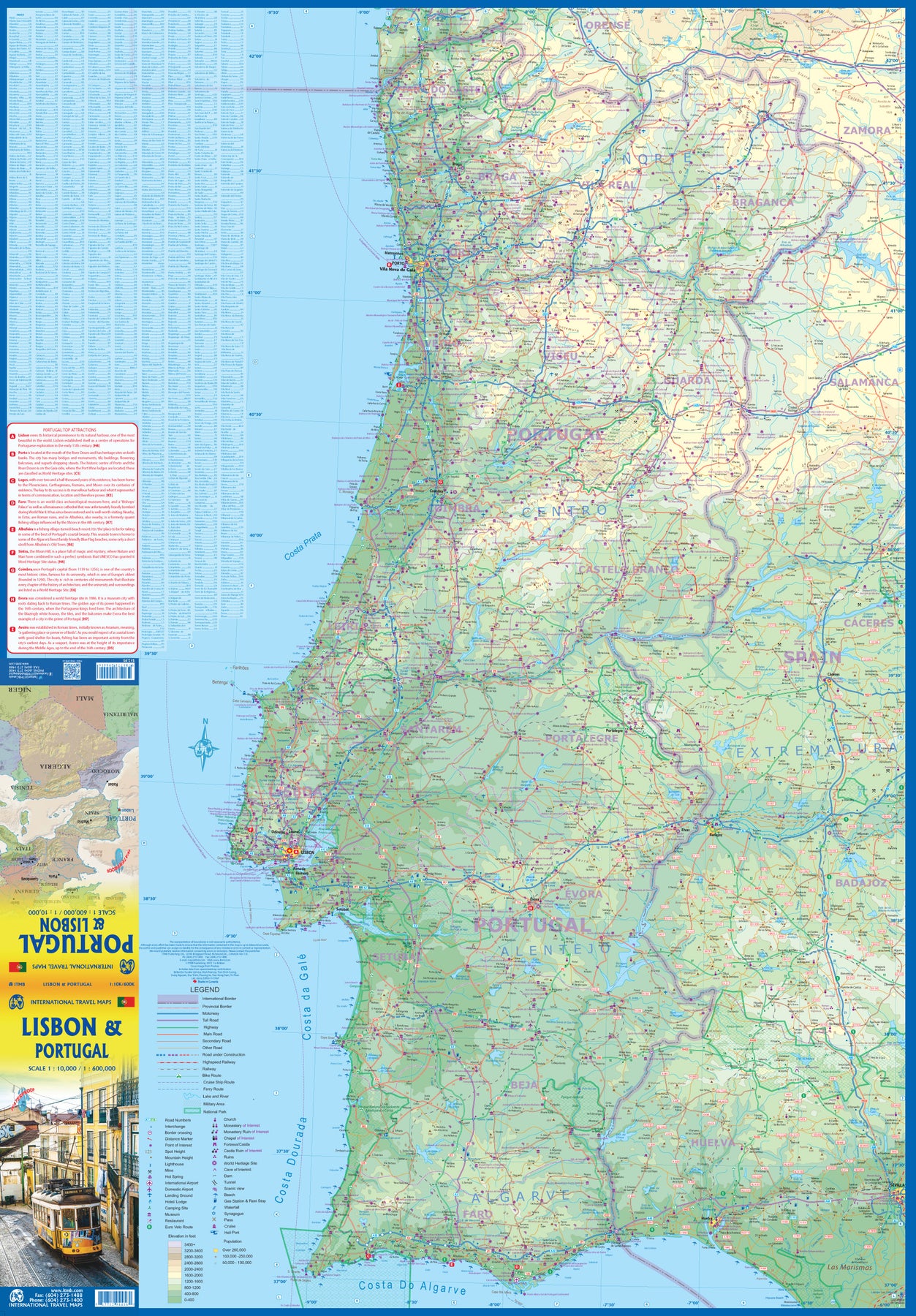
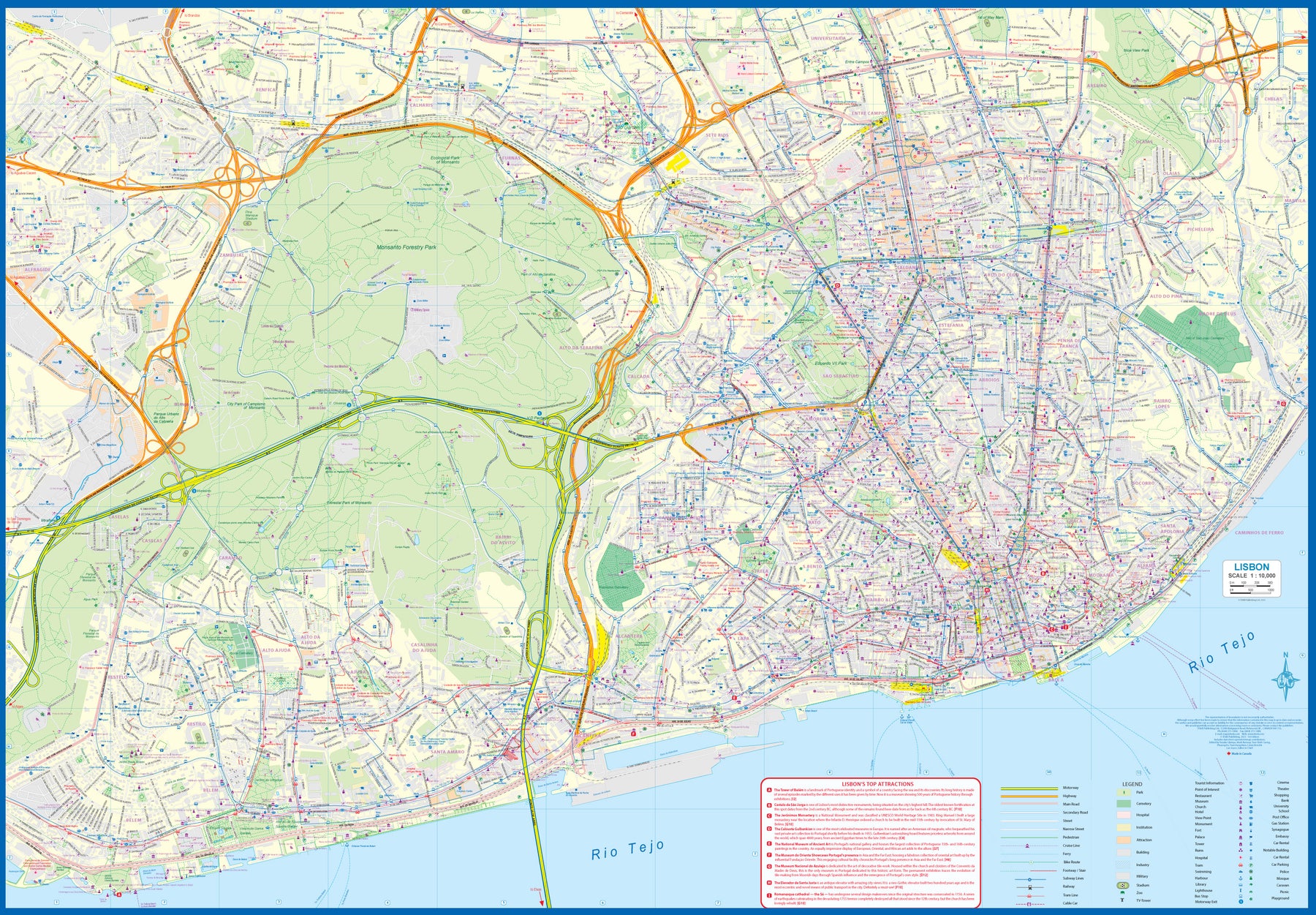
Portugal: Lisbon & Portugal
Ordinær pris 199,00 kr/
Mva inkludert
Frakt beregnes i kassen.
The city of Lisbon is one of the most attractive in Europe. It is an ancient city, but most of its architecture dates from the Victorian era. It has a fascinating number of tram lines, and the trams tend to be an experience worth the trip. One graces our cover. There is no cheaper way to explore this city than to climb aboard and let the rails decide your destination!
Coverage extends from the northern and western motorways to the southerly Rio Tejo and the national museum, so shows the city quite comprehensively. Almost half of the map area is of the massive Monsanto Park, one of the largest urban parks in the world. The reverse side is equally important, in that it presents our first-ever map dedicated to showing the charms of the entire country of Portugal. A bit of western Spain is included due to the unevenness of the border, but the map goes from the northernmost tipoff Castelo to the southernmost expanse of the Costa Do Algarve, showing touristic attractions, historic sites, beaches, museums, rail connections, and major parks.
The map is printed on waterproof stone paper, a recent technological innovation that is gradually replacing plastic.
- Publisert: 2023
- Innbinding: Falset
- Materiale: Vannfast papir
- Målestokk: 1:10 000, 1:600 000

Mediterranean Cruising
Ordinær pris 199,00 kr/
Mva inkludert
Frakt beregnes i kassen.
ITM har kart over hele verden og de spesialiserer seg på land litt utenfor allfarvei. Beliggenheten til landets nasjonalparker, historiske monumenter, de viktigste veiene o.L. Finner du inkludert i kartene. Samtlige landkart har ofte et bykart over hovedstaden.
Fra ITM: We are very pleased to present our very first cruising map covering the Mediterranean Sea. This is a double-sided map covering the eastern portion on side 1 and the western part on side 2. We were presented with a dilemma in designing this map, in that the shape of the sea is such that to include the straits of Gibraltar and the Dardanelles on the same map, a compromise would be necessary.
As few cruise ships now go to the North African coast, we concentrated on showing only the portion from Morocco to Tunisia so we could show Spain, France, Italy, Greece, the Balkans, and the Eastern Mediterranean, including the Black Sea. Little did we know that war in Europe would impact so intensely on what should be a pleasurable touristic map. Regardless, almost all of the ports of call for cruise ships in 2022 are shown on this map, including those favoured by smaller liners in the Adriatic Sea. We have also included common ferry routes between Italy and Greece and Marseille to Algiers.
- Publisert: 2022
- Innbinding: Falset
- Materiale: Papir
- Målestokk: 1:2 200 000

Guam & West Pacific Cruising
Ordinær pris 169,00 kr/
Mva inkludert
Frakt beregnes i kassen.
We are very pleased to be (finally) able to publish the first travel map of the island of Guam. Certainly, this is the only map of Guam by any major cartographic publishing house. Here are some details: Guam is a north-south island considerably north of New Guinea, and forms part of the American-held group of islands known as the Northern Marianas. Its capital is Hagatna, and the main town is called Tamuning. The island has a well-developed international airport in the middle portion of the island, with a large US military airbase in the northeast corner. The vast majority of the island is touristic, and well worth a visit. The island was "discovered" by Ferdinand Magellan in 1521, and Hagatna is the oldest "European" city in the Pacific, dating from 1686. The town of Inarajan retains a decidedly Spanish appearance to this day. Other attractions include Tumon Beach and its many resorts, the Piti Underwater Observatory, and the famous Cocos Island dive wall.
This is a double-sided map, with the Western Pacific Cruising map gracing the second side of the page. This side covers several island entities, and stretches from Australia in the south to Japan in the north and as far to the east as Hawaii and the Cook Islands, so includes such popular cruise destinations as Fiji, Tonga, New Caledonia, the Solomons, Papua, Samoa, Kiribati, and the Marshall Islands. It makes a lovely wall map!
- Publisert: 2022
- Innbinding: Falset
- Materiale: Papir
- Målestokk: 1:55 000/1:12 000 000

USA: Nevada & California North
Ordinær pris 169,00 kr/
Mva inkludert
Frakt beregnes i kassen.
ITM har kart over hele verden og de spesialiserer seg på land litt utenfor allfarvei. Beliggenheten til landets nasjonalparker, historiske monumenter, de viktigste veiene og lignende finner du inkludert i kartene. Samtlige landkart har ofte et bykart over hovedstaden.
Fra ITM: The USA is one of the most challenging countries to map due to its strong identification with state boundaries. Last month, we introduced two new maps of Idaho and Montana; this month, we wish to introduce Nevada. As a state, Nevada is mostly desert-like and is lightly populated. Its two major urban areas, Las Vegas and Reno, are extremely popular travel destinations. In addition, Nevada offers the Hoover Dam, one of the seven wonders of the modern world, a national park with 5,000-year-old pine trees, America’s second deepest lake (Tahoe), the eighth highest mountain peak in the USA, and the biggest air force bombing range in the world (Nellis). The map is double-sided, and covers northern California on the other side. This includes such treasures as Death Valley, part of the Mojave Desert, Yosemite National Park, the beautiful sequoia trees in the far northeast corner, and man-made wonders such as the Golden Gate Bridge and Highway 1 along the Big Sur coastline. Nevada is a valuable addition to ITMB’s growing line of State maps; after all, it’s about the size of France!
Publisert år: 2021
Innbinding: falset
Material: vanntettpapir
Målestokk: 1:875,000

India: Mumbai & West Coast
Ordinær pris 179,00 kr/
Mva inkludert
Frakt beregnes i kassen.
Mumbai, formerly Bombay, is the largest city on India's west coast. Tradditionally known as the Gateway to India, it is a huge, bustling metropolis. Our map covers the city centre and lower portion of the peninsula, with a detailed inset map showing the overall urban area. The map also includes the city's Top Attractions. Mumbai is also one of the major entry points for flights into India, which is why we have re-worked the map into a double-sided product with the west coast of India, from the far south to north of Surat. This essentially covers southern India and provides an excellent supplement for those visiting India starting with Mumbai. The popular enclaves of Goa, Damien, and Pondicherry are also included, as is the crossing to Sri Lanka.
- Publisert: 2019
- Innbinding: Falset
- Materiale: Vannfast papir
- Målestokk: 1:600 000, 1:8400


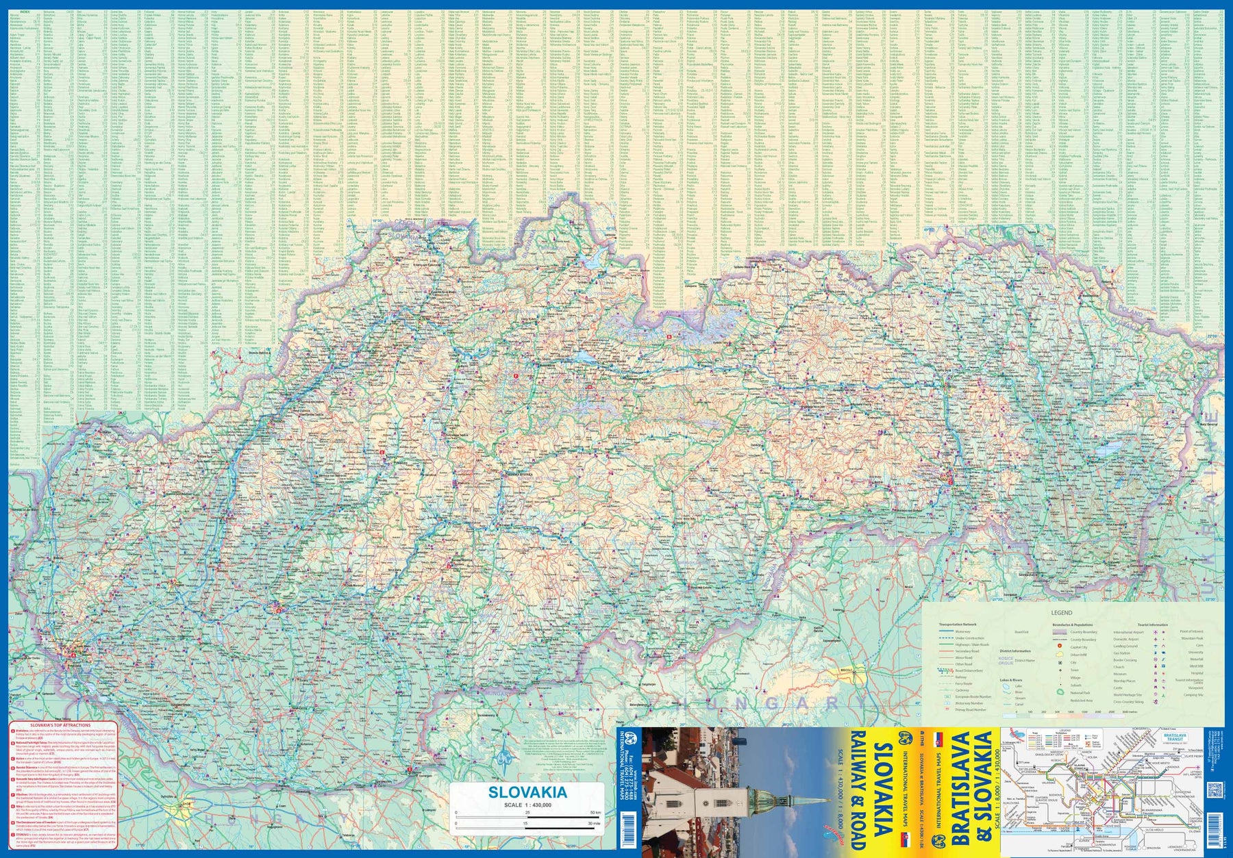

Slovakia - Railway & Road
Ordinær pris 169,00 kr/
Mva inkludert
Frakt beregnes i kassen.
As tourism to the eastern reaches of Europe becomes more popular, Slovakia is well-positioned to present an attractive opportunity for exploration. ITMB previously included this country with adjacent Hungary, but now we have expanded coverage and included a detailed map of Bratislava (1:8.000). Side 1 (1:430.000) shows the elongated country from its Austrian and Czech borders to its increasingly important border with Ukraine. As usual, we have included a listing of Top Attractions, such as the little-known towns of Kosice, Banska Stiavnica, and Sturovo, as well as the karst underground caves of Demanova and the fairy tale castle of Bojnice.
Side 2 portrays the capital city of Bratislava in excellent detail, showing the Danube River and the old town in great detail, along with the newer outlying areas of Petrzalka and Ruzinov. The map is printed on waterproof stone paper for durability. Legend Includes: Roads by classification, Rivers and Lakes, National Park, Airports, Points of Interests, Highways, Main Roads, Zoos, Fishing, and much more...
- Publisert: 2021
- Innbinding: Falset
- Materiale: Vanntett papir
- Målestokk: 1:8000, 1:430 000


Taiwan & Taipei
Ordinær pris 199,00 kr/
Mva inkludert
Frakt beregnes i kassen.
Taiwan always reminds me of the “little engine that could”. Despite having to endure an extremely hostile neighbour, the country has prospered, is democratic, and is friendly and welcoming to visitors, despite the fact that most governments do not officially recognize its existence. Side 1 shows the capital city of Taipei, a bustling economic powerhouse on the Damshui River, close to the ocean. The city has numerous hotels and shopping areas, and a well-developed subway network.
The second side covers the complete island of Formosa from top to bottom in excellent detail, as well as the off-shore Penghu islands (these can be reached by ferries from Kaohsung or Dongshih). Most of the country’s development is on the western, or Taiwan Straits, side of the mountainous country, but to me the Taroka Gorge, leading inland from Hualien on the east coast, is one of the wonders of modern Asia. An inset map of Tainan in southeast Taiwan is also included.
- Publisert: 2024
- Innbinding: Falset
- Materiale: Vannfast papir
- Målestokk: 1:386 000, 1:16 000

Brazil: Sao Paulo & Brazil South Coast
Ordinær pris 189,00 kr/
Mva inkludert
Frakt beregnes i kassen.
ITM har kart over hele verden og de spesialiserer seg på land litt utenfor allfarvei. Beliggenheten til landets nasjonalparker, historiske monumenter, de viktigste veiene o.L. Finner du inkludert i kartene. Samtlige landkart har ofte et bykart over hovedstaden.
Fra ITM: Sao Paulo is Brasil’s second-largest city and most vibrant area. The Centro, or downtown area, is quite compact, and consists of two pedestrian areas separated by a large park. The street pattern is much better arranged than in Rio, and the city has a sensible subway network. The Cathedral is the largest in Latin America, and nearby is one of the oldest churches, dating from 1644. The other side of the sheet is the real value of this map. Brasil is a very large country, with much of its road network concentrated in the heavily-populated far south. Thus, a map of the entire country reduces usability. We have added a proper map of the southern third of Brasil, from the Uruguayan border north to Brasilia and from the Argentinian border eastwards to east of Rio. This map includes most of the largest cities in Brasil, Rio, Sao Paulo, Belo Horizonte, Brasilia, Curitiba, and Puerto Alegre. An inset of Rio is included.
Publisert år: 2018
Innbinding: falset
Material: papir
Målestokk: 1:12000/2200000


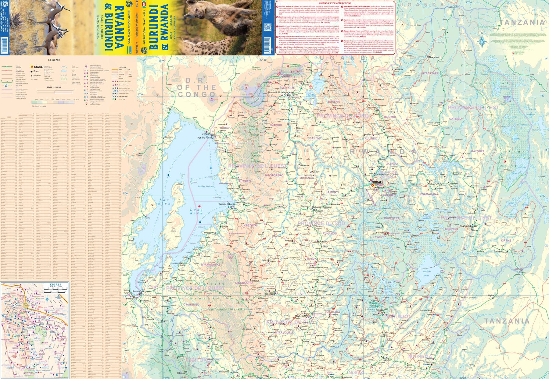
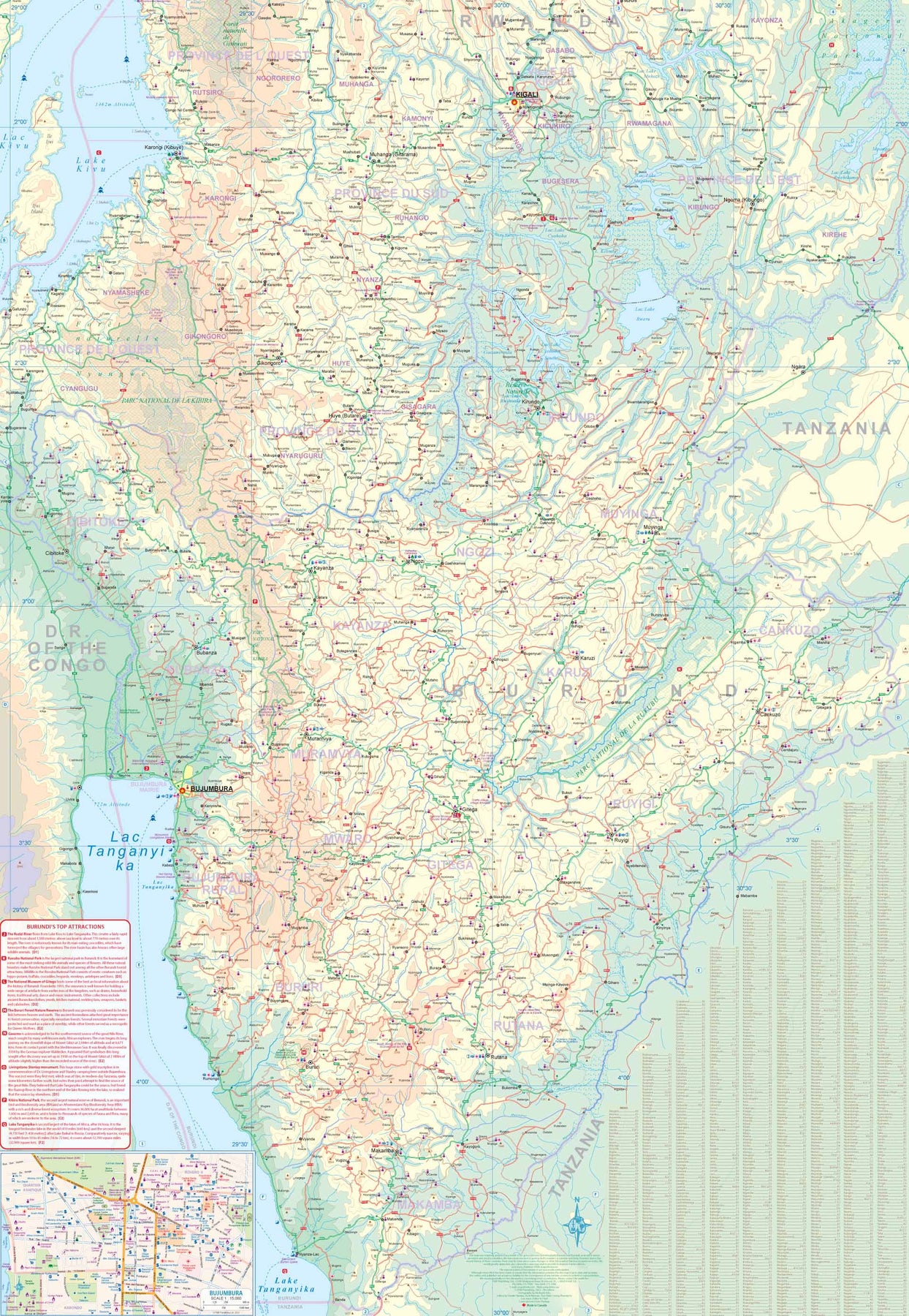
Rwanda & Burundi
Ordinær pris 199,00 kr/
Mva inkludert
Frakt beregnes i kassen.
ITM har kart over hele verden og de spesialiserer seg på land litt utenfor allfarvei. Beliggenheten til landets nasjonalparker, historiske monumenter, de viktigste veiene og lignende finner du inkludert i kartene. Samtlige landkart har ofte et bykart over hovedstaden.
- Publisert: 2023
- Innbinding: Falset
- Materiale: Papir
- Målestokk: 1:300 000

Mauritania & Mali
Ordinær pris 169,00 kr Salgspris 84,50 kr Spar 50%/
Mva inkludert
Frakt beregnes i kassen.
ITM har kart over hele verden og de spesialiserer seg på land litt utenfor allfarvei. Beliggenheten til landets nasjonalparker, historiske monumenter, de viktigste veiene o.L. Finner du inkludert i kartene. Samtlige landkart har ofte et bykart over hovedstaden.
Fra ITM: In this edition, we have combined Mauritania with Mali. Although both are interesting countries, the two fit naturally together as a unit, albeit at slightly differing scales. Technically, this should be a 1st edition map, as it is the first time we have combined these two desert countries on to one sheet, but I’ll let Robert at the Library of Congress worry about the niceties of bibliographic accuracy as soon as Trump allows him to do the work he loves for a salary. Mauritania was one of the most unusual countries I visited as a young traveller. Of course, I had an advantage, in that I was too young to know that what I was doing was supposed to be impossible. I entered from what was then the Spanish Sahara via a piste (a sandy track with multiple pathways, only some of which avoid soft sand), travelling with a young Bedouin man. In Zouerate, a mining camp, I had to tie my VW campervan onto a railway flatbed car, and endure hundreds of kilometres of a sand dune wasteland before reaching Choum, and a siding where I could off-load the vehicle. The track south to Nouakchott was covered with sand and treacherous. Nowadays, there is a paved road to the southern border of Morocco, and a good road all the way along the coast to Rosso, where a ferry can take one across to Senegal. Mali adjoins Mauritania, both being formerly part of French West Africa. The capital, Bamako, is an interesting town with quite a bit of colonial architecture still in place. East of there is Djenne, a ‘forbidden’ city for infidels when I was there (see cover photo), but a fascinating mud-brick city. Further east again is Mopti, a river port where camel caravans off-load tablets of salt mined still far in the Sahara for transport by boat to Dakar. Further east again is Timbuktu (or Tombouctou as it is now spelled), at one time the most exotic isolated destination known to mankind. Further south is the Bandiagara escarpment, a must-see living area for locals who have created a living space from the sheer walls of the cliff. Both countries are fascinating places to visit.
Publisert år: 2019
Innbinding: falset
Material: Papir
Målestokk: 1:2,200,000 / 1:900,000


Costa Rica
Ordinær pris 199,00 kr/
Mva inkludert
Frakt beregnes i kassen.
This is an ITMB title that is so popular it needs no explanation. This is the most recent edition of a tried-and true title that has been a mainstay of our Central American line since the early 1980s. Folded double-sided road map Inset maps: Central San Jose City, Environs of San Jose. List of Costa Rica's Top Attractions. Legend includes: Highways, roads, railways, lakes, rivers, national parks, hotels, gas stations, museums, beaches, waterfalls and more.
- Publisert: 2024
- Innbinding: Falset
- Materiale: Vannfast papir
- Målestokk: 1:300 000

China: South & Guangzhou
Ordinær pris 149,00 kr Salgspris 119,00 kr Spar 20%/
Mva inkludert
Frakt beregnes i kassen.
China, as a country, is very popular with travellers. However, China is also a very large geographical entity and showing the entire country on one map results in a scale that reduces the amount of information that can be shown. The most visited part of the country is the south, with rapid train access from Hong Kong and major airports at Guangzhou and Shanghai. Travel to China is also increasing as more international airports are opened.
The regional map covers one side of this double-sided map; the other contains an updated map of Guangzhou (formerly Canton). Lan and I visited this city in February and were surprised at how open and modern the city is. In comparison with Beijing, the political overtones are much reduced, and Sun Yat Sen is the hero. The city is also a major train hub, with two major stations handling traffic, and six bus stations arranging transportation to nearby cities.
- Publisert: 2015
- Innbinding: Falset
- Materiale: Papir
- Målestokk: 1:3 000 000, 1:15 000

Angola
Ordinær pris 199,00 kr/
Mva inkludert
Frakt beregnes i kassen.
ITM har kart over hele verden og de spesialiserer seg på land litt utenfor allfarvei. Beliggenheten til landets nasjonalparker, historiske monumenter, de viktigste veiene o.L. Finner du inkludert i kartene. Samtlige landkart har ofte et bykart over hovedstaden.
Fra ITM: Angola is emerging as one of Africa’s growing travel destinations. After a long period of isolation, the country now welcomes tourists, and is investing in improved infrastructure to make it easier to travel around this vast country. New resort hotels are attracting tourists to beach hotels along the coast and inland hotels are being upgraded. The road network is improving, but still is a work in progress. The USA is building a new trans-Africa railway, but its future is uncertain due to Trump’s cutbacks. The map includes a detailed inset map of Luanda, the capital, and a list of Top Attractions. Angola is still a developing country, so travel here is more adventuresome than in eastern Africa for example, but it is growing in popularity.
Publisert år: 2025
Innbinding: falset
Material: papir
Målestokk: 1:1,430,000