98 produkter
98 produkter


98 produkter
Mongolia
Ordinær pris 199,00 krThe country of Mongolia has existed for centuries, but until recent times was dominated by Russia. When we were first asked to prepare a tourism-oriented map of Mongolia by the government, we did our best using then-available sources of data. With each new edition, we have improved the amount of information and the accuracy of spelling of place names as the country has developed. For example, it is now generally accepted that the name of the country’s capital is Ulaanbaatar as one word.
Roads in Mongolia tend to vary dramatically, so most of the thin red lines should be regarded as guidelines rather than as formal man-made roads. The Gobi Desert is well-shown, as are cities little-known to outsiders.
A detailed inset map of Ulaanbaatar is included.
Legend Includes: Highway, Other Roads, Motorway, Railway, Urban area, Border crossing, Airport, Point of interest, Monument, Museum, Mine, Ruin, Gas station, Lake, Nature Reserve, Camping Site, Sand dunes, Glacier, etc.
Mount Xixabangma
Ordinær pris 220,00 krMyanmar (Burma)
Ordinær pris 189,00 krDette store østerriske kartforlaget er kjent for sin klare kartografi og gode papirkvalitet. De kommer i alle målestokker, og flere av landkartene inneholder bykart og turistinformasjon.
Burma (Myanmar) at 1:1,000,000 on a large, double-sided, indexed road map from Freytag & Berndt, with clear presentation of the country’s road network, its topography, various places of interest and its administrative divisions.
The map divides the country north/south, with a good overlap between the sides. Coverage includes the western part of Thailand with Bangkok and Chiang Mai and extends south to Phuket. Relief shading with spot heights shows the country’s topography. National parks and other protected areas are highlighted. Road network includes selected unpaved roads and local tracks; driving distances are indicated on main routes and locations of border crossings are marked. The map shows railway lines and local airports, as well as the country’s internal administrative boundaries with names of the provinces. Also marked are oil fields and pipelines. Small icons clearly highlight various places of interest. The map has latitude and longitude lines at intervals of 1º and an extensive index. Multilingual map legend includes English.
Publisert år: 2018
Innbinding: falset
Material: papir
Målestokk: 1:1200000
Myanmar (Burma)
Ordinær pris 169,00 krTysk kartserie med flotte kart på slitesterkt plastpapir.
Myanmar / Burma at 1:1,500,000 on an indexed, waterproof and tear-resistant road map with topographic and tourist information, published by Reise Know-How as part of their highly acclaimed World Mapping Project. The map is double-sided to provide the best balance between a good scale and a convenient size sheet, with a very generous overlap between the two sides. Coverage on the southern side extends east to Bangkok and south to Ko Samui and Surat Thani, indicating border crossings to Thailand.
Road and rail networks are easy to see on a clear base which presents topography by light altitude colouring with contours, spot heights, mountain passes and names of mountain ranges. Road network includes selected local tracks and gives driving distances on main roads. Internal administrative boundaries are shown with names of the provinces. National parks and protected areas are marked and symbols highlight various places of interest, including UNESCO world heritage sites, archaeological remains, temples and museums, viewpoints, beaches, etc. The map also shows old versions of many town names (Sittwe / Akyab, Bago / Pegu, Pyay / Prome, etc. Latitude and longitude lines are at intervals of 1º. Extensive index of localities also includes names of national parks, places of interest, etc. Map legend includes English.
Publisert år: 2017
Innbinding: falset
Material: plastpapir
Målestokk: 1:1500000
Myanmar (Burma)
Ordinær pris 149,00 krNelles dekker store deler av kloden og er spesielt gode på den ikke-vestlige verden. Bykart er innsatt i regionskartene, og du får avstandstabeller og avmerkede attraksjoner som for eksempel nasjonalparker.
Publisert år: 2019
Innbinding: falset
Material: Plastpapir
Målestokk: 1:1500000
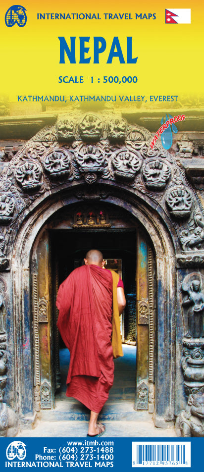
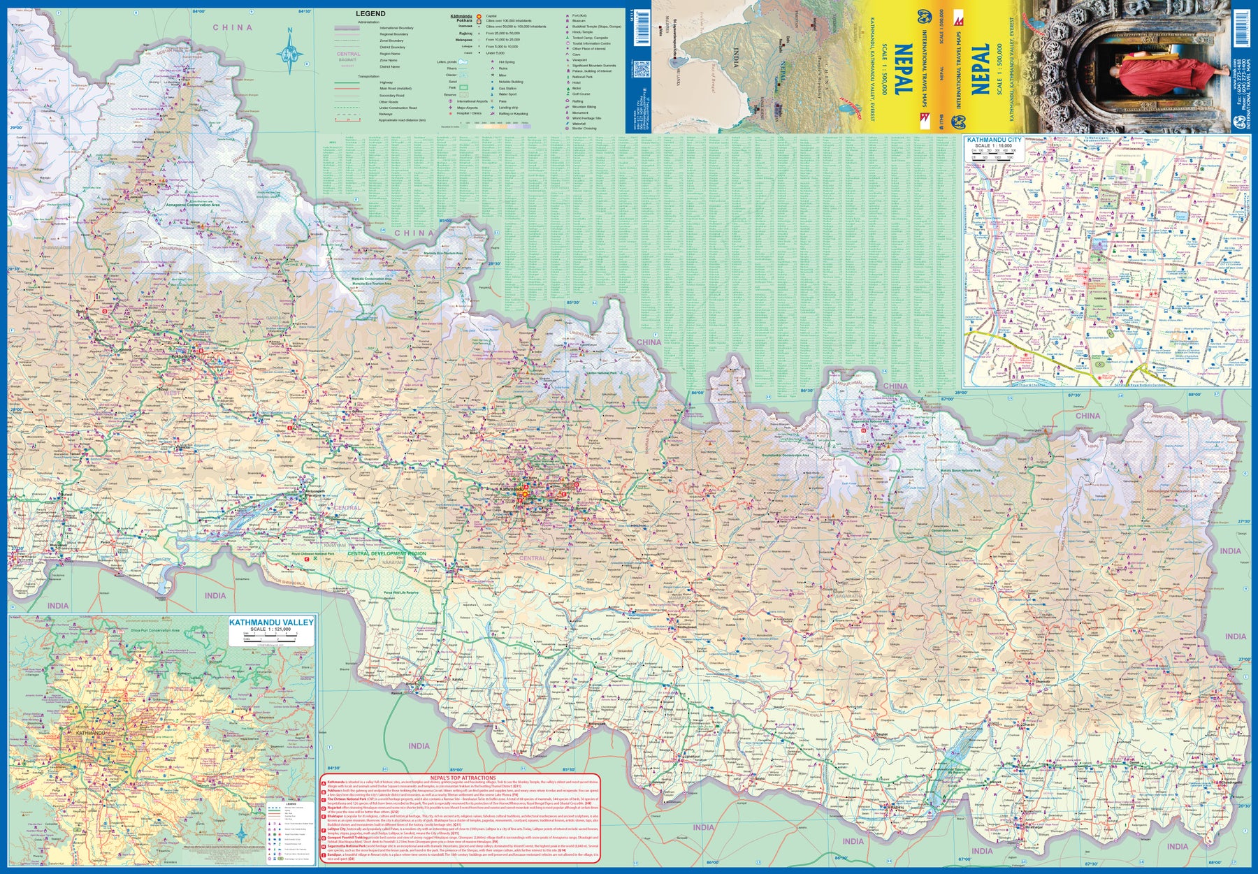
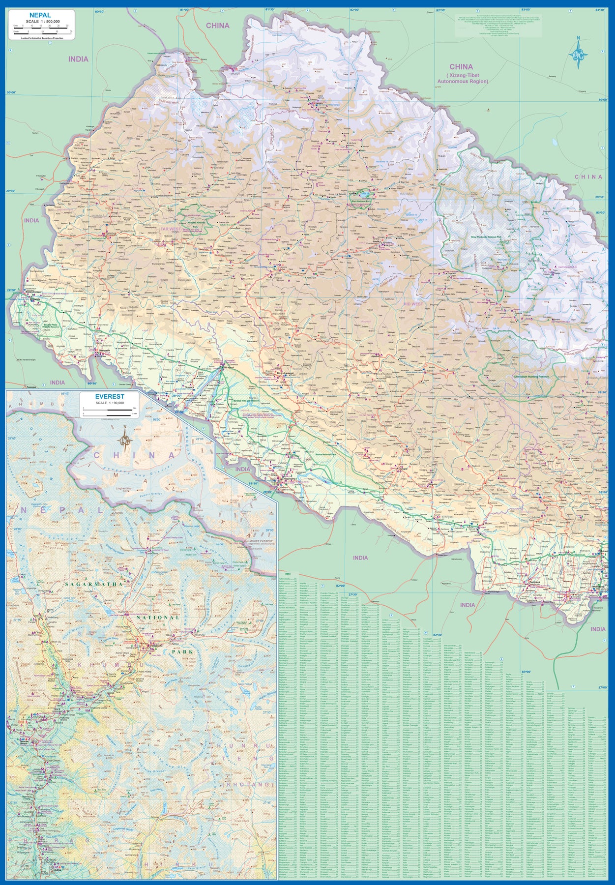
Nepal
Ordinær pris 199,00 krNow it is time to re-introduce the world to one of the most fascinating countries on Planet Earth. Side 1 covers western Nepal around Pokhara and has a detailed inset map of the Mount Everest area in an expanded scale. Side 2 covers the portion of the country from just west of the Annapurna Glacial region eastwards through Kathmandu to the eastern border. A very detailed inset map of Kathmandu is included, as one of the Kathmandu Valley that surrounds the city. Basic road access from India is shown. It is not possible to enter from China.
The map is printed on durable stone paper and is as up to date as we could make information under very trying circumstances. We still hope to visit next year. Nepal is a treasure!
Pakistan
Ordinær pris 169,00 krTysk kartserie med flotte kart på slitesterkt plastpapir.
Pakistan on a light, waterproof and tear-resistant, indexed map with topographic and tourist information, published by Reise Know-How as part of their highly acclaimed World Mapping Project. The map is double-sided to provide the best balance between a good scale and a convenient size sheet.
Topography is shown by altitude colouring with spot heights, mountain passes and names of mountain ranges, deserts, etc. Seasonal rivers and lakes, swamps, salt pans are also marked. Internal administrative boundaries are shown with names of the provinces.
Road network includes local roads, indicating driving distances on main routes and most secondary roads. Railways and local airfields and ports are also shown. Symbols mark locations of various places of interest, including UNESCO world heritage sites, archaeological remains, national parks and other protected areas, etc. The map has a grid with latitude and longitude at intervals of 1º and an extensive index of localities with a separate list of national parks and reserves. Map legend includes English.
Publisert år: 2019
Innbinding: falset
Material: plastpapir
Målestokk: 1:1300000
Philippines 3022
Ordinær pris 249,00 krThe Philippines, an archipelago of over 7,000 islands in southeast Asia, offer an extraordinary fusion of cultures and rich biodiversity. National Geographic's Philippines Adventure Map provides global travelers with the perfect combination of detail and perspective in a highly functional travel tool. Each of the three principal geographic divisions of the country - Luzon, Visayas, and Mindanao - are detailed. The front side of the print map shows Luzon and includes an inset of the Batanes province. The Visayan Islands, Mindanao, and an inset of the province of Tawi-Tawi are shown on the reverse side. Cities and towns are easy to find with the map's helpful index. Highways and major roads as well as minor and secondary roads are clearly designated and include distance in kilometers so travelers can easily plan their best route. National parks and reserves, World Heritage sites, hot springs, beaches, points of interest, and areas for surfing and diving are indicated so travelers can take advantage of the Philippines' many natural attractions and activities. The locations of airports, airfields, railroads, and ferry routes take the guesswork out of travel around the islands. Every Adventure Map is printed on durable synthetic paper, making them waterproof, tear-resistant and tough — capable of withstanding the rigors of international travel..
Saudi Arabia
Ordinær pris 269,00 krHighly tear-resistant and 100% waterproof map "Saudi Arabia" from the series world mapping project.
Travel know-how maps are characterized by particularly sturdy plastic paper, which can be written on like paper, even with a pencil. The cardboard envelope is removable, making it easy to put the card in any pocket. A protective cover is not required. The cartographic representation focuses on the most important information for travelers and is particularly easy to read. Instead of shading, colored layers of elevation are used.
Seoul
Ordinær pris 119,00 krShanghai
Ordinær pris 119,00 kr
Lonely Planet City Map er slitesterkt og vanntett, med en hendig slipcase og et format som er lett å brette. Få mer ut av kartet og reisen din med bilder og informasjon om byattraksjoner, transportkart, reiseruteforslag, omfattende gate- og nettstedsindeks og praktiske reisetips. Med dette brukervennlige navigasjonsverktøyet i baklommen kan du virkelig komme til hjertet av din destinasjon!
Silk Road (To China through Central Asia)
Ordinær pris 229,00 krTysk kartserie med flotte kart på slitesterkt plastpapir.
Singapore
Ordinær pris 119,00 krLonely Planet City Map er slitesterkt og vanntett, med en hendig slipcase og et format som er lett å brette. Få mer ut av kartet og reisen din med bilder og informasjon om byattraksjoner, transportkart, reiseruteforslag, omfattende gate- og nettstedsindeks og praktiske reisetips. Med dette brukervennlige navigasjonsverktøyet i baklommen kan du virkelig komme til hjertet av din destinasjon!
Sri Lanka & India South
Ordinær pris 199,00 krThis edition is a considerable improvement on our previous one, benefitting from the extensive research trip we took to the emerald-shaped island shortly before the outbreak of Covid changed the world. We have re-introduced it as a map printed on waterproof paper, as such a format holds up well in a hot, humid climate. We visited all parts of the island and were quite impressed by the number of local hotels and resorts that we found and have added to the map. We were particularly gratified to discover progress on extending the motorway system for the country, much of it now probably delayed due to Covid.
The inset map of Colombo is particularly well-done. The second side of the sheet is a very detailed map of the southern third of India, from Nagpur to the southern tip of the country. Space constraints did not allow for inset maps, but several well-known cities are included – Mumbai, Hyderabad, Chennai, Pondicherry, Madurai, and Bengaluru (Bangalore) among them. India is a fascinating, if somewhat intimidating, place to visit, but is well-worth the time to do so.
Syria & Lebanon
Ordinær pris 199,00 krGizi Map er en serie presise kart med detaljer og opplysninger over både populære og mindre populære reisemål. Dekker ofte områder der få andre kartprodusenter dekker.
Taiwan
Ordinær pris 169,00 krOur maps combine state-of-the-art, GPS-compatible cartography (including hypsometric tints and contour lines) with a detailed rendering of road networks and touristic information. They offer the best possible scale, level of detail and readability, be it a map of a small island or half a continent.
The maps feature a detachable paper sleeve so that the maps can be folded easily and fit in every pocket. Although printed on plastic, a special coating makes sure the maps retain a paper-like feel and can even be written on with a pencil.
Taiwan & Taipei
Ordinær pris 199,00 krTaiwan always reminds me of the “little engine that could”. Despite having to endure an extremely hostile neighbour, the country has prospered, is democratic, and is friendly and welcoming to visitors, despite the fact that most governments do not officially recognize its existence. Side 1 shows the capital city of Taipei, a bustling economic powerhouse on the Damshui River, close to the ocean. The city has numerous hotels and shopping areas, and a well-developed subway network.
The second side covers the complete island of Formosa from top to bottom in excellent detail, as well as the off-shore Penghu islands (these can be reached by ferries from Kaohsung or Dongshih). Most of the country’s development is on the western, or Taiwan Straits, side of the mountainous country, but to me the Taroka Gorge, leading inland from Hualien on the east coast, is one of the wonders of modern Asia. An inset map of Tainan in southeast Taiwan is also included.
Thailand
Ordinær pris 199,00 krThailand at 1:900,000 on a large, double-sided, indexed road map from Freytag & Berndt, with clear presentation of the country’s road network, its topography, various places of interest and its administrative divisions.
The map divides the country north/south, with a good overlap between the sides. Colouring and relief shading with spot heights show the country’s topography. National parks and other protected areas are clearly highlighted. Road network includes selected unpaved roads and local tracks, with driving distances indicated on main routes. The map also shows railway lines, ferry connections and local airports, as well as the country’s internal administrative boundaries with names of the provinces.
Various places of interest at highlighted by symbols with their names given in English, e.g. ancient or historic city, floating market, historic park, etc. The map has latitude and longitude lines at intervals of 1º and an extensive index. Map legend includes English.
Three Passes - Everest/Gokyo
Ordinær pris 299,00 kr1:50,000 scale map printed on waterproof, durable material. This beautiful, folded map, is the perfect reference map, guidebook, and planner aid to anyone attempting this long, difficult trekking adventure.
Features three passes;
Kongma La
Chola Pass
Renjola Pass
Tsum Valley
Ordinær pris 199,00 krTsum Valley in central Nepal on an indexed contoured map at 1:100,000 from Shangri-La Design highlighting local trekking routes and places of interest, etc. Coverage extends roughly from the Budhi Gandaki River in the west across the eastern part of the Manaslu Conservation area, to just beyond Dunche in the east.
Topography is shown by contours at 40m intervals, plus colouring for woodlands, cultivated areas, glaciers, etc. The map shows local roads and distinguished between main trekking routes and minor trails. An overprint indicates various facilities in local villages, campsites, monasteries and other religious buildings, etc. The map is indexed for places, peaks and passes and had latitude and longitude margin ticks at 5’ intervals. Map legend includes English.
Addition information provided on the map or on its cover includes a table with relative oxygen rates at different altitudes, elevation profiles and hiking times for three main routes, plus general information about the area. All the text is in English.
Publisert år: 2009
Innbinding: falset
Material: papir
Målestokk: 1:100.000
Turkmenistan
Ordinær pris 249,00 krGizi Map er en serie presise kart med detaljer og opplysninger over både populære og mindre populære reisemål. Dekker ofte områder der få andre kartprodusenter dekker.
United Arab Emirates & Abu Dhabi
Ordinær pris 169,00 krITM har kart over hele verden og de spesialiserer seg på land litt utenfor allfarvei. Beliggenheten til landets nasjonalparker, historiske monumenter, de viktigste veiene og lignende finner du inkludert i kartene. Samtlige landkart har ofte et bykart over hovedstaden.
We are pleased to release this brand new ITMB title. Abu Dhabi is one of the leading Emirates that are rapidly becoming vacation heavens for Europeans who don't want the long flights to Asian destinations. The city is so modern it almost squeaks. The palace is a world-class wonder, the seafront Corniche is a marvelous beach, and the central shopping area offers everything from hamburgers to Gucci bags. Motorways now connect the city state to nearby Dubai and to Oman, with a recently-completed one along the coastline to the Saudi border.
The reverse side of the map is an updated edition of the entire United Arab Emirates and most of Oman, with new motorways seemingly everywhere. A large inset map of central Dubai is included, along with a good one of Muscat. We docked at Abu Dhabi's cruise ship terminal during our visit and were impressed by the extent of urbanization of the city.
United Arab Emirates & Dubai
Ordinær pris 199,00 krITM har kart over hele verden og de spesialiserer seg på land litt utenfor allfarvei. Beliggenheten til landets nasjonalparker, historiske monumenter, de viktigste veiene og lignende finner du inkludert i kartene. Samtlige landkart har ofte et bykart over hovedstaden.
Fra ITM: Dubai is truly becoming a very popular travel destination and the loose federation of sheikdoms collectively known as the United Arab Emirates is growing in popularity with each passing year. Despite the turmoil affecting both Israel and Iran, this part of the Middle East is open for business and peaceful. Side 1 concentrates on the overall region from the eastern border of the UAE to its interaction with Oman. It also has an excellent inset map of Abu Dhabi, the capital of the UAE. Side 2 concentrates on Dubai itself as the largest urban area. Dubai has an extensive and interesting old town on the east bank of the Dubai Creek, which is where most of the hotels and the huge international airport are located. The ‘new town’ is on the left bank, and this is where one finds Western-style shopping areas, high-rise towers, the rapid transit line, and the main motorway out of town. The World Trade Center and Emirates Towers are also centrally located. The man-made Coastal Projects are shown in insets.
Uzbekistan; Kyrgyzstan; Tajikistan
Ordinær pris 199,00 krFinally, our ITMB map of Uzbekistan is back in print! Tourism to the ‘Stans’ is increasing as these former parts of the Soviet Empire find their way in a changing world. This time, we have combined the country with the two other Stans on one side, which makes sense given their shape; then, on the reverse side, we have expanded the artwork to show Kyrgyzstan and Tajikistan to good advantage.
The map also includes excellent inset maps of Samarkand, Tashkent, Dushanbe, and Bishkek, which I’m sure all are familiar names. Needless to say, all three countries count as ‘adventure’ travel. Facilities are good in major cities, but roads are of an uncertain quality, and accommodations sparse. Still, this is an exceptionally interesting part of the world. The traditional Great Silk Road passed through this region, and to this day Tashkent is a major trading transfer point. Nine points of major interest are included, including the Ark-Citadel dating from 400BC, the Minaret of Kalta-Minor, and the great Caravanserai from the Middle Ages.