188 produkter
188 produkter


188 produkter
Italy: Sardinia & Cagliari
Ordinær pris 189,00 krSardinia at a detailed scale of 1:150,000 on a large, double-sided map in Freytag & Berndt’s very popular “Top 10 Tips” series. A booklet attached to the map cover provides descriptions of the region’s 10 best sights. Street plans, presented on the map itself rather than in the booklet, show the centres of Cagliari, Sassari, Nuoro, Alghero, Oristano and Olbia. Many place names are in large print to make navigating easier.
Italy: Sicily; Sardinia & The South
Ordinær pris 169,00 krITM har kart over hele verden og de spesialiserer seg på land litt utenfor allfarvei. Beliggenheten til landets nasjonalparker, historiske monumenter, de viktigste veiene og lignende finner du inkludert i kartene. Samtlige landkart har ofte et bykart over hovedstaden.
Italy: Southern Tyrol (Bolzano)
Ordinær pris 199,00 krItalian region of South Tyrol, with coverage extending across the Austrian border to Innsbruck, at a detailed scale of 1:150,000 on a map in Freytag & Berndt’s very popular “Top 10 Tips” series. A booklet attached to the map cover provides descriptions of the region’s 10 best sights, street plans of Bolzano, Merano and in Austria Lienz, plus the map index. Many place names are in large print to make navigating easier. Coverage includes the Dolomites.
Lombardy
Ordinær pris 189,00 krMarco Polo er svært detaljerte kart som er praktiske og enkle i bruk. 7 klistremerker for å markere spesifikke steder gjør det enda enklere å planlegge reisen. Alle kartene inneholder en omfattende index for enkelt å finne frem.
Mediterranean Cruising
Ordinær pris 199,00 krITM har kart over hele verden og de spesialiserer seg på land litt utenfor allfarvei. Beliggenheten til landets nasjonalparker, historiske monumenter, de viktigste veiene o.L. Finner du inkludert i kartene. Samtlige landkart har ofte et bykart over hovedstaden.
Fra ITM: We are very pleased to present our very first cruising map covering the Mediterranean Sea. This is a double-sided map covering the eastern portion on side 1 and the western part on side 2. We were presented with a dilemma in designing this map, in that the shape of the sea is such that to include the straits of Gibraltar and the Dardanelles on the same map, a compromise would be necessary.
As few cruise ships now go to the North African coast, we concentrated on showing only the portion from Morocco to Tunisia so we could show Spain, France, Italy, Greece, the Balkans, and the Eastern Mediterranean, including the Black Sea. Little did we know that war in Europe would impact so intensely on what should be a pleasurable touristic map. Regardless, almost all of the ports of call for cruise ships in 2022 are shown on this map, including those favoured by smaller liners in the Adriatic Sea. We have also included common ferry routes between Italy and Greece and Marseille to Algiers.
Milan
Ordinær pris 119,00 krPadova
Ordinær pris 199,00 krPalermo
Ordinær pris 169,00 kr
Sardinia
Ordinær pris 189,00 krMarco polo er svært detajerte kart som er praktiske og enkle i bruk. 7 klistremerker for å markere spesifikke steder gjør det enda enklere å planlegge reisen. Alle kartene inneholder en omfattende index for enkelt å finne frem.
Fully updated, Marco Polo maps feature completely up-to-date, digitally generated mapping. The high quality cartography with distance indicators and scale converters aid route planning. Includes a city map of Cagliari. Major sights and key points of interest are marked on the map by numbered stars and these are listed in the index booklet with a brief description to help travellers pick the best places to see en route. Comprehensive index.
Publisert: 2024
Innbinding: falset
Material: papir
Målestokk: 1:200,000
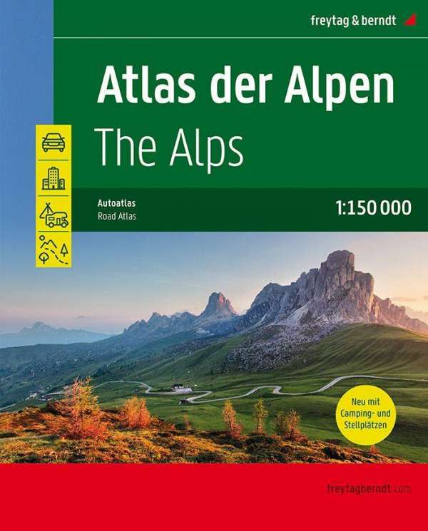
The Alps Atlas
Ordinær pris 449,00 krTuscany
Ordinær pris 199,00 krTuscany (Toscana)
Ordinær pris 199,00 krMarco polo er svært detajerte kart som er praktiske og enkle i bruk. 7 klistremerker for å markere spesifikke steder gjør det enda enklere å planlegge reisen. Alle kartene inneholder en omfattende index for enkelt å finne frem.
Fully updated, Marco Polo maps feature completely up-to-date, digitally generated mapping. The high quality cartography with distance indicators and scale converters aid route planning. Includes a city map of Cagliari. Major sights and key points of interest are marked on the map by numbered stars and these are listed in the index booklet with a brief description to help travellers pick the best places to see en route. Comprehensive index.
Publisert: 2025
Innbinding: falset
Material: papir
Målestokk: 1:225,000
Venice
Ordinær pris 99,00 krKart i postkortstørrelse. Folder seg ut som en popoutbok når du åpner dem. Fargerik turistinformasjon med kart over metro og busstraseer, landemerker og lignende. Veldig enkel å håndtere.
Publisert: Apr. 2024
Innbinding: pop
Material: papp, papir
Venice
Ordinær pris 149,00 krBorch Maps are easy to fold, durable and water-repellent with a wipeable surface. Borch Maps show hotels, museums, monuments, markets, public transport, top sights and points of interest, useful statistics, conversion charts for temperatures, weights and measurements, climate charts showing temperatures, sunshine hours, precipitation and humidity, overview maps, time zones, and much more...