14 produkter
14 produkter


14 produkter
2260 Azoren
Ordinær pris 259,00 kr592 Portugal Centre
Ordinær pris 169,00 krMichelin er en av verdens beste, og best kjente, kartserier. Kartene har glimrende kartografi.
594 Madeira
Ordinær pris 169,00 krMichelin er en av verdens beste, og best kjente, kartserier. Kartene har glimrende kartografi.
595 Azores
Ordinær pris 169,00 krMichelin er en av verdens beste, og best kjente, kartserier. Kartene har glimrende kartografi.
Algarve & Portugal South
Ordinær pris 199,00 krMarco Polo Algarve Map - the ideal map for your trip. Let the Marco Polo Algarve Road Map guide you around this beautiful southern region of Portugal. Discover heavenly beaches and picturesque mountain villages with this highly durable, detailed, touring map of Algarve. It folds away easily and is always on standby to help when you're stuck.
Costa de Lisboa
Ordinær pris 169,00 krThe regional map show the combination of geographical information and GPS references. The map include an index of places and street plans of main cities in the region. The maps show the road and rail networks on a base with altitude coloring and highlight various places of interest and facilities.
Lonely Planet Lisbon
Ordinær pris 119,00 krLonely Planet City Map er slitesterkt og vanntett, med en hendig slipcase og et format som er lett å brette. Få mer ut av kartet og reisen din med bilder og informasjon om byattraksjoner, transportkart, reiseruteforslag, omfattende gate- og nettstedsindeks og praktiske reisetips. Med dette brukervennlige navigasjonsverktøyet i baklommen kan du virkelig komme til hjertet av din destinasjon!
Lonely Planet Porto
Ordinær pris 119,00 krLonely Planet City Map er slitesterkt og vanntett, med en hendig slipcase og et format som er lett å brette. Få mer ut av kartet og reisen din med bilder og informasjon om byattraksjoner, transportkart, reiseruteforslag, omfattende gate- og nettstedsindeks og praktiske reisetips. Med dette brukervennlige navigasjonsverktøyet i baklommen kan du virkelig komme til hjertet av din destinasjon!
Portugal
Ordinær pris 199,00 krITM har kart over hele verden og de spesialiserer seg på land litt utenfor allfarvei. Beliggenheten til landets nasjonalparker, historiske monumenter, de viktigste veiene o.L. Finner du inkludert i kartene. Samtlige landkart har ofte et bykart over hovedstaden.
Fra ITM: We are very pleased to be able to release a double-sided detailed map of Portugal. Although we have included the country in previous maps, it was always as an adjunct to another map (Spain and Portugal, Portugal and Southern Spain etc.), so it is high time that this very nice popular country had its own ITM map. Being a long, rather thin country, Side 1 concentrates on Lisbon and the southern half of Portugal with a detailed inset map of Lisbon. It also includes the Spanish provinces of Huelva and Badajoz. Side 2 covers the northern half of the country along with portions of neighbouring Spanish provinces. As a country, Portugal has a wealth of touristic attractions and we have included as many as we can on this map without cluttering it – castles, palaces, fortresses, cathedrals and churches, dozens of museums, beaches, a few hotels, mines, monuments, and just about everything a visitor would want to have. Of course, motorways, highways, secondary routes, rail lines, ferry services, and geographic heights of land are also included; altogether, a fabulous map for a wonderful country.
Publisert år: 2025
Innbinding: falset
Material: Papir
Målestokk: 1:500,000
Portugal: Azores
Ordinær pris 199,00 krPortugal: Azores Walking & Cycling Map Set
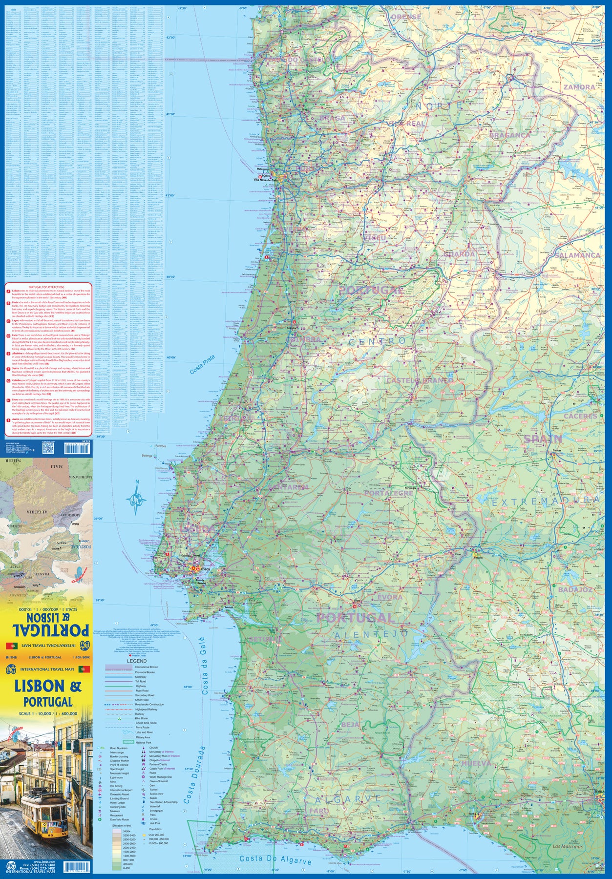
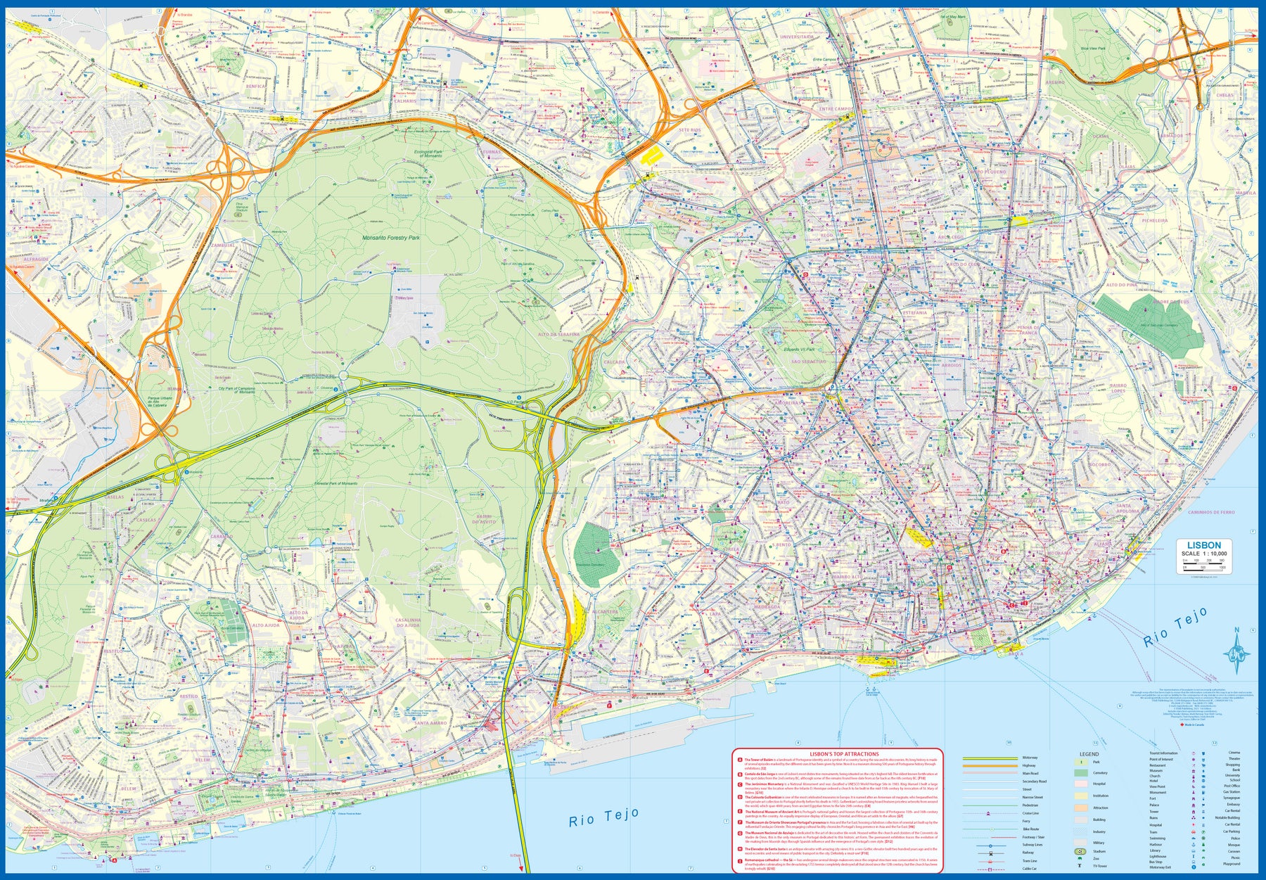
Ordinær pris 219,00 krPortugal: Lisbon & Portugal
Ordinær pris 199,00 krThe city of Lisbon is one of the most attractive in Europe. It is an ancient city, but most of its architecture dates from the Victorian era. It has a fascinating number of tram lines, and the trams tend to be an experience worth the trip. One graces our cover. There is no cheaper way to explore this city than to climb aboard and let the rails decide your destination!
Coverage extends from the northern and western motorways to the southerly Rio Tejo and the national museum, so shows the city quite comprehensively. Almost half of the map area is of the massive Monsanto Park, one of the largest urban parks in the world. The reverse side is equally important, in that it presents our first-ever map dedicated to showing the charms of the entire country of Portugal. A bit of western Spain is included due to the unevenness of the border, but the map goes from the northernmost tipoff Castelo to the southernmost expanse of the Costa Do Algarve, showing touristic attractions, historic sites, beaches, museums, rail connections, and major parks.
The map is printed on waterproof stone paper, a recent technological innovation that is gradually replacing plastic.
Sintra Cascais Nature Park
Ordinær pris 299,00 krTopographic map on the scale 1/25 000, subtitled in Portuguese, English, Spanish, French and German. Waterproof, with functional compass.
Includes the whole network of paths in the Nature Park, tourist attractions such as monuments, beaches, camping sites, picnic areas, tourist offices, surf spots, climbing, diving and free flight, among others.
Spain & Portugal & Andorra
Ordinær pris 169,00 krMarco Polo Spain and Portugal Map: the ideal map for your trip. Let the Marco Polo Spain and Portugal Road Map guide you around these wonderful countries. Explore Spain and Portugal's highways and byways with this highly durable, detailed, touring map. It folds away easily and is always on standby to help when you're stuck.