275 produkter
275 produkter


275 produkter
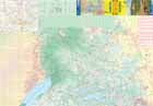
St. Martin/St. Maarten & Anguilla
Ordinær pris 169,00 krITM har kart over hele verden og de spesialiserer seg på land litt utenfor allfarvei. Beliggenheten til landets nasjonalparker, historiske monumenter, de viktigste veiene o.L. Finner du inkludert i kartene. Samtlige landkart har ofte et bykart over hovedstaden.
Fra ITM: Anguilla is a popular cruise ship destination. This island occupies all of side one, with inset maps of Dog Island, Prickley Pear Cays, and aptly-named Scrub Island. Anguilla enjoys several sandy beaches, only some of which have been developed for resort use, and those ‘resorts’ that do exist tend to be modest operations. The west end Village area seems to have the most beaches, with resorts on Barnes Bay and Maunday’s Bay, but the best beach is a bit further east, at Rendezvous Bay. Crocus Hill, in the centre of the island, contains most of the shopping facilities for the island, and Shoal Bay, on the northern coast has another lovely beach resort area. The other side of the map is devoted to what must be the most unusual aspect of the Caribbean – a relatively small island shared by two European powers, France and Netherlands. The island is Saint Martin (it’s French as well as its English name) or Sint Maarten (its Dutch name). The Dutch occupy the south half of the island, with the cruise ship terminal at Philipsburg, the capital. The town is located along a stretch of beach and is only three streets wide. On the other side of town is Great Salt Pond, so the town has no place in which to expand, so is very congested. Touristic attractions tend to spread out from the town along the south coast. If one rents a car, it is a very enjoyable trip to the north half (the French part) of the island. There is no border, so the only difference is language. Both halves of the island use the Euro as their currency. The northern half has two well-developed beach resort beaches at Orient Bay and at Baie de Grand Case The capital, Marigot, contains most of the shops The highest point of land on the island is Pic Paradis (424m) in the French portion. Inset maps of Philipsburg and Marigot are included. 1st edition 2019. Scales:Anguilla 1:23.000, Saint Martin 1:20.000/Sint Maarten 1:23.000.
Publisert år: 2019
Innbinding: falset
Material: Papir
Målestokk: 1:20,000 / 1:23,000
Sudan & South Sudan
Ordinær pris 179,00 krITM har kart over hele verden og de spesialiserer seg på land litt utenfor allfarvei. Beliggenheten til landets nasjonalparker, historiske monumenter, de viktigste veiene og lignende finner du inkludert i kartene. Samtlige landkart har ofte et bykart over hovedstaden.
Surinam & French Guiana
Ordinær pris 149,00 krITM har kart over hele verden og de spesialiserer seg på land litt utenfor allfarvei. Beliggenheten til landets nasjonalparker, historiske monumenter, de viktigste veiene o.L. Finner du inkludert i kartene. Samtlige landkart har ofte et bykart over hovedstaden.
Publisert år: 2009
Innbinding: falset
Material: papir
Målestokk: 1:750000
Tanzania: Kilimanjaro & Tanzania North
Ordinær pris 199,00 krKili remains eternally popular. This most recent update includes a listing of Top attractions for this dormant volcano. The reverse side of the map covers all of northern Tanzania and the portion of Kenya that includes Nairobi. The islands of Pemba and Zanzibar are also shown. This side also includes an inset map of Arusha, the town from which almost all treks to Kilimanjaro begin, an inset of Dar es Salaam, and another of Stone City, in Zanzibar. This map recently won an award from the International Mountaineering Association for excellence.
Inkl. bykart over Dar es Salaam; Zanzibar & Arusha
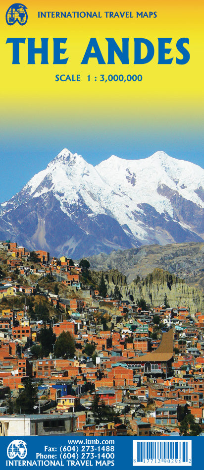
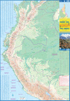
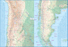
The Andes
Ordinær pris 199,00 krThe Andes mountain chain is the southern extension of the Sierra Nevada chain through Mexico and Central America, which is, in turn the southern extension of the Rocky Mountain chain from Alaska to the Mexican border. The Andes is a magnificent series of high mountains that enters Colombia and spreads southwards through Ecuador and Peru all the way to southern Patagonia.
The map is double-sided, with the Northern Andes on one side and the other side divided into two side-by-side maps portraying the Central Andes and the Southern Andes. Thus, the map coverage focuses on the Andes themselves, rather than on all of South America. All of Colombia and Peru are shown, most of Bolivia, all of Chile, and the Patagonian portion of Argentina except for the southern portion of Tierra del Fuego. The importance of this map is that it focuses on the highland areas of the continent, where much of the population lives. Bogota, Medellin, Quito, Lima, Arequipa, La Paz, Santiago, Talca, and Punta Arenas are all located along the spine of the Andes. So are the Torres del Paine peaks, the Montt Glacier, and numerous volcanoes, touristic sites, and twisting mountain roads.
Togo & Benin
Ordinær pris 169,00 krITM har kart over hele verden og de spesialiserer seg på land litt utenfor allfarvei. Beliggenheten til landets nasjonalparker, historiske monumenter, de viktigste veiene og lignende finner du inkludert i kartene. Samtlige landkart har ofte et bykart over hovedstaden.
Fra ITM: The two small countries squeezed between Ghana on the west and Nigeria on the east developed out of the European colonialization of most of Africa Germany, under Kaiser Bill, was determined to create an empire to rival that of Britain, and seized a portion of the coastline close to the British-held area of Ghana and held on to it until WW1 ended Germany’s colonial aspirations. Britain and France jointly governed Togo briefly, but the territory was ceded to France until independence was granted in the 1960s. Neighbouring Benin (formerly the French colony of Dahomey) was all that the French colonial office could obtain of the rich coastal plain until the German defeat in WW1, which gained it Togo and German Cameroun, further to the east. Both countries have their points of interest, but to this day have little to do with each other. There is one border crossing on the coast, and a couple of others much farther inland, but each country operates on a north-south basis, not an east-west one. The map includes inset maps of Lome, the capital of Togo, and Porto Novo, in Benin, which is now the capital. Togo’s best sites are noted in a red inset box, with a separate box for Benin.
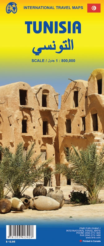
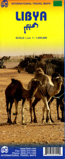
Tunisia & Libya
Ordinær pris 149,00 krITM har kart over hele verden og de spesialiserer seg på land litt utenfor allfarvei. Beliggenheten til landets nasjonalparker, historiske monumenter, de viktigste veiene o.L. Finner du inkludert i kartene. Samtlige landkart har ofte et bykart over hovedstaden.
Publisert år: 2011
Innbinding: falset
Material: plastpapir
Målestokk: 1:1650000
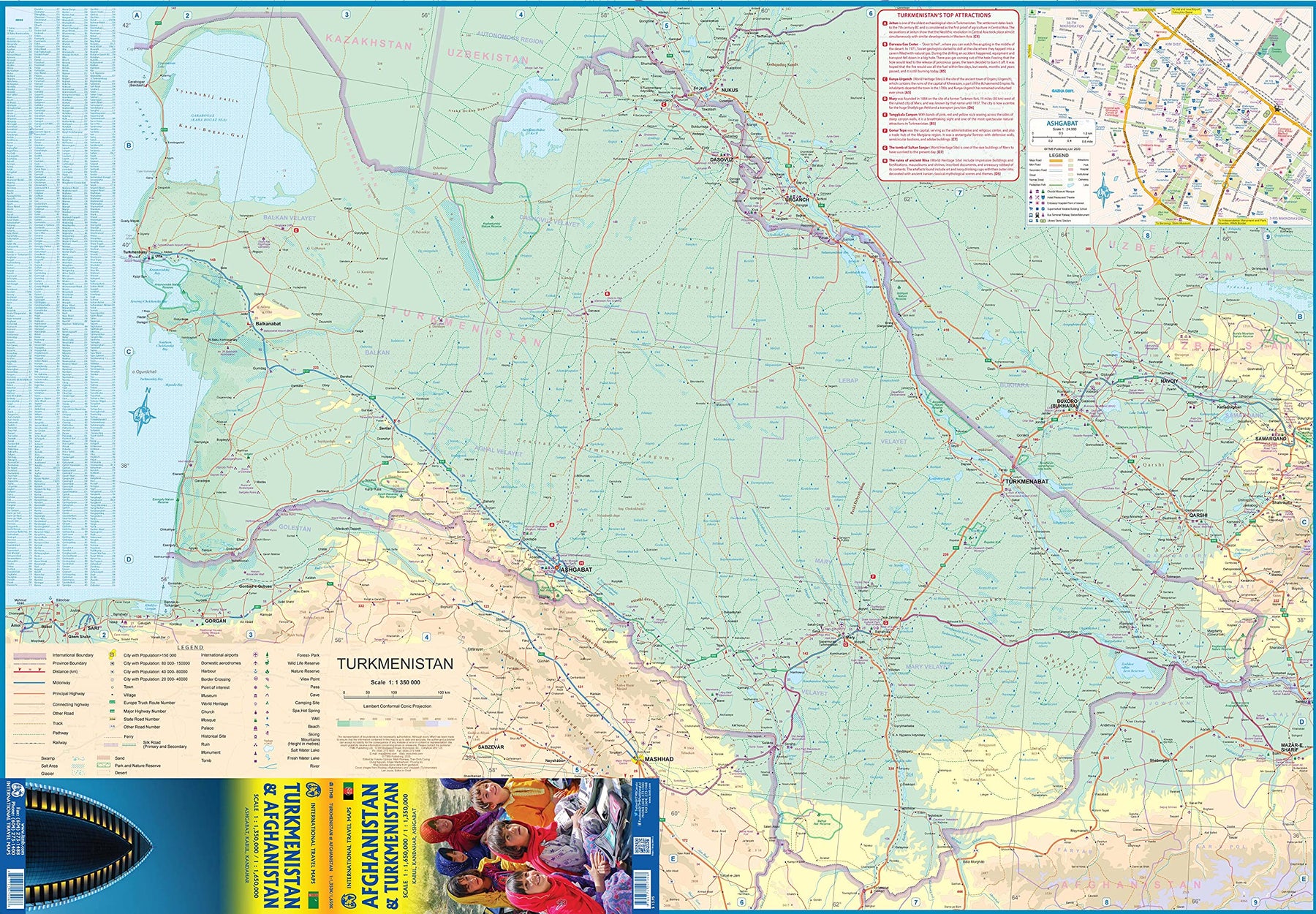
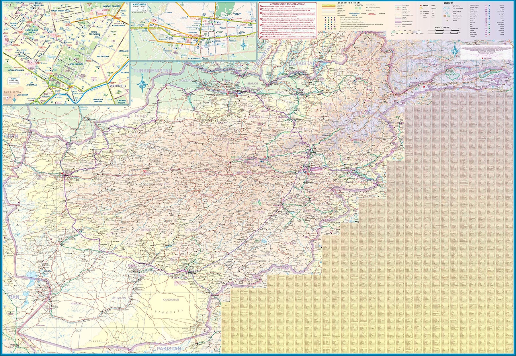
Turkmenistan & Afghanistan
Ordinær pris 179,00 krThe world is changing as a result of a global pandemic, and ITMB has to change with it. We wish to keep all of our artwork available, but at a time of greatly reduced travel, we have been forced to combine two different countries that share a common border in order to justify printing either one. The two countries, Afghanistan and Turkmenistan, do share a common heritage, but a very different history. ITMB Publishes a separate map of the country, and a map of Kabul. The reason for this map is that it is our first ever map of just Turkmenistan, a former part of the USSR that broke away in the collapse of the Russian empire in 1990. The country has, however, not emerged from the Soviet way of thinking, and is authoritarian in its attitude. It is, fortunately, open to travel, and is slowly improving its facilities, so is to be encouraged.
The map includes a very good inset map of Ashgabat, the capital. The country stretches from the Caspian Sea to the Uzbek border and from Russia south to Iran and Afghanistan. We have also added eight Top Attractions, ranging from the World Heritage site of Konye to the ancient ruins of Nisa. We previously published this titles as part of a regional map of the ‘Stans’, but growing demand has justified its own map. We have also published a separate map of Uzbekistan and a separate three-country map of the other three countries, all of which are showing strong signs of touristic development. Turkmenistan is a country emerging as a future travel Mecca. Legend Includes: Roads by classification, Rivers and Lakes, National Park, Airports, Points of Interests, Highways, Main Roads, Zoos, Fishing, and much more...
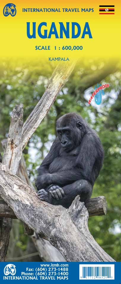
Uganda
Ordinær pris 189,00 krITM har kart over hele verden og de spesialiserer seg på land litt utenfor allfarvei. Beliggenheten til landets nasjonalparker, historiske monumenter, de viktigste veiene og lignende finner du inkludert i kartene. Samtlige landkart har ofte et bykart over hovedstaden.
Fra ITM: The Jewel of Africa, Uganda is a lovely country to visit. Most of the development is in the south, close to Lake Victoria. To me, the most interesting parts are the game parks in the far west and in the far north, but the Mount Elgon area is interesting as well. This updated map also includes a large inset map of Kampala, the capital. The map has been updated to last for the next few years and, by being printed on plastic, is guaranteed to remain durable as well as waterproof.
USA: Arizona & New Mexico
Ordinær pris 169,00 krITM har kart over hele verden og de spesialiserer seg på land litt utenfor allfarvei. Beliggenheten til landets nasjonalparker, historiske monumenter, de viktigste veiene o.L. Finner du inkludert i kartene. Samtlige landkart har ofte et bykart over hovedstaden.
Fra ITM: This version includes two separate covers, one for each state, to enhance marketing possibilities, and the addition of two Top Attractions listings, one for each state. The Arizona side has a detailed inset map of Flagstaff, showing the path of Route 66 through the city streets. The New Mexico side includes a large inset of Albuquerque, also including the Route 66 passageway through the city.
Publisert år: 2022
Innbinding: falset
Material: Papir
Målestokk: 1:900000
USA: East Coast
Ordinær pris 179,00 krITM har kart over hele verden og de spesialiserer seg på land litt utenfor allfarvei. Beliggenheten til landets nasjonalparker, historiske monumenter, de viktigste veiene o.L. Finner du inkludert i kartene. Samtlige landkart har ofte et bykart over hovedstaden.
This is a new title for ITMB, portraying the Atlantic coast states from Maine to Florida. It replaces our former map of USA East Half, which has been discontinued. Side 1 covers from the northern tip of Maine to partway through North Carolina and west to Pittsburgh in Pennsylvania. Side 2 continues south to Key West at the southern tip of Florida and west as far as Atlanta and just short of New Orleans. This is a companion map to our new map covering the central portion of the USA called Mississippi (essentially the Louisiana Purchase territory). The USA seems to fit naturally into north-south components - the Atlantic Coast is the former British colonies with the addition of Spanish Florida, and the central portion covers the lands affected by the Mississippi River basin and the great plains known as the Mid-West. This particular map is one for exploration of a vast portion of the USA from top to bottom. It would be useful for anyone living in this segment of the country to explore and would suit foreign visitors a readable map of an important part of America. Where exactly IS Gettysburg, anyway? Well, it's on the map, as well as Disneyworld, the Boone Hall Plantation, and Nantucket. This is a map for exploring! So go explore. This map is ideal for the visitor needing a map of the Rockies that includes all the passes and parks in the region, while also showing the cities and road/rail infrastructure. Naturally, wilderness campsites are included. ITMB also publishes separate maps of each province.
Publisert år: 2024
Innbinding: falset
Material: Papir
Målestokk: 1:1,500,000
USA: Florida & Deep South
Ordinær pris 149,00 krITM har kart over hele verden og de spesialiserer seg på land litt utenfor allfarvei. Beliggenheten til landets nasjonalparker, historiske monumenter, de viktigste veiene o.L. Finner du inkludert i kartene. Samtlige landkart har ofte et bykart over hovedstaden.
Publisert år: 2014
Innbinding: falset
Material: plastpapir
Målestokk: 1:1000000
USA: Hawaii
Ordinær pris 179,00 krThe American state of Hawaii can only sensibly be mapped either as separate islands or as an entity using a series of insets, due to the distances between the islands. We have previously published the major islands as separate entities, but the state as an entity has also proven to be very popular. This updated version on waterproof paper shows each major island in excellent detail. Side 1 covers Oahu, Maui, Lanai, and Kaho'Olawe at scales of approximately 1:100,000 each. Side 2 covers Big Island, Kauai, Molokai, and Ni'ihau at scales between 1:120,000 and 1:300,000.
For each island, we have striven to create detailed artwork showing each one to best advantage., with double lines between each island to cut out intervening ocean. The back cover serves as an inset showing all the islands in relation to each other. Naturally, all touristic sites are included, as well as major accommodation centres.
USA: Hawaii - Maui; Kauai & Molokai
Ordinær pris 169,00 krITM har kart over hele verden og de spesialiserer seg på land litt utenfor allfarvei. Beliggenheten til landets nasjonalparker, historiske monumenter, de viktigste veiene og lignende finner du inkludert i kartene. Samtlige landkart har ofte et bykart over hovedstaden.
Fra ITM: The island of Maui may not be at well-known as Oahu, which is extremely popular with Japanese honeymooners, but it is as attractive touristically. Our coverage covers most of Side 1 and includes a detailed inset map of Wailuku, the principal urban area, as well as insets of Lahaina on the west coast and Wailea resort area. This side also includes a map of the island of Lanai, with its main urban area of Lanai City as an inset. Side 2 concentrates on the islands of Molokai, Kauai, and the lightly populated island of Ni’ihau, and includes detailed inset maps of Lihue, Kaunakakai, and Po’ipu, all of which are major resort destinations. The islands are loaded with beaches and places to stay, but also with attractions, which are shown on the map. This is a beautiful map, one of the best we have ever produced, and is a fitting companion to our maps of Big Island, and Oahu/Honolulu, as well as our state map. The Maui/Kauai map also has a double-sided cover, so can be displayed as two separate maps.