Filter
- Albania
- Belgia
- Bosnia-Hercegovina
- Bulgaria
- Canada
- Danmark
- Estland
- Finland
- Frankrike
- Hellas
- Hviterussland
- Irland
- Island
- Italia
- Kosovo
- Kroatia
- Latvia
- Liechtenstein
- Litauen
- Luxembourg
- Malta
- Montenegro
- Nord-Makedonia
- Polen
- Romania
- Serbia
- Slovakia
- Slovenia
- Storbritannia
- Sveits
- Tsjekkia
- Tyskland
- Ukraina
- Ungarn
- Østerrike
72 produkter
72 produkter

Norway: Spitsbergen & Svalbard & Northern Norway
Ordinær pris 199,00 kr/
Mva inkludert
Frakt beregnes i kassen.
North of Norway exists one of the northernmost communities in the world, an archipelago of islands called Svalbard in Norwegian, and better known as Spitsbergen in English. Until now, it has only been available in map format from the Norwegian Arctic Institute, and then only with difficulty.
Side one shows the various islands as an entity. There is only one town of any size in the islands, called Longyearbyen, although there is a more northerly town called Pyramiden and an isolated community on the west coast called Ny Ålesund. This is true high Arctic adventure travel; one does not come here unprepared! Most of the islands are uninhabited and largely ice-covered. Edge Island, for example, is a large nature reserve, and Prins Karl Forland is a national park.
We have translated land area names into English and placed the Norwegian names in brackets, but have tried leaving the Norwegian names in place wherever possible to assist with local usage. This is one of those 'off the beaten path' type of travel destinations, such as appeal to Linblad Explorer ships. We actually include a list of Top Attractions! This is the most northerly land mass in the world, and Alesund is its most northerly urban area. The second side of the map is also uniquely interesting. It focuses on the far north of Norway, from Bodo all the way to Nordkapp and east to Norway's border with Russia. Northernmost Sweden and Finland are included as well, but the map really emphasizes how large Norway is. Rail lines, and there are some, are shown with a red/white line going as far as Narvik (from Sweden) and Bodo (from Oslo). 1:800.000.
- Publisert: 2020
- Innbinding: Falset
- Materiale: Papir
- Målestokk: 1:900 000, 1:800 000

Poland: Warsaw & East
Ordinær pris 149,00 kr/
Mva inkludert
Frakt beregnes i kassen.
ITM har kart over hele verden og de spesialiserer seg på land litt utenfor allfarvei. Beliggenheten til landets nasjonalparker, historiske monumenter, de viktigste veiene o.L. Finner du inkludert i kartene. Samtlige landkart har ofte et bykart over hovedstaden.
Fra ITM: This is, at the same time, our second edition updated map of Warsaw and a brand new title for ITMB, in that we have added a regional map of the eastern half of Poland to the second side of the map. This gives the end user two maps for the price of one by combining the many attractions of the city with its surrounding countryside. Anyone with a small amount of historical knowledge knows that Warsaw was largely destroyed during World War II. Many historic cities suffered this fate; in the case of Warsaw, the historic old town was re-built more or less as it had been, with some road widenings changing things, and the rest of the city was re-created as a post-war urban area. The old town is actually quite compact, so is shown in detail on an inset map, as is the greater Warsaw urban area The urban map shows rail and metro lines/stations, tram lines, churches, theatres, the enormous Soviet-era cultural centre, hotels etc. The regional map covers a very large portion of eastern Poland, from the eastern borders to Lodz, and includes the roads leading to Krakow and Gdansk; altogether, a perfect map for those using Warsaw as a base and exploring the hinterland on short trips.
Publisert år: 2018
Innbinding: falset
Material: papir
Målestokk: 1:10000


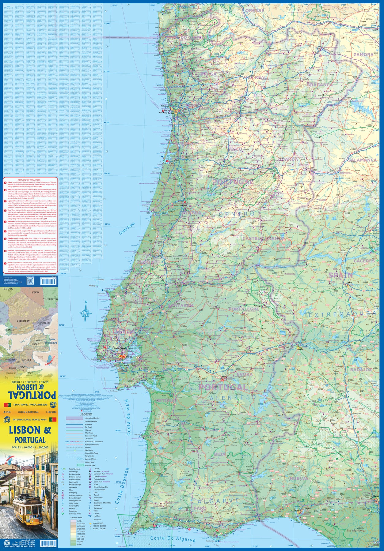
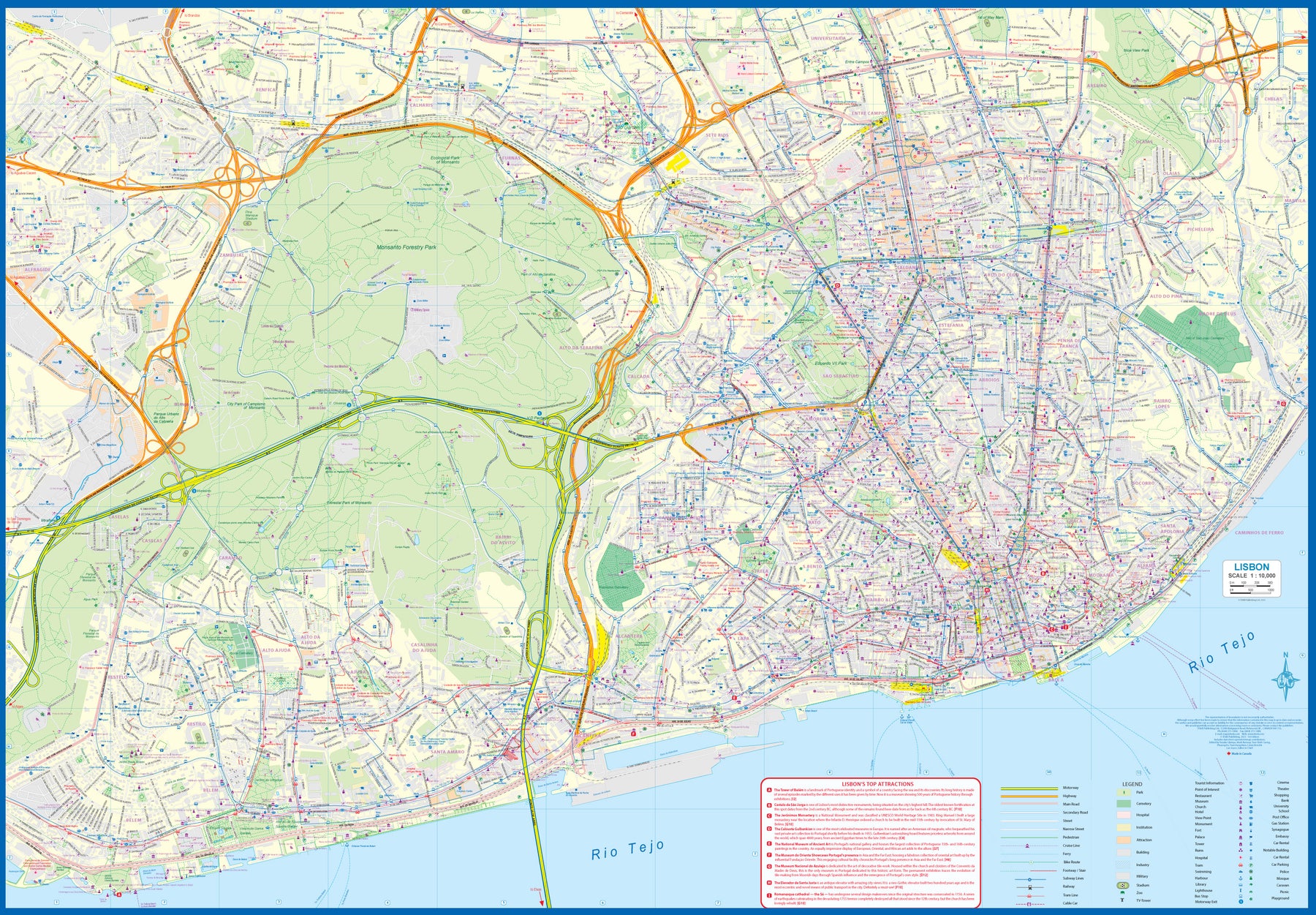
Portugal: Lisbon & Portugal
Ordinær pris 199,00 kr/
Mva inkludert
Frakt beregnes i kassen.
The city of Lisbon is one of the most attractive in Europe. It is an ancient city, but most of its architecture dates from the Victorian era. It has a fascinating number of tram lines, and the trams tend to be an experience worth the trip. One graces our cover. There is no cheaper way to explore this city than to climb aboard and let the rails decide your destination!
Coverage extends from the northern and western motorways to the southerly Rio Tejo and the national museum, so shows the city quite comprehensively. Almost half of the map area is of the massive Monsanto Park, one of the largest urban parks in the world. The reverse side is equally important, in that it presents our first-ever map dedicated to showing the charms of the entire country of Portugal. A bit of western Spain is included due to the unevenness of the border, but the map goes from the northernmost tipoff Castelo to the southernmost expanse of the Costa Do Algarve, showing touristic attractions, historic sites, beaches, museums, rail connections, and major parks.
The map is printed on waterproof stone paper, a recent technological innovation that is gradually replacing plastic.
- Publisert: 2023
- Innbinding: Falset
- Materiale: Vanntett papir
- Målestokk: 1:10,000 / 1:600,000

Russia
Ordinær pris 179,00 kr/
Mva inkludert
Frakt beregnes i kassen.
Russia is a very big country. West of the Ural Mountains is West Russia, with the reat tacked on almost as an after-thought, filling the second side. Most of the population is concentrated in the West, necessitating a better scale to provide enough space to note the many cities and the road/rail network. Most visitors fly into Moscow, then travel by train to other cities, primarily within the Russian heartland, but also by entraining for the Trans-Siberian Railway.
This necessitates the second side of the map sheet, covering the vast expanses of taiga and forest from Perm east to Vladivostok. This talks about a week by train. Theoretically, it is drivable if weather conditions permit. Geographically, this portion of Russia is much larger, so can only be shown at a somewhat reduced scale. For those wishing more detail, ITMB also publishes maps of Siberia and of the Far East Republic/Kamchatka Peninsula, as well as our famous road/train atlas of the Trans-Siberian rail network.
- Publisert: 2019
- Innbinding: Falset
- Materiale: Papir
- Målestokk: 1:3 200 000, 1: 6 300 000


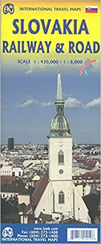
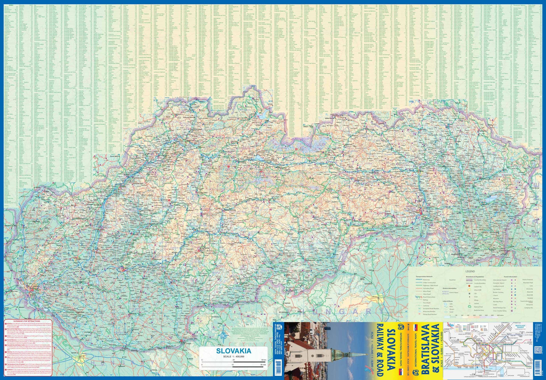

Slovakia - Railway & Road
Ordinær pris 169,00 kr/
Mva inkludert
Frakt beregnes i kassen.
As tourism to the eastern reaches of Europe becomes more popular, Slovakia is well-positioned to present an attractive opportunity for exploration. ITMB previously included this country with adjacent Hungary, but now we have expanded coverage and included a detailed map of Bratislava (1:8.000). Side 1 (1:430.000) shows the elongated country from its Austrian and Czech borders to its increasingly important border with Ukraine. As usual, we have included a listing of Top Attractions, such as the little-known towns of Kosice, Banska Stiavnica, and Sturovo, as well as the karst underground caves of Demanova and the fairy tale castle of Bojnice.
Side 2 portrays the capital city of Bratislava in excellent detail, showing the Danube River and the old town in great detail, along with the newer outlying areas of Petrzalka and Ruzinov. The map is printed on waterproof stone paper for durability. Legend Includes: Roads by classification, Rivers and Lakes, National Park, Airports, Points of Interests, Highways, Main Roads, Zoos, Fishing, and much more...
- Publisert: 2021
- Innbinding: Falset
- Materiale: Vanntett papir
- Målestokk: 1:8000, 1:430 000

Spain
Ordinær pris 199,00 kr/
Mva inkludert
Frakt beregnes i kassen.
Spain is an ancient land full of historic sites dating from Roman times or the Moorish occupation. As a country, it divides naturally into northeastern Catalonia, northwestern Galicia, Central Toledo, and the Mediterranean coastal regions. This map is double-sided, with the portion closer to Portugal on one side and the Mediterranean coast from the French border to Granada on the other side. Spain has invested heavily in road improvements since joining the EU and has enthusiastically embraced rail line improvements in line with the EU’s efforts to wean travellers away from automobiles. This map emphasizes the railway network. The map also includes inset maps for the Canary Islands and the Balearics in the Mediterranean.
- Publisert: 2023
- Innbinding: Falset
- Materiale: Papir
- Målestokk: 1:900 000

Spain: Mediterranean Coast
Ordinær pris 199,00 kr/
Mva inkludert
Frakt beregnes i kassen.
Spain is one of the most popular travel destinations in Europe. The country is extremely diverse, reflecting its history. The coastal areas of the Mediterranean were probably first settled by Phoenicians, then Greeks, then Romans, and then Arabs before being brought into a united Spain at the time Columbus was seeking a sponsor to fund his proposed journey to discover new lands to the west. This map focuses on the coast from the French border south through Catalunya all the way to the Straits of Gibraltar and Cadiz. The offshore islands of Mallorca, Ibiza, and Menorca are included, as is the North African Spanish enclave of Ceuta and the British enclave of Gibraltar.
All road and rail lines are shown, including the new Cadiz to Madrid fast train. By the nature of mapping, a considerable amount of the interior is on the map as well, so this map is much more than just a coastal journey through Valencia and Murcia to reach Granada, although that would be a very enjoyable trip. The map is equally applicable to interior trips to Cordoba or Albacete as it is a map of the coast. However, its purpose is to show the attractions of the coast – beaches, resort areas, historic towns, forts, nature reserves, archaeological remains, and Top Attractions.
- Publisert: 2023
- Innbinding: Falset
- Materiale: Papir
- Målestokk: 1:650 000