317 produkter
317 produkter


317 produkter
Norway: North & Central
Ordinær pris 169,00 krNorway is one of the more interesting countries in Europe for travellers, in that it has wide open spaces and unusual Arctic scenery, particularly in the north. Because it is a rather long and narrow country, trying to portray it adequately on a single sheet results in a lack of scale adequate for showing touristic attractions. This map covers the northern portion of the country, from Trondheim to Nordkapp and from the North Atlantic to the Russian border. It also shows a portion of northern Sweden and a bit of Finland and Russia, but its focus is on roads, rail connections, airports, distance markers, parks, and touristic attractions in the region. Most noticeably, the rail lines leading to Trondheim and north to Bodo are clearly shown. Communities, sometimes fairly small, are included, as are ferries to outlying islands close to the coast.
The reverse side shows the rail line to Narvik coming in from Sweden, and all roads and towns north to the Arctic Ocean and east to the Russian border. Border crossing to Sweden/Finland are not shown, as both countries are part of the EU, but crossings to Russia are shown, albeit closed at the moment.
Norway: Oslo, Bergen & South
Ordinær pris 199,00 krThis map represents a major step forward on coverage of southern Norway. The map is now on tear-resistant stone paper and places Oslo and Bergen on one side, allowing us to include a large-scale map of all of southern Norway as far north as Trondheim on the other side. This covers the portion of Norway most visited and includes all the best-known fiords. The back cover also shows a schematic rendition of the 6 metro lines in Oslo, plus the tram network and the commuter rail from the airport into the city.
Norway: Spitsbergen & Svalbard & Northern Norway
Ordinær pris 199,00 krPanama
Ordinær pris 199,00 krITM har kart over hele verden og de spesialiserer seg på land litt utenfor allfarvei. Beliggenheten til landets nasjonalparker, historiske monumenter, de viktigste veiene o.L. Finner du inkludert i kartene. Samtlige landkart har ofte et bykart over hovedstaden.
Fra ITM: The Central American country of Panama is actually and east-west country, not a north-south one as one might expect. Its historic claim to fame is two-fold. It was here that Spanish conquistadors first set eyes on the vast Pacific Ocean, and it is here that much of the world's commercial goods pass from the Pacific to the Atlantic. The Canal is extremely important, and a "must see" attraction, but the country offers much more. Santa Catalina is a world-class surfing destination. The Pearl Islands feature virgin forest and pristine beaches. Boquette, in the northern mountains, is the valley of the flowers. Panama City is a vibrant economic centre for shopping. In recent years, Panama has invested heavily in tourism. The roads are excellent, the people are friendly, the restaurants are excellent, and the country is peaceful. Who could ask for more?
Inkl. bykart over Panama City
Publisert år: 2024
Innbinding: falset
Material: plastpapir
Målestokk: 1:400,000
Panama: Panama Canal & Central
Ordinær pris 169,00 krITM har kart over hele verden og de spesialiserer seg på land litt utenfor allfarvei. Beliggenheten til landets nasjonalparker, historiske monumenter, de viktigste veiene og lignende finner du inkludert i kartene. Samtlige landkart har ofte et bykart over hovedstaden.
Fra ITM: One of the world's great travel adventures is sailing through the Panama Canal, which we did last year (see cover photo). Panama itself is a large enough country that the canal, which is visited annually by millions of passengers, cannot be shown in meaningful detail. So, whether one is on board one of the many cruise ships squeezing into the Miraflores Locks or are a visitor ashore watching, the canal is a great attraction. The map is double-sided, with central Panama (the part most visited) filling side one. Side two is divided in half along the central fold. A very detailed map of Panama City fills the left side, and the first-ever map of the canal itself fills the other. This is a marvelously portrayed rendition of the most important canal in the world. Even at this scale, the locks themselves are thin lines on the sheet, but they're there.
Publisert år: 2020
Innbinding: falset
Material: vanntett papir
Målestokk: 1:100,000 / 300,000
Paraguay & Bolivia South
Ordinær pris 199,00 krITM har kart over hele verden og de spesialiserer seg på land litt utenfor allfarvei. Beliggenheten til landets nasjonalparker, historiske monumenter, de viktigste veiene og lignende finner du inkludert i kartene. Samtlige landkart har ofte et bykart over hovedstaden.
Fra ITM: Expanding the area of coverage benefits visitors combining Paraguay and Bolivia into one trip. The first side covers Bolivia from La Paz south to the Paraguayan border, with inset maps of Potosi and Santa Cruz. The second side concentrates on Paraguay itself, with inset maps of Asuncion, the Asuncion region, and northern Paraguay. Small bits of bordering countries also are included. Road connections within Paraguay have been shown to good advantage. Both countries, being land-locked, are somewhat isolated, making travel to them something more adventuresome than visits to neighbouring countries. However, both are hospitable, safe, and tourist-friendly.
Inkl. bykart over: Asunción.
Philippines: Manila & Luzon Island
Ordinær pris 199,00 krThe Philippines has bounced back from the Covid era remarkably quickly. Manila, the capital, has always been under-rated as a touristic destination, but it is the principal access point to the country and has a lot to offer visitors. It is, of course, a huge city, with hotels concentrated south of the Pasig River, adjacent to the historic Intramuros, a former fortress.
The new part of this map is the first-ever travel map of Luzon Island, the principal island of this country of islands., combined with surrounding islands. Americans are particularly drawn to the Bataan Peninsula and the small island of Corregidor as a result of WW2. Tourists are drawn to the beautiful beaches of Palawan and Boracay or to Mayon Volcano, or the rice terraces on Banaue. This is a far more detailed map, due to its scale, than one covering the entire island nation.
Poland: Krakow & South Poland
Ordinær pris 199,00 krThe Polish city of Krakow is medieval in its city centre, with its walled fortress, the Wawel (a world heritage site) and its old town, which is now largely a pedestrian precinct. The Rynek Glowny, or central square, is the largest in Europe and features the 16th century Cloth Hall and the 14th century cathedral. Nearby is the Wieliczke Salt Mine, another World heritage site, and a wonder to explore. Also nearby is Tyniec Abbey, dating back to the 11th century.
The reverse side covers southern Poland, from Warsaw in the north to the Carpathian Mountains. Poland is one of Europes hidden treasures, with small villages and ancient towns, such as Zamosc (another world heritage site), national parks, chalk tunnels (in Chelm) a martyrs clock (in Lublin), and a bishops palace (in Kielce). Put them all together, and a marvellous travel experience unfolds!
Poland: Warsaw & East
Ordinær pris 149,00 krITM har kart over hele verden og de spesialiserer seg på land litt utenfor allfarvei. Beliggenheten til landets nasjonalparker, historiske monumenter, de viktigste veiene o.L. Finner du inkludert i kartene. Samtlige landkart har ofte et bykart over hovedstaden.
Fra ITM: This is, at the same time, our second edition updated map of Warsaw and a brand new title for ITMB, in that we have added a regional map of the eastern half of Poland to the second side of the map. This gives the end user two maps for the price of one by combining the many attractions of the city with its surrounding countryside. Anyone with a small amount of historical knowledge knows that Warsaw was largely destroyed during World War II. Many historic cities suffered this fate; in the case of Warsaw, the historic old town was re-built more or less as it had been, with some road widenings changing things, and the rest of the city was re-created as a post-war urban area. The old town is actually quite compact, so is shown in detail on an inset map, as is the greater Warsaw urban area The urban map shows rail and metro lines/stations, tram lines, churches, theatres, the enormous Soviet-era cultural centre, hotels etc. The regional map covers a very large portion of eastern Poland, from the eastern borders to Lodz, and includes the roads leading to Krakow and Gdansk; altogether, a perfect map for those using Warsaw as a base and exploring the hinterland on short trips.
Publisert år: 2018
Innbinding: falset
Material: papir
Målestokk: 1:10000
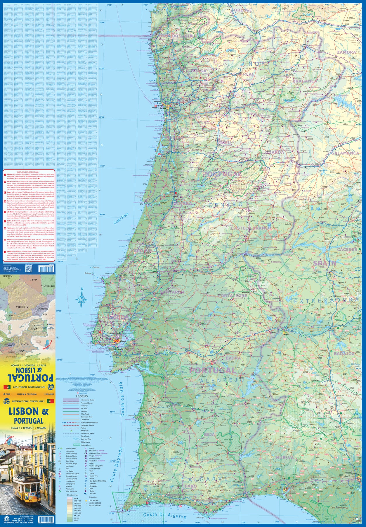
Portugal
Ordinær pris 199,00 krITM har kart over hele verden og de spesialiserer seg på land litt utenfor allfarvei. Beliggenheten til landets nasjonalparker, historiske monumenter, de viktigste veiene o.L. Finner du inkludert i kartene. Samtlige landkart har ofte et bykart over hovedstaden.
Fra ITM: We are very pleased to be able to release a double-sided detailed map of Portugal. Although we have included the country in previous maps, it was always as an adjunct to another map (Spain and Portugal, Portugal and Southern Spain etc.), so it is high time that this very nice popular country had its own ITM map. Being a long, rather thin country, Side 1 concentrates on Lisbon and the southern half of Portugal with a detailed inset map of Lisbon. It also includes the Spanish provinces of Huelva and Badajoz. Side 2 covers the northern half of the country along with portions of neighbouring Spanish provinces. As a country, Portugal has a wealth of touristic attractions and we have included as many as we can on this map without cluttering it – castles, palaces, fortresses, cathedrals and churches, dozens of museums, beaches, a few hotels, mines, monuments, and just about everything a visitor would want to have. Of course, motorways, highways, secondary routes, rail lines, ferry services, and geographic heights of land are also included; altogether, a fabulous map for a wonderful country.
Publisert år: 2025
Innbinding: falset
Material: Papir
Målestokk: 1:500,000
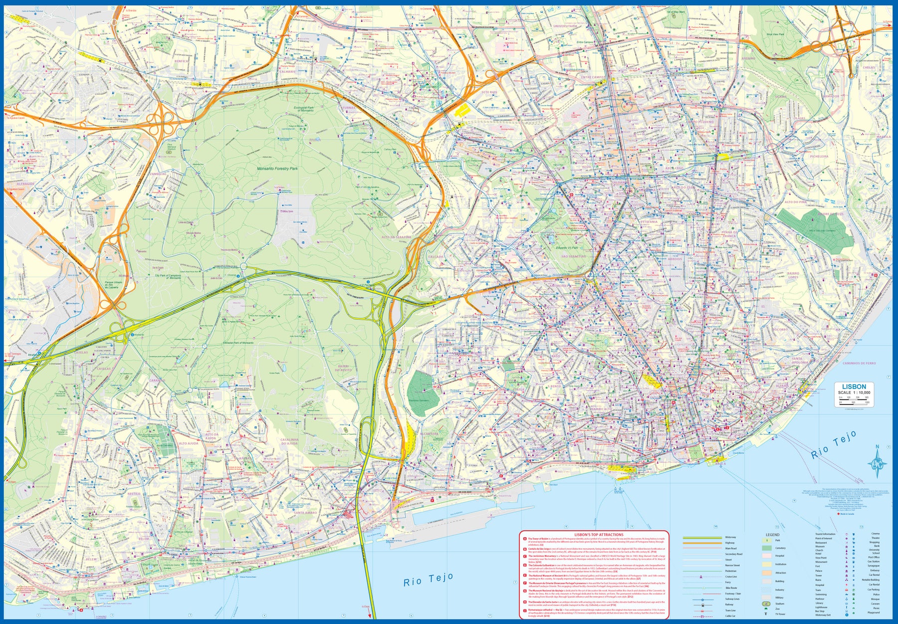
Portugal: Lisbon & Portugal
Ordinær pris 199,00 krThe city of Lisbon is one of the most attractive in Europe. It is an ancient city, but most of its architecture dates from the Victorian era. It has a fascinating number of tram lines, and the trams tend to be an experience worth the trip. One graces our cover. There is no cheaper way to explore this city than to climb aboard and let the rails decide your destination!
Coverage extends from the northern and western motorways to the southerly Rio Tejo and the national museum, so shows the city quite comprehensively. Almost half of the map area is of the massive Monsanto Park, one of the largest urban parks in the world. The reverse side is equally important, in that it presents our first-ever map dedicated to showing the charms of the entire country of Portugal. A bit of western Spain is included due to the unevenness of the border, but the map goes from the northernmost tipoff Castelo to the southernmost expanse of the Costa Do Algarve, showing touristic attractions, historic sites, beaches, museums, rail connections, and major parks.
The map is printed on waterproof stone paper, a recent technological innovation that is gradually replacing plastic.
Puerto Rico & Virgin Islands
Ordinær pris 169,00 krITM har kart over hele verden og de spesialiserer seg på land litt utenfor allfarvei. Beliggenheten til landets nasjonalparker, historiske monumenter, de viktigste veiene o.L. Finner du inkludert i kartene. Samtlige landkart har ofte et bykart over hovedstaden.
Fra ITM: The American territories of Puerto Rico and the US Virgin Islands are anomalies in the modern world, neither fish nor fowl, as the saying goes. Although the residents are American citizens, they have no representation in Congress and are not allowed to vote in national elections. The lesser-known British Virgin Islands are included on this double-sided map. The BVI is still a British colony, consisting of about 20 islands, capitaled in Road Town (inset included). Puerto Rico (1:190.000) is a large, rectangular island, capitaled by San Juan (inset included) and is a major cruise ship point of origin as well as being home to resort communities all over the main island. Ferries connect to outlying islands. The VI portion was purchased from Denmark in 1917 and retains a colonial European charm. There are three main islands – St. Croix, St. Thomas, and St. John – and the map includes inset maps of Charlotte Amalie, Cruz Bay, Christiansted, and Frederiksted. Each side of the map sheet includes a listing of top attractions. Ferry routes to the BVI are shown, as well as water connections between the islands. Virgin islands 1:85.000.Legend Includes:Roads by classification, Rivers and Lakes, National Park, Airports, Points of Interests, Highways, Main Roads, Zoos, Fishing, and much more...
Publisert år: Aug. 2021
Innbinding: falset
Material: vanntet tpapir
Målestokk: 1:190000/1:85,000
Rhine River Cruising
Ordinær pris 199,00 krThe Rhine River flows from the Gletch Glacier in the Swiss Alps north to central Germany and then on to Amsterdam and the North Sea. It has been a major transportation link in Europe for many centuries, with dozens of castles located at strategic points. Today, it is a peaceful touristic haven as well as a busy working river, with dozens of shallow-draft boats wending their way around countless turns in the river. It is probably the busiest tourist highway in Europe. This double-sided map starts in Amsterdam, where it is known as the Waal, and follows the course of the river inland past Nijmegen to the German border, where the name changes to Rhine. There are many notable interesting cities along its route, such as Essen in the Ruhr Valley, Dusseldorf, Koln, with its magnificent cathedral, Bonn, Castle Arenfels, Koblenz, and Rüdesheim, where it joins the Main River and heads east to Frankfurt-on-Main and points east. As a map is a rectangular sheet of paper and a river is a narrow portion wending its way as geography takes it. This is much more than a simple river map. It is a detailed portrayal of a very interesting part of Europe, extending far beyond the banks of the river, and is ideal for those travelling by car, by train, or by river boat. A detailed city centre map of Frankfurt is included.
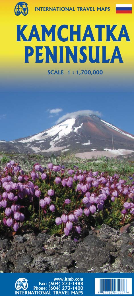
Russia: Kamchatka Peninsula
Ordinær pris 169,00 krITM har kart over hele verden og de spesialiserer seg på land litt utenfor allfarvei. Beliggenheten til landets nasjonalparker, historiske monumenter, de viktigste veiene o.L. Finner du inkludert i kartene. Samtlige landkart har ofte et bykart over hovedstaden.
Fra ITM: This is the most recently released title of our Russia series. In this revised edition, we have expanded the area of coverage to include the portion of Russia known as the Far East Republic and the eastern portions of Siberia (in January, we released Siberia itself). Lets start with the Kamchatka peninsula itself. This is a very interesting adventure travel destination, famous for its geothermal geysers and its isolation from the rest of Russia. There is only city of any size, Petropavlovsk Kamchatsky (which I genuinely hope is colloquially known as PK), the capital and location of the peninsulas only significant airport. We have included an inset map of the city. We also include a map of the famous Valley of Geysers (South of Klyuchi). Interestingly, the peninsula has a town called Esso. The other side of the sheet portrays a vast region from the Russian occupied island of Sakhalin and the Okhotsk Sea north to that portion of what we call the Arctic Ocean but is really a series of seas (this one being the East Siberian Sea) and west to the Lena River. The Trans Siberian railway west towards Moscow is shown, as well as connections into Mongolia and China. This is not a well known region of Russia and is definitely for the adventurer (I would to hear from anyone who has stayed at the hotel in Novaya Chara, which is as close to being the middle of nowhere I can imagine. actually, this portion of Russia is loaded with hotels and camping grounds. The map also shows a fascinating road going from close to the border with China all the way to a bay on the ocean. That would be quite a trip to take!
Publisert år: 2022
Innbinding: falset
Material: papir
Målestokk: 1:700,000
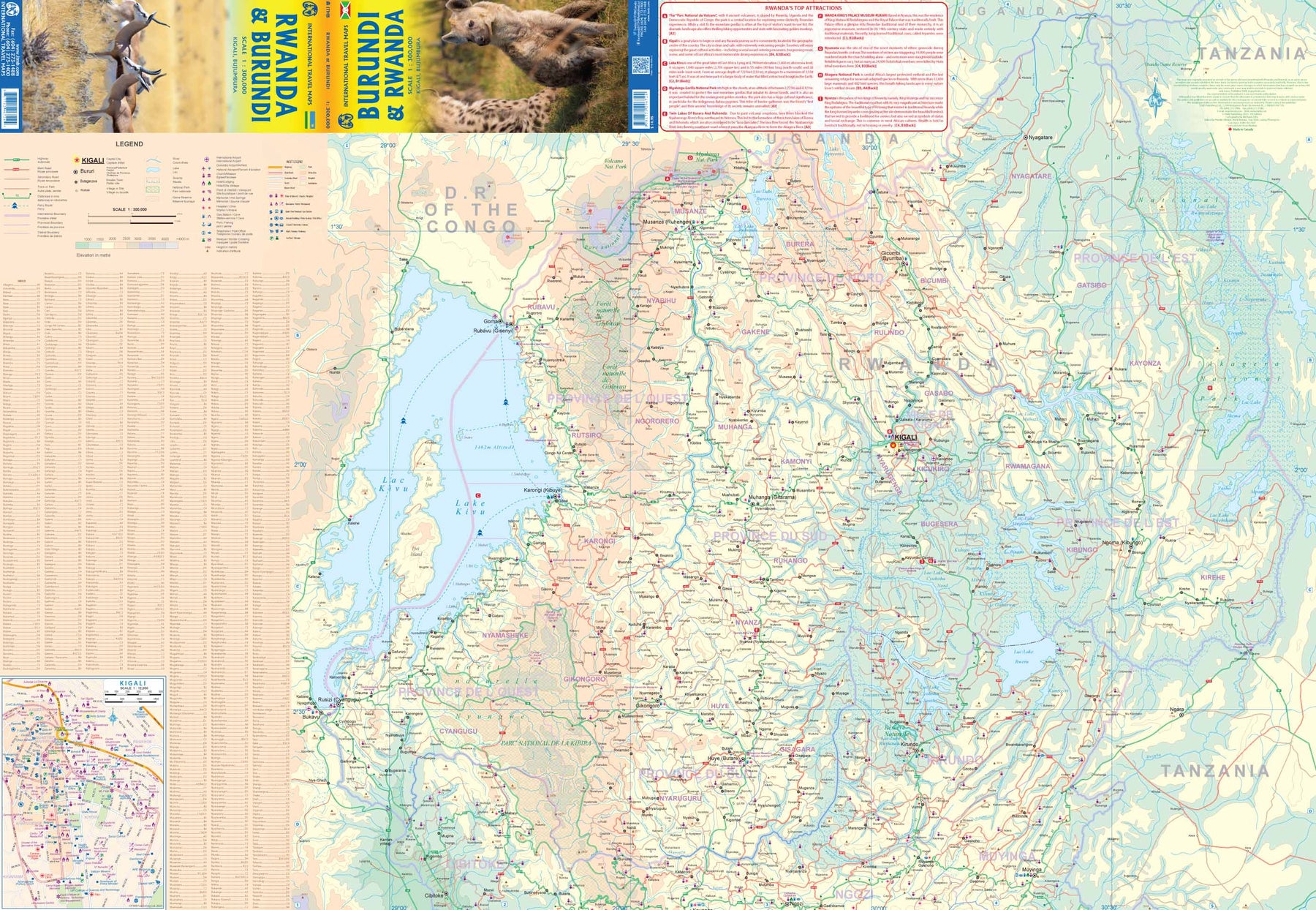
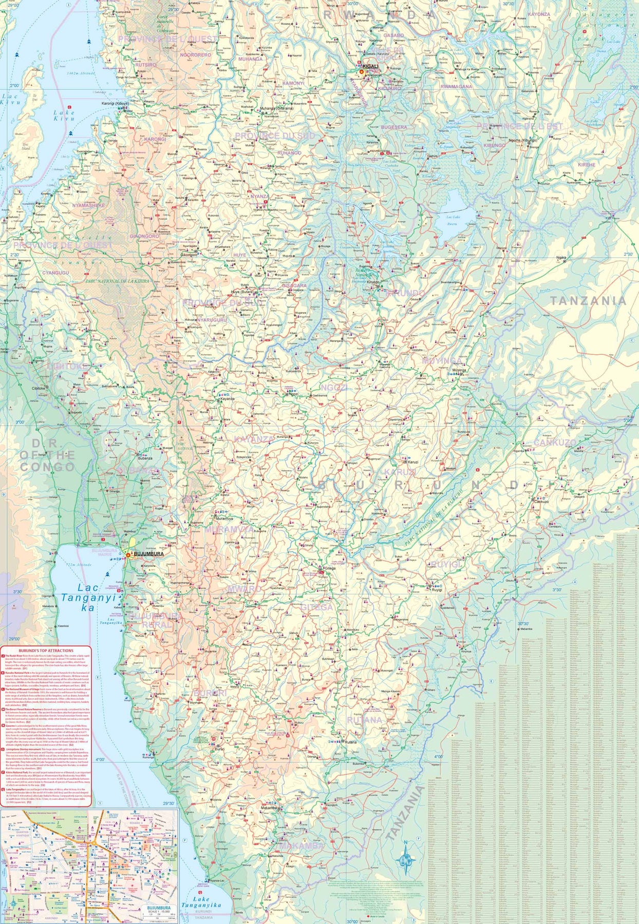
Rwanda & Burundi
Ordinær pris 199,00 krITM har kart over hele verden og de spesialiserer seg på land litt utenfor allfarvei. Beliggenheten til landets nasjonalparker, historiske monumenter, de viktigste veiene og lignende finner du inkludert i kartene. Samtlige landkart har ofte et bykart over hovedstaden.
Saint Lucia & Martinique
Ordinær pris 149,00 krITM har kart over hele verden og de spesialiserer seg på land litt utenfor allfarvei. Beliggenheten til landets nasjonalparker, historiske monumenter, de viktigste veiene og lignende finner du inkludert i kartene. Samtlige landkart har ofte et bykart over hovedstaden.
Fra ITM: Saint Lucia in 1:45.000 and Martinique in 1:65.000. We have included an inset map of Castries, the capital, noting, among other things, the cruise ship terminals (there are two) and the inter-island ferry terminal. That is important because St. Lucia is now linked to neighbouring Martinique by a scheduled ferry service and it is very convenient for visitors wishing to enhance their visit by adding a day trip to Martinique. For this reason, we have added a full-page map of Martinique to the reverse side of the sheet. The ferry goes to Fort-de-France, the capital, and the map includes an inset of the city, showing where the ferry docks. Martinique, with its French heritage, is more exotic than most English-speaking Caribbean countries, but is friendly and somehow different.
It is considered an extension of France and thus of the European Union, so uses the Euro. Although the common language is French (or a variety of it), English is well-understood. Cars are readily available for hire and road conditions are good. The island even boasts a motorway, going to the island’s south coast. Both islands are important Caribbean travel destinations, with resort hotels concentrated on Marigot Bay and Rodney Bay in St. Lucia and in the Pont du Bout peninsula of Martinique. The map has a double-sided cover for ease of marketing.
Sierra Leone & Freetown
Ordinær pris 199,00 krITM har kart over hele verden og de spesialiserer seg på land litt utenfor allfarvei. Beliggenheten til landets nasjonalparker, historiske monumenter, de viktigste veiene o.L. Finner du inkludert i kartene. Samtlige landkart har ofte et bykart over hovedstaden.
Fra ITM: The West African country of Sierra Leone is one of the hidden gems of Africa. A relatively stable and peaceful country, it moved into independence easily. English remains the common language of communication, which is nice. The only urban area of any size in the country is the Capital, Freetown. The name dates from the time of the American Revolution, where slaves who fought for the British army were given sanctuary far from the rebellious whites determined to re-enslave them. Rather than having a Top Attractions list, we have devoted a considerable amount of space on the country side to note its history and points of interest. Side 2 is a detailed map of Freetown, with an inset map of the nearby Peninsula Mountains. Freetown boasts the largest natural harbour in the world and has a 500-year-old Cotton tree in its town centre. This is definitely a country worth visiting!
Publisert: 2025
Innbinding: falset
Material: papir
Målestokk: 1:500,000/1:13,000