275 produkter
275 produkter


275 produkter
Great Britain: England - Southeast & Midlands Railway & Road
Ordinær pris 199,00 krThe shape of the UK makes it difficult to map logically. The term South East, within crowded England, is generally more restrictive than is appropriate for a map. Our definition of SE is from the English Channel north to the northern tip of East Anglia and west to Portsmouth/Reading/Peterborough. This occupies side one of the sheet. Side two consists of that complex portion of England generally called ‘The Midlands’ stretching from Cambridge/Peterborough west to the Welsh border and from Luton/Gloucester north to Manchester/Grimsby. London is, of course, prominent, but only as a main roads map.
This is the most recent sectional map of the UK that ITMB has published, and was necessitated by the realization that, to see England properly, one needs a detailed enough map to show rail lines, motorways, A-type highways and B-type secondary roads, but also the tertiary level of road joining villages. The road network of England is incredibly complex and cannot be shown in proper detail without mapping at this scale or better. England also has a sophisticated rail network and this is left off most maps to avoid clutter. We have emphasized all the rail lines carrying passengers, which makes the London portion look like a spaghetti factory, but there are lines everywhere. All motorways and highways are shown, but rail lines are prominently shown, to encourage travel by train. A Top Attractions list has been included as well, but hundreds of interesting touristic sites have been included.
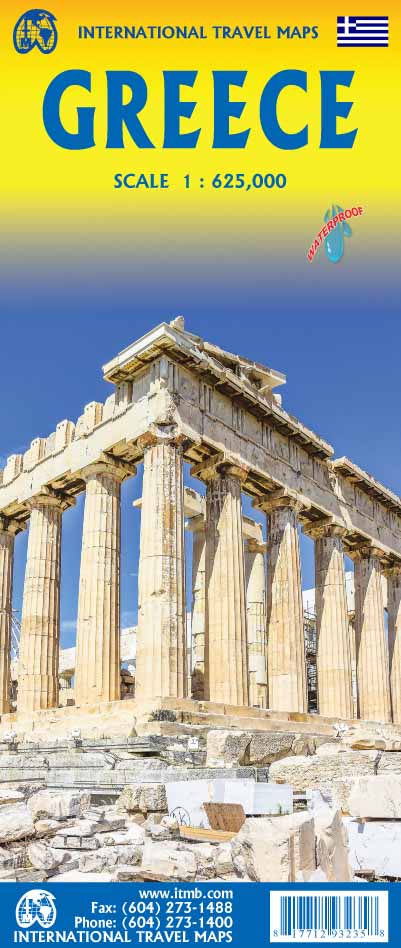
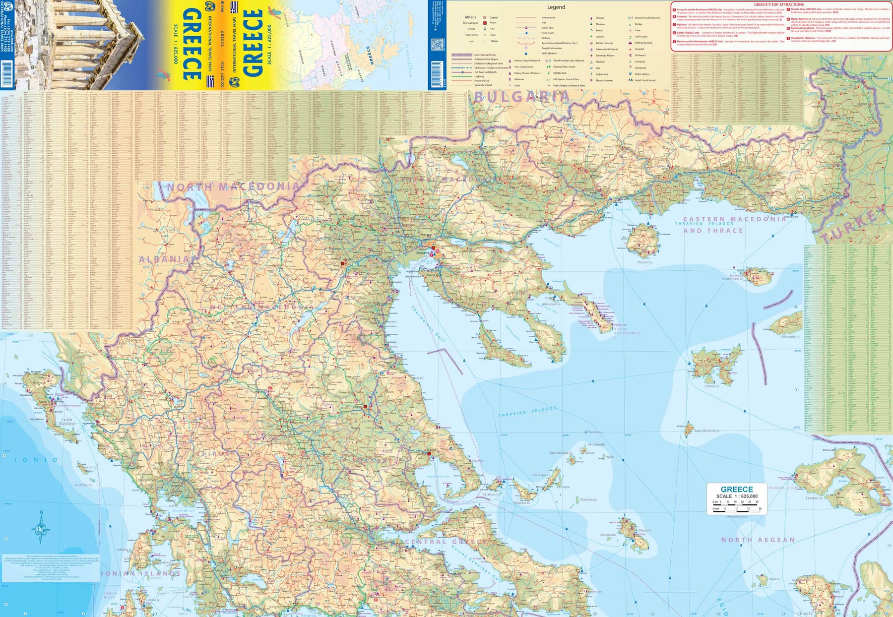
Greece
Ordinær pris 199,00 krGreece is one of the most important touristic destinations in the world. We have travelled the country extensively and have undertaken a serious upgrading of information for this edition. As a country, Greece divides naturally into three portions - the area around Athens and the Peloponnese, the far north region centred on Thessalonica, and the marvellous islands scattered around the southern portion of Greece.
This is an overall map, showing the latest road information and noting historic and cultural sites of interest to visitors, including world heritage sites. An inset map of Athens is included, but ITMB's map of the city would be useful for those exploring Athens in detail. We also published an expanded map of the Peloponnese, and another of Crete and Mykonos.
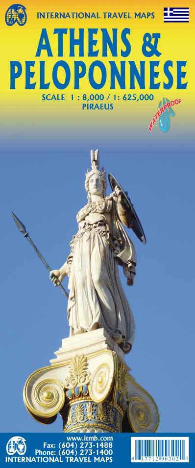
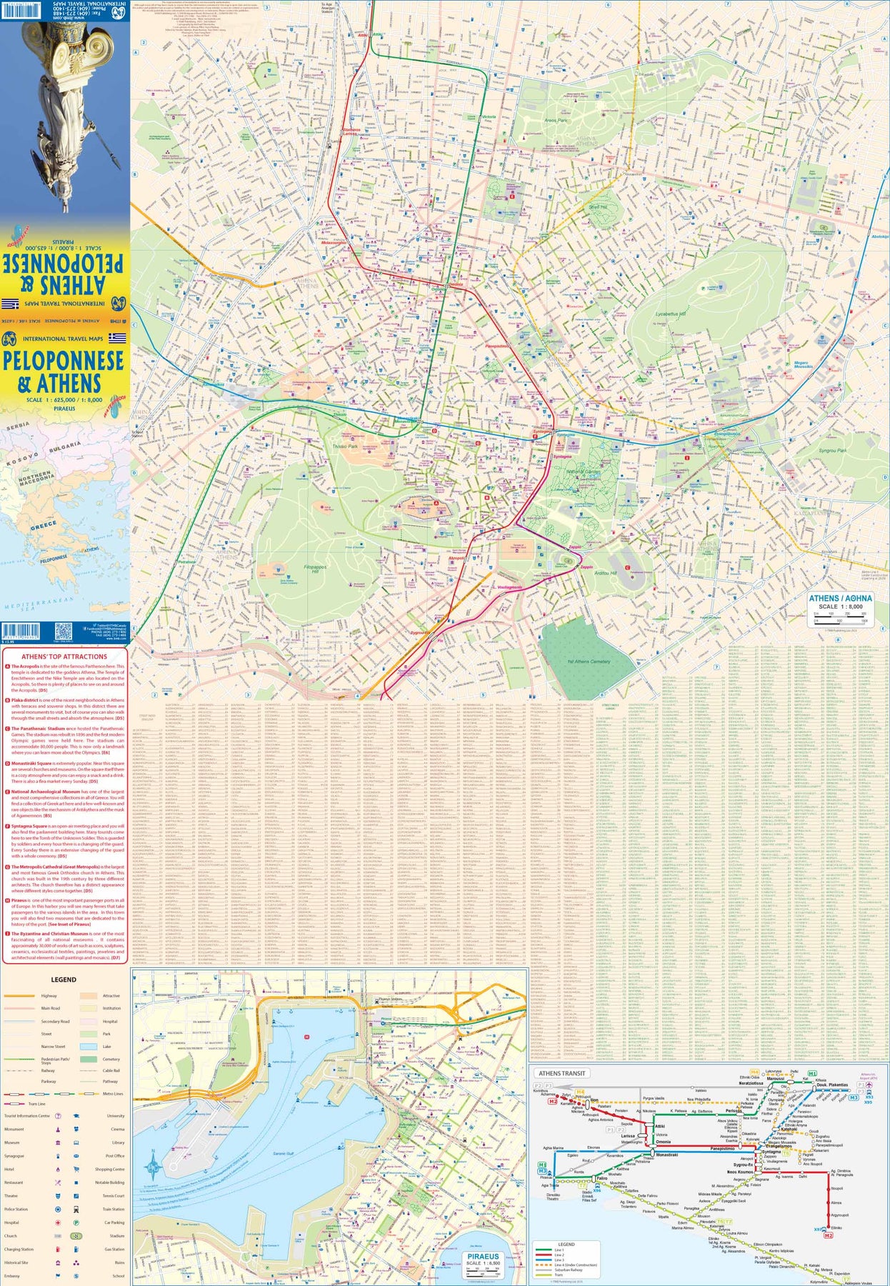
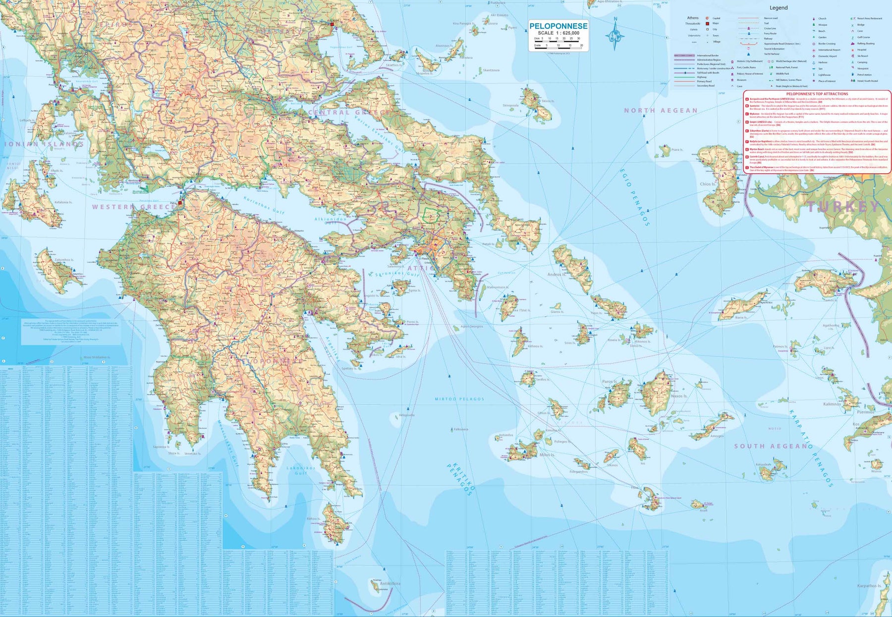
Greece: Athens & Peloponnese
Ordinær pris 199,00 krAthens is one of the most ancient and historic cities in the world. The Acropolis is the mountain upon which rests the Temple Athena, often called the Parthenon as it dominates the terrain. There are two other ancient temples on the Acropolis as well. Close by is the Agora, the ancient city market centre, and at the foot of the Acropolis are two open-air theatres that date back to ancient times. Athens is also a modern city with congested roads, vibrant stores, and an excellent underground transit system. Included with Side 1 is a map of Piraeus, the nearby port city, with its many terminals for ferries leading to the various Greek islands. It is also one of the most active cruise ship terminals in the world, operating from Terminals A through C. A regional transit map is also included.
Side 2 concentrates on the peninsula (technically an island) west of Athens called the Peloponnese that is the home to Olympus, Sparta, and other former city states of legendary fame, and many of the Greek islands that are relatively close to Athens - Many of The Cyclades for example. By the shape of Greece, Delphi and much of Epirus is included. Altogether, this provides one map covering city and its hinterland for the benefit of the end user.
Greece: Crete; Mykonos & Santorini
Ordinær pris 169,00 krThe many islands off the coast of Greece can only be mapped properly a few at a time. Side 1 of this map shows the large island of Crete in good detail, with the relatively nearby island of Mykonos and its adjacent island of Rinia and the island of Santorini, with its adjacent islands of Thirasia and Nea Kameni being shown in great detail. A locality map showing the islands in relation to the rest of Greece is included as an inset. It is our intention to map more islands as time passes, but this depends upon future research trips (we lead a hard life!).
Side 2 of the map is a general map of Greece in relation to its neighbours to the north and east. The Mediterranean is divided into smaller seas, such as the Adriatic along the coast of Croatia, the Ionian to the west of Greece, the Myrtoan to its south and the Aegean to its east. All this area is replete with islands and geopolitical conflicts. As such, this map is useful for showing the region as an entity that links the Balkan states to the eastern Mediterranean.
Greenland & North Pole
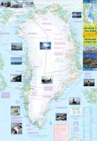
Ordinær pris 179,00 krGreenland is indeed a fascinating place to visit. Granted, much of it consists of inaccessible Icefields that, if they melted, would detrimentally raise ocean levels to catastrophic levels. The coastal regions are, however, inhabited, and it is possible to fly in or take an adventuresome cruise with Linblad and visit the giant island. Three-quarters of Greenland lies above the Arctic Circle and ice bergs carved out of the many slowly-moving rivers of ice are commonplace in the North Atlantic. Due to sea ice, the notable attractions of the island tend to be concentrated in the southern third.
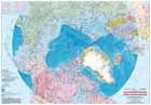
The original settlers are not the Norse, but Inuit peoples who migrated eastwards from what is now Canada’s northland. Although the area has been a Danish possession for centuries, only the relatively narrow Nares Strait separates it from Canada’s Ellesmere Island, and the famous Thule Air Force base is considerably south of Alert, Nunavut. The second side of the sheet is a separate map of the entire North Polar Region, centred on the true North Pole itself.
The Polar Region consists of everything north of the Arctic Circle, but this map extends the concept southward to the 55th parallel, thereby including all of Scandinavia, including Denmark, as well as all of northern Canada, northern Russia, Greenland, Iceland, Alaska, and even Scotland, Estonia, and Latvia. A tiny portion of Ireland and a goodly chunk of Belarus also fall into the range of this map, which is very interesting, and is unique. No other such map exists. It was prepared by the Canada Map Office as a project and is used here with permission. Believe it or not, as a result, this map is copyright by the Queen, as are all government maps produced in Canada. I think that’s a nice touch for an international map! Being a circular projection, the printing is from Canada at the ‘bottom; thus, the place names for Russia and Scandinavia are oriented from the perspective of a wall map. In other words, nomenclature is consistently downwards, not circular, so if the map is rotated, Russian place names would be upside down.
The significance of this map cannot be understated. It is the only one ever prepared as a survey-specific quality of every nation on earth that could consider itself ‘polar’. Its scale prevents undue detail, but we have noted a short series of trivia points of note, such as the difference between true north and the magnetic pole, or the largest urban area in the region (Murmansk), or the location of the most northerly known thermal hot spring (Alaska). The urban area closest to the North Pole is Alert, at the top end of Canada’s Ellesmere Island, at about the 83rd parallel. Both these maps are so interesting that they are easy sells. The cover is double-sided, so can be presented on retail shelves either with Greenland outwards, or North Pole outwards. Either way, it sells. Enjoy!
Guadeloupe & Dominica
Ordinær pris 169,00 krITM har kart over hele verden og de spesialiserer seg på land litt utenfor allfarvei. Beliggenheten til landets nasjonalparker, historiske monumenter, de viktigste veiene o.L. Finner du inkludert i kartene. Samtlige landkart har ofte et bykart over hovedstaden.
Fra ITM: The country of Guadeloupe (1:110.000) actually consists of six islands, with the main island being divided by a narrow peninsula into Basse-Terre and Grand-Terre. It is a French possession, so uses the Euro as its currency. The other touristic island is Marie-Galante, which one reaches by ferry from the capital city of Pointe-a-Pitre. The only airport is north of the capital, and touristic access is through it, or via the regular ferry from Dominica. Obviously, the lingua franca is French, and the towns have exotic-sounding names like Petites-Anses, Grand-Bourg, or Le Moule. Touristic resorts exist, but are scattered, unlike the complexes in Mexico. The road network is more basic, but reasonably comprehensive, and the significance of the country is that of a Caribbean European enclave combining the best of both continents. The other side of the map consists of a detailed map of Dominica (1:50.000), a popular cruise ship stop-over. The capital is Roseau, and an inset map is included. Beach resort enclaves exist south of the city, but what Dominica offers that varies from most other Caribbean islands is a well-developed network of inland resorts to explore the jungle-like mountainous parts of the island.
Publisert år: 2019
Innbinding: falset
Material: Papir
Målestokk: 1:110000/1:50000
Guam & West Pacific Cruising
Ordinær pris 169,00 krWe are very pleased to be (finally) able to publish the first travel map of the island of Guam. Certainly, this is the only map of Guam by any major cartographic publishing house. Here are some details: Guam is a north-south island considerably north of New Guinea, and forms part of the American-held group of islands known as the Northern Marianas. Its capital is Hagatna, and the main town is called Tamuning. The island has a well-developed international airport in the middle portion of the island, with a large US military airbase in the northeast corner. The vast majority of the island is touristic, and well worth a visit. The island was "discovered" by Ferdinand Magellan in 1521, and Hagatna is the oldest "European" city in the Pacific, dating from 1686. The town of Inarajan retains a decidedly Spanish appearance to this day. Other attractions include Tumon Beach and its many resorts, the Piti Underwater Observatory, and the famous Cocos Island dive wall.
This is a double-sided map, with the Western Pacific Cruising map gracing the second side of the page. This side covers several island entities, and stretches from Australia in the south to Japan in the north and as far to the east as Hawaii and the Cook Islands, so includes such popular cruise destinations as Fiji, Tonga, New Caledonia, the Solomons, Papua, Samoa, Kiribati, and the Marshall Islands. It makes a lovely wall map!
Indonesia
Ordinær pris 149,00 krITM har kart over hele verden og de spesialiserer seg på land litt utenfor allfarvei. Beliggenheten til landets nasjonalparker, historiske monumenter, de viktigste veiene o.L. Finner du inkludert i kartene. Samtlige landkart har ofte et bykart over hovedstaden.
Fra ITM: A map of Indonesia, which offers an overall view of this vast archipelago, over 700 islands. It also shows all sea links between the different îslands, the traveler can move from island to island. Scale 1:2,4 mill. The legend includes: The various roads, airports, seaport, hiking, national park, nature reserve, wildlife sanctuary, marine reserve, Beach, Water sports, Fishing, Coral Sand Volcano, Monument and more. 5th edition 2018.
Publisert år: 2018
Innbinding: falset
Material: Plastpapir
Målestokk: 1:2400000
Italy: Florence & Italy Northeast
Ordinær pris 199,00 krFlorence, or Firenze in Italian, is one of the most fascinating cities on earth. It is a treasure trove of museums, statues, plazas, narrow streets, and expensive stores. Lan and I spent a week here last December, representing Canada at an international convention. We had our artwork ready to go to press, but we wanted one last opportunity to check our data. It proved to be a wise decision. We found many changes that were unrecorded-hotels out of existence, restaurants either closed down or open with new names, many churches closed, and others converted to other uses, two tram lines not shown on other maps, and lots of disruption caused by the advent of Omicron, which seems like it has been here forever instead of just a few months.
The Florence side covers from the fortress north of the main railway station to south of the Bobolini Park and from the Hippodrome east to the Asics Firenze Sports complex, and all at an easy-to-use 1:5,000 scale on waterproof paper. The rapid transit lines, which extend to the airport and the regional bus lines off the map, are clearly shown. Dozens upon dozens of hotels, restaurants, churches, plazas, statures, and important buildings are noted, as well as quite a few grocery stores, bars, electric bike recharging stations, bus stops, museums, theatres, bike routes, and libraries.
This map was exhaustive to research! The reverse side is a map of much of central Italy. We call it the Northeast because it starts in Trieste and follows the northern border to Milan, then goes down to Genoa and on to Pisa, Siena, Perugia, and Viterbo. Motorways are shown in purple, with main roads in red. Top attractions are noted. Thus, one can enjoy Florence and take day trips using the same convenient map!
Italy: North & Central - Veneto; Umbria & Tuscany
Ordinær pris 199,00 krItaly: Sicily & Italy South
Ordinær pris 179,00 krITM har kart over hele verden og de spesialiserer seg på land litt utenfor allfarvei. Beliggenheten til landets nasjonalparker, historiske monumenter, de viktigste veiene og lignende finner du inkludert i kartene. Samtlige landkart har ofte et bykart over hovedstaden.
Although this is a title that ITMB has marketed for several years, it should count as a brand new map in that the artwork is now our own and the map includes a second side focused on southern Italy. The Sicily side concentrates on the infrastructure and touristic sites of the island itself, along with the southern tip of the Italian mainland, showing ferry crossings. Sicily has a rich history, with Greek and well as Roman remains to explore and Mount Etna to visit if it isn't erupting. The Valley of the Temples, south of Agrigento, is particularly worth seeing. The second side concentrates on that portion of Italy from Pescara in the far north to Naples, the Amalfi Coast, to Potenza all the way to Brindisi and Taranto (the 'heel' of the boot). The 'toe' of the boot is on side 1. The focus of this map is on Sicily, but as most access to the island is via the mainland, we think combining the two meets most visitor's needs.
Italy: Sicily; Sardinia & The South
Ordinær pris 169,00 krITM har kart over hele verden og de spesialiserer seg på land litt utenfor allfarvei. Beliggenheten til landets nasjonalparker, historiske monumenter, de viktigste veiene og lignende finner du inkludert i kartene. Samtlige landkart har ofte et bykart over hovedstaden.
Italy: South & Central
Ordinær pris 179,00 kr