Filter
- Afghanistan
- Albania
- Algerie
- Andorra
- Angola
- Argentina
- Armenia
- Aserbajdsjan
- Australia
- Bahamas
- Bahrain
- Bangladesh
- Barbados
- Belgia
- Benin
- Bolivia
- Bosnia-Hercegovina
- Botswana
- Brasil
- Brunei
- Bulgaria
- Burundi
- Canada
- Chile
- Colombia
- Costa Rica
- Danmark
- Djibouti
- Dominica
- Ecuador
- Egypt
- Ekvatorial-Guinea
- El Salvador
- Eritrea
- Estland
- Eswatini
- Etiopia
- Fiji
- Filippinene
- Finland
- Frankrike
- Gabon
- Georgia
- Ghana
- Guyana
- Hellas
- Honduras
- Hviterussland
- India
- Indonesia
- Irak
- Irland
- Island
- Israel
- Italia
- Jamaica
- Japan
- Jemen
- Jordan
- Kambodsja
- Kamerun
- Kenya
- Kina
- Kirgisistan
- Komorene
- Kongo
- Kosovo
- Kroatia
- Kypros
- Latvia
- Lesotho
- Libanon
- Libya
- Liechtenstein
- Litauen
- Luxembourg
- Madagaskar
- Malawi
- Malaysia
- Maldivene
- Mali
- Malta
- Mauritania
- Mexico
- Monaco
- Mongolia
- Montenegro
- Mosambik
- Nauru
- Nederland
- Nepal
- New Zealand
- Nicaragua
- Niger
- Nigeria
- Nord-Korea
- Nord-Makedonia
- Norge
- Oman
- Pakistan
- Panama
- Papua Ny-Guinea
- Paraguay
- Peru
- Polen
- Portugal
- Qatar
- Romania
- Russland
- Rwanda
- Samoa
- Serbia
- Seychellene
- Sierra Leone
- Singapore
- Slovakia
- Slovenia
- Solomonøyene
- Somalia
- Spania
- Sri Lanka
- Storbritannia
- Sudan
- Surinam
- Sveits
- Sverige
- Syria
- Sør-Afrika
- Sør-Korea
- Sør-Sudan
- Taiwan
- Tanzania
- Togo
- Tonga
- Tsjekkia
- Turkmenistan
- Tyskland
- Uganda
- Ukraina
- Ungarn
- Uruguay
- USA
- Usbekistan
- Vanuatu
- Venezuela
- Vietnam
- Zimbabwe
- Østerrike
315 produkter
315 produkter

Mexico: Chihuahua & Coahuila
Ordinær pris 169,00 kr/
Mva inkludert
Frakt beregnes i kassen.
ITM har kart over hele verden og de spesialiserer seg på land litt utenfor allfarvei. Beliggenheten til landets nasjonalparker, historiske monumenter, de viktigste veiene o.L. Finner du inkludert i kartene. Samtlige landkart har ofte et bykart over hovedstaden.
Fra ITM: Northern Mexico is a vast desert-like plateau deeply steeped in Spanish colonial heritage. The very first settlement inside what is now the USA was the town of Presidio (long before the English thought of settling Jamestown) and is still one of the few crossings of the Rio Grande into Texas (itself a former Mexican province). There are two major cities in the region, Chihuahua, 300 kms south of El Paso, and Monterrey, the largest city in northern Mexico. There are major touristic attractions at Monclova, Saltillo, Parras, Torreon, and Cuauhtemoc, the end of the famous Copper Canyon rail line. The map extends a bit into Sinaloa, to include Los Mochis on the Pacific coastline. The entire rail line is also shown. This is an important part of North American history. It may not be as well-known to Europeans who favour the beaches of the Yucatan, but it is a fascinating part of Mexico on the American border. Ciudad Juarez, for example, is larger than its partner on the Rio Grande, El Paso. An inset map of the old colonial city of Saltillo is included, as well as our Top Attractions list.
Publisert år: 2022
Innbinding: falset
Material: papir
Målestokk: 1:750000


France: French Atlantic Coast - Rail & Bike
Ordinær pris 179,00 kr/
Mva inkludert
Frakt beregnes i kassen.
France is a rather large country, and while it can be portrayed on a map as a country, mapping it in segments provides an opportunity to concentrate on regions at a better scale. This map, covering the coastal region of France from the Cotenin Peninsula south to the Spanish border and east as far as Paris and Montpellier in Languedoc is the first of what we hope will be a series covering the country at an improved scale. This map is double-sided, covering from Quimper and Paris at the northernmost portion of coverage, to Angouleme and Clermont at the southern extreme on one side, with the second side covering from Bordeaux and St-Etienne south to Bayonne/Pamplona and Nimes/Avignon in the south. This is a part of Europe that has been fought over for centuries, and as such is dotted with fortresses proclaiming its historic importance.
This map has been designed with the leisure traveller in mind. Although it shows all motorways and highways, rail connections by train are emphasized, as are long-distance Euro-Velo cycling routes that are being developed in many parts of Europe. At this scale, it would be impractical to record all accommodations, but we have included a new feature that is thus far peculiar to France, and that is motorway hotels at rest areas. Naturally, the map is rich with places of touristic interest.
- Publisert: 2022
- Utgave: 1. utgave
- Vanntett materiale
- Målestokk: 1:600 000
- ISBN: 9781771292887

USA: Texas & Oklahoma
Ordinær pris 149,00 kr/
Mva inkludert
Frakt beregnes i kassen.
ITM har kart over hele verden og de spesialiserer seg på land litt utenfor allfarvei. Beliggenheten til landets nasjonalparker, historiske monumenter, de viktigste veiene o.L. Finner du inkludert i kartene. Samtlige landkart har ofte et bykart over hovedstaden.
Fra ITM: Increasingly, we are developing our artwork to cover the larger states attractively and comprehensively, but also, we hope sensibly. Texas and Oklahoma share a common heritage of having been formed out of land taken from others through the long-held policy of Manifest Destiny. Today, Texas is the second largest State in the union (after Alaska), and is the only State to have previously been an independent country. It also includes the oldest urban area in the USA, Presidio, founded by the Spaniards to guard the ford over the Rio Grande. Because of its shape, and the natural proximity of the State of Oklahoma along its northern edge, combining the two States just made sense. The map is presented double-sided (top half/bottom half) on waterproof paper that is durable and tear-resistant. There was not as much room for inset maps as we had hoped, but good-sized urban map of Amarillo, Tulsa, and Oklahoma city are included. The map has two covers, one for each State, for easier display; both States are done at the same scale.
- Publisert: 2016
- Innbinding: Falset
- Materiale: Plastpapir
- Målestokk: 1:1 300 000

USA: Seattle & Washington State
Ordinær pris 199,00 kr/
Mva inkludert
Frakt beregnes i kassen.
The actual area of the map includes Portland and northern Oregon and Vancouver and the border area with the USA. A small portion of Idaho is also shown. Wilderness campsites, parks such as Rainier, Olympic, and Baker, are shown. Seattle as a city, stretches far beyond the confines of a practical map in that it stretches from Everett to Tacoma. Our map covers from the University in the north to the Beacon hill neighbourhood in the south and from the waterfront to Lake Washington.
An inset map of the greater region is included. The rapid transit line is also included on the map and on the back cover. The reverse side of the sheet shows all the roads of Washington State in excellent Olympic, and Baker, state parks, touristic sites, beaches, ferry routes, native reserves, motorways, and even the ill-fated Hanford nuclear site are included. The map is printed on ITM waterproof paper for durability.
- Publisert: 2020
- Innbinding: Falset
- Materiale: Vannfast papir
- Målestokk: 1:12 500, 1:700 000

Panama: Panama Canal & Central
Ordinær pris 169,00 kr/
Mva inkludert
Frakt beregnes i kassen.
ITM har kart over hele verden og de spesialiserer seg på land litt utenfor allfarvei. Beliggenheten til landets nasjonalparker, historiske monumenter, de viktigste veiene og lignende finner du inkludert i kartene. Samtlige landkart har ofte et bykart over hovedstaden.
Fra ITM: One of the world's great travel adventures is sailing through the Panama Canal, which we did last year (see cover photo). Panama itself is a large enough country that the canal, which is visited annually by millions of passengers, cannot be shown in meaningful detail. So, whether one is on board one of the many cruise ships squeezing into the Miraflores Locks or are a visitor ashore watching, the canal is a great attraction. The map is double-sided, with central Panama (the part most visited) filling side one. Side two is divided in half along the central fold. A very detailed map of Panama City fills the left side, and the first-ever map of the canal itself fills the other. This is a marvelously portrayed rendition of the most important canal in the world. Even at this scale, the locks themselves are thin lines on the sheet, but they're there.
Publisert år: 2020
Innbinding: falset
Material: vanntett papir
Målestokk: 1:100,000 / 300,000


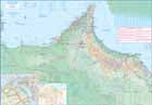
New Zealand: South Island
Ordinær pris 199,00 kr/
Mva inkludert
Frakt beregnes i kassen.
ITM har kart over hele verden og de spesialiserer seg på land litt utenfor allfarvei. Beliggenheten til landets nasjonalparker, historiske monumenter, de viktigste veiene o.L. Finner du inkludert i kartene. Samtlige landkart har ofte et bykart over hovedstaden.
Fra ITM: New Zealand is a very popular travel destination. ITMB publishes a map of the entire country and two detailed maps at a better scale of the North and the South Islands. South Island is somewhat larger than the more populous North, and includes several offshore small island entities, such as the Chatham Islands and the South Auckland Islands off the coast of Antarctica. The main city is Christchurch, for which a detailed street plan has been included on the map. The ferry route to Wellington (on North Island) is also shown.
Publisert: 2025
Innbinding: falset
Material: vanntettpapir
Målestokk: 1:600,000


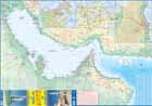
United Arab Emirates & Gulf Cruising
Ordinær pris 169,00 kr/
Mva inkludert
Frakt beregnes i kassen.
ITM har kart over hele verden og de spesialiserer seg på land litt utenfor allfarvei. Beliggenheten til landets nasjonalparker, historiske monumenter, de viktigste veiene og lignende finner du inkludert i kartene. Samtlige landkart har ofte et bykart over hovedstaden.
From ITMB: The Gulf, in this case, is the Persian Gulf, or if you prefer, the Arabian Gulf or, if you wish to, the Iranian Gulf. Regardless of which name one prefers, it is the body of water between Iran and the Arabic Emirates of Bahrain, Qatar, Dubai, and Oman/Muscat. It is also a popular cruising locale, with ships operating from Dubai to various ports of call. It also covers a considerable amount of geography, so side 1 concentrates on the water area from Kuwait/Iraq/Iran south to Bahrain and Qatar, along the coastline of the UAE to Oman and the Straits of Hormus, and along the coast of Oman to Muscat. It also includes inset maps of Manama (Bahrain), and Doha (Qatar), for the convenience of users. The second side of the map shows all of the United Arab Emirates and most of Oman, with insets of central Dubai and Muscat. Each side includes a listing of the top attractions of the side being shown. This is the third of ITMB’s growing range of cruising maps. We believe that the future of travel includes cruises as a popular means of exploring exotic travel destinations while retaining a comfortable environment. My wife and I cruised the Gulf a couple of years ago and found cruising to be an excellent way to explore several different countries that would be difficult to reach in any other manner. One day, I hope that cruises in this part of the world will extend to ports of call in Kuwait, Iraq, and Iran.
- Publisert: 2021
- Innbinding: Falset
- Materiale: Vanntett papir
- Målestokk: 1:1 500 000, 1:900 000


USA: Grand Canyon & Arizona
Ordinær pris 169,00 kr/
Mva inkludert
Frakt beregnes i kassen.
Arizona is an amazingly attractive State to visit, with Route 66 attractions in the north, bustling Phoenix in the centre, and a strongly-influenced Mexican influence in the south. Thus, a travel map for the state makes sense, and this one shows camping sites, local attractions (including Tombstone) and includes inset maps for Flagstaff and Grand Canyon Village. Its main attraction, however, is Grand Canyon, a deep defile carved out over millennia by the Colorado River, on its way to the Gulf of Mexico. This is one of nature's wonders, and a "must see" for everyone.
This results in a very interesting and useful map, covering both one of the most interesting States in America AND one of the great natural phenomena of the world. The map is printed on waterproof and biodegradable stone paper, which is a technological marvel in its own right, in this case for durability rather than to protect against moisture.
- Publisert: 2022
- Innbinding: Falset
- Materiale: Vannfast papir
- Målestokk: 1:90 000, 1:1 000 000

Great Britain: England - Southeast & Midlands Railway & Road
Ordinær pris 199,00 kr/
Mva inkludert
Frakt beregnes i kassen.
The shape of the UK makes it difficult to map logically. The term South East, within crowded England, is generally more restrictive than is appropriate for a map. Our definition of SE is from the English Channel north to the northern tip of East Anglia and west to Portsmouth/Reading/Peterborough. This occupies side one of the sheet. Side two consists of that complex portion of England generally called ‘The Midlands’ stretching from Cambridge/Peterborough west to the Welsh border and from Luton/Gloucester north to Manchester/Grimsby. London is, of course, prominent, but only as a main roads map.
This is the most recent sectional map of the UK that ITMB has published, and was necessitated by the realization that, to see England properly, one needs a detailed enough map to show rail lines, motorways, A-type highways and B-type secondary roads, but also the tertiary level of road joining villages. The road network of England is incredibly complex and cannot be shown in proper detail without mapping at this scale or better. England also has a sophisticated rail network and this is left off most maps to avoid clutter. We have emphasized all the rail lines carrying passengers, which makes the London portion look like a spaghetti factory, but there are lines everywhere. All motorways and highways are shown, but rail lines are prominently shown, to encourage travel by train. A Top Attractions list has been included as well, but hundreds of interesting touristic sites have been included.
- Publisert: 2020
- Innbinding: Falset
- Materiale: Vanntett papir
- Målestokk: 1:300 000

Dominica & Saint Lucia
Ordinær pris 149,00 kr/
Mva inkludert
Frakt beregnes i kassen.
ITM har kart over hele verden og de spesialiserer seg på land litt utenfor allfarvei. Beliggenheten til landets nasjonalparker, historiske monumenter, de viktigste veiene o.L. Finner du inkludert i kartene. Samtlige landkart har ofte et bykart over hovedstaden.
Fra ITM: The island is a popular holiday vacation destination and cruise ship stopover port. We have in reality placed two maps on the sheet, by adding St. Lucia, another popular Caribbean destination, to the reverse side. Each country is placed on one side of the paper, with insets of their respective capitals, Roseau and Castries. Dominica, with its rugged volcanic terrain, its dominating mountains, and its lush pristine rainforests, has a natural beauty that is a prime reason to visit and enjoy the island’s attractions.
In addition, both islands are linked to each other and to Martinique and Guadeloupe by new inter-island ferries. This new system of ferries is joining the islands together for sharing tourism, as well as economic cohesion within the Caribbean. It is now possible to base oneself on Dominica and enjoy day trips to Martinique, for example, or St. Lucia.
Publisert år: 2013
Innbinding: falset
Material: vanntett papir
Målestokk: 1:50,000 / 40,000


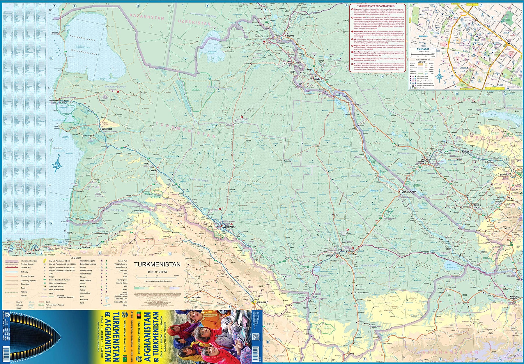
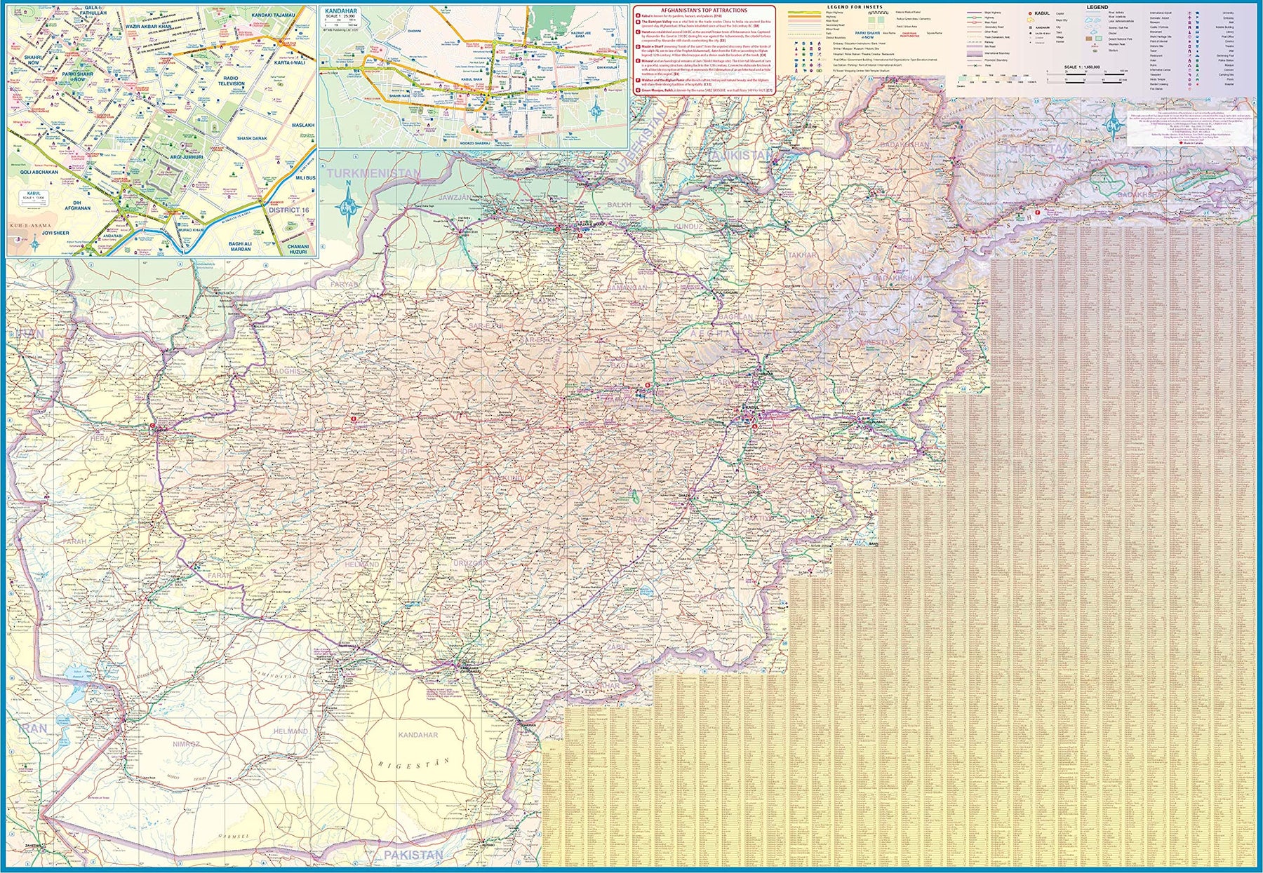
Turkmenistan & Afghanistan
Ordinær pris 179,00 kr/
Mva inkludert
Frakt beregnes i kassen.
The world is changing as a result of a global pandemic, and ITMB has to change with it. We wish to keep all of our artwork available, but at a time of greatly reduced travel, we have been forced to combine two different countries that share a common border in order to justify printing either one. The two countries, Afghanistan and Turkmenistan, do share a common heritage, but a very different history. ITMB Publishes a separate map of the country, and a map of Kabul. The reason for this map is that it is our first ever map of just Turkmenistan, a former part of the USSR that broke away in the collapse of the Russian empire in 1990. The country has, however, not emerged from the Soviet way of thinking, and is authoritarian in its attitude. It is, fortunately, open to travel, and is slowly improving its facilities, so is to be encouraged.
The map includes a very good inset map of Ashgabat, the capital. The country stretches from the Caspian Sea to the Uzbek border and from Russia south to Iran and Afghanistan. We have also added eight Top Attractions, ranging from the World Heritage site of Konye to the ancient ruins of Nisa. We previously published this titles as part of a regional map of the ‘Stans’, but growing demand has justified its own map. We have also published a separate map of Uzbekistan and a separate three-country map of the other three countries, all of which are showing strong signs of touristic development. Turkmenistan is a country emerging as a future travel Mecca. Legend Includes: Roads by classification, Rivers and Lakes, National Park, Airports, Points of Interests, Highways, Main Roads, Zoos, Fishing, and much more...
- Publisert: Aug. 2021
- Innbinding: Falset
- Materiale: Vanntett papir
- Målestokk: 1:1 350 000, 1:650 000

Paraguay & Bolivia South
Ordinær pris 199,00 kr/
Mva inkludert
Frakt beregnes i kassen.
ITM har kart over hele verden og de spesialiserer seg på land litt utenfor allfarvei. Beliggenheten til landets nasjonalparker, historiske monumenter, de viktigste veiene og lignende finner du inkludert i kartene. Samtlige landkart har ofte et bykart over hovedstaden.
Fra ITM: Expanding the area of coverage benefits visitors combining Paraguay and Bolivia into one trip. The first side covers Bolivia from La Paz south to the Paraguayan border, with inset maps of Potosi and Santa Cruz. The second side concentrates on Paraguay itself, with inset maps of Asuncion, the Asuncion region, and northern Paraguay. Small bits of bordering countries also are included. Road connections within Paraguay have been shown to good advantage. Both countries, being land-locked, are somewhat isolated, making travel to them something more adventuresome than visits to neighbouring countries. However, both are hospitable, safe, and tourist-friendly.
Inkl. bykart over: Asunción.
- Publisert: 2019
- Innbinding: Falset
- Materiale: Vanntett papir
- Målestokk: 1:1,000,000 / 1:390,000