2208 produkter
2208 produkter


2208 produkter
706 France: North-West
Ordinær pris 169,00 krMichelin er en av verdens beste, og best kjente, kartserier. Kartene har glimrende kartografi.
785 Australia
Ordinær pris 169,00 krMichelin er en av verdens beste, og best kjente, kartserier. Kartene har glimrende kartografi.
766 Canada
Ordinær pris 169,00 krLonely Planet Lake District & Cumbria
Ordinær pris 119,00 kr
Lonely Planet Planning Map er slitesterkt og vanntett, med en hendig slipcase og et format som er enkelt å brette. Få mer ut av kartet og reisen din med bilder og informasjon om toppattraksjoner i landet, reiseruteforslag, en transportguide, planleggingsinformasjon, temalister og praktiske reisetips. Med dette brukervennlige navigasjonsverktøyet i baklommen kan du virkelig komme til hjertet av din destinasjon!
Mallorca: Serra de Tramuntana
Ordinær pris 399,00 krThis set of 4 maps covers the Tramuntana Mountains in northern Mallorca, at a scale of 1:25 000. The 4 maps show all the main walking and hiking trails in the Tramuntana Mountains, with a generous overlap between each map.
Also shown across all 4 maps is the whole of the GR 221 long distance walking trail.
France: South Rail & Bike
Ordinær pris 199,00 krThis is a brand new title for ITMB and an attempt to portray a changing travel landscape in a mapping format. Eco-tourism is a rapidly growing activity, with enormous potential. At the same time, governments are seeking to reduce carbon pollution by encouraging train travel, so ITMB is climbing aboard the movement by publishing a map encouraging train travel while still retaining the road network and noting all the long-distance bike routes in southern France by designated number.
This is, by its scale, a generalized map of that portion of France south of Poitiers or Lyon to the Mediterranean, so is more of a regional map showing biking opportunities than a detailed trail map. Nevertheless, it is an excellent map on waterproof paper showing cycling routes and tertiary roads that are suitable for recreational exploration. Naturally, motorways and main highways are shown as well. Legend Includes: Roads by classification, Rivers and Lakes, National Park, Airports, Points of Interests, Mining, Highways, Main Roads, Zoos, Fishing, , and much more...
CK22 Danmark
Ordinær pris 299,00 krNyrevidert, detaljert veikart med kilometeravstander og nummererte motorveikryss. Naturskjønne veier er uthevet. Bornholm, Læsø og Anholt er innfelt som egne kartutsnitt. Eget kartutsnitt Stor-København. Registerhefte innlimt i omslaget.
France: Corsica
Ordinær pris 199,00 krCorsica at 1:135,000 on an indexed road map with topographic and tourist information printed on light, waterproof and tear-resistant synthetic paper. The map, published by Reise Know-How as part of their highly acclaimed World Mapping Project, is double-sided to provide the best balance between a good scale and a convenient size sheet, and shows the island with a generous overlap between the two sides.
Topography is indicated by altitude colouring plus spot heights and plenty of names mountain groups, peaks and other geographical features. Boundary of the Parc Naturel Régional de Corse and other protected areas are highlighted. Road network includes small local roads and selected 4WD tracks, gives driving distances on main routes, and prominently indicates scenic routes. The map also shows the course of the island’s famous long-distance trail, the GR20. Also included are railway lines and ferry connections. Symbols highlight numerous places of interest, including campsites and mountain huts, UNESCO world heritage and archaeological sites, recreational facilities and areas, beaches, etc. The map has a UTM grid plus latitude and longitude lines at intervals of 5’, is indexed, and its map legend includes English.
Uganda
Ordinær pris 219,00 krIndexed, waterproof and tear-resistant road map of Uganda with topographic and tourist information, published by Reise Know-How as part of their highly acclaimed World Mapping Project. The map is double-sided to provide the best balance between a good scale and a convenient size sheet.
The country’s topography is presented by altitude colouring with contours, spot heights, mountain passes, and names of mountain and hill ranges or plateaux. Swamps and seasonal rivers are also marked. Internal administrative boundaries are shown with names of regions and provinces. Road network includes unsurfaced local roads or tracks and shows driving distances on most roads, locations of petrol stations and border crossings. Railways, local airfields and ferry routes on Lake Victoria and Lake Albert are also shown.
National parks and protected zones are clearly marked. Symbols highlight numerous places of interest, including UNESCO world heritage and archaeological sites, hotels and lodges, camping sites, hot springs, rock paintings, viewpoints, etc. The map has a latitude and longitude grid at intervals of 30’ and index of localities. Map legend includes English.
Italy: Sardinia
Ordinær pris 199,00 krIndexed, waterproof and tear-resistant road map of Sardinia at 1:200,000 with topographic and tourist information, published by Reise Know-How as part of their highly acclaimed World Mapping Project. The map is double-sided, with a good overlap, to provide the best balance between a good scale and a convenient size sheet.
Topography is indicated by altitude colouring with spot heights and names of mountain ranges. Road information includes local tracks, indicates driving distances on main and secondary roads, and highlights scenic routes. Railways and ferry connections are also shown. Extensive overprint indicates locations of numerous nuraghi/nuraghes, the main type of megalithic edifices found in Sardinia, dating back before 1000 BC and today a symbol of the island’s distinctive culture. The overprint also highlights local national parks, holiday camps, campsites and mountain refuges, viewpoints, prehistoric monuments, churches and castles, beaches, golf courses, etc. The map has a 10km UTM grid, plus latitude and longitude grid at 10’ intervals. Map legend includes English.
Barcelona
Ordinær pris 159,00 krLet the Marco Polo city map of Barcelona guide you around this awe-inspiring city. Highly durable and waterproof, this handy, pocket-size Barcelona map folds away easily and is always on standby to help when you're stuck.
Provence & French Riviera (Alps)
Ordinær pris 199,00 krLet the Marco Polo Provence, Alps, Cote d’Azur Road Map guide you around this beautiful region of southern France. Discover the glamour of the Cote D’Azur, the glittering sea, the glorious resorts and charming towns with this highly durable, detailed, touring map of the French Riviera with this highly durable, detailed touring map. It folds away easily and is always on standby to help when you're stuck. Perfect touring map - the scale is 1 : 275 000 ideal to help you tour the country by car or campervan.
714 Benelux - Belgium; Luxembourg & Netherlands
Ordinær pris 169,00 krMichelin er en av verdens beste, og best kjente, kartserier. Kartene har glimrende kartografi.
542 Germany Northeast
Ordinær pris 169,00 krMichelin er en av verdens beste, og best kjente, kartserier. Kartene har glimrende kartografi.
720 Poland
Ordinær pris 169,00 krMichelin er en av verdens beste, og best kjente, kartserier. Kartene har glimrende kartografi. Rød serie, kalt “national”. Dekker et enkelt land eller en gruppe land primært med hovedferdselsårer.
523 France: Rhône-Alpes
Ordinær pris 169,00 krMichelin er en av verdens beste, og best kjente, kartserier. Kartene har glimrende kartografi.
Publisert: Jan 2023
Innbinding: falset
Material: papir
Målestokk: 1:200,000
519 France: Bourgogne (Burgundy)
Ordinær pris 169,00 krMichelin er en av verdens beste, og best kjente, kartserier. Kartene har glimrende kartografi.
357 Italia: Emilia-Romagna
Ordinær pris 169,00 krSri Lanka & India South
Ordinær pris 199,00 krThis edition is a considerable improvement on our previous one, benefitting from the extensive research trip we took to the emerald-shaped island shortly before the outbreak of Covid changed the world. We have re-introduced it as a map printed on waterproof paper, as such a format holds up well in a hot, humid climate. We visited all parts of the island and were quite impressed by the number of local hotels and resorts that we found and have added to the map. We were particularly gratified to discover progress on extending the motorway system for the country, much of it now probably delayed due to Covid.
The inset map of Colombo is particularly well-done. The second side of the sheet is a very detailed map of the southern third of India, from Nagpur to the southern tip of the country. Space constraints did not allow for inset maps, but several well-known cities are included – Mumbai, Hyderabad, Chennai, Pondicherry, Madurai, and Bengaluru (Bangalore) among them. India is a fascinating, if somewhat intimidating, place to visit, but is well-worth the time to do so.
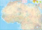
Africa
Ordinær pris 199,00 krAfrica is a huge continent. No one apart from us has successfully prepared a digital data base for the entire continent and this edition includes numerous updates to road information and shifting political realities. We have updated roads whenever reliable data indicates improvements, such as connections between the southern tip of Morocco and the road leading to Nouakchott, in Mauritania. Politically, we all know of things that do not affect maps - the closed border between Algeria and Morocco, the coup in Guinea, the continued instability of Libya, the generally better degree of stability in Somalia, the on-going troubles in South Sudan - but generally, the continent of 54 nation states and a few colonial enclaves has survived two years of destabilizing Covid ravages rather well. Tourism is gradually recovering, and map sales improving.
This is a very important map in that it brings all of the countries and islands relative to the African continent into perspective. We are pleased to bring to your attention an updated version of a part of the world that is crucially important.
3054 Hardangervidda Sørvest
Ordinær pris 259,00 krNorway: North
Ordinær pris 199,00 kr6028 Hardangervidda
Ordinær pris 249,00 krOpplevelsesguide Hardangervidda tar for seg rundturen fra Oslo via Hallingdal til Sørfjorden og tilbake via Haukeli og Kongsberg, med avstikkere til Rjukan, Numedal og Eggedal. Kartet har 98 attraksjoner/severdigheter/aktiviteter, noen eksempler er: Munchs hus, Tropicana badeland, Rallarvegen, Trolltunga, Vigelandsparken, Holmenkollen, Vøringsfossen og Heine Onstad kunstsenter.
6023 The South West Coast
Ordinær pris 249,00 krOpplevelsesguide The South West Coast tar for seg strekningene fra Jæren og Stavanger via Haugesund til Bergen, fra Stavanger gjennom Ryfylke og Hardanger til Voss og Bergen og strekningen over til Setesdal, opp til Haukeli og over til Røldal. Kartet har 114 attraksjoner/severdigheter/aktiviteter, noen eksempler er: Preikestolen, Vøringsfossen, Voss Vind, Vitengarden, Fløibanen, Vitengarden, Høse bru, Trolltunga, Edvard Grieg Museum Troldhaugen.
3034 Finnskogen Nord
Ordinær pris 259,00 krTopo 3000 er et detaljert kart som dekker over 3000 km2. Finnskogen er et variert landskap på begge sider av grensen mellom Norge og Sverige. Her finner man både gamle kulturminner fra den skogfinske kulturen, vill natur og et rikt dyreliv. Finnskogen er også perfekt for fiske, padling, fugletitting og terrengsykling. Toppen Flotsberget er et populært turmål og ca. 1000 personer bestiger toppen hvert år. Turen er litt bratt men ikke krevende og passer for hele familien. Kartet inneholder finske stedsnavn.
Her finner du turer som: Topptur til Vardåsen (fra Kirkenær) 5,8 km, Sætervandring til Skålbergsætra 3,5 km, Fottur langs flyktningeruta Spiker’n mot Sverige 38,6 km. Eksempel på hytter: Finnskogen turist- og villmarkssenter (betjent), Hansekoia, Helgedammen (ubetjente).
3033 Finnskogen Midtre
Ordinær pris 259,00 kr3031 Børgefjell
Ordinær pris 259,00 kr2607 Fjordruta
Ordinær pris 259,00 krTurkartserien til Nordeca er laget i samarbeid med Den Norske Turistforeningen (DNT) og inneholder DNTs stier, hytter og annen nyttig turinformasjon. Enkelte av kartene har også skiløyper.
Kystnær vandrerute med en variasjon fra fjære til høyfjell. Utsikt over tinderekka fra Trollheimen til Romsdalsfjell den ene veien og utover havet den andre veien. Flere av etappene går i landskap som er barnevennlig. Du kan starte ved terminalen på Kvernberget Lufthavn i Kristiansund. Fra 1997 er det tatt i bruk 13 selvbetjente hytter. Det er seterbuer, stabbur samt en hytte som er restaurert og åtte er nybygg.
Kartet dekker Nordmøre, Surnadal, Trollheimen, Tustna og Kristiansund.