Filter
- Andorra
- Angola
- Argentina
- Aserbajdsjan
- Australia
- Bangladesh
- Belgia
- Belize
- Benin
- Bolivia
- Bosnia-Hercegovina
- Brasil
- Brunei
- Bulgaria
- Burundi
- Canada
- Chile
- Costa Rica
- Cuba
- Danmark
- Djibouti
- Ecuador
- El Salvador
- Eritrea
- Estland
- Eswatini
- Etiopia
- Finland
- Frankrike
- Ghana
- Guyana
- Hellas
- Honduras
- Hviterussland
- India
- Indonesia
- Irak
- Iran
- Irland
- Island
- Israel
- Italia
- Jamaica
- Jordan
- Kambodsja
- Kasakhstan
- Kenya
- Kina
- Kirgisistan
- Kongo
- Kosovo
- Kroatia
- Kypros
- Laos
- Latvia
- Lesotho
- Libanon
- Libya
- Litauen
- Luxembourg
- Malawi
- Malaysia
- Mali
- Marokko
- Mauritania
- Mexico
- Montenegro
- Mosambik
- Namibia
- Nederland
- Nepal
- New Zealand
- Nicaragua
- Niger
- Nigeria
- Norge
- Pakistan
- Panama
- Paraguay
- Peru
- Polen
- Portugal
- Romania
- Russland
- Rwanda
- Samoa
- Serbia
- Sierra Leone
- Singapore
- Slovakia
- Slovenia
- Somalia
- Spania
- Sri Lanka
- Storbritannia
- Surinam
- Sveits
- Sverige
- Sør-Korea
- Taiwan
- Thailand
- Togo
- Tsjekkia
- Tunisia
- Turkmenistan
- Tyskland
- Uganda
- Ungarn
- USA
- Usbekistan
- Venezuela
- Vietnam
- Zimbabwe
- Østerrike
2208 produkter
2208 produkter
Utsolgt
Cycling Atlas Europe
219,00 kr
Utsolgt
The World
199,00 kr
Utsolgt
Life on Svalbard
429,00 kr
Utsolgt
Alsace by bike
179,00 kr

Thailand
Ordinær pris 279,00 kr/
Mva inkludert
Frakt beregnes i kassen.
This beautifully illustrated Thailand guidebook is perfect for travellers planning longer trips. Written by Insight Guides' travel experts, it combines in-depth coverage of history, culture, and must-visit places with the visual appeal of an illustrated magazine. Stunning photos inspire excitement for those planning their journey.
They also offer a captivating read for armchair travelers looking for a taste of Thailand from home. In this Thailand travel guidebook, you will find:- Top attractions handpicked by our editors - must-visit highlights including Bangkok, Similan Islands Marine National Park, Nakhon Ratchasima (Khorat) Province, Ayutthaya, Chiang Mai, Phuket, Krabi, Sukhothai, showcasing the very best of what Thailand has to offer- In-depth coverage of attractions - detailed narratives on iconic sites and hidden gems, all organized by geographical location- Best time to visit Thailand - expert guidance on the ideal seasons to go, with insights into climate, festivals, and peak vs. off-peak travel- Practical travel information - essential advice on logistics, including getting there, moving around, budgeting tips, dining and shopping- Insider recommendations - top tips on avoiding crowds, saving money, and discovering the best local spots- Engaging essays - thought-provoking features on Thailand's history, culture, contemporary life, and politics for a deeper understanding- High-quality maps - detailed, numbered maps highlighting must-see places, perfectly aligned with the text- Striking pictures - breath-taking images on every page to inspire your journey- Easy navigation with color-coded chapters - unique colours for quick reference.
- Publisert: Okt. 2025
- Utgave: 19. utgave
- Antall sider: 384
- Innbinding: Heftet
- Språk: Engelsk
- ISBN: 9781839054419

Berlin
Ordinær pris 279,00 kr/
Mva inkludert
Frakt beregnes i kassen.
And this Berlin travel guidebook is printed on paper from responsible sources, and verified to meet the FSC's strict environmental and social standards. This Berlin guidebook covers: Unter den Linden and around, Museum Island and around, Alexanderplatz and around, The Spandauer Vorstadt, Potsdamer Platz and Tiergarten, City West and Schoneberg, Kreuzberg-Friedrichshain, Prenzlauer Berg and around, The eastern suburbs, The western suburbs and Out of the city. Inside this Berlin travel book, you'll find: - A wide range of sights - Rough Guides experts have hand-picked places for travellers with different needs and desires: off-the-beaten-track adventures, family activities or chilled-out breaks- Itinerary examples - created for different time frames or types of trip- Practical information - how to get to Berlin, all about public transport, food and drink, shopping, travelling with children, sports and outdoor activities, tips for travellers with disabilities and more- Author picks and things not to miss in Berlin - Insider recommendations - tips on how to beat the crowds, save time and money, and find the best local spots- When to go to Berlin - high season, low season, climate information and festivals - Where to go - a clear introduction to Berlin with key places and a handy overview - Extensive coverage of regions, places and experiences - regional highlights, sights and places for different types of travellers, with experiences matching different needs.
forfattere: Paul sullivan
Publisert måned: juni 2024
Utgave: 12.utg
Sider nr: 336

Jordan
Ordinær pris 279,00 kr/
Mva inkludert
Frakt beregnes i kassen.
This Jordan guidebook is perfect for independent travellers planning a longer trip. It features all of the must-see sights and a wide range of off-the-beaten-track places. It also provides detailed practical information on preparing for a trip and what to do on the ground.
- Publisert: November 2024
- Utgave: 8. utgave
- Antall sider: 400
- Innbinding: Heftet
- Språk: Engelsk
- ISBN: 9781835290606

Albania & North Macedonia
Ordinær pris 199,00 kr/
Mva inkludert
Frakt beregnes i kassen.
The ideal map for your trip. Let the Marco Polo Croatia Road Map guide you around this fascinating region of eastern Europe. Discover one of Europe's most beautiful coastlines with this highly durable, detailed, touring map of Croatia which also covers most of the Balkans. It folds away easily and is always on standby to help when you're stuck.
- Publisert: 2025
- Innbinding: Falset
- Materiale: Papir
- Målestokk: 1:450 000

Jordan Highlights
Ordinær pris 249,00 kr/
Mva inkludert
Frakt beregnes i kassen.
Discover the enchanting charm of Jordan with Bradt's compact Jordan Highlights, your perfect guide to this fascinating country's top sites. This guide whets your appetite for some of the world's most remarkable experiences. Travel from the ancient city of Jerash, through the lively markets of Amman, and experience the stunning landscapes of Wadi Rum.
Enjoy the best of Jordan's attractions, including the impressive Petra and its lesser-known companion, Little Petra. Delve into the depths of the Gulf of Aqaba, bob like a cork in the turquoise waters of the Dead Sea, and float over the stunning scenery of Wadi Rum in a hot-air balloon. Walk in the footsteps of Popes Benedict and John Paul at Mount Nebo, to the spot where Moses is believed to have seen the promised land.
Journey to the sacred Baptism Site, "Bethany Beyond the Jordan," which has essential importance in the Bible as the place where John baptized Jesus. Lastly, admire the 6th-century Madaba Map in Madaba, an intriguing depiction of the Holy Land from the Byzantine era. The guide's Practicalities section provides indispensable information on getting to Jordan and travelling around the country. Discover the enchanting charm of Jordan with Bradt's compact Jordan Highlights, your perfect guide to this fascinating country's top sites. This guide whets your appetite for some of the world's most remarkable experiences. Travel from the ancient city of Jerash, through the lively markets of Amman, and experience the stunning landscapes of Wadi Rum.
- Publisert: Okt. 2024
- Utgave: 1. utgave
- Antall sider: 176
- Innbinding: Heftet
- Språk: Engelsk
- ISBN: 9781804692257

807 Albania
Ordinær pris 169,00 kr/
Mva inkludert
Frakt beregnes i kassen.
Michelin er en av verdens beste, og best kjente, kartserier. Kartene har glimrende kartografi.
- Publisert: 2024
- Innbinding: Falset
- Materiale: Papir
- Målestokk: 1:260 000

Lonely Planet Czech Phrasebook & Dictionary
Ordinær pris 99,00 kr/
Mva inkludert
Frakt beregnes i kassen.
It's all about confidence. This book will give you all the practical phrases you need to explore the countryside, visit Golden Prague, and tour castles and mountains worthy of the Brothers Grimm (in fact, the 2005 movie of that name was filmed here). It also contains all the fun phrases you need to connect with local people and get a better understanding of the country and its culture.
Never get stuck for words with our 3500-word two-way dictionary Order the right meal with our menu decoder Avoid embarrassing situations with essential tips on culture & manners Coverage includes: Basics, Practical, Social, Safe Travel and FoodLonely Planet gets you to the heart of a place. Our job is to make amazing travel experiences happen. We visit the places we write about each and every edition.
We never take freebies for positive coverage, so you can always rely on us to tell it like it is. Authors: Written and researched by Lonely Planet and Richard Nebesky. About Lonely Planet: Started in 1973, Lonely Planet has become the world's leading travel guide publisher with guidebooks to every destination on the planet, as well as an award-winning website, a suite of mobile and digital travel products, and a dedicated traveller community.
- Publisert: Juli 2025
- Utgave: 5. utgave
- Antall sider: 256
- Innbinding: Heftet
- ISBN: 9781788688024

Slovenia & Istria
Ordinær pris 199,00 kr/
Mva inkludert
Frakt beregnes i kassen.
Marco Polo Slovenia and Istria Map: the ideal map for your trip. Let the Marco Polo Slovenia and Istria Road Map guide you around this stunning region. It folds away easily and is always on standby to help when you're stuck. Perfect touring map - the scale is 1 : 250 000 ideal to help you tour the country by car or campervan. Easy to use - the superbly clear mapping in strong colours and easy to read text will help you navigate the country like a local. Durable, tear-resistant map - designed to withstand the rigors of the road, the map is printed on tear-resistant, water repellent and writeable paper. Highlights included - major sights and key points of interest are marked on the map by numbered stars.
- Publisert: 2023-2025
- Innbinding: Falset
- Materiale: Papir
- Målestokk: 1:250 000

Kefalonia
Ordinær pris 229,00 kr/
Mva inkludert
Frakt beregnes i kassen.
Kefalonia was popularised and made famous by Captain Corelli's Mandolin. For your best adventures, use the best map. Water-proof, split-proof, tear-proof, adventure-proof.
Kefalonia and Ithaca Tour and Trail Super Durable Map is simply the toughest, most accurate, easy to read, easy to use map of the island you can buy at any price. A large 960mm by 690mm double sided map sheet has both Kefalonia and Ithaca at 1:40,000 scale with the North-West of Kefalonia on the cover side and the South-East of Kefalonia with neighbouring island Ithaca on the reverse. A generous common overlap of Kefalonia reduces the need to turn the map over when navigating.
Our special concertina map fold makes your map easy to open and easy to refold to its 230mm by 120mm pocket size. Our legendary 'Tour & Trail' level of detail ranges from major roads to secondary roads to minor roads to streets and narrow country roads, plus dirt roads, tracks and walking trails. Place names are in English and Greek to aid your navigation.
Altitude shading is designed to clearly show the altitude range when travelling across the island by car or on foot. 20 metre and 100 metre contours combined with altitude shading bring this beautiful landscape to life. There are plenty of individual height points and all of the official Trig points are on the map.
Tour and Trail attention to detail includes our useful symbol range including viewpoints, picnic areas, petrol stations, bar/restaurants and parking areas where you can pull off the road safely. You will easily identify springs, caves, sports grounds, cemeteries, monasteries, churches, chapels, lighthouses, castles, camping areas, wind turbines, hotels etc. Published walking routes are clearly highlighted on the map.
It all adds up to the most detailed and most durable map of Kefalonia and Ithaca that you can buy anywhere. Super Durable means a waterproof, tear-proof, map that can take the roughest treatment and still folds up like new after your adventures. Super Durable Maps come with a 2 year adventurous use Wear and Tear guarantee.
Digital editions of our Kefalonia and Ithaca Tour and Trail Map are available for phone apps and Garmin users from our Discovery Walking Guides website.
Publisert år: 2020
Innbinding: fal
Material: 0
Målestokk: 1:40 000


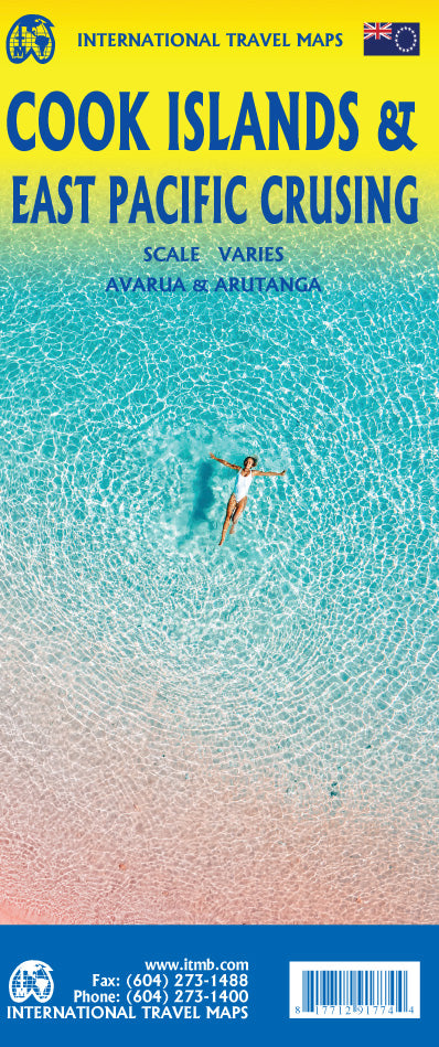
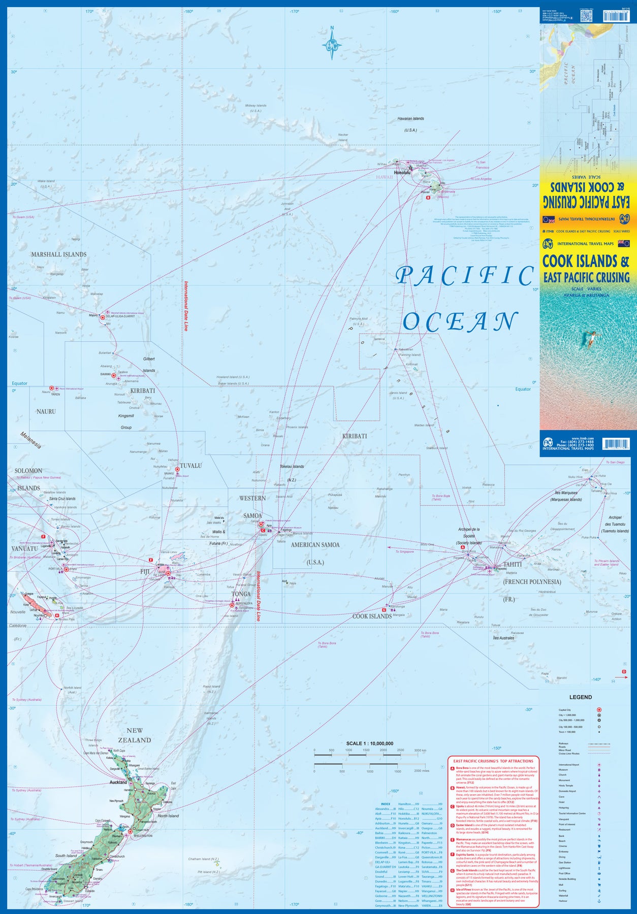
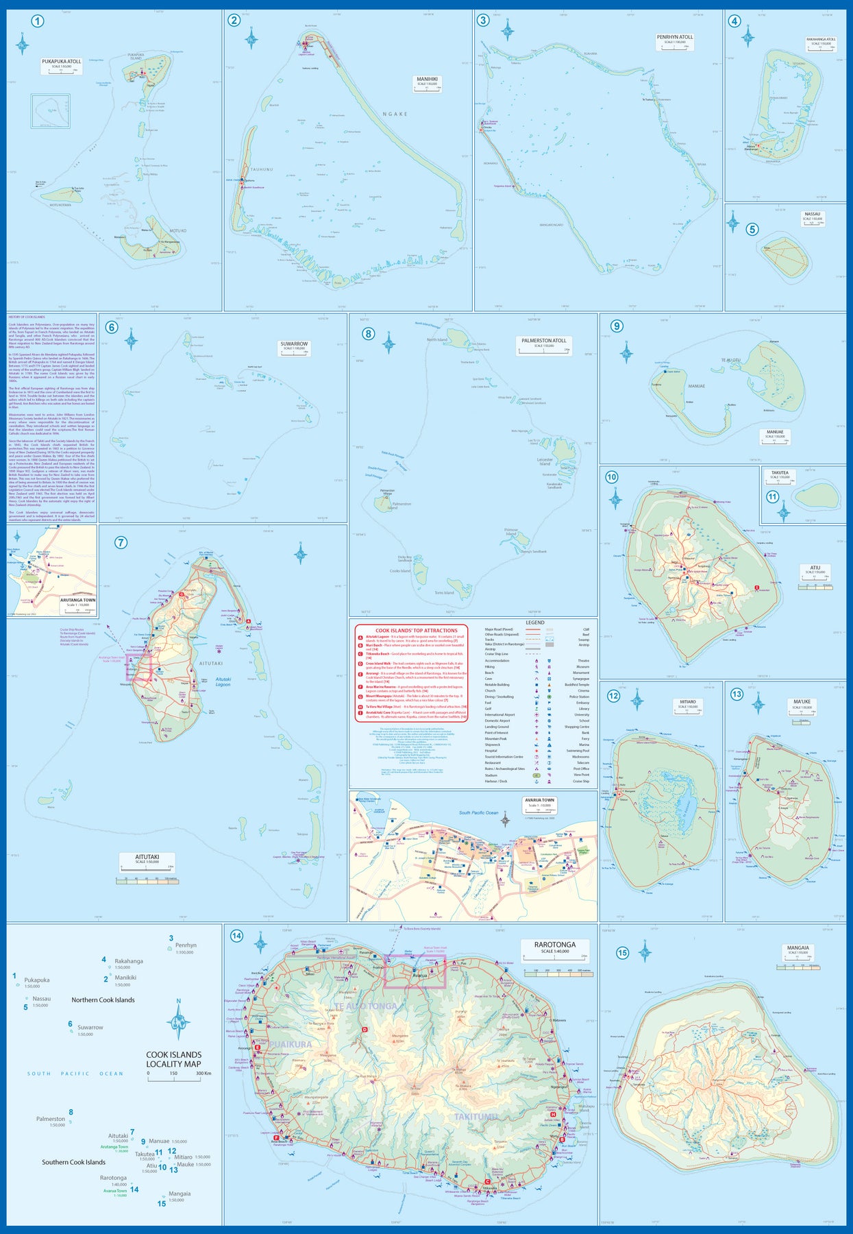
South Pacific: Cook Islands & East Pacific Cruising
Ordinær pris 199,00 kr/
Mva inkludert
Frakt beregnes i kassen.
This is a combination map, focused on two travel realities. Side 1 is a detailed map of the main islands making up the Cook Island archipelago. To provide more detail, the country is an inset map in the lower left corner, with numbers in blue, up to 15. The main map on Side 1 is a series of inset maps providing excellent detail of individual islands, such as Raratonga, Mangaia, or Aitutaki, or island groupings of more northerly groupings that are little more than atolls, such as Penrhyn or Palmerston. The capital is Avarua, and an inset map is included; also one of Arutanga on Aitutaki. The country is well-positioned for tourism, and has many resorts, particularly on Raratonga.
Side 2 is a new map for ITMB, part of our growing Cruising line. This on covers the eastern portion of the South Pacific, from the Marshall Islands, Nauru, and the Solomons on the west to Hawaii and Tahiti on the east, and as far south as New Zealand. Other island nations included on this map are Kiribati, Tuvalu, Fiji, Samoa, and New Caledonia. By the nature of portraying a vast ocean, little detail of each island can be provided. The purpose of this map is to show routes followed by ships visiting the overall region. This is a rapidly-growing travel area for major cruise lines, and promises to be as attractive in the future as cruises in the Caribbean or Mediterranean. This region holds great prospects for the future. Besides, it is a lovely map to look at.
- Publisert: 2022
- Innbinding: Falset
- Materiale: Papir
- Målestokk: Varierende

Dalmatia, Croatian Coastline - Central and South
Ordinær pris 169,00 kr/
Mva inkludert
Frakt beregnes i kassen.
Marco Polo Croatia Dalmatian Coast Map: the ideal map for your tripLet the Marco Polo Dalmatian Coast Road Map guide you around this beautiful region of Croatia. Discover one of Europe's most beautiful coastlines and explore the truly breath-taking National Parks with this highly durable, detailed, touring map of Croatia's Dalmatian Coast. It folds away easily and is always on standby to help when you're stuck.
- Publisert: 2019-2022
- Innbinding: Falset
- Materiale: Papir
- Målestokk: 1:200 000

New Zealand - South Island
Ordinær pris 199,00 kr/
Mva inkludert
Frakt beregnes i kassen.
Highly tear-resistant and 100% waterproof map "New Zealand, South Island" from the series world mapping project.
Travel know-how maps are characterized by particularly sturdy plastic paper, which can be written on like paper, even with a pencil. The cardboard envelope is removable, making it easy to put the card in any pocket. A protective cover is not required. The cartographic representation focuses on the most important information for travelers and is particularly easy to read. Instead of shading, colored layers of elevation are used.
- Contour lines with elevation information
- Colored elevation layers
- Classified road network with distance information
- Sights
- Detailed location index
- GPS-accurate
- Longitude and latitude
- Five-language legend (german, English, French, Spanish, Russian)
- Overview map of New Zealand
- Publisert: 2023
- Innbinding: Falset
- Materiale: Plastpapir
- Målestokk: 1:550 000

Kazakhstan, Kyrgyzstan, Tajikistan, Turkmenistan, Uzbekistan
Ordinær pris 99,50 kr/
Mva inkludert
Frakt beregnes i kassen.
Gizi Map er en serie presise kart med detaljer og opplysninger over både populære og mindre populære reisemål. Dekker ofte områder der få andre kartprodusenter dekker.
- Publisert: 2020
- Innbinding: Falset
- Materiale: Papir
- Målestokk: 1:3 000 000

1 Södra Götaland
Ordinær pris 199,00 kr/
Mva inkludert
Frakt beregnes i kassen.
- Publisert: -> 2025
- Innbinding: Falset
- Materiale: Papir
- Målestokk: 1:250 000

2130 Tatra
Ordinær pris 229,00 kr/
Mva inkludert
Frakt beregnes i kassen.
- Publisert: 2024
- Innbinding: Falset
- Materiale: Papir
- Målestokk: 1:25 000

Baltic States & Region Kaliningrad
Ordinær pris 199,00 kr/
Mva inkludert
Frakt beregnes i kassen.
Baltic States - Estonia, Latvia and Lithuania - at 1:600,000 on a waterproof and tear-resistant, indexed road map with topographic and tourist information. The map, published by Reise Know-How as part of their highly acclaimed World Mapping Project, is double-sided to provide the best balance between a good scale and a convenient size sheet. Coverage includes the whole of the Kaliningradskaya Oblast of Russia and the adjoining areas of Poland as far as Elk, Olsztyn and Malbork. Old German names are shown for main towns in these areas, as well as for some of the locations within Lithuania and Latvia.
Road and rail networks are easy to see on a clear base which presents topography by altitude colouring with contours, spot heights, mountain passes and names of mountain ranges, and marshes. Road network includes local roads and tracks and gives driving distances on main and secondary roads. Ferry connections are also marked. Internal administrative boundaries are shown with names of the provinces. National parks and protected areas are marked and symbols highlight various places of interest, including campsites, UNESCO world heritage sites, archaeological remains, castles and churches, museums, viewpoints, beaches, etc. The map has a grid with latitude and longitude at intervals of 30’ and an extensive index of localities which lists national parks separately. Map legend includes English.
- Publisert: 2022
- Innbinding: Falset
- Materiale: Plastpapir
- Målestokk: 1:600 000

Ethiopia, Somalia, Eritrea & Djibouti
Ordinær pris 169,00 kr/
Mva inkludert
Frakt beregnes i kassen.
Ethiopia with Eritrea, Somalia and Djibouti at 1:1,800,000 on a light, waterproof and tear-resistant, indexed road map, providing both topographic and tourist information. The map, published by Reise-Know-How as part of their highly acclaimed World Mapping Project, is double-sided, with a generous overlap between the sides, to provide the best balance between a good scale and a convenient size sheet.
Road and rail networks are easy to see on a clear base which presents topography by altitude colouring with contours, spot heights, mountain passes and names of mountain ranges. Salt pans, swamps, seasonal rivers and lakes, oases, caves, hot springs and coral reefs are indicated. Road network includes seasonal local tracks, gives driving distances on main roads, and shows locations of fuel supplies and border crossings. Local airfields are also marked. Internal administrative boundaries are shown with names of the provinces. National parks and protected areas are marked and symbols highlight various places of interest, including UNESCO world heritage sites, archaeological remains, churches and monasteries, mosques, viewpoints, beaches, etc. Campsites, particularly within Ethiopia, and locations of wells and water tanks are indicated.
The map has a grid with latitude and longitude at intervals of 1º, and a separate index of localities for each country, plus a list of national parks and reverse. Map legend includes English.
- Publisert: 2020
- Innbinding: Falset
- Materiale: Vannfast papir
- Målestokk: 1:1 800 000

Lombardy
Ordinær pris 189,00 kr/
Mva inkludert
Frakt beregnes i kassen.
Marco Polo er svært detaljerte kart som er praktiske og enkle i bruk. 7 klistremerker for å markere spesifikke steder gjør det enda enklere å planlegge reisen. Alle kartene inneholder en omfattende index for enkelt å finne frem.
- Publisert: 2023
- Innbinding: Falset
- Materiale: Papir
- Målestokk: 1:200 000

Spain: Mallorca
Ordinær pris 199,00 kr/
Mva inkludert
Frakt beregnes i kassen.
Majorca at 1:50,000 on a large, double-sided, contoured map from Freytag & Berndt, with highlighting for scenic roads and tourist routes, plus a booklet with a GPS-annotated index, street plan of central Palma, and multilingual descriptions of the island’s best sights.
- Publisert: 2022
- Innbinding: Falset
- Materiale: Papir
-
Målestokk: 1:150 000

North Macedonia
Ordinær pris 199,00 kr/
Mva inkludert
Frakt beregnes i kassen.
Dette store østerriske kartforlaget er kjent for sin klare kartografi og gode papirkvalitet. De kommer i alle målestokker, og flere av landkartene inneholder bykart og turistinformasjon.
Macedonia at 1:200,000 on a large map in Freytag & Berndt’s “Top 10 Tips” series with the index booklet also providing multilingual descriptions of the country’s 10 most interesting locations, plus a street plan of central Skopje.
Names of towns and villages are in both Latin and Cyrillic alphabets; administrative regions, geographical features and places of interest are in the Latin alphabet only.
Topography is presented by relief shading and spot heights, with names of mountain ranges, peaks, etc, plus colouring for woodlands. Road network includes local roads and selected cart tracks, indicates border crossings, and gives driving distances on most local roads. Scenic routes are highlighted. Railway lines are shown with stations. The map also shows the country’s internal administrative boundaries.
Picturesque locations and other places of interest are highlighted and the map also indicates the country’s 10 best sights which are given multilingual descriptions in the booklet. Latitude and longitude lines are drawn at 10’ intervals. The index lists locations with their postcodes. The booklet also includes a street plan of central Skopje.
Publisert: 2025
Innbinding: falset
Material: papir
Målestokk: 1:200000