Filter
- Albania
- Andorra
- Angola
- Argentina
- Aserbajdsjan
- Australia
- Bahamas
- Bahrain
- Bangladesh
- Belgia
- Belize
- Benin
- Bolivia
- Bosnia-Hercegovina
- Brasil
- Brunei
- Bulgaria
- Burundi
- Canada
- Chile
- Costa Rica
- Cuba
- Danmark
- Djibouti
- Dominica
- Ecuador
- El Salvador
- Eritrea
- Estland
- Eswatini
- Etiopia
- Fiji
- Finland
- Frankrike
- Guyana
- Hellas
- Honduras
- Hviterussland
- India
- Indonesia
- Irak
- Iran
- Irland
- Island
- Italia
- Jamaica
- Japan
- Kambodsja
- Kasakhstan
- Kenya
- Kina
- Kirgisistan
- Kongo
- Kosovo
- Kroatia
- Kuwait
- Laos
- Latvia
- Lesotho
- Libanon
- Libya
- Liechtenstein
- Litauen
- Luxembourg
- Malawi
- Malaysia
- Mali
- Malta
- Marokko
- Mauritania
- Mauritius
- Mexico
- Mongolia
- Montenegro
- Mosambik
- Nederland
- Nepal
- New Zealand
- Nicaragua
- Niger
- Nigeria
- Nord-Makedonia
- Norge
- Oman
- Pakistan
- Panama
- Paraguay
- Peru
- Polen
- Portugal
- Romania
- Russland
- Rwanda
- Samoa
- San Marino
- Serbia
- Sierra Leone
- Singapore
- Slovakia
- Slovenia
- Solomonøyene
- Somalia
- Spania
- Sri Lanka
- Storbritannia
- Surinam
- Sveits
- Sverige
- Sør-Korea
- Taiwan
- Thailand
- Togo
- Tonga
- Tsjekkia
- Tunisia
- Turkmenistan
- Tyskland
- Uganda
- Ukraina
- Ungarn
- Uruguay
- USA
- Usbekistan
- Vanuatu
- Venezuela
- Vietnam
- Østerrike
753 produkter
753 produkter


Austria
Ordinær pris 199,00 kr/
Mva inkludert
Frakt beregnes i kassen.
Dette store østerriske kartforlaget er kjent for sin klare kartografi og gode papirkvalitet. De kommer i alle målestokker, og flere av landkartene inneholder bykart og turistinformasjon.
- Publisert: 2024
- Innbinding: Falset
- Materiale: Papir
- Målestokk: 1:500 000

Austria - Burgenland
Ordinær pris 189,00 kr/
Mva inkludert
Frakt beregnes i kassen.
Dette store østerriske kartforlaget er kjent for sin klare kartografi og gode papirkvalitet. De kommer i alle målestokker, og flere av landkartene inneholder bykart og turistinformasjon.
Burgenland at 1:150,000 in a series of road maps from Freytag & Berndt, the country’s leading publishers, with a separate index attached to the cover. Information includes sightseeing routes and long-distance hiking trails.
The maps have clear, effective relief shading to show the topography and indicate steep roads with gradient marks, show traffic restrictions and seasonal closures on mountain roads, etc. Tourist information includes scenic roads and special tourist sightseeing routes, places of interest, campsites and youth hostels, etc. An overprint highlights the national network of the long-distance footpaths indicating, where appropriate, their European numbers. A grid in steps of 10' indicates latitude and longitude. *Map legend includes English.* A separate index attached to the cover gives the postcode for each locality.
Publisert år: 2024
Innbinding: falset
Material: papir
Målestokk: 1:150,000

Austria: Fischbacher Alpen
Ordinær pris 199,00 kr/
Mva inkludert
Frakt beregnes i kassen.
Freytag & Berndt hiking maps are the perfect companion for hiking, mountaineering and ski touring, thanks to detailed digital cartography and precise yardsticks. They are regularly revised and contain updated information on hiking trails, cycling and mountain biking trails, huts, natural monuments, cultural attractions and leisure facilities.
The enclosed information booklet contains a selection of the best hiking trails, cycle paths and mountain bike trails as well as a short description of the individual municipalities with their leisure time activities. (Language: German)
Leisure information, hiking and long-distance hiking trails, mountain biking and cycling tours, local register with zip codes, GPS-capable, via ferrata, ski route, cross-country route, Nordic walking trail;
- Region: Wechsel, Mürztal, Joglland, Wiener Alpenbogen; Special hiking theme trails: Gloggnitzer Rundwanderweg, Ghega-Semmeringbahn, Alpannonia, Wiener Alpenbogen, Wechselbergland Höhenweg, Gebirgsjäger Gedächtnisweg, Arzberg-Rundwanderweg;
- Special cycling and mountain bike tours: Mürztalradweg, Feistritztalradweg, Semmering-Radweg, Joglland-Radlroas, Mountainbike-Runde Langenwang - Hönigsberg - Malleisten Alm - Feistritz, Fischbacher Alpen Tour
- Publisert: 2025
- Innbinding: Falset
- Materiale: Vannfast papir
- Målestokk: 1:50 000

Austria: Vienna
Ordinær pris 199,00 kr/
Mva inkludert
Frakt beregnes i kassen.
Street plan of the whole of the administrative area of the city, showing the entire public transport system, but no one-way streets. A separate index, attached to the map cover, includes list of useful addresses, as well as an enlargement of the city centre, a map of the through roads across the city and a diagram of the public transport network. Map legend includes English.
- Publisert: 2024
- Innbinding: Falset
- Materiale: Papir
- Målestokk: 1:25 000


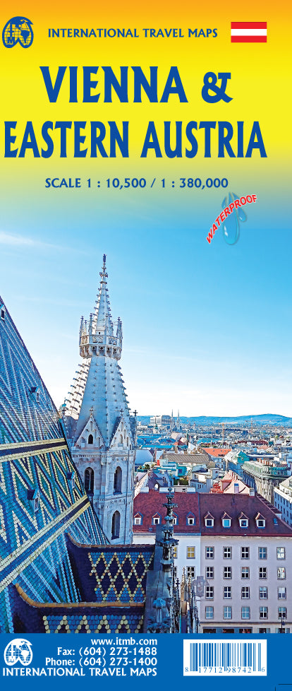
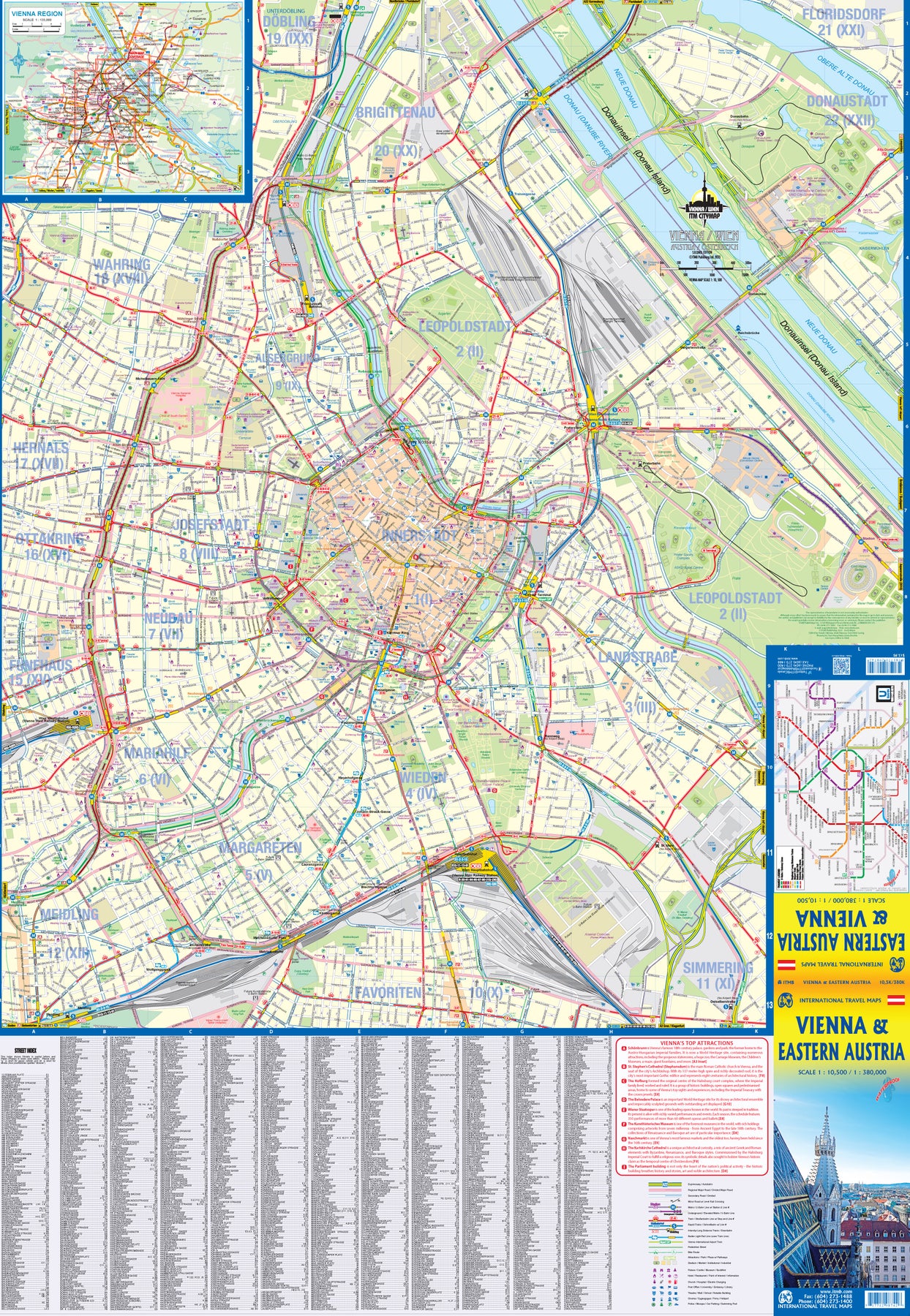
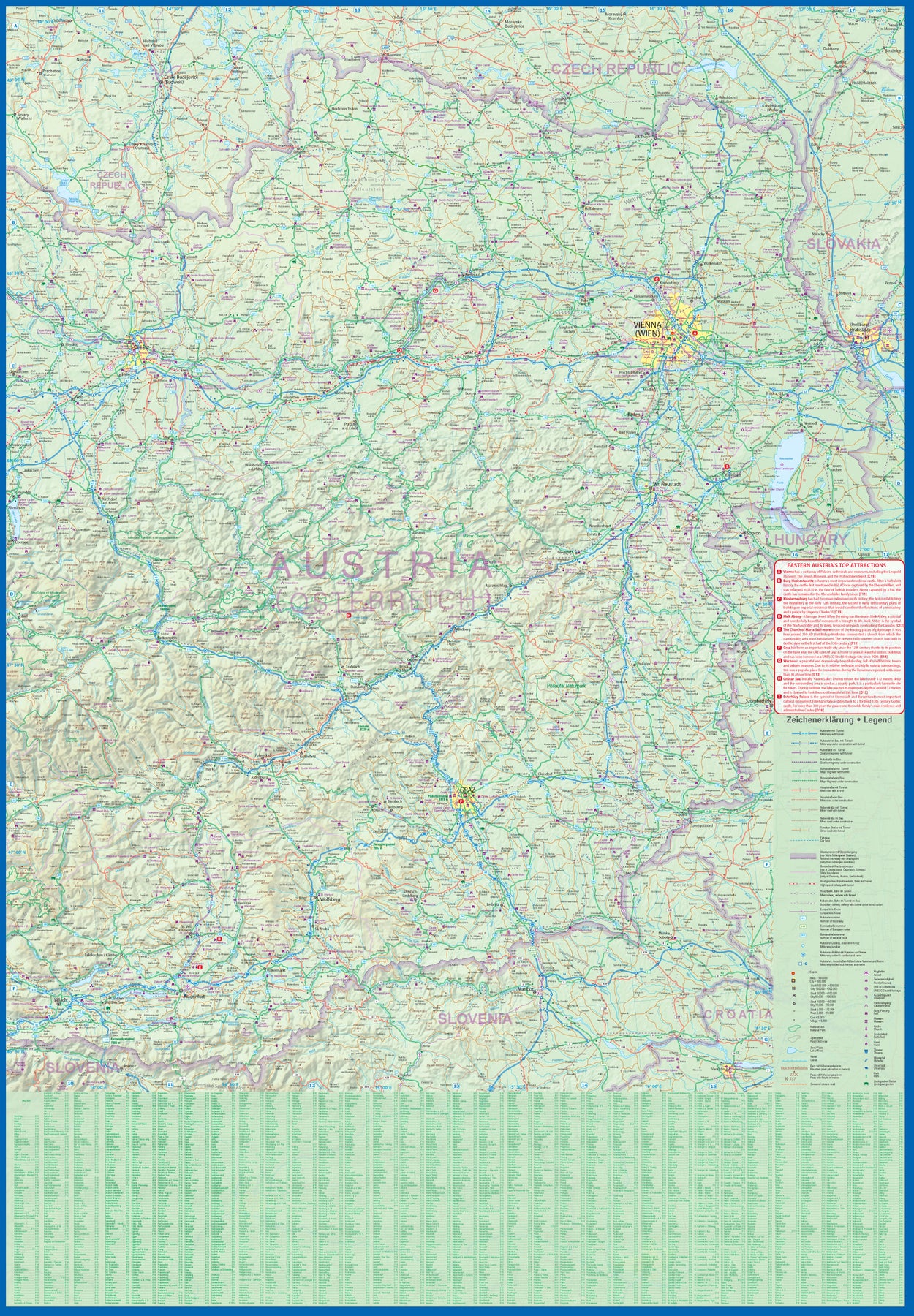
Austria: Vienna & Eastern Austria
Ordinær pris 179,00 kr/
Mva inkludert
Frakt beregnes i kassen.
ITMB is pleased to introduce an exciting new map of the wonderful city of Vienna, combined with a newly-prepared map of eastern Austria. Until WW2, Vienna was one of the most diverse and cultural cities in Europe. The NAZI takeover changed all of that and its brutal capture by the Russians five years later sent the city into a devastating downturn. Fortunately, the Soviet Union was forced to withdraw and Austria declared to be a demilitarized neutral country for the rest of the Cold War. Vienna is now a lovely historic city on the Danube River, the capital of Austria, and the European United Nations centre. The Innerstadt (Inner or old city centre) is the location of many of the hotels gracing Vienna, as well as St, Stephen’s Cathedral with its wonderful roof. One of the great attractions of the city is the Schonbrunn, the 18th Century palace of the Austro-Hungarian Empire.
The map extends from the western ring road to the UN complex east of the Danube, and from the northern edge of the urban area to south of the Hauptbahnhof (or main railway station). All Metro and tram lines are clearly shown, along with parks, churches, shopping areas, hotels, and the city’s three rail stations. The second side of the sheet is a very detailed map of the eastern half of Austria from the /Czech border on the north, the Hungarian border to the east, to the Slovenian border to the south, and west to Linz and Klagenfurt. Rail lines are prominently noted, as are motorways and all highways. Once one leaves Vienna, a vista of rural mountainous countryside unfolds, with dozens of ancient castles to explore, and interesting small towns to explore. Burg Hochosterwitz is one of Europe’s most ancient castles, dating from 860AD.
- Publisert: 2023
- Innbinding: Falset
- Materiale: VanntettPapir
- Målestokk: 1:10,500 / 1:380 000

Azerbaijan
Ordinær pris 169,00 kr/
Mva inkludert
Frakt beregnes i kassen.
Azerbaijan at 1:400,000 on a light, waterproof and tear-resistant, double-sided indexed map from Reise-Know-How. The map covers Azerbaijan and its Nakhchivan enclave; the armistice boundary of Nagorno-Karabakh is clearly marked, indicating open or closed border crossings, and where appropriate both Azeri and Armenian names of location are shown. Coverage includes eastern Armenia and south-eastern Georgia with Tbilisi.
Topography is presented by altitude colouring with spot heights and names of mountain ranges, peaks, passes, etc, plus boundaries of national parks and other protected areas. Road network includes selected unsurfaced local roads and tracks, and indicates driving distances on main routes. Railway lines are included and local airfields are marked. Internal administrative boundaries are presented with names of the provinces. Symbols highlight various places of interest, including locations with tourist accommodation, cultural heritage, beaches, etc. Also marked are oil wells and pipelines. Longitude and longitude lines are drawn at 30’ intervals. Map legend includes English.
- Publisert: 2016
- Innbinding: Falset
- Materiale: Plastpapir
- Målestokk: 1:275 000


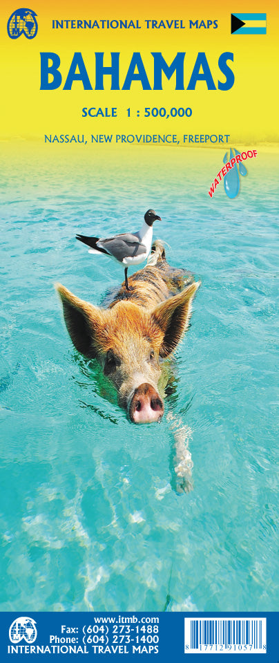
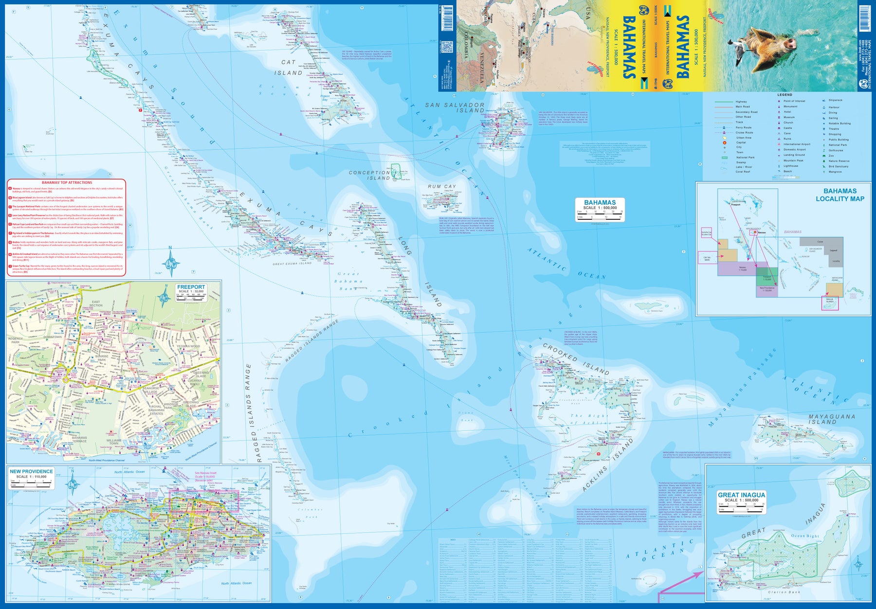
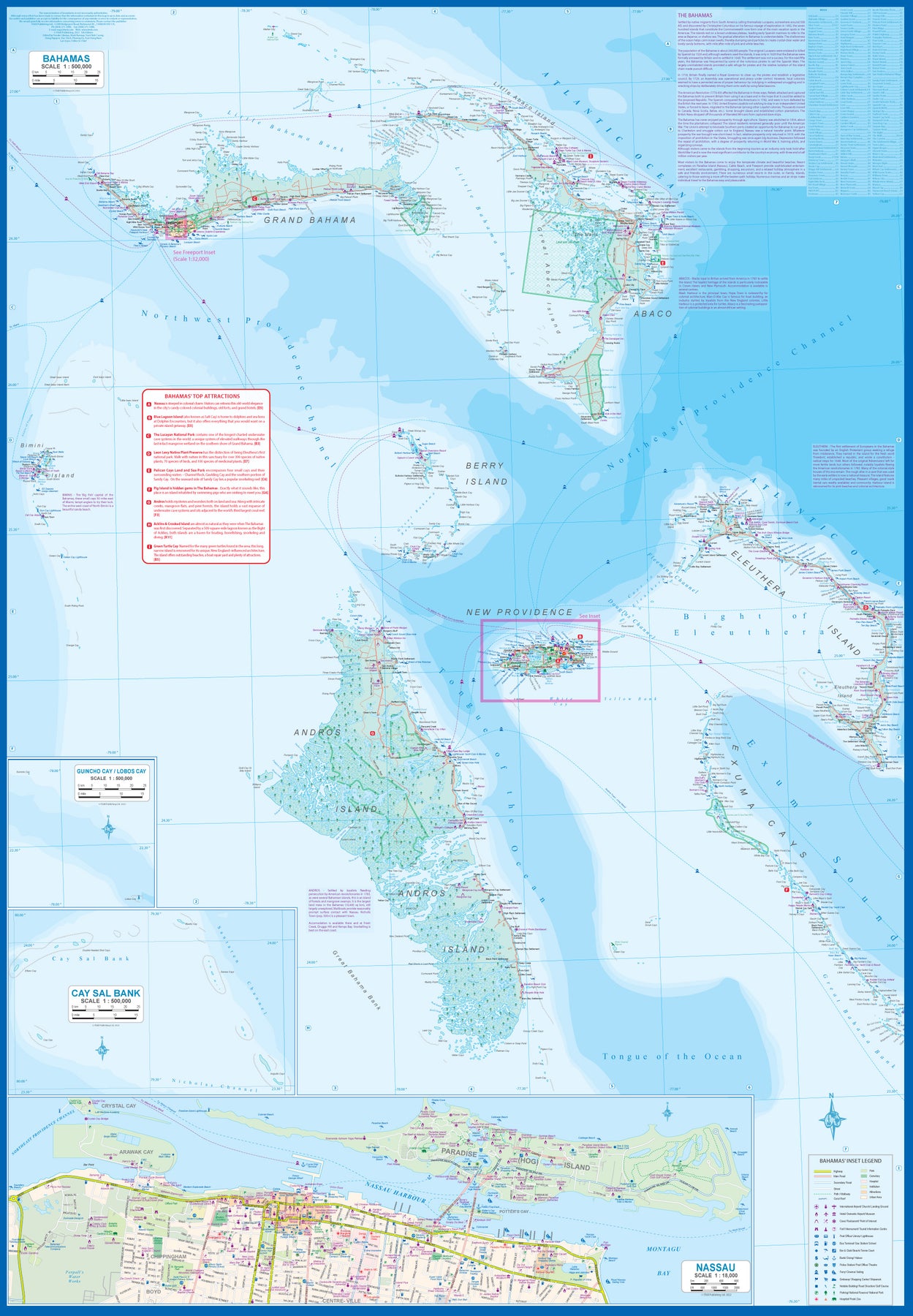
Bahamas
Ordinær pris 189,00 kr/
Mva inkludert
Frakt beregnes i kassen.
ITM har kart over hele verden og de spesialiserer seg på land litt utenfor allfarvei. Beliggenheten til landets nasjonalparker, historiske monumenter, de viktigste veiene o.L. Finner du inkludert i kartene. Samtlige landkart har ofte et bykart over hovedstaden.
Fra ITM: This fifth edition of our popular travel map to the many Bahamian islands shows a wealth of accommodations, beaches, and points of interest. Inset maps of Nasau and Freeport detail the two largest cities, and a special inset of New Providence Island, the most popular tourist destination, shows resorts and attractions that make this island so popular. As usual, we include a Top Attractions list of the 'must see' destinations.
Publisert år: 2023
Innbinding: falset
Material: plastpapir
Målestokk: 1:500,000

Balkans: Croatia; Slovenia & Bosnia Herzegovina
Ordinær pris 199,00 kr/
Mva inkludert
Frakt beregnes i kassen.
Attractive road map of the region with hill-shading to show the general relief. Road detail includes selected secondary roads, and distinguishes toll roads and scenic routes. Intermediate driving distances are indicated. Caravan restrictions are shown, also steep gradients and seasonal road closures. Other details include ferries, cable car lines, railways, border crossings, campsites, antiquities, various landmarks, viewpoints and sites of interest. National parks and provincial boundaries are marked. Latitude and longitude lines are drawn at 30' intervals. Legend includes English.
here is also an inset political map of the wider Balkan region.
- Publisert: 2024
- Innbinding: Falset
- Materiale: Papir
- Målestokk: 1:500 000

Baltic Sea
Ordinær pris 199,00 kr/
Mva inkludert
Frakt beregnes i kassen.
Highly tear-resistant and 100% waterproof map "Baltic Sea" from the series world mapping project with city maps Gdansk, Helsinki, Copenhagen, Riga, St. Petersburg, Stockholm and Tallinn.
Travel know-how maps are an indispensable tool in travel planning. They are characterized by particularly sturdy plastic paper, which can be written on like paper, even with a pencil. The cardboard envelope is removable, making it easy to put the card in any pocket. A protective cover is not required. The cartographic representation focuses on the most important information for travelers and is particularly easy to read. Instead of shading, colored layers of elevation are used.
- Contour lines and colored elevation layers
- Classified road network with distance information
- Sights
- GPS-accurate
- Longitude and latitude
- Five-language legend (german, English, French, Spanish, Russian)
- Baltic Sea map 1-page
- On the back city maps of Gdansk, Copenhagen, Stockholm, Helsinki, St. Petersburg, Tallinn and Riga as well as 24 photos around the Baltic Sea.
- Publisert: 2023
- Innbinding: Falset
- Materiale: Plastpapir
- Målestokk: 1:1 300 000

Baltic States & Region Kaliningrad
Ordinær pris 199,00 kr/
Mva inkludert
Frakt beregnes i kassen.
Baltic States - Estonia, Latvia and Lithuania - at 1:600,000 on a waterproof and tear-resistant, indexed road map with topographic and tourist information. The map, published by Reise Know-How as part of their highly acclaimed World Mapping Project, is double-sided to provide the best balance between a good scale and a convenient size sheet. Coverage includes the whole of the Kaliningradskaya Oblast of Russia and the adjoining areas of Poland as far as Elk, Olsztyn and Malbork. Old German names are shown for main towns in these areas, as well as for some of the locations within Lithuania and Latvia.
Road and rail networks are easy to see on a clear base which presents topography by altitude colouring with contours, spot heights, mountain passes and names of mountain ranges, and marshes. Road network includes local roads and tracks and gives driving distances on main and secondary roads. Ferry connections are also marked. Internal administrative boundaries are shown with names of the provinces. National parks and protected areas are marked and symbols highlight various places of interest, including campsites, UNESCO world heritage sites, archaeological remains, castles and churches, museums, viewpoints, beaches, etc. The map has a grid with latitude and longitude at intervals of 30’ and an extensive index of localities which lists national parks separately. Map legend includes English.
- Publisert: 2022
- Innbinding: Falset
- Materiale: Plastpapir
- Målestokk: 1:600 000

Lonely Planet Barcelona
Ordinær pris 119,00 kr/
Mva inkludert
Frakt beregnes i kassen.
Lonely Planet City Map er slitesterkt og vanntett, med en hendig slipcase og et format som er lett å brette. Få mer ut av kartet og reisen din med bilder og informasjon om byattraksjoner, transportkart, reiseruteforslag, omfattende gate- og nettstedsindeks og praktiske reisetips. Med dette brukervennlige navigasjonsverktøyet i baklommen kan du virkelig komme til hjertet av din destinasjon!
- Publisert: Des. 2023
- Utgave: 2.utg
- Innbinding: Falset
- Material: Plast papir
- ISBN: 9781787015296

Barcelona
Ordinær pris 159,00 kr/
Mva inkludert
Frakt beregnes i kassen.
Let the Marco Polo city map of Barcelona guide you around this awe-inspiring city. Highly durable and waterproof, this handy, pocket-size Barcelona map folds away easily and is always on standby to help when you're stuck.
- Publisert: Mars 2025
- Innbinding: Falset
- Materiale: Vannfast papir
- Målestokk: 1:12 000

Bath
Ordinær pris 99,00 kr/
Mva inkludert
Frakt beregnes i kassen.
Kart i postkortstørrelse. Folder seg ut som en popoutbok når du åpner dem. Fargerik turistinformasjon med kart over metro og busstraseer, landemerker og lignende. Veldig enkel å håndtere.
- Publisert: November 2022
- Innbinding: Popout
- Materiale: Papp, papir

Lonely Planet Beijing
Ordinær pris 119,00 kr/
Mva inkludert
Frakt beregnes i kassen.
Lonely Planet City Map er slitesterkt og vanntett, med en hendig slipcase og et format som er lett å brette. Få mer ut av kartet og reisen din med bilder og informasjon om byattraksjoner, transportkart, reiseruteforslag, omfattende gate- og nettstedsindeks og praktiske reisetips. Med dette brukervennlige navigasjonsverktøyet i baklommen kan du virkelig komme til hjertet av din destinasjon!
- Publisert: Sep, 2017
- Utgave: 1.utg
- Innbinding: Falset
- Material: Plastpapir

Belarus
Ordinær pris 149,00 kr/
Mva inkludert
Frakt beregnes i kassen.
ITM har kart over hele verden og de spesialiserer seg på land litt utenfor allfarvei. Beliggenheten til landets nasjonalparker, historiske monumenter, de viktigste veiene o.L. Finner du inkludert i kartene. Samtlige landkart har ofte et bykart over hovedstaden.
Fra ITM: 2nd edition October 2015. Folded map with detailed road and rail network, National Parks and Reserves with complete index of all cities and towns in the map. In this edition, major urban areas are shown in Cyrillic as well as the Latin alphabet, hypsometry has been re-worked to show elevation differences better. This is a double-sided map of the country (divided into west and east halves) with part of Lithuania on the western part and a fair amount of Russia on the eastern side. Known international border crossings are shown, except on crossing into Russia, which are numerous. A large inset map for Minsk in a very suitable scale (1:15.000 Scale) comprising most of the touristic sights and places of interest and Metro lines has also been provided that is far better than what we could show previously.
Publisert år: 2015
Innbinding: falset
Material: papir
Målestokk: 1:600000

Belarus
Ordinær pris 169,00 kr/
Mva inkludert
Frakt beregnes i kassen.
Tysk kartserie med flotte kart på slitesterkt plastpapir.
Reise Know-How maps (world mapping project series) are easy-to-read, waterproof and highly durable travel maps specifically designed for everyday use on the road.
The maps combine state-of-the-art, GPS-compatible cartography (including hypsometric tints and contour lines) with a detailed rendering of road networks and touristic information. They offer the best possible scale, level of detail and readability, be it a map of a small island or half a continent.
The maps feature a detachable paper sleeve so that the maps can be folded easily and fit in every pocket. Although printed on plastic, a special coating makes sure the maps retain a paper-like feel and can even be written on with a pencil.
Publisert år: 2018
Innbinding: falset
Material: Plastpapir
Målestokk: 1:550,000

Belgium & Luxembourg
Ordinær pris 189,00 kr/
Mva inkludert
Frakt beregnes i kassen.
Let the Marco Polo Belgium and Luxembourg Road Map guide you around these beautiful countries. Discover picturesque towns, distinctive castles, Flanders Fields and the smallest city in the world with this highly durable, detailed touring map of Belgium and Luxembourg. It folds away easily and is always on standby to help when you're stuck.
- Publisert: 2024
- Innbinding: Falset
- Materiale: Papir
- Målestokk: 1:250 000

Belize
Ordinær pris 149,00 kr/
Mva inkludert
Frakt beregnes i kassen.
- Publisert: 2022
- Innbinding: Falset
- Materiale: Plastlaminert
- Målestokk: 1:500 000

Lonely Planet Berlin
Ordinær pris 119,00 kr/
Mva inkludert
Frakt beregnes i kassen.
Lonely Planet City Map er slitesterkt og vanntett, med en hendig slipcase og et format som er lett å brette. Få mer ut av kartet og reisen din med bilder og informasjon om byattraksjoner, transportkart, reiseruteforslag, omfattende gate- og nettstedsindeks og praktiske reisetips. Med dette brukervennlige navigasjonsverktøyet i baklommen kan du virkelig komme til hjertet av din destinasjon!
- Publisert: Des. 2023
- Utgave: 2.utg
- Innbinding: Falset
- Material: Vanntett papir
- ISBN: 9781787015319


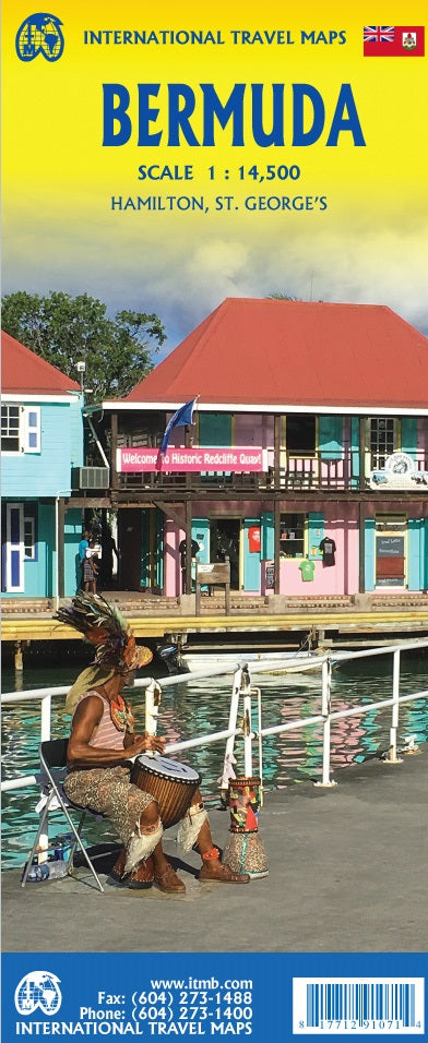
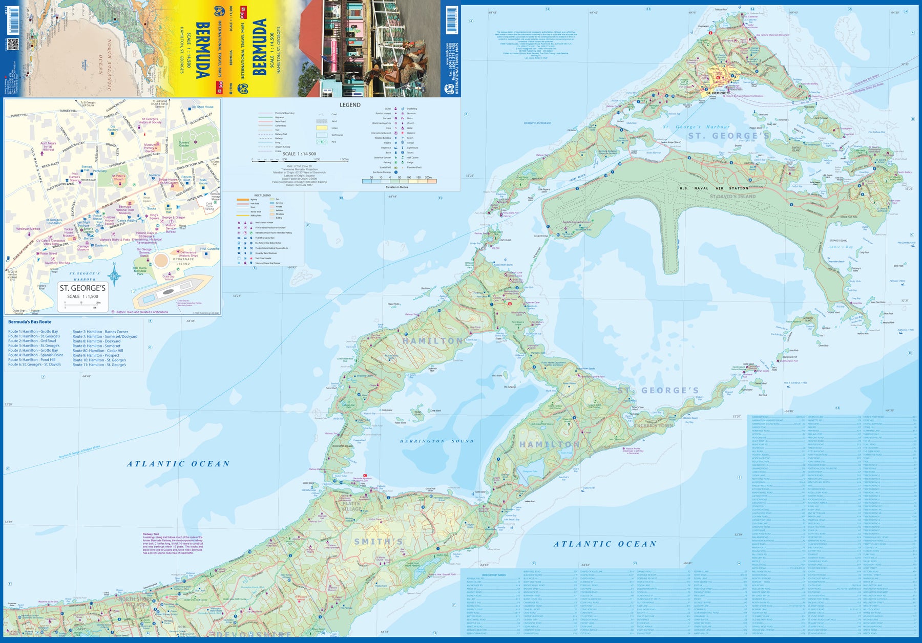
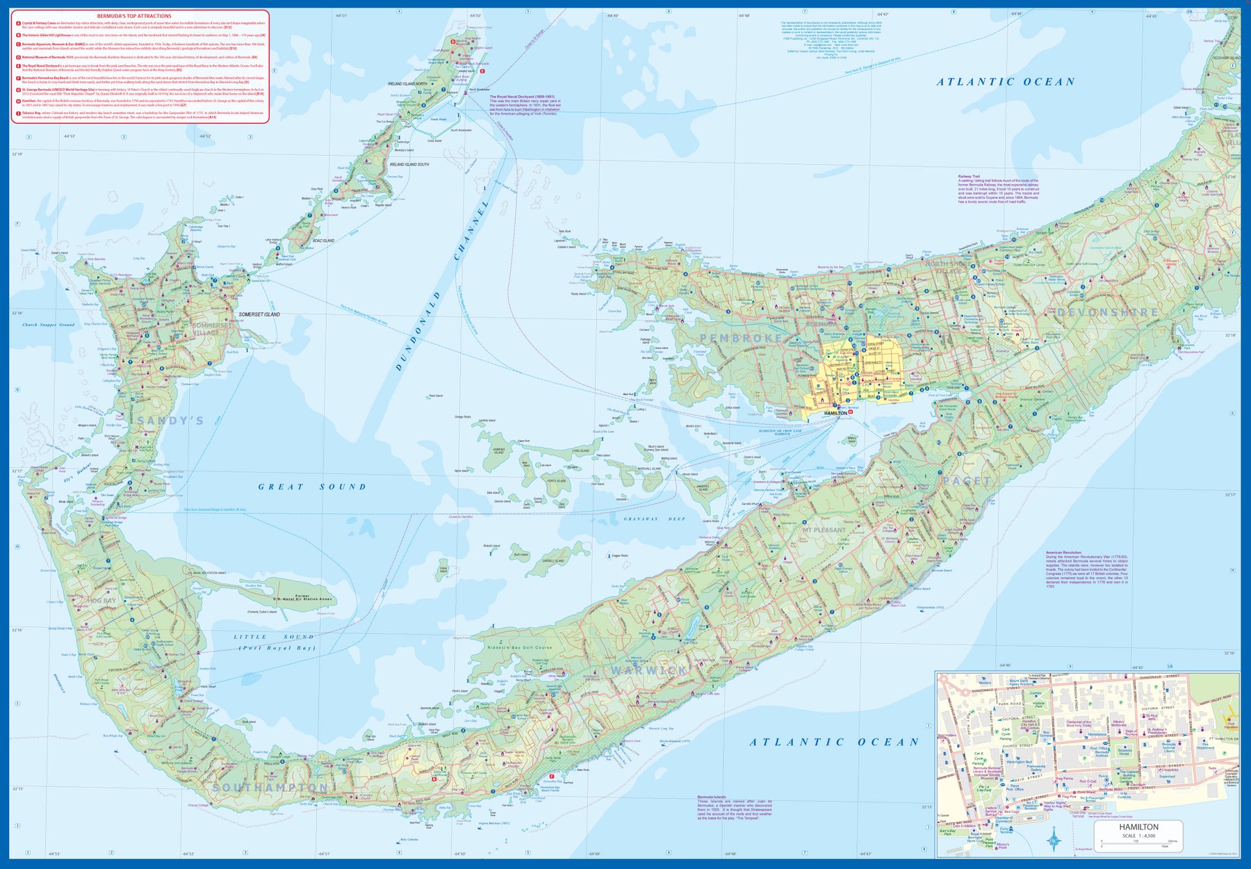
Bermuda
Ordinær pris 179,00 kr/
Mva inkludert
Frakt beregnes i kassen.
Bermuda is a lovely mid-Atlantic island far off the coast of South Carolina. It is full of colonial architecture and an ‘island’ way of life. Tourism is a key ingredient of the colony’s lifeblood and the island is very popular with cruise ships. There is ample accommodation for longer-term visitors, good roads, and much history. The airport was built by the US Navy during WW2 and is still a US Naval Air Station, but shares the runway with civil aviation.
The map includes an excellent inset of St. George’s, which still has its stocks close to the town hall, and another of Hamilton, the capital. This is where most cruise ships dock. For those with the time, the map shows the Railway Trail along the former route of the island’s now-defunct rail line. Lots to see; lots to do!
- Publisert: 2023
- Innbinding: Falset
- Materiale: Papir
- Målestokk: 1:14 500

Bhutan
Ordinær pris 349,00 kr Salgspris 174,50 kr Spar 50%/
Mva inkludert
Frakt beregnes i kassen.
Trekking Map - Great Himalaya Trail - National Parks. GPS Compatible - Comprehensive Touring & Planning Map
- Publisert: 2024
- Innbinding: Falset
- Materiale: Papir
- Målestokk: 1:400 000

Bolivia
Ordinær pris 199,00 kr/
Mva inkludert
Frakt beregnes i kassen.
ITM har kart over hele verden og de spesialiserer seg på land litt utenfor allfarvei. Beliggenheten til landets nasjonalparker, historiske monumenter, de viktigste veiene o.L. Finner du inkludert i kartene. Samtlige landkart har ofte et bykart over hovedstaden.
Fra ITM: 6th edition 2025. As a travel destination, Bolivia definitely ranks among the routes less travelled! However, it is a fascinating country and well-worth visiting. We have printed this edition on plasticized paper for durability, as one will definitely need a map to get around this mountainous country. The map shows the road network to best advantage, with distances between communities whenever possible Touristic sites are noted, and elevations, parks, and reserves. Inset maps of La Paz, Potosi, and Santa Cruz de la Sierra are included.
Publisert år: 2025
Innbinding: falset
Material: plastpapir
Målestokk: 1:1,400,000

Bordeaux
Ordinær pris 199,00 kr/
Mva inkludert
Frakt beregnes i kassen.
- Publisert: 2024
- Innbinding: Falset
- Materiale: Plastlaminert
- Målestokk: 1:15 000

Borneo
Ordinær pris 169,00 kr/
Mva inkludert
Frakt beregnes i kassen.
Our maps combine state-of-the-art, GPS-compatible cartography (including hypsometric tints and contour lines) with a detailed rendering of road networks and touristic information. They offer the best possible scale, level of detail and readability, be it a map of a small island or half a continent.
The maps feature a detachable paper sleeve so that the maps can be folded easily and fit in every pocket. Although printed on plastic, a special coating makes sure the maps retain a paper-like feel and can even be written on with a pencil.
- Publisert: 2020
- Innbinding: Falset
- Materiale: Plastpapir
- Målestokk: 1:1 200 000


Borneo & Kalimantan
Ordinær pris 199,00 kr/
Mva inkludert
Frakt beregnes i kassen.
Road map with many places and roads, railways and rivers, heights, latitude and longitude. With city maps of Kuching, Kota Kinabalu and Bandar Seri Begawan. The Island of Borneo is shared by three countries: Malaysia and Brunei have the northern portion, with the balance forming Kalimantan Province of Indonesia.
This double-sided map shows both northern and southern portions to good advantage; printed on paper. Legend Includes: International and state boundaries, roads by classifications, distances between points, rivers, lakes, national parks, beaches, hotels, lighthouses, airports, place of interests and other information.
- Publisert: 2024
- Innbinding: Falset
- Materiale: Papir
- Målestokk: 1:1 100,000, 1:1 400 000

Borneo: Sarawak; Sabah & Brunei
Ordinær pris 149,00 kr/
Mva inkludert
Frakt beregnes i kassen.
ITM har kart over hele verden og de spesialiserer seg på land litt utenfor allfarvei. Beliggenheten til landets nasjonalparker, historiske monumenter, de viktigste veiene o.L. Finner du inkludert i kartene. Samtlige landkart har ofte et bykart over hovedstaden.
Publisert år: 2012
Innbinding: falset
Material: papir
Målestokk: 1:620000

Bosnia-Herzegovina & Montenegro
Ordinær pris 169,00 kr/
Mva inkludert
Frakt beregnes i kassen.
Bosnia-Herzegovina and Montenegro at 1:350,000 on a light, waterproof and tear-resistant, double-sided indexed map published by Reise-Know-How as part of their highly acclaimed World Mapping Project. Altitude colouring with names of numerous mountain ranges, peaks, etc, provides a very good picture of the region’s topography. The whole of Montenegro is shown on one side, and coverage includes Croatian coast south of Sibenik. Within Bosnia, internal administrative boundaries show Republica Srpska where names of main towns are also given in the Cyrillic alphabet.
Road network indicates gravel roads and includes selected local tracks and paths. Scenic routes are highlighted and driving distances marked on main routes. Railway lines are included, local airfields are marked, and along the Croatian coast ferry routes are shown. Internal administrative boundaries are presented with names of the provinces. Symbols highlight various places of interest and facilities, including campsites and mountain refuges, cultural and historical heritage, beaches, etc. Longitude and longitude lines are drawn at 20’ intervals. Map legend includes English.
- Publisert: 2025
- Innbinding: Falset
- Materiale: Plastpapir
- Målestokk: 1:350 000

Lonely Planet Boston
Ordinær pris 119,00 kr/
Mva inkludert
Frakt beregnes i kassen.
Lonely Planet City Map er slitesterkt og vanntett, med en hendig slipcase og et format som er lett å brette. Få mer ut av kartet og reisen din med bilder og informasjon om byattraksjoner, transportkart, reiseruteforslag, omfattende gate- og nettstedsindeks og praktiske reisetips. Med dette brukervennlige navigasjonsverktøyet i baklommen kan du virkelig komme til hjertet av din destinasjon!
- Publisert: Januar 2025
- Utgave: 2. utgave
- Innbinding: Falset
- Materiale: Vannfast papir