Filter
- Albania
- Andorra
- Angola
- Argentina
- Armenia
- Aserbajdsjan
- Australia
- Bahrain
- Bangladesh
- Belgia
- Belize
- Benin
- Bhutan
- Bolivia
- Bosnia-Hercegovina
- Botswana
- Brasil
- Brunei
- Bulgaria
- Burundi
- Canada
- Chile
- Colombia
- Costa Rica
- Cuba
- Danmark
- Djibouti
- Dominica
- Ecuador
- Ekvatorial-Guinea
- El Salvador
- Eritrea
- Estland
- Eswatini
- Etiopia
- Finland
- Frankrike
- Gabon
- Gambia
- Georgia
- Guyana
- Hellas
- Honduras
- Hviterussland
- India
- Indonesia
- Irak
- Iran
- Irland
- Island
- Italia
- Jamaica
- Japan
- Kambodsja
- Kamerun
- Kasakhstan
- Kenya
- Kina
- Kirgisistan
- Kongo
- Kosovo
- Kroatia
- Kuwait
- Kypros
- Laos
- Latvia
- Lesotho
- Libanon
- Libya
- Litauen
- Luxembourg
- Malawi
- Malaysia
- Maldivene
- Mali
- Marokko
- Mauritania
- Mauritius
- Mexico
- Moldova
- Monaco
- Mongolia
- Montenegro
- Mosambik
- Namibia
- Nederland
- Nepal
- New Zealand
- Nicaragua
- Niger
- Nigeria
- Nord-Makedonia
- Norge
- Oman
- Pakistan
- Panama
- Papua Ny-Guinea
- Paraguay
- Peru
- Polen
- Portugal
- Romania
- Russland
- Rwanda
- Samoa
- Senegal
- Serbia
- Sierra Leone
- Singapore
- Slovakia
- Slovenia
- Somalia
- Spania
- Sri Lanka
- Storbritannia
- Surinam
- Sveits
- Sverige
- Sør-Afrika
- Sør-Korea
- Taiwan
- Thailand
- Togo
- Tsjekkia
- Tunisia
- Turkmenistan
- Tyrkia
- Tyskland
- Uganda
- Ungarn
- USA
- Usbekistan
- Venezuela
- Vietnam
- Østerrike
895 produkter
895 produkter
Utsolgt
Kenya
ITM
199,00 kr

Kenya
Ordinær pris 199,00 kr/
Mva inkludert
Frakt beregnes i kassen.
Reise Know-How maps (world mapping project series) are easy-to-read, waterproof and highly durable travel maps specifically designed for everyday use on the road. The maps combine state-of-the-art, GPS-compatible cartography (including hypsometric tints and contour lines) with a detailed rendering of road networks and touristic information. They offer the best possible scale, level of detail and readability, be it a map of a small island or half a continent.
The maps feature a detachable paper sleeve so that the maps can be folded easily and fit in every pocket. Although printed on plastic, a special coating makes sure the maps retain a paper-like feel and can even be written on with a pencil.
- Publisert: 2020
- Innbinding: Falset
- Materiale: Plastpapir
- Målestokk: 1:950 000

Korea: North & South
Ordinær pris 239,00 kr/
Mva inkludert
Frakt beregnes i kassen.
Reise Know-How maps (world mapping project series) are easy-to-read, waterproof and highly durable travel maps specifically designed for everyday use on the road.
Our maps combine state-of-the-art, GPS-compatible cartography (including hypsometric tints and contour lines) with a detailed rendering of road networks and touristic information. They offer the best possible scale, level of detail and readability, be it a map of a small island or half a continent.
The maps feature a detachable paper sleeve so that the maps can be folded easily and fit in every pocket. Although printed on plastic, a special coating makes sure the maps retain a paper-like feel and can even be written on with a pencil.
- Publisert: 2023
- Innbinding: Falset
- Materiale: Plastpapir
- Målestokk: 1:700 000

Kyoto
Ordinær pris 119,00 kr/
Mva inkludert
Frakt beregnes i kassen.
Lonely Planet City Map er slitesterkt og vanntett, med en hendig slipcase og et format som er lett å brette. Få mer ut av kartet og reisen din med bilder og informasjon om byattraksjoner, transportkart, reiseruteforslag, omfattende gate- og nettstedsindeks og praktiske reisetips. Med dette brukervennlige navigasjonsverktøyet i baklommen kan du virkelig komme til hjertet av din destinasjon!
- Publisert: November 2024
- Utgave: 2. utgave
- Innbinding: Falset
- Materiale: Vannfast papir
- ISBN: 9781787017047

Slovak republic
Ordinær pris 169,00 kr/
Mva inkludert
Frakt beregnes i kassen.
Marco polo er svært detajerte kart som er praktiske og enkle i bruk. 7 klistremerker for å markere spesifikke steder gjør det enda enklere å planlegge reisen. Alle kartene inneholder en omfattende index for enkelt å finne frem.
Let the Marco Polo Slovak Republic Road Map guide you around this stunning country. Discover picturesque towns, glorious mountains and distinctive castles with this highly durable, detailed touring map of Slovakia. It folds away easily and is always on standby to help when you're stuck.
Perfect touring map - the scale is 1 : 300 000 ideal to help you tour the country by car or campervanEasy to use - the superbly clear mapping in strong colours and easy to read text will help you navigate the country like a localDurable, tear-resistant map - designed to withstand the rigors of the road, the map is printed on tear-resistant, water repellent and writeable paperHighlights included - major sights and key points of interest are marked on the map by numbered stars. Further information about these key sights can be downloaded via a QR code where you'll find a brief description to help you pick the best places to see en-routeDream routes - inspirational routes with beautiful scenery are included on the maps to guide you on your next adventureExtensive index - the thorough index, also included on the QR code, is fully cross-referenced to the map to help you pinpoint your destination quicklyFor the big trips and the little detours, trust Marco Polo's clear mapping and thorough index to guide you around Slovak Republic.Publisert år: 2017
Innbinding: falset
Material: papir
Målestokk: 1:300000
Utgitt: 2023

South America
Ordinær pris 119,00 kr/
Mva inkludert
Frakt beregnes i kassen.
Lonely Planet Planning Map er slitesterkt og vanntett, med en hendig slipcase og et format som er enkelt å brette. Få mer ut av kartet og reisen din med bilder og informasjon om toppattraksjoner i landet, reiseruteforslag, en transportguide, planleggingsinformasjon, temalister og praktiske reisetips. Med dette brukervennlige navigasjonsverktøyet i baklommen kan du virkelig komme til hjertet av din destinasjon!
- Publisert: November 2019
- Utgave: 1. utgave
- Innbinding: Falset
- Materiale: Plastpapir


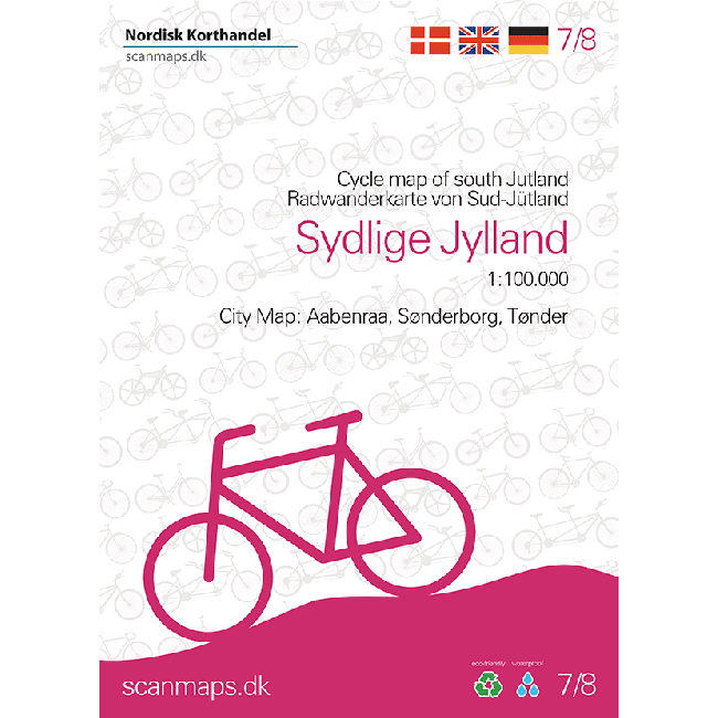
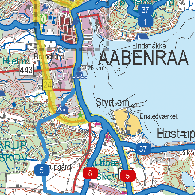
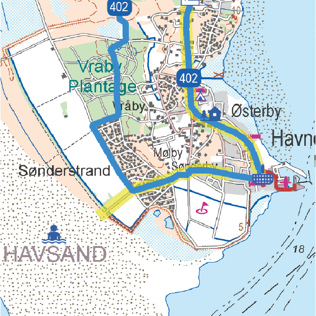
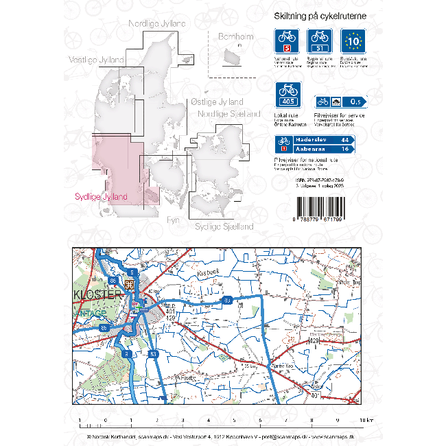
Sykkelkart 7 - Sydlige Jylland
Ordinær pris 249,00 kr/
Mva inkludert
Frakt beregnes i kassen.
- Publisert: 2023
- Innbinding: Falset
- Materiale: Plastpapir
- Målestokk: 1:100 000

Tajikistan
Ordinær pris 249,00 kr/
Mva inkludert
Frakt beregnes i kassen.
Tajikistan at 1:650,000 with excellent presentation of the country’s mountainous terrain through bold altitude colouring and plenty of names of natural features, the old Silk Routes network highlighted, plus a street plan of Dushanbe. All place names are in the Latin alphabet.
Topography with spot heights and graphics for swamps, salt flats and deserts etc. National parks are highlighted and the map shows internal administrative boundaries. Road network includes selected local tracks, Railway lines are included and local airports are marked. A variety of symbols indicate places of interest. Latitude and longitude lines are drawn at 20’ intervals.
- Publisert: 2024
- Innbinding: Falset
- Materiale: Papir
- Målestokk: 1:650 000

Thailand; Vietnam - Myanmar; Laos; Cambodia
Ordinær pris 189,00 kr/
Mva inkludert
Frakt beregnes i kassen.
The countries of South-East Asia: Thailand, Vietnam, Cambodia, Laos, Myanmar/Burma, Peninsular Malaysia and Singapore on a map at 1:2,500,000 from Marco Polo Publishing with an index which includes geographical features, three city maps, descriptions of 15 best sights, etc. Coverage extends west to Dhaka to include eastern Bangladesh and the north-eastern states of India.
Cartography is from the renowned German publishers MairDumont. Relief shading with names of mountain ranges and spot heights, plus graphics for marshlands shows the topography. The map presents the regions' road and rail networks, also indicating local airports and ferry connections. Internal administrative boundaries are shown with names of the provinces and the map also indicates time zone boundaries. Interesting towns or villages and main cultural sights or natural curiosities are prominently highlighted, with 15 best sights cross-referenced to their descriptions in the booklet attached to the map cover. The map has latitude and longitude lines at intervals of 1°. Multilingual map legend and the descriptions include English.
Extensive index is in a separate 47-page booklet attached to the map cover and includes major sights and topographic features such as rivers, lakes, volcanoes, glaciers, etc; also provided are lists of national parks and World Heritage sites across the whole are of the map. Street plans show central Bangkok, Phnom Penh and Singapore.
- Publisert: 2023
- Innbinding: Falset
- Materiale: Papir
- Målestokk: 1:2 500 000


The World
Ordinær pris 199,00 kr/
Mva inkludert
Frakt beregnes i kassen.
ITM har kart over hele verden og de spesialiserer seg på land litt utenfor allfarvei. Beliggenheten til landets nasjonalparker, historiske monumenter, de viktigste veiene o.L. Finner du inkludert i kartene. Samtlige landkart har ofte et bykart over hovedstaden.
Fra ITM: As a worldwide mapping firm, ITMB has, of course, published wall maps of the world, but until now, we have not been able to offer a convenient folded version of the world. This map portrays the world politically, with large countries showing provincial/state boundaries, as well as a good selection of cities. A map of the world involves a certain amount of political juggling in order to be acceptably accurate while noting areas of political sensitivity Thus, Ukraine is shown with its traditionally accepted borders, despite Russia’s incursions, Gaza is far too small to show, but we do name Palestine. Taiwan is in a different colour than mainland China, Western Sahara is noted by colour but not named as it doesn’t exist except in the fevered imaginations of certain countries, and the Gulf of Mexico has its normally-accepted name. Antarctica, unfortunately, does not show well. Basic time zone clocks are noted at various parts of the margin, and Spitsbergen is noted by its Norwegian name of Svalbard. Apologies for any inadvertent errors, but it is extremely difficult to prepare a map of the entire world that doesn’t offend somebody. Suggested improvements are welcomed.
Side 2 is very interesting, in that it shows the flags of all accepted countries in the world, alphabetically arranged, with the location of each entity noted as to where it is on the map side, along with basic information as to area, capital city, and population. This last aspect is as good as census information can provide. India remains the most populous nation on earth, with China a close second and the USA a distant third. Canada, as usual, is the largest country in the free world, with a population density that is one of the lowest in the world.
Publisert: 2025
Innbinding: falset
Material: papir
Målestokk: 1:1390000

Tokyo
Ordinær pris 119,00 kr/
Mva inkludert
Frakt beregnes i kassen.
Lonely Planet City Map er slitesterkt og vanntett, med en hendig slipcase og et format som er lett å brette. Få mer ut av kartet og reisen din med bilder og informasjon om byattraksjoner, transportkart, reiseruteforslag, omfattende gate- og nettstedsindeks og praktiske reisetips. Med dette brukervennlige navigasjonsverktøyet i baklommen kan du virkelig komme til hjertet av din destinasjon!
- Publisert: Desember 2023
- Utgave: 2. utgave
- Innbinding: Falset
- Materiale: Vannfast papir
- ISBN: 9781787017849

Uganda
Ordinær pris 219,00 kr/
Mva inkludert
Frakt beregnes i kassen.
Indexed, waterproof and tear-resistant road map of Uganda with topographic and tourist information, published by Reise Know-How as part of their highly acclaimed World Mapping Project. The map is double-sided to provide the best balance between a good scale and a convenient size sheet.
The country’s topography is presented by altitude colouring with contours, spot heights, mountain passes, and names of mountain and hill ranges or plateaux. Swamps and seasonal rivers are also marked. Internal administrative boundaries are shown with names of regions and provinces. Road network includes unsurfaced local roads or tracks and shows driving distances on most roads, locations of petrol stations and border crossings. Railways, local airfields and ferry routes on Lake Victoria and Lake Albert are also shown.
National parks and protected zones are clearly marked. Symbols highlight numerous places of interest, including UNESCO world heritage and archaeological sites, hotels and lodges, camping sites, hot springs, rock paintings, viewpoints, etc. The map has a latitude and longitude grid at intervals of 30’ and index of localities. Map legend includes English.
- Publisert: 2023
- Innbinding: Falset
- Materiale: Plastpapir
- Målestokk: 1:600 000

United Arab Emirates
Ordinær pris 199,00 kr/
Mva inkludert
Frakt beregnes i kassen.
Tysk kartserie med flotte kart på slitesterkt plastpapir.
United Arab Emirates at 1:600,000 on a double-sided, waterproof and tear-resistant road map with topographic and tourist information, plus a plan of Dubai City with an enlargement of its central area and a plan central Abu Dhabi City. The map is part of Reise Know-How’s highly acclaimed World Mapping Project.
Publisert år: 2025
Innbinding: falset
Material: plastpapir
Målestokk: 1:600,000

Bangkok
Ordinær pris 119,00 kr/
Mva inkludert
Frakt beregnes i kassen.
- Publisert: Juli 2024
- Utgave: 2. utgave
- Innbinding: Falset
- Materiale: Vannfast papir
- ISBN: 9781788688468

Cambodia
Ordinær pris 239,00 kr/
Mva inkludert
Frakt beregnes i kassen.
Highly tear-resistant and 100% waterproof map "Cambodia" from the world mapping project series.
Reise Know-How Maps are characterized by particularly stable plastic paper, which can be written on like paper, even with a pencil. The cardboard envelope is removable, making it easy to put the card in any pocket. A protective cover is not required. The cartographic representation focuses on the most important information for travelers and is particularly easy to read. Instead of shading, coloured height layers are used.
- Contour lines with elevations
- Coloured elevation layers
- Classified road network with distances
- Sights
- Detailed place index
- GPS-accurate
- Longitude and latitude
- Five-language legend (German, English, French, Spanish, Russian)
- Phnom Penh City Map, Plans of Angkor and Siem Reap
- Publisert: 2024
- Innbinding: Falset
- Materiale: Vannfast papir
- Målestokk: 1:500 000

Mozambique & Malawi
Ordinær pris 239,00 kr/
Mva inkludert
Frakt beregnes i kassen.
Highly tear-resistant and 100% waterproof map "Mozambique, Malawi" from the series world mapping project.
Travel know-how maps are characterized by particularly sturdy plastic paper, which can be written on like paper, even with a pencil. The cardboard envelope is removable, making it easy to put the card in any pocket. A protective cover is not required. The cartographic representation focuses on the most important information for travelers and is particularly easy to read. Instead of shading, colored layers of elevation are used.
- Contour lines with elevation information
- Colored elevation layers
- Classified road network with distance information
- Sights
- Detailed location index
- GPS-accurate
- Longitude and latitude
- Five-language legend (German, English, French, Spanish, Russian)
- With maps of Maputo and Lilongwe
- Brick South Mozambique
- Overview map on the cover
- Publisert: 2023
- Innbinding: Falset
- Materiale: Plastpapir
- Målestokk: 1:1 200 000

Namibia
Ordinær pris 199,00 kr/
Mva inkludert
Frakt beregnes i kassen.
Namibia at 1:1,000,000 from Freytag & Berndt with a separate booklet attached to the map cover also providing a street plan of central Windhoek. The map is double-sided with a very generous overlap between the sides. Caprivi Strip is shown as a separate inset at 1:1,200,000
Topography is shown by relief shading with spot heights plus graphics and/or colouring indicating sandy or rocky deserts, salt lakes or flats, wells and hot springs, etc. Many seasonal rivers and lakes are included. National parks and other protected areas are prominently highlighted.
Road network includes country tracks, with road numbers very clearly presented and distances shown on many smaller routes. Locations of petrol stations and border crossings are marked. Railway lines are included and local airports are marked. Also shown are internal administrative boundaries with names of the provinces.
Symbols highlight various places of interest including UNESCO World Heritage sites. The map has latitude and longitude lines at 1° intervals. Most place names are in larger print than found on other maps. Multilingual map legend includes English.
- Publisert: 2023-2025
- Innbinding: Falset
- Materiale: Papir
- Målestokk: 1:1 000 000

Namibia
Ordinær pris 239,00 kr/
Mva inkludert
Frakt beregnes i kassen.
Namibia at 1:1,200,000 on an indexed, waterproof and tear-resistant road map with topographic and tourist information, published by Reise Know-How as part of their highly acclaimed World Mapping Project. The map is double-sided to provide the best balance between a good scale and a convenient size sheet; the country is divided north/south with a very generous overlap and Windhoek included on both sides. The eastern Kavango and Zambezi provinces (previously the Caprivi Strip) are shown on an inset.
The country’s topography is presented by altitude colouring with contours, spot heights, mountain passes, and names of mountain ranges. The map also shows salt lakes and seasonal rivers. Internal administrative boundaries are shown with names of the provinces. Road network includes unsurfaced local roads and 4WD tracks, and shows driving distances and locations of petrol stations. Restricted access roads and areas are clearly marked. Border crossings indicate their opening times. Railway lines and local airfields are also shown.
National parks and protected zones are clearly marked. Symbols highlight numerous places of interest, including UNESCO world heritage sites, churches and archaeological sites, camping sites, hot springs, viewpoints, etc. Throughout the map numerous locations of tourist accommodation are shown graded into five categories: guest farms and hunting farms; lodges and tented lodges; rest camps and B&Bs; campsites and communal camping; and state-owned rest camps and Namibia Wildlife Resorts. The map has a latitude and longitude grid at intervals of 1° and index of localities. Map legend includes English.
- Publisert: 2025
- Innbinding: falset
- Materiale: Vannfast papir
- Målestokk: 1:1 200 000

North Macedonia
Ordinær pris 199,00 kr/
Mva inkludert
Frakt beregnes i kassen.
Dette store østerriske kartforlaget er kjent for sin klare kartografi og gode papirkvalitet. De kommer i alle målestokker, og flere av landkartene inneholder bykart og turistinformasjon.
Macedonia at 1:200,000 on a large map in Freytag & Berndt’s “Top 10 Tips” series with the index booklet also providing multilingual descriptions of the country’s 10 most interesting locations, plus a street plan of central Skopje.
Names of towns and villages are in both Latin and Cyrillic alphabets; administrative regions, geographical features and places of interest are in the Latin alphabet only.
Topography is presented by relief shading and spot heights, with names of mountain ranges, peaks, etc, plus colouring for woodlands. Road network includes local roads and selected cart tracks, indicates border crossings, and gives driving distances on most local roads. Scenic routes are highlighted. Railway lines are shown with stations. The map also shows the country’s internal administrative boundaries.
Picturesque locations and other places of interest are highlighted and the map also indicates the country’s 10 best sights which are given multilingual descriptions in the booklet. Latitude and longitude lines are drawn at 10’ intervals. The index lists locations with their postcodes. The booklet also includes a street plan of central Skopje.
Publisert: 2025
Innbinding: falset
Material: papir
Målestokk: 1:200000

Portugal: Madeira
Ordinær pris 129,00 kr/
Mva inkludert
Frakt beregnes i kassen.
Dette store østerriske kartforlaget er kjent for sin klare kartografi og gode papirkvalitet. De kommer i alle målestokker, og flere av landkartene inneholder bykart og turistinformasjon.
- Publisert: 2024
- Innbinding: Falset
- Materiale: Papir
- Målestokk: 1:75 000

Reykjavik
Ordinær pris 119,00 kr/
Mva inkludert
Frakt beregnes i kassen.
Durable and waterproof, with a handy slipcase and an easy-fold format, Lonely Planet's Reykjavik City Map is your conveniently sized passport to travelling with ease. Get more from your map and your trip with images and information about top city attractions, walking tour routes, transport maps, itinerary suggestions, an extensive street and site index, and practical travel tips and directory. With this easy-to-use, full-colour navigation tool in your back pocket, you can truly get to the heart of Munich, so begin your journey now!
- Publisert: 2024
- Materiale: Papir
- Innbinding: Falset

Rome
Ordinær pris 119,00 kr/
Mva inkludert
Frakt beregnes i kassen.
Lonely Planet City Map er slitesterkt og vanntett, med en hendig slipcase og et format som er lett å brette. Få mer ut av kartet og reisen din med bilder og informasjon om byattraksjoner, transportkart, reiseruteforslag, omfattende gate- og nettstedsindeks og praktiske reisetips. Med dette brukervennlige navigasjonsverktøyet i baklommen kan du virkelig komme til hjertet av din destinasjon!
- Publisert: Des. 2023
- Utgave: 2. utgave
- Innbinding: Falset
- Materiale: Plastpapir
- ISBN: 9781787016361

Russia; Belarus & Ukraine
Ordinær pris 199,00 kr/
Mva inkludert
Frakt beregnes i kassen.
Marco polo er svært detajerte kart som er praktiske og enkle i bruk. 7 klistremerker for å markere spesifikke steder gjør det enda enklere å planlegge reisen. Alle kartene inneholder en omfattende index for enkelt å finne frem.
and now with ZOOM system for even better orientation! Marco Polo maps feature completely up-to-date, digitally generated mapping. The high quality cartography with distance indicators and scale converters aid route planning.
Publisert: 2022
Innbinding: falset
Material: papir
Målestokk: 1:2000000

12 Campania e Basilicata
Ordinær pris 199,00 kr/
Mva inkludert
Frakt beregnes i kassen.
- Publisert: 2021
- Innbinding: Falset
- Materiale: Vannfast papir
- Målestokk: 1:200 000


146 Zoom - Pirineos Orientales / Pirineo Catalan; Andorra
Ordinær pris 169,00 kr/
Mva inkludert
Frakt beregnes i kassen.
Michelin er en av verdens beste, og best kjente, kartserier. Kartene har glimrende kartografi.
MICHELIN zoom map Pirineos Orientales is the ideal travel companion to fully explore the Spanish oriental Pyrenees, thanks to its easy-to-use format and its scale of 1/150,000. In addition to Michelin?Æ's clear and accurate mapping, MICHELIN Zoom map highlights all the leisure activities available, such as golf clubs and tourist trains. MICHELIN Zoom Maps also include star-rated scenic routes, tourist sights & attractions, as well as camping sites and hotels selected in the famous MICHELIN guides. Make the most of your stay with MICHELIN Zoom Maps! MICHELIN ZOOM MAPS are perfect to discover major tourist areas, with a high level of details in an easy to use format. They nicely complement our Michelin Guides and include: - Various leisure activities, such as water parks, tourist trains, horse racing, etc - Scenic routes and tourist sights crossed referenced with the famous Michelin's Green Guides - Camping sites information from Michelin's Camping Guides - Hotel information from the world famous MICHELIN Guides.
Publisert år: Des 2024
Innbinding: falset
Material: papir
Målestokk: 1:150000


Romania - Moldova, 1:500 000
Ordinær pris 199,00 kr/
Mva inkludert
Frakt beregnes i kassen.
Veikartet for Romania og Moldova i målestokk 1:500 000 er ideelt for reisende med bil, motorsykkel eller campingvogn. Det omfattende veinettet er nøyaktig avbildet, og avstander og en rekke severdigheter er markert på kartet.
Informasjon på veikartet Romania - Moldova
- Målestokk 1:500 000
- Turistinformasjon
- Campingplasser, plasser
- Digitalt stedsregister med postnumre
- ca. 125 x 96 cm, dobbeltsidig
Digitalt stedsregister
Det digitale stedsregisteret er enkelt tilgjengelig via QR-kode.
Bil- og motorsykkelførere setter spesielt pris på Freytag & Berndts presise kartografi for planlegging og orientering på stedet. Campingvogn- og bobil-eiere finner selvfølgelig alle campingplasser og plasser på kartet.
Trykt i Østerrike.