2461 produkter
2461 produkter


2461 produkter
Stockholm
Ordinær pris 99,00 krKart i postkortstørrelse. Folder seg ut som en popoutbok når du åpner dem. Fargerik turistinformasjon med kart over metro og busstraseer, landemerker og lignende. Veldig enkelt å håndtere.
Stockholm
Ordinær pris 119,00 krLonely Planet City Map er slitesterkt og vanntett, med en hendig slipcase og et format som er lett å brette. Få mer ut av kartet og reisen din med bilder og informasjon om byattraksjoner, transportkart, reiseruteforslag, omfattende gate- og nettstedsindeks og praktiske reisetips. Med dette brukervennlige navigasjonsverktøyet i baklommen kan du virkelig komme til hjertet av din destinasjon!
Stockholm
Ordinær pris 149,00 krFolded street and travel map in colour. Scale 1:15,000. Legend includes sights, museums, monuments, churches, synagogues, monasteries, castles, windmills, beaches, golf courses, parking, youth hostels, car ferries, airfields, subway, commuter train, camping sites, viewpoints, hotels.
Street Map: Bruges
Ordinær pris 149,00 krDiscover Bruges by foot, car or bike using Michelin Bruges City Plan (scale 1/12,500 cm). In addition to Michelin's clear and accurate mapping, this city plan will help you explore and navigate across Bruges different districts thanks to its full index, its comprehensive key showing places of interest and tourist attractions, as well as practical information on public transport leisure facilities, service stations and shops!Discover the new range of Michelin City Maps* Write on Wipe off ,Draw your route with a felt tipped pen, Erase with a damp cloth!* Plastic Format* Durable and convenient to use* Handy Compact, folds "free" for easy handling* Clarity and legibility of Michelin mapping:* Map of the city centre with identified tourist sites* Green Guide tourist sites* Smaller Map of whole city* Underground Map, with a detailed index.
Publisert år: 2020
Innbinding: Falset
Material: Plast
Målestokk: 1:12,500
Street Map: Moscow
Ordinær pris 149,00 krDiscover Moscow by foot, car or bike using Michelin Moscow City Plan (scale 1/12,500 cm). In addition to Michelin's clear and accurate mapping, this city plan will help you explore and navigate across Moscow different districts thanks to its full index, its comprehensive key showing places of interest and tourist attractions, as well as practical information on public transport leisure facilities, service stations and shops!Discover the new range of Michelin City Maps* Write on Wipe off, Draw your route with a dry marker tipped pen, Erase with a damp cloth!* Plastic Format* Durable and convenient to use* Handy Compact, folds "free" for easy handling* Clarity and legibility of Michelin mapping:* Map of the city centre with identified tourist sites* Green Guide tourist sites* Smaller Map of whole city* Underground Map, with a detailed index.
Publisert år: 2019
Innbinding: Falset
Material: Plast
Målestokk: 1:12,500
Street Map: St. Petersburg
Ordinær pris 149,00 krDiscover Saint Petersburg by foot, car or bike using Michelin Saint Petersburg City Plan (scale 1/12,500 cm). In addition to Michelin's clear and accurate mapping, this city plan will help you explore and navigate across Saint Petersburg different districts thanks to its full index, its comprehensive key showing places of interest and tourist attractions, as well as practical information on public transport leisure facilities, service stations and shops!Discover the new range of Michelin City Maps* Write on Wipe off ,Draw your route with a felt tipped pen, Erase with a damp cloth!* Plastic Format* Durable and convenient to use* Handy Compact, folds "free" for easy handling* Clarity and legibility of Michelin mapping:* Map of the city centre with identified tourist sites* Green Guide tourist sites* Smaller Map of whole city* Underground Map, with a detailed index.
Publisert år: 2020
Innbinding: Falset
Material: Plast
Målestokk: 1:12,500
Sudan & South Sudan
Ordinær pris 199,00 krConsidering that Sudan is locked into an even more brutal civil war than the one besetting Israel-Hamas, this might seem like an odd time to bring out our first-ever map of Sudan and South Sudan, but it may be an important area of the world to have an updated map of, to focus on a tragedy unfolding mostly unnoticed by the world at large. More than 10,000 locals have been slaughtered since a rebel group made an abortive grasp to overthrow the current government a couple of months ago, mostly in the Darfur region.
ITMB publishes maps to encourage touristic travel, but our maps also bear witness to atrocities and natural disasters and are widely used by selected governments and humanitarian aid groups thanks to the accuracy of our artwork. Side 1 concentrates on Sudan from its disputed (and closed) border with Egypt south to a little below Khartoum, the capital. An inset map of central Khartoum is also included.
Side 2 focusses on South Sudan from its borders with CAR, Congo, Uganda, and Kenya north to the still-contested border with Sudan and the southern provinces of that country. The most dominant feature of both Sudans is the Nile River (White Branch) that flows through both countries on its way to the Mediterranean. This is the first time that South Sudan has been so intensely mapped and is a credit to Lan’s team of cartographers to portray a country carved recently out of adversity and coping with intense tribal rivalries.
Sunnmørsalpene
Ordinær pris 249,00 krSunnmørsalpene er et av de vakreste fjellandskapene i Norge. Her finner du krevende randonee - klassikere som Slogen, Randers Topp og Kolåstinden. Det er dramatisk og luftig - fjellene stuper gjerne rett ned i fjorden og gir en følelse av skikkelig høyfjell ulikt det meste av Norge.
Tyvek er et spesielt materiale som oprinnelig kommer fra bygg- og anleggsbransje. Det er basert på en form for vevde plast-tråder som gjør det ekstremt slitesterkt! Kartene våre er trykket på Tyvek. De er fullt lesbare og brukbare, men de er også helt umulig å rive, krølle eller bløte til. Tyvek er vannresistent, og selv når det blir vått vil det ikke bli ødelagt som alminnelige papirkart. Dette er en egenskap alle kartene fra Fri Flyt og Calazo har!
Surinam & French Guiana
Ordinær pris 149,00 krITM har kart over hele verden og de spesialiserer seg på land litt utenfor allfarvei. Beliggenheten til landets nasjonalparker, historiske monumenter, de viktigste veiene o.L. Finner du inkludert i kartene. Samtlige landkart har ofte et bykart over hovedstaden.
Publisert år: 2009
Innbinding: falset
Material: papir
Målestokk: 1:750000
Sverige (Sweden)
Ordinær pris 199,00 krSweden
Ordinær pris 189,00 krMarco Polo er svært detaljerte kart som er praktiske og enkle i bruk. 7 klistremerker for å markere spesifikke steder gjør det enda enklere å planlegge reisen. Alle kartene inneholder en omfattende index for enkelt å finne frem.
Sweden: Central
Ordinær pris 199,00 krDette store østerriske kartforlaget er kjent for sin klare kartografi og gode papirkvalitet. De kommer i alle målestokker, og flere av landkartene inneholder bykart og turistinformasjon.
Sweden: South
Ordinær pris 199,00 krHighly tear-resistant and 100% waterproof map "Sweden, South" from the series world mapping project.
Travel know-how maps are characterized by particularly sturdy plastic paper, which can be written on like paper, even with a pencil. The cardboard envelope is removable, making it easy to put the card in any pocket. A protective cover is not required. The cartographic representation focuses on the most important information for travelers and is particularly easy to read. Instead of shading, colored layers of elevation are used.
Sweden: South
Ordinær pris 199,00 krDette store østerriske kartforlaget er kjent for sin klare kartografi og gode papirkvalitet. De kommer i alle målestokker, og flere av landkartene inneholder bykart og turistinformasjon.
Kartet dekker området rundt Malmø
Sweden: Southeast
Ordinær pris 199,00 krDette store østerriske kartforlaget er kjent for sin klare kartografi og gode papirkvalitet. De kommer i alle målestokker, og flere av landkartene inneholder bykart og turistinformasjon.
Kartet dekker områder rundt Stockholm, Uppsala og Linköping.
Switzerland
Ordinær pris 199,00 krPerfect touring map - the scale is 1 : 275 000 ideal to help you tour the region by car or campervan. Easy to use - the superbly clear mapping in strong colours and easy to read text will help you navigate the country like a local. Durable, tear-resistant map - designed to withstand the rigors of the road, the map is printed on tear-resistant, water repellent and writeable paper.
Sydney
Ordinær pris 119,00 krLonely Planet City Map er slitesterkt og vanntett, med en hendig slipcase og et format som er lett å brette. Få mer ut av kartet og reisen din med bilder og informasjon om byattraksjoner, transportkart, reiseruteforslag, omfattende gate- og nettstedsindeks og praktiske reisetips. Med dette brukervennlige navigasjonsverktøyet i baklommen kan du virkelig komme til hjertet av din destinasjon!
Sydney
Ordinær pris 99,00 krKart i postkortstørrelse. Folder seg ut som en popoutbok når du åpner dem. Fargerik turistinformasjon med kart over metro og busstraseer, landemerker og lignende. Veldig enkel å håndtere.
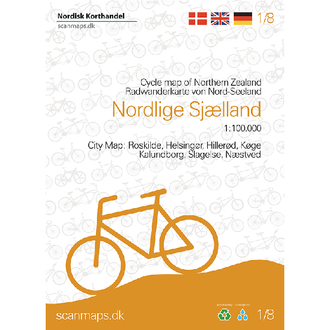
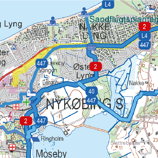
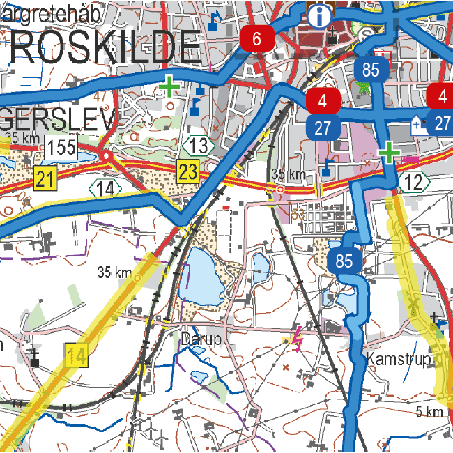
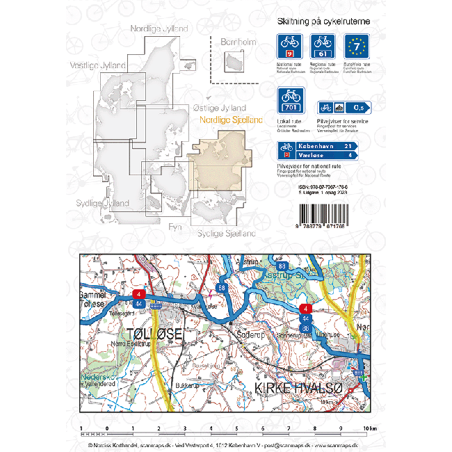
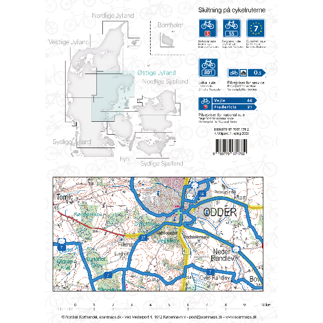
Sykkelkart 1 - Nordlige Sjælland
Ordinær pris 249,00 krThe maps contain: National cycle routes Regional cycle routes Local cycle routes, including the beautiful panorama routes. General information about accommodation, bike inclusion on trains etc. -Information icons on the map: Grocery stores outside major city, Tourist offices, National attractions, UNESCO world heritage, Bicycle friendly churches (special place for bike parking, water bottle filling etc., and a bicycle pump is available), Bike retailers, Beaches, Campsites, Hotels / Inns, Resting places, Hostels, Tent camps Ferry routes List of content is written in Danish, German and English.
Sykkelkart 2 - Sydlige Sjælland
Ordinær pris 249,00 krSykkelkart 3 - Fyn
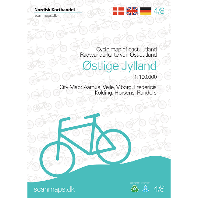
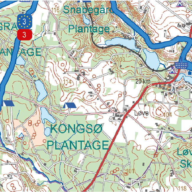
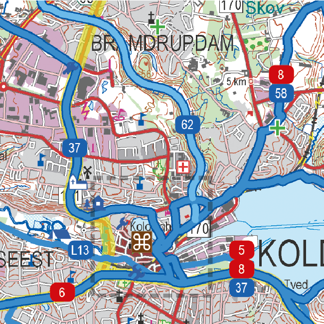
Ordinær pris 249,00 krSykkelkart 4 - Østlige Jylland
Ordinær pris 249,00 krSykkelkart 6 - Vestlige Jylland
Ordinær pris 249,00 krSykkelkart Danmark
Ordinær pris 249,00 krThe map of Denmark in the 4th edition now has bicycle maps on both sides of the map. In addition to the map of Denmark at a scale of 1: 500,000, you also get a bicycle map of Greater Copenhagen at a scale of 1: 35,000.
The map of Denmark contains a lot of information that is indispensable for a cycling holiday in Denmark. The map shows national and regional cycle routes, roads with cycle paths, hostels, campsites, tourist information, etc., and a Eurovelo map of the routes that run through Denmark is drawn. Information about the Danish cycling rules is included. There are over 160 regional and 11 national routes on the map, and new routes include the Culture Ring (East Jutland) and the West Region Route (Copenhagen).
The bicycle map is a planning map that provides an overview of cycling opportunities.
On the other side of the map you have a map of Greater Copenhagen at a scale of 1: 35,000, which is a detailed map of Copenhagen's cycle paths and cycle routes.
Syria & Lebanon
Ordinær pris 199,00 krGizi Map er en serie presise kart med detaljer og opplysninger over både populære og mindre populære reisemål. Dekker ofte områder der få andre kartprodusenter dekker.
Tahiti & French Polynesia
Ordinær pris 199,00 krAnyone who has visited Tahiti retains fond memories of a wonderful Polynesian paradise. This map shows the major islands of French Polynesia as a series of large insets on Side 1. An overall inset map showing the many islands is also shown, but for showing detail, one must expand the individual islands. The largest one is the volcanic Tahiti Nui, with the capital city of Pape’ete (or Papeete in English), for which a detailed inset map is included. Most visitors stay in the vicinity of Papeete, along the coast. We show several popular resorts. There is a good circular road around the island’s shoreline, but no roads in the interior. The island is joined to another, called Tahiti Iti, or Little Tahiti, and roads extend partway around this less-developed part of the combined island. Most of the other islands are rarely visited, although they have resorts, beaches, and a lifestyle of their own. Names like Huahine, Riatea, Tahaa, and Maiao may not be as familiar as they should be, but all can be reached by inter-island transportation. Moorea and Bora Bora are much better known, with numerous resorts along the coastline. Being a French Overseas Possession, Tahiti uses the Euro as a currency, so expect European prices! Tahiti is also a popular destination stop for cruise ships. The second side of the map covers a part of the world impossible to map well. The region known alternatively as Polynesia and as the South Pacific consists of a vast amount of water, dotted with small islands that are little more than the tips of mountains resting far below the surface. This map shows Hawaii at the upper edge and the northern tip of New Zealand at the bottom. The Queensland coast of Australia is at the far left, and the very isolated Pitcairn Islands at the eastern edge. In between are Cook Islands, Tahiti, Samoa, Fiji, the Solomons, Nauru, Kiribati, Micronesia, and the Marshall Islands. This vast expanse of ocean is becoming increasingly attractive as a cruise ship area, simply because it is the only way most of us could ever visit this region affordably. I like this map because it shows undersea mountain chains and names dozens of islands we’ve probably heard of and dreamed of visiting. Where exactly is Niue, for instance, or Fanning Island? Did you know that the USA has island colonial possessions all over the Pacific? Samoa is well known; how about Palmyra Atoll, Howland Island, the Bakers, or Swains Atoll? Lan has really created an enticing map; one looks at it in detail and starts making travel plans in one’s head!
Taiwan
Ordinær pris 169,00 krOur maps combine state-of-the-art, GPS-compatible cartography (including hypsometric tints and contour lines) with a detailed rendering of road networks and touristic information. They offer the best possible scale, level of detail and readability, be it a map of a small island or half a continent.
The maps feature a detachable paper sleeve so that the maps can be folded easily and fit in every pocket. Although printed on plastic, a special coating makes sure the maps retain a paper-like feel and can even be written on with a pencil.
Taiwan & Taipei
Ordinær pris 199,00 krTaiwan always reminds me of the “little engine that could”. Despite having to endure an extremely hostile neighbour, the country has prospered, is democratic, and is friendly and welcoming to visitors, despite the fact that most governments do not officially recognize its existence. Side 1 shows the capital city of Taipei, a bustling economic powerhouse on the Damshui River, close to the ocean. The city has numerous hotels and shopping areas, and a well-developed subway network.
The second side covers the complete island of Formosa from top to bottom in excellent detail, as well as the off-shore Penghu islands (these can be reached by ferries from Kaohsung or Dongshih). Most of the country’s development is on the western, or Taiwan Straits, side of the mountainous country, but to me the Taroka Gorge, leading inland from Hualien on the east coast, is one of the wonders of modern Asia. An inset map of Tainan in southeast Taiwan is also included.