Filter
- Albania
- Andorra
- Angola
- Argentina
- Armenia
- Aserbajdsjan
- Australia
- Bahrain
- Bangladesh
- Belgia
- Belize
- Benin
- Bhutan
- Bolivia
- Bosnia-Hercegovina
- Botswana
- Brasil
- Brunei
- Bulgaria
- Burundi
- Canada
- Chile
- Colombia
- Costa Rica
- Cuba
- Danmark
- Djibouti
- Dominica
- Ecuador
- Ekvatorial-Guinea
- El Salvador
- Eritrea
- Estland
- Eswatini
- Etiopia
- Finland
- Frankrike
- Gabon
- Gambia
- Georgia
- Guyana
- Hellas
- Honduras
- Hviterussland
- India
- Indonesia
- Irak
- Iran
- Irland
- Island
- Italia
- Jamaica
- Japan
- Kambodsja
- Kamerun
- Kasakhstan
- Kenya
- Kina
- Kirgisistan
- Kongo
- Kosovo
- Kroatia
- Kuwait
- Kypros
- Laos
- Latvia
- Lesotho
- Libanon
- Libya
- Litauen
- Luxembourg
- Malawi
- Malaysia
- Maldivene
- Mali
- Marokko
- Mauritania
- Mauritius
- Mexico
- Moldova
- Monaco
- Mongolia
- Montenegro
- Mosambik
- Namibia
- Nederland
- Nepal
- New Zealand
- Nicaragua
- Niger
- Nigeria
- Nord-Makedonia
- Norge
- Oman
- Pakistan
- Panama
- Papua Ny-Guinea
- Paraguay
- Peru
- Polen
- Portugal
- Romania
- Russland
- Rwanda
- Samoa
- Senegal
- Serbia
- Sierra Leone
- Singapore
- Slovakia
- Slovenia
- Somalia
- Spania
- Sri Lanka
- Storbritannia
- Surinam
- Sveits
- Sverige
- Sør-Afrika
- Sør-Korea
- Taiwan
- Thailand
- Togo
- Tsjekkia
- Tunisia
- Turkmenistan
- Tyrkia
- Tyskland
- Uganda
- Ungarn
- USA
- Usbekistan
- Venezuela
- Vietnam
- Østerrike
895 produkter
895 produkter

Italia
Ordinær pris 199,00 kr/
Mva inkludert
Frakt beregnes i kassen.
- Publisert: 2023
- Innbinding: Falset
- Materiale: Papir
- Målestokk: 1:800 000

Italy
Ordinær pris 119,00 kr/
Mva inkludert
Frakt beregnes i kassen.
Lonely Planet Planning Map er slitesterkt og vanntett, med en hendig slipcase og et format som er enkelt å brette. Få mer ut av kartet og reisen din med bilder og informasjon om toppattraksjoner i landet, reiseruteforslag, en transportguide, planleggingsinformasjon, temalister og praktiske reisetips. Med dette brukervennlige navigasjonsverktøyet i baklommen kan du virkelig komme til hjertet av din destinasjon!
- Publisert: April, 2025
- Utgave: 2.utg
- Innbinding: Falset
- Material: Plast papir
- ISBN: 9781787015852

Italy: Emilia-Romagna
Ordinær pris 199,00 kr/
Mva inkludert
Frakt beregnes i kassen.
This detailed road map of Emilia-Romagna - Bologna is very suitable for planning and traveling around the country. The road network is well represented, both the main roads, provincial and local roads. Road numbers are also clearly stated.
Distances between places are marked on the map in kilometers, and gas stations are also marked in important places. Shadow shows the relief and sometimes some points with the actual height. Province borders, national parks and reserves are easy to find.
Symbols indicate the location of tourist sites, monuments, historically important places and viewpoints. In certain places you can find hotels and campsites, airports, train connections and ports.
- Publisert: 2024
- Innbinding: Falset
- Materiale: Papir
- Målestokk: 1:150 000

Italy: Friuli Julian March - Udine; Trieste & Venice
Ordinær pris 199,00 kr/
Mva inkludert
Frakt beregnes i kassen.
Italian region of Friuli–Venezia Giulia at a detailed scale of 1:150,000 on a map in Freytag & Berndt’s very popular “Top 10 Tips” series. A booklet attached to the map cover provides descriptions of the region’s 10 best sights, a street plan of central Trieste, plus the map index. Many place names are in large print to make navigating easier. Coverage extends west to Belluno and Treviso, and south-west to include the Venice Lagoon with Venice and Chioggia.
Maps in this series have topography well presented by subtle hill-shading with spot heights, plus colouring for woodlands; national and regional parks are highlighted. Road network emphasizes motorways and regional roads, but also includes small local roads and selected country tracks, most annotated with driving distances. Scenic routes are highlighted and the maps show roads closed to motor vehicles and/or not recommended for caravans, winter closures, toll routes, etc. Names of larger local towns are in bold print, making navigating in unfamiliar terrain much easier. Railway lines and ferry routes are included and local airports are marked.
Picturesque locations are highlighted and in each title 10 best places of interest are prominently marked and briefly described in a booklet attached to the map cover. Symbols indicate various landmarks and facilities, e.g. archaeological sites, churches and castles, campsites, hostels, etc. Latitude and longitude lines are drawn at 10' intervals. The index, listing all the localities with their postcodes, is in the booklet attached to the map cover. The booklet also provides street plan (s) of the region’s main town(s). Map legend and the descriptions include English.
- Publisert: 2023
- Innbinding: Falset
- Materiale: Papir
- Målestokk: 1:150 000

Italy: Liguria
Ordinær pris 199,00 kr/
Mva inkludert
Frakt beregnes i kassen.
- Publisert: 2025
- Innbinding: Falset
- Materiale: Papir
- Målestokk: 1:200 000

Italy: Puglia
Ordinær pris 199,00 kr/
Mva inkludert
Frakt beregnes i kassen.
Dette store østerriske kartforlaget er kjent for sin klare kartografi og gode papirkvalitet. De kommer i alle målestokker, og flere av landkartene inneholder bykart og turistinformasjon.
- Publisert: 2023
- Innbinding: Falset
- Materiale: Papir
- Målestokk: 1:150 000

Italy: Pustertal Dolomiten
Ordinær pris 209,00 kr/
Mva inkludert
Frakt beregnes i kassen.
Dette store østerriske kartforlaget er kjent for sin klare kartografi og gode papirkvalitet. De kommer i alle målestokker, og flere av landkartene inneholder bykart og turistinformasjon.
- Publisert: 2024
- Innbinding: Falset
- Materiale: Vannfast papir
- Målestokk: 1:50 000

Italy: Sardinia
Ordinær pris 199,00 kr/
Mva inkludert
Frakt beregnes i kassen.
Indexed, waterproof and tear-resistant road map of Sardinia at 1:200,000 with topographic and tourist information, published by Reise Know-How as part of their highly acclaimed World Mapping Project. The map is double-sided, with a good overlap, to provide the best balance between a good scale and a convenient size sheet.
Topography is indicated by altitude colouring with spot heights and names of mountain ranges. Road information includes local tracks, indicates driving distances on main and secondary roads, and highlights scenic routes. Railways and ferry connections are also shown. Extensive overprint indicates locations of numerous nuraghi/nuraghes, the main type of megalithic edifices found in Sardinia, dating back before 1000 BC and today a symbol of the island’s distinctive culture. The overprint also highlights local national parks, holiday camps, campsites and mountain refuges, viewpoints, prehistoric monuments, churches and castles, beaches, golf courses, etc. The map has a 10km UTM grid, plus latitude and longitude grid at 10’ intervals. Map legend includes English.
- Publisert: 2024
- Innbinding: Falset
- Materiale: Plastpapir
- Målestokk: 1:200 000


Italy: Sicily; Sardinia & The South
Ordinær pris 169,00 kr/
Mva inkludert
Frakt beregnes i kassen.
ITM har kart over hele verden og de spesialiserer seg på land litt utenfor allfarvei. Beliggenheten til landets nasjonalparker, historiske monumenter, de viktigste veiene og lignende finner du inkludert i kartene. Samtlige landkart har ofte et bykart over hovedstaden.
- Publisert: 2023
- Innbinding: Falset
- Materiale: Plastpapir
- Målestokk: 1:600.000

Italy: South & Central
Ordinær pris 179,00 kr/
Mva inkludert
Frakt beregnes i kassen.
We had previously issued a map of Italy North at this same scale to provide more detail than is possible on the country map. This map continues the process of showing Italy to advantage. Side one covers from Umbria Province north of Rome to below Naples and east to the Adriatic between Ancona and Brindisi. An inset map of Sardinia is also included. The second side covers the 'toe' of Italy, the island of Sicily, and several small islands in the Mediterranean. Italy is densely populated and has a complicated road/rail system.
This map expands the southern half of the country into a comprehensive whole, showing motorways in blue, mian roads in green, World Heritage sites, castles, and major churches. Italy is rich in history and marvelous attractions and is the type of country where one wanders, rather than travels, in exploration. ITMB also publishes a more detailed map of Sicily as a separate title, and hopes to publish one of Sardinia later this year. We also publish an excellent city map of Rome. Earlier in 2020, we spent a week in the Naples/Pompei/Amalfi area. There was so much to see that we never got south of Potenza.
- Publisert: 2020
- Innbinding: Falset
- Materiale: Papir
- Målestokk: 1:600 000

Jamaica
Ordinær pris 169,00 kr/
Mva inkludert
Frakt beregnes i kassen.
Tysk kartserie med flotte kart på slitesterkt plastpapir.
Publisert år: 2018
Innbinding: falset
Material: Plastpapir
Målestokk: 1:150,000

Jamaica & Cayman Islands
Ordinær pris 149,00 kr/
Mva inkludert
Frakt beregnes i kassen.
ITM har kart over hele verden og de spesialiserer seg på land litt utenfor allfarvei. Beliggenheten til landets nasjonalparker, historiske monumenter, de viktigste veiene o.L. Finner du inkludert i kartene. Samtlige landkart har ofte et bykart over hovedstaden.
Fra ITM: This map was called Cayman Islands and Jamaica in its previous edition, which was a well-intentioned attempt to promote the smaller islands adjacent to big brother. Now, we are reverting to what we think is a more logical title arrangement for listing purposes, but the map has two covers, so one can market it as either Jamaica or the Caymans, or best of all, market both! We visited the Caymans a few months ago and drove every road on the main island, including a few that turned out to be driveways! The map is very current as a result. The other side of the map is the very popular touristic island of Jamaica, now into its sixth edition. This island is large enough to justify renting a car and exploring. It is a great way to discover hidden coves and find historic plantations, especially along the touristic north shore. 6th/3rd Ed. 1:250,000/1:37,500
Publisert år: 2017
Innbinding: falset
Material: papir
Målestokk: 1:250000/37,500


Japan
Ordinær pris 219,00 kr/
Mva inkludert
Frakt beregnes i kassen.
Japan at 1:1,200,000 on an indexed, waterproof and tear-resistant road map with topographic and tourist information, published by Reise Know-How as part of their highly acclaimed World Mapping Project. The map is double-sided to provide the best balance between a good scale and a convenient size sheet, with a generous overlap; Tokyo and Nagoya are included on both sides. The southern islands including Okinawa are on an inset. Names of the islands and main towns are in both scripts, with names of smaller towns and villages, provinces and geographical features given in the Latin alphabet only.
Highly tear-resistant and 100% waterproof map "Japan" from the series world mapping project.
Reise Know-How maps are characterized by particularly sturdy plastic paper, which can be written on like paper, even with a pencil. The cardboard envelope is removable, making it easy to put the card in any pocket. A protective cover is not required. The cartographic representation focuses on the most important information for travellers and is particularly easy to read. Instead of shading, coloured layers of elevation are used.
- Publisert: 2025
- Innbinding: Falset
- Materiale: Plastpapir
- Målestokk: 1:1 200 000

Japan: Mount Fuji / Kanto & Chubu regions
Ordinær pris 169,00 kr/
Mva inkludert
Frakt beregnes i kassen.
The volcanic cone of Mount Fuji is Japan's most popular touristic attraction. Located a shoer train ride west of Tokyo, Fuji attracts millions of visitors each year. Side 1 focuses on the mountain itself, showing rail connections, surrounding towns, roads on the lower slopes, hiking trails, and accommodations close to the summit. Side 2 shows the kata & Chubu Regions from Tokyo to Nagoya and north to Nigata. This is a brand new ITMB title.
- Publisert: 2021
- Materiale: Papir
- Innbinding: Falset
- Målestokk: 1:600 000, 1:65 000


Kathmandu Valley
Ordinær pris 199,00 kr/
Mva inkludert
Frakt beregnes i kassen.
- Publisert: 1998
- Innbinding: Falset
- Materiale: Papir
- Målestokk: 1:50 000

Kazakhstan
Ordinær pris 199,00 kr/
Mva inkludert
Frakt beregnes i kassen.
Indexed, waterproof and tear-resistant road map of Kazakhstan and the northern half of Kyrgyzstan at 1:2,000,000 with topographic and tourist information, published by Reise Know-How as part of their highly acclaimed World Mapping Project. The map is double-sided to provide the best balance between a good scale and a convenient size sheet.
Road and rail networks are easy to see on a clear base which shows the area’s topography by altitude colouring with contours, spot heights, mountain passes and names of mountain ranges. Internal administrative boundaries are shown with names of the provinces. Road network includes unsurfaced roads and seasonal tracks. A wide range of symbols highlights various places of interest, including UNESCO heritage sites, the route of the Silk Road, museums and archaeological remains, selected hotels, beaches, winter sports areas, etc. National parks and protected areas are prominently shown. Also marked are oil and natural gas wells and pipelines. The map has a latitude and longitude grid at intervals of 1° and an index of place names with a separate list of national parks. Map legend includes English.
- Publisert: 2025
- Innbinding: Falset
- Materiale: Plastpapir
- Målestokk: 1:2 000 000

Kazakhstan, Kyrgyzstan, Tajikistan, Turkmenistan, Uzbekistan
Ordinær pris 199,00 kr/
Mva inkludert
Frakt beregnes i kassen.
Gizi Map er en serie presise kart med detaljer og opplysninger over både populære og mindre populære reisemål. Dekker ofte områder der få andre kartprodusenter dekker.
- Publisert: 2020
- Innbinding: Falset
- Materiale: Papir
- Målestokk: 1:3 000 000

Kefalonia
Ordinær pris 229,00 kr/
Mva inkludert
Frakt beregnes i kassen.
Kefalonia was popularised and made famous by Captain Corelli's Mandolin. For your best adventures, use the best map. Water-proof, split-proof, tear-proof, adventure-proof.
Kefalonia and Ithaca Tour and Trail Super Durable Map is simply the toughest, most accurate, easy to read, easy to use map of the island you can buy at any price. A large 960mm by 690mm double sided map sheet has both Kefalonia and Ithaca at 1:40,000 scale with the North-West of Kefalonia on the cover side and the South-East of Kefalonia with neighbouring island Ithaca on the reverse. A generous common overlap of Kefalonia reduces the need to turn the map over when navigating.
Our special concertina map fold makes your map easy to open and easy to refold to its 230mm by 120mm pocket size. Our legendary 'Tour & Trail' level of detail ranges from major roads to secondary roads to minor roads to streets and narrow country roads, plus dirt roads, tracks and walking trails. Place names are in English and Greek to aid your navigation.
Altitude shading is designed to clearly show the altitude range when travelling across the island by car or on foot. 20 metre and 100 metre contours combined with altitude shading bring this beautiful landscape to life. There are plenty of individual height points and all of the official Trig points are on the map.
Tour and Trail attention to detail includes our useful symbol range including viewpoints, picnic areas, petrol stations, bar/restaurants and parking areas where you can pull off the road safely. You will easily identify springs, caves, sports grounds, cemeteries, monasteries, churches, chapels, lighthouses, castles, camping areas, wind turbines, hotels etc. Published walking routes are clearly highlighted on the map.
It all adds up to the most detailed and most durable map of Kefalonia and Ithaca that you can buy anywhere. Super Durable means a waterproof, tear-proof, map that can take the roughest treatment and still folds up like new after your adventures. Super Durable Maps come with a 2 year adventurous use Wear and Tear guarantee.
Digital editions of our Kefalonia and Ithaca Tour and Trail Map are available for phone apps and Garmin users from our Discovery Walking Guides website.
Publisert år: 2020
Innbinding: fal
Material: 0
Målestokk: 1:40 000

Kosovo
Ordinær pris 199,00 kr/
Mva inkludert
Frakt beregnes i kassen.
Kosovo at 1:150,000 on a large map in Freytag & Berndt’s “Top 10 Tips” series with the index booklet also providing multilingual descriptions of the country’s most interesting locations. Where appropriate, place names are bilingual, with Serbian names shown in Latin alphabet only (within Serbia itself and Macedonia place names are in both Cyrillic and Latin alphabets).
The map is an enlargement of F&B’s mapping of the region at a smaller scale, so all names are in much larger print size than found on similar maps. Topography is presented by relief shading with colouring for forested areas, plus names of various mountain ranges and peaks. Road network includes small local roads and selected cart tracks. Driving distances are marked on main routes and scenic roads are highlighted. Railway lines are shown with stations. Various places of interest, including the publishers’ recommendations are highlighted. Latitude and longitude lines are drawn at 10’ intervals. Multilingual map legend includes English.
- Publisert: 2024
- Innbinding: Falset
- Materiale: Papir
- Målestokk: 1:150 000


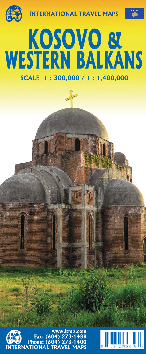
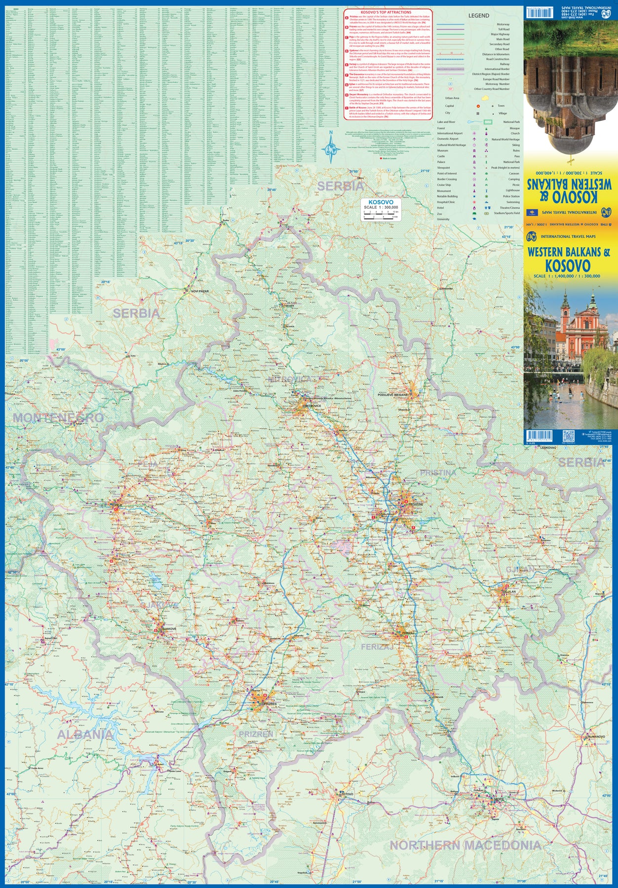
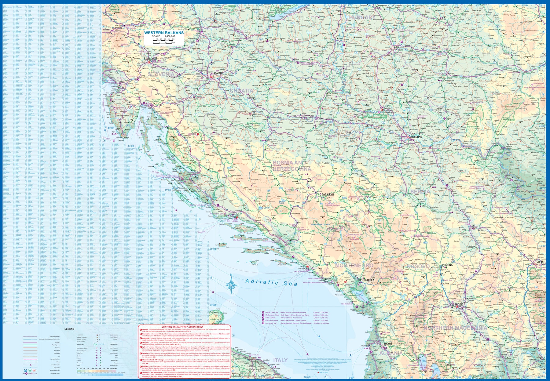
Kosovo & Western Balkans
Ordinær pris 199,00 kr/
Mva inkludert
Frakt beregnes i kassen.
Kosovo is the country that shouldn't exist, but does. When Yugoslavia fell to pieces after Tito died, Kosovo was lumped in with Serbia but was very unhappy with being a part of an Eastern Orthodox regime. It broke away, resulting in genocidal fighting until the Americans stepped in and stopped the fighting. The region was then placed under a European Union control in the faint hope that it would merge with Albania, or Montenegro, but it didn't. Relations with Serbia are still quite strained, but Kosovo is still surviving as a mountainous Balkan state. Fought over for centuries by Turks and Serbs, Kosovo is emerging as a small but touristic European country. This is definitely an off-the-beaten-path travel destination!
The second side of the sheet provides an excellent regional coverage for the Western Balkans, essentially Slovenia, Croatia, Montenegro, Serbia, and reasonably large tracks of land for Hungary, Albania, and North Macedonia, showing the growing number of wilderness parks being created.
- Publisert: 2023
- Innbinding: Falset
- Materiale: Papir
- Målestokk: Kosovo 1:300 000 - Balkans 1:1 400 000

La Palma Caldera de Taburiente
Ordinær pris 199,00 kr/
Mva inkludert
Frakt beregnes i kassen.
Publisert år: 2018
Innbinding: falset
Material: papir
Målestokk: 1:25000
Innbinding: falset
Material: papir
Målestokk: 1:25000

Lake District & Cumbria
Ordinær pris 119,00 kr/
Mva inkludert
Frakt beregnes i kassen.
Lonely Planet Planning Map er slitesterkt og vanntett, med en hendig slipcase og et format som er enkelt å brette. Få mer ut av kartet og reisen din med bilder og informasjon om toppattraksjoner i landet, reiseruteforslag, en transportguide, planleggingsinformasjon, temalister og praktiske reisetips. Med dette brukervennlige navigasjonsverktøyet i baklommen kan du virkelig komme til hjertet av din destinasjon!
- Publisert: Juni, 2025
- Utgave: 2.utg
- Innbinding: Falset
- Material: Plast papir

Langthang Himal East
Ordinær pris 279,00 kr/
Mva inkludert
Frakt beregnes i kassen.
Alpeinvereinskarte er en serie detaljerte vandre- og klatrekart over de østeriske og tyske alper. Høy kvalitet og nøyaktig kartografi gjør disse kartene avgjørende for den erfarene klatrer og fjellturist. Fjellhytter, turstier og campingplasser er tydelig markert på kartene. Noen av kartene er også utgitt i egne skiutgaver.
Publisert år: 1990
Målestokk: 1:50000