Filter
- Albania
- Andorra
- Angola
- Argentina
- Aserbajdsjan
- Australia
- Bahamas
- Bahrain
- Bangladesh
- Belgia
- Belize
- Benin
- Bolivia
- Bosnia-Hercegovina
- Brasil
- Brunei
- Bulgaria
- Burundi
- Canada
- Chile
- Costa Rica
- Cuba
- Danmark
- Djibouti
- Dominica
- Ecuador
- El Salvador
- Eritrea
- Estland
- Eswatini
- Etiopia
- Fiji
- Finland
- Frankrike
- Guyana
- Hellas
- Honduras
- Hviterussland
- India
- Indonesia
- Irak
- Iran
- Irland
- Island
- Italia
- Jamaica
- Japan
- Kambodsja
- Kasakhstan
- Kenya
- Kina
- Kirgisistan
- Kongo
- Kosovo
- Kroatia
- Kuwait
- Laos
- Latvia
- Lesotho
- Libanon
- Libya
- Liechtenstein
- Litauen
- Luxembourg
- Malawi
- Malaysia
- Mali
- Malta
- Marokko
- Mauritania
- Mauritius
- Mexico
- Mongolia
- Montenegro
- Mosambik
- Nederland
- Nepal
- New Zealand
- Nicaragua
- Niger
- Nigeria
- Nord-Makedonia
- Norge
- Oman
- Pakistan
- Panama
- Paraguay
- Peru
- Polen
- Portugal
- Romania
- Russland
- Rwanda
- Samoa
- San Marino
- Serbia
- Sierra Leone
- Singapore
- Slovakia
- Slovenia
- Solomonøyene
- Somalia
- Spania
- Sri Lanka
- Storbritannia
- Surinam
- Sveits
- Sverige
- Sør-Korea
- Taiwan
- Thailand
- Togo
- Tonga
- Tsjekkia
- Tunisia
- Turkmenistan
- Tyskland
- Uganda
- Ukraina
- Ungarn
- Uruguay
- USA
- Usbekistan
- Vanuatu
- Venezuela
- Vietnam
- Østerrike
753 produkter
753 produkter


Mexico
Ordinær pris 189,00 kr/
Mva inkludert
Frakt beregnes i kassen.
ITM har kart over hele verden og de spesialiserer seg på land litt utenfor allfarvei. Beliggenheten til landets nasjonalparker, historiske monumenter, de viktigste veiene og lignende finner du inkludert i kartene. Samtlige landkart har ofte et bykart over hovedstaden.
Fra ITM: Mexico is a fascinating country, and as travel re-opens, is proving to be very popular. This most recent edition was recently printed, and is now the current edition. Double sided detailed travel map, with comprehensive place name index. Distinguishes roads ranging from expressways (free/toll) to rural roads. Legend includes railways, tracks, trails, international airports, domestic airports, bridges, border crossing points, points of interest, archaeological sites, beaches, active volcanos, filling stations, national parks, deserts, places of touristic interest. Printed on durable, water-resistant plastic paper, suitable for travelling in areas with extreme humidity. This is another chestnut in the ITMB line, and sells well. The cover picture is new, as is the ISBN. Mexico is a very large and diverse country, and very popular with Americans. Again, there is little one can say that is news about such a tried-and-true map, except to say that it is extremely popular.
- Publisert: 2024
- Innbinding: Falset
- Materiale: Plastpapir
- Målestokk: 1:2 000 000

Mexico
Ordinær pris 189,00 kr/
Mva inkludert
Frakt beregnes i kassen.
Dette store østerriske kartforlaget er kjent for sin klare kartografi og gode papirkvalitet. De kommer i alle målestokker, og flere av landkartene inneholder bykart og turistinformasjon.
Publisert år: 2018
Innbinding: falset
Material: papir
Målestokk: 1:2000000

Mexico
Ordinær pris 199,00 kr/
Mva inkludert
Frakt beregnes i kassen.
Mexico at 1:2,250,000 on an indexed, waterproof and tear-resistant road map with topographic and tourist information, published by Reise Know-How as part of their highly acclaimed World Mapping Project. The map is double-sided, with a very generous overlap between the sides, to provide the best balance between a good scale and a convenient size sheet. Coverage extends south to include the whole of Belize, most of Guatemala (well past Guatemala City) and north-western Honduras including Tegucigalpa.
Topography is presented by altitude colouring and spot heights with names of mountain ranges, peaks, etc. Swamp areas, mangroves, seasonal rivers and lakes, and along the coast coral reefs are also indicated. National parks and other protected areas are highlighted. Road network indicates toll routes, includes selected local roads and tracks, and shows border crossings and distances on main routes. Railway lines are included and local airports are marked. Internal administrative boundaries are shown with names of the provinces. Symbols indicate numerous places of interest, including UNESCO world heritage sites and archaeological remains, etc. The map has a latitude and longitude grid at intervals of 2° and an extensive index of localities. Map legend includes English.
- Publisert: 2023
- Innbinding: Falset
- Materiale: Plastpapir
- Målestokk: 1:2 250 000

Mexico: Chihuahua & Coahuila
Ordinær pris 169,00 kr/
Mva inkludert
Frakt beregnes i kassen.
ITM har kart over hele verden og de spesialiserer seg på land litt utenfor allfarvei. Beliggenheten til landets nasjonalparker, historiske monumenter, de viktigste veiene o.L. Finner du inkludert i kartene. Samtlige landkart har ofte et bykart over hovedstaden.
Fra ITM: Northern Mexico is a vast desert-like plateau deeply steeped in Spanish colonial heritage. The very first settlement inside what is now the USA was the town of Presidio (long before the English thought of settling Jamestown) and is still one of the few crossings of the Rio Grande into Texas (itself a former Mexican province). There are two major cities in the region, Chihuahua, 300 kms south of El Paso, and Monterrey, the largest city in northern Mexico. There are major touristic attractions at Monclova, Saltillo, Parras, Torreon, and Cuauhtemoc, the end of the famous Copper Canyon rail line. The map extends a bit into Sinaloa, to include Los Mochis on the Pacific coastline. The entire rail line is also shown. This is an important part of North American history. It may not be as well-known to Europeans who favour the beaches of the Yucatan, but it is a fascinating part of Mexico on the American border. Ciudad Juarez, for example, is larger than its partner on the Rio Grande, El Paso. An inset map of the old colonial city of Saltillo is included, as well as our Top Attractions list.
Publisert år: 2022
Innbinding: falset
Material: papir
Målestokk: 1:750000


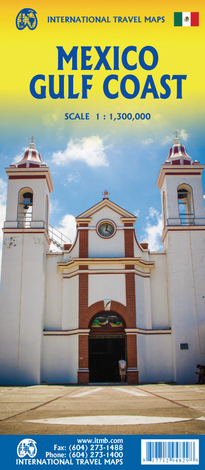
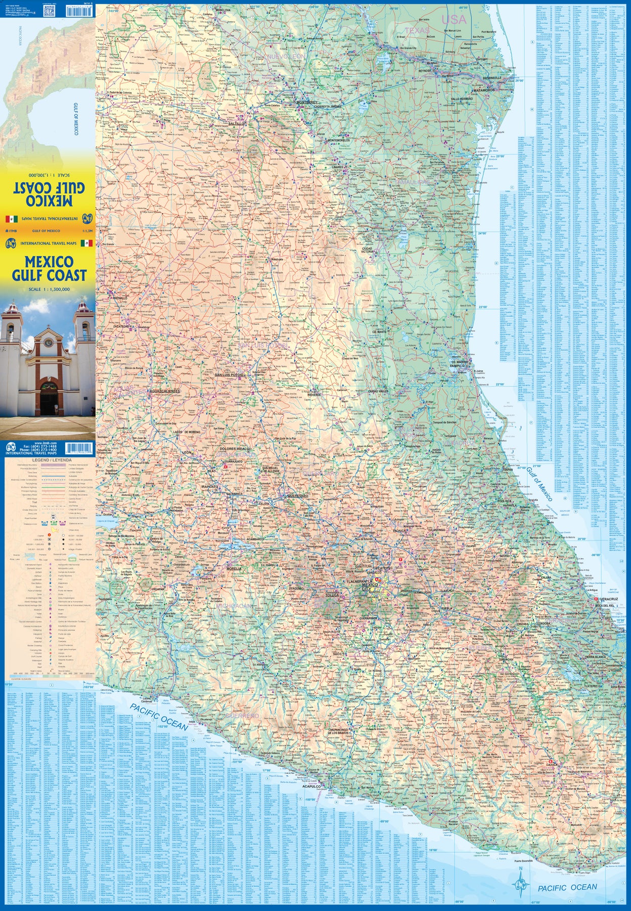
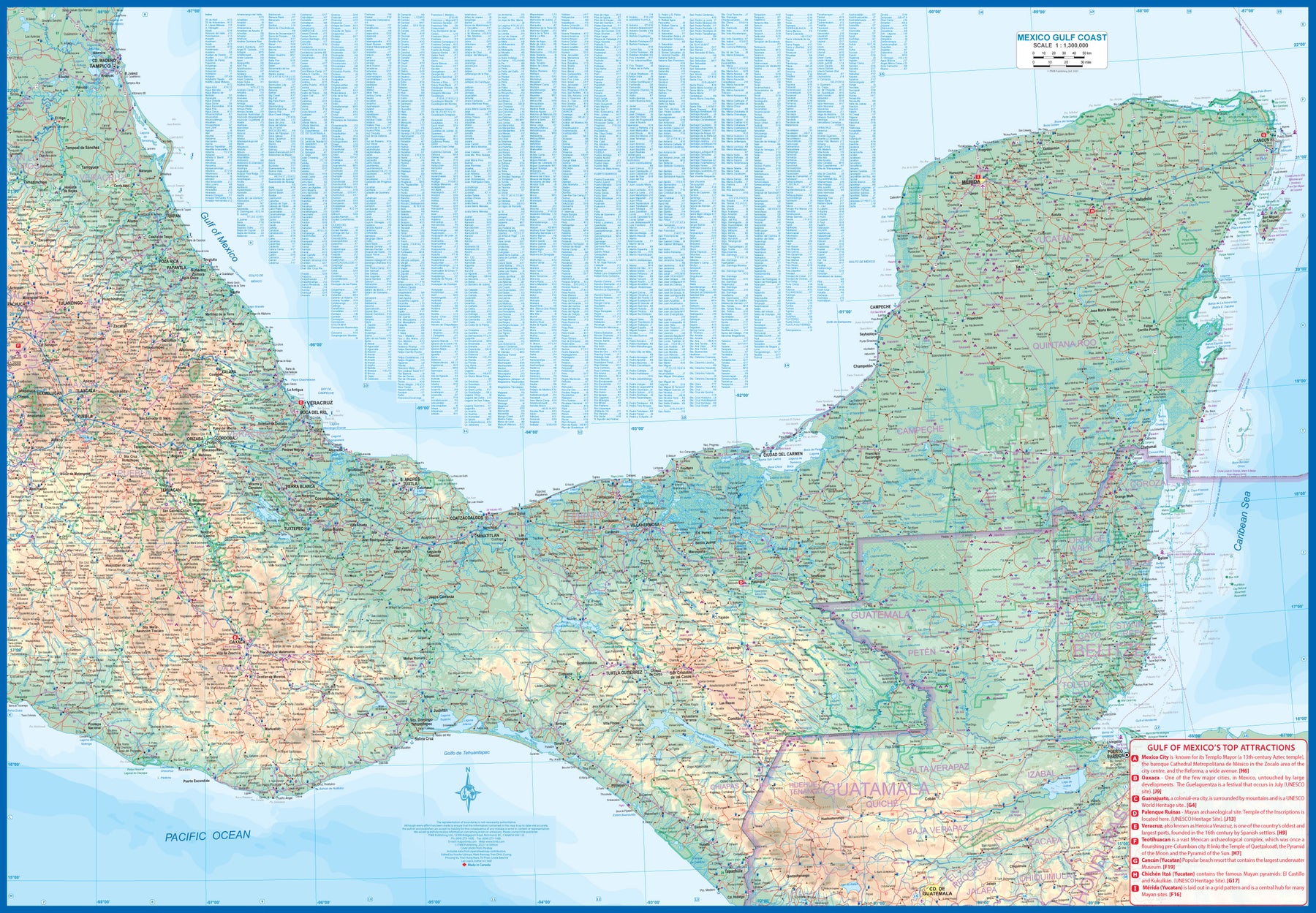
Mexico: Gulf Coast
Ordinær pris 169,00 kr/
Mva inkludert
Frakt beregnes i kassen.
Mexico is an ever-popular travel destination. The country is so large that we started mapping it as a series of regional maps years ago. The Gulf Cost extends from Brownsville, Texas through Vera Cruz to the Yucatan Peninsula. Due to the shape of the region, all of Belize and about half of Guatemala is included, but the focus is on the many attractions of the eastern Gulf coast of Mexico. Side 1 cover the northern coastal regions, going inland as far as Monterrey, Zacatecas, Morelia, and Mexico City.
Side 2 shows the Gulf Coast from Tampico to Carmen, then on to Merida, Cancun, and the southern tip of Belize. By the shape of this part of Mexico, the Pacific Coast, from the Guatemalan border westwards past Acapulco is also shown. All major roads are shown, but as passenger rail service was discontinued several years ago, we have opted to not show most rail lines. This is a map for explorers and adventurers to discover by driving. It covers all of historic Mexico and complements other ITMB maps detailing regions of a fascinating country, where the first word you learn is 'Hola!'
- Publisert: Januar 2023
- Innbinding: Falset
- Materiale: Papir
- Målestokk: 1:1 300 000


Mexico: Mexico Central
Ordinær pris 199,00 kr/
Mva inkludert
Frakt beregnes i kassen.
Mexico is an exceptionally interesting country to visit. The country itself is larger than most people realize, making sectional maps essential. We started mapping Mexico in the late 1980s and have gradually added regional maps as time and money enabled. Naturally, touristy popular areas like the Yucatan, Baja, and the Pacific Coast really need specialized maps, but so does the central region of the country. This map covers from Mexico City south to Acapulco and east almost as far as the Guatemalan border on side 1, and from Puebla west to Guadalajara on side 2.
Highlights include the colonial mining town of Taxco, the ruins of the Aztec capital of Teotihuacan, the untouched historical city of Oaxaca, and the mountain centre of Tuxtla Gutierrez. This is a map for driving and exploring and coming to understand one of the most important countries in the Americas.
- Publisert: 2024
- Innbinding: Falset
- Materiale: Papir
- Målestokk: 1:900 000


Mexico: Mexico City & Mexico Central
Ordinær pris 179,00 kr/
Mva inkludert
Frakt beregnes i kassen.
ITM har kart over hele verden og de spesialiserer seg på land litt utenfor allfarvei. Beliggenheten til landets nasjonalparker, historiske monumenter, de viktigste veiene og lignende finner du inkludert i kartene. Samtlige landkart har ofte et bykart over hovedstaden.
Fra ITM: Mexico City is the largest city in the Americas, with a population of about 30 million. Our map concentrates on the core of the city, which is where hotels, attractions, and touristic interest abounds, from the train station in the north to the university in the south and from the huge bus station in the east to Chapultepec Park in the west. Insets of the metropolitan area and of the rapid transit network are included. The second side contains a detailed regional map of that part of Mexico deemed to be ‘central’; essentially, from Pueblo in the east to Guadalajara in the west and from Taxco in the south to San Luis Potosi in the north. Top attractions include San Miguel de Allende, Guanajuato, the Great Pyramid of Cholula, and the colonial city of Puebla.
- Publisert: 2024
- Innbinding: Falset
- Materiale: Papir
- Målestokk: 1:900 000, 1:12 000


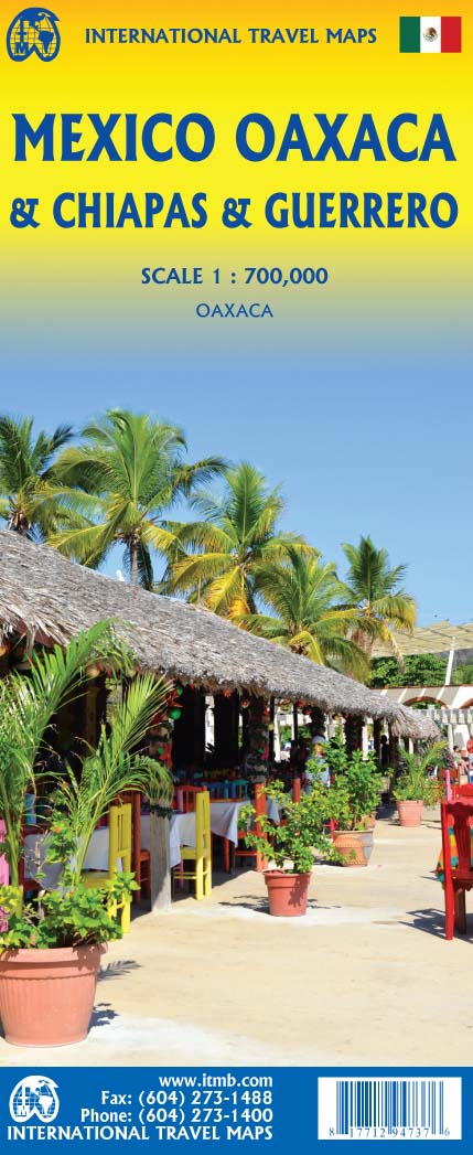
Mexico: Oaxaca & Chiapas & Guerrero
Ordinær pris 169,00 kr/
Mva inkludert
Frakt beregnes i kassen.
ITM har kart over hele verden og de spesialiserer seg på land litt utenfor allfarvei. Beliggenheten til landets nasjonalparker, historiske monumenter, de viktigste veiene o.L. Finner du inkludert i kartene. Samtlige landkart har ofte et bykart over hovedstaden.
Fra ITM: Travel to Mexico is exploding at the moment, as Covid restrictions lift. That portion of Mexico that forms the relatively narrow land mass between Mexico City and the Yucatan Peninsula is called the Isthmus of Mexico. It consists of three states, Oaxaca, in the west, Chiapas in the east, and Guerrero in the west. This is a double-sided map, stretching from west of Acapulco to beyond the border with Guatemala along the Pacific coast, and from Veracruz to Carmen along the Gulf of Mexico coast. It is the part of Mexico containing numerous holiday resort areas for sun-lovers, but is also rich in history and attractive colonial-era towns.
Oaxaca City is a UNESCO World Heritage site, as is the Mayan temple site of Palenque. There are numerous archeological sites in the region to explore, such as Monte Alban, which dates from the 8th Century BC. The colourful mining town of Taxco, with its narrow cobblestone streets, is a must-see, as is San Cristobal de Las Casas, in Chiapas State. This is an extremely popular part of Mexico to visit, so we are very pleased to be able to bring it back into print.
- Publisert: 2020
- Innbinding: Falset
- Materiale: Papir
- Målestokk: 1:700 000

Mexico: Sonora & Sinaloa
Ordinær pris 169,00 kr/
Mva inkludert
Frakt beregnes i kassen.
ITM har kart over hele verden og de spesialiserer seg på land litt utenfor allfarvei. Beliggenheten til landets nasjonalparker, historiske monumenter, de viktigste veiene og lignende finner du inkludert i kartene. Samtlige landkart har ofte et bykart over hovedstaden.
Fra ITM: The northern Pacific coastline of Mexico borders on California and Arizona and is a popular travel destination. Sonora is the more northerly state of Mexico, bordering on Baja California on its west (much of which is included on this map) Nogales is probably the best-known city, although Hermosillo is the capital. Sinaloa is more southerly, and is probably best known for Mazatlán, the popular ocean resort community and cruise ship port of call. Sinaloa is also the starting point for the famous train excursion known as the Copper Canyon, originating in Los Mochis. The rail route is shown on the map. The canyon is actually in Chihuahua State, which is included on this map, and goes through a portion of Mexico that is pretty much devoid of roads. The trip ends in Cuauhtémoc, but users are advised to stay on the train to the capital city, also called Chihuahua. We have included the top ten attractions of the region, including the Pinacate Volcanic Field, the Nacapule Canyon, and Las Labradas World Heritage site. This is a part of Mexico easy to reach from the USA, and has many attractive cities
- Publisert: 2019
- Innbinding: Falset
- Materiale: Papir
- Målestokk: 1:800 000

Mexico; Guatemala; Belize & El Salvador
Ordinær pris 169,00 kr/
Mva inkludert
Frakt beregnes i kassen.
Marco polo er svært detajerte kart som er praktiske og enkle i bruk. 7 klistremerker for å markere spesifikke steder gjør det enda enklere å planlegge reisen. Alle kartene inneholder en omfattende index for enkelt å finne frem.
Let the Marco Polo Mexico Map guide you around this fascinating country. Discover a diverse landscape of mountains, deserts and jungles, ancient ruins, colonial towns and incredible beaches with this highly durable touring map of Mexico. It folds away easily and is always on standby to help when you're stuck.
Perfect touring map - the scale is 1 : 2 500 000* ideal to help you plan your overall route and navigate the main highways by car, RV or campervan.
Easy to use - the super clear mapping in strong colours and clear text will help you navigate the region.
Includes 5 city maps - detailed street maps of key cities are included as well as coverage of Guatemala, Belize and El Salvador.
Mexico highlights - major sights and key points of interest are marked on the map by numbered stars and these are listed in the index booklet with a brief description to help you pick the best places to see en route.
Extensive index - the thorough index is fully cross-referenced to the map to help you pinpoint your destination quickly.
Publisert: 2019-2023
Innbinding: falset
Material: papir
Målestokk: 1:2500000

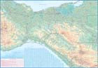
Middle East
Ordinær pris 199,00 kr/
Mva inkludert
Frakt beregnes i kassen.
Middle East at 1:2,000,000 from Freytag & Berndt, with a separate index booklet also providing street plans of central districts of Amman, Cairo, Damascus, Nicosia and Tehran. City names are in their local versions, with English equivalents shows where necessary (Dimashs/Damascus, Bur Said/Port Said, Halab/Aleppo, Al Mawsul/Mosul, etc.).
Topography is shown by relief shading with additional colouring/graphics for salt flats, rock or sand deserts, etc. National boundaries are prominently marked and within most countries internal administrative borders are also shown (without names of the provinces). Road network includes selected local and desert tracks, Driving distances are shown on main routes and border crossings are clearly marked. The map also shows principal railway lines, ferry routes and local airports. Also marked are oil fields and pipelines.
Latitude and longitude lines are drawn at 1° intervals. The index, in a separate booklet attached to the map cover, lists all locations by country. Map legend includes English.
- Publisert: 2024
- Innbinding: Falset
- Materiale: Papir
- Målestokk: 1:2 000 000

Lonely Planet Milan
Ordinær pris 119,00 kr/
Mva inkludert
Frakt beregnes i kassen.
Lonely Planet City Map er slitesterkt og vanntett, med en hendig slipcase og et format som er lett å brette. Få mer ut av kartet og reisen din med bilder og informasjon om byattraksjoner, transportkart, reiseruteforslag, omfattende gate- og nettstedsindeks og praktiske reisetips. Med dette brukervennlige navigasjonsverktøyet i baklommen kan du virkelig komme til hjertet av din destinasjon!
- Publisert: April 2025
- Utgave: 2. utgave
- Innbinding: Falset
- Materiale: Plastpapir
- ISBN: 9781787017191

Montenegro
Ordinær pris 189,00 kr/
Mva inkludert
Frakt beregnes i kassen.
Highly tear-resistant and 100% waterproof map "Montenegro" from the world mapping project series.
Travel Know-How Maps are characterized by particularly stable plastic paper, which can be written on like paper, even with a pencil. The cardboard envelope is removable, making it easy to put the card in any pocket. A protective cover is not required. The cartographic representation focuses on the most important information for travellers and is particularly easy to read. Instead of shading, coloured height layers are used.
- Publisert: 2024
- Innbinding: Falset
- Materiale: Plastpapir
- Målestokk: 1:160 000

Lonely Planet Montreal
Ordinær pris 119,00 kr Salgspris 59,50 kr Spar 50%/
Mva inkludert
Frakt beregnes i kassen.
Lonely Planet City Map er slitesterkt og vanntett, med en hendig slipcase og et format som er lett å brette. Få mer ut av kartet og reisen din med bilder og informasjon om byattraksjoner, transportkart, reiseruteforslag, omfattende gate- og nettstedsindeks og praktiske reisetips. Med dette brukervennlige navigasjonsverktøyet i baklommen kan du virkelig komme til hjertet av din destinasjon!
- Publisert: Sep, 2017
- Utgave: 1.utg
- Innbinding: Falset
- Material: Plast papir

Morocco
Ordinær pris 199,00 kr/
Mva inkludert
Frakt beregnes i kassen.
Morocco at 1:1,000,000 on an indexed road map with topographic and tourist information, printed on light, waterproof and tear-resistant plastic paper. The map, part of Reise Know-How’s highly acclaimed World Mapping Project, is double-sided to provide the best balance between a good scale and a convenient size sheet. The map divides Morocco north/south with a generous overlap between the sides: Marrakesh, the Toubkal Massif and Essaouira are included on both sides. The southern part of Western Sahara is shown as an inset at 1:2,500,000. Names of larger towns are additionally given in Arabic.
Topography is indicated by altitude colouring with spot heights and mountain passes, names of mountain ranges and peaks, seasonal rivers and lakes, salt pans, oases and wells. National parks are highlighted. Road information includes dirt roads and tracks, indicating scenic routes, locations of petrol stations and river fords, plus intermediate driving distances on main routes. Railways and local airfields are also shown. Symbols mark various places of interest: campsites, UNESCO World Heritage sites, forts and religious buildings, archaeological sites, beaches, surfing and fishing locations, viewpoints, etc. The map has a latitude/longitude grid at intervals of 1º and an index of localities. Map legend includes English.
- Publisert: 2025
- Innbinding: Falset
- Materiale: Plastpapir
- Målestokk: 1:1 000 000

Mount Elgon - Map and Guide
Ordinær pris 149,00 kr Salgspris 74,50 kr Spar 50%/
Mva inkludert
Frakt beregnes i kassen.
Kart over Mount Elgon. Kartet ble publisert i 1989, men er fortsatt det mest oppdaterte på området i 2025.
- Publisert: 1989
- Innbinding: Falset
- Materiale: Papir
- Målestokk: 1:500 000

Mount Elikon
Ordinær pris 149,00 kr Salgspris 74,50 kr Spar 50%/
Mva inkludert
Frakt beregnes i kassen.
Publisert år: 2005
Innbinding: falset
Material: plastpapir
Målestokk: 1:50000
Innbinding: falset
Material: plastpapir
Målestokk: 1:50000


Mount Triglav
Ordinær pris 219,00 kr/
Mva inkludert
Frakt beregnes i kassen.
The central part of the Triglav National Park on a light, waterproof and tear-resistant, contoured and GPS compatible map at 1:25,000 from Kartografija, with on the reverse details of local mountain shelters with photos and QR codes. The map is centered on the peak of Triglav and coverage extends north to Kranjska Gora, south to the Bohinj Lake, west to Trenta, and east to Bohinjska Bistrica in the south-eastern corner of the map.
Contours at 10m intervals with shading and graphics relief, plus plenty of spot heights provide and excellent presentation of the topography. An overprint highlights waymarked hiking trails, indicating difficult sections. 32 mountain shelters are cross-referenced to the information on the reverse, with more symbols highlighting locations of other tourist accommodation , inns, climbing sites, viewpoints, interesting natural or cultural sites, etc. Road network shows car parks and petrol stations. The map has latitude and longitude lines at 1’ intervals plus UTM crosshairs at 1km intervals.
On the reverse an overview map highlights eight access routes to the peak of Triglav. 25 shelters are presented with photos, contact details, GPS coordinates and QR codes for further information; also listed are seven more huts highlighted on the map.
- Publisert: 2024
- Innbinding: Falset
- Materiale: Vannfast papir
- Målestokk: 1:25 000

Mount Xixabangma
Ordinær pris 220,00 kr Salgspris 110,00 kr Spar 50%/
Mva inkludert
Frakt beregnes i kassen.
- Innbinding: Falset
- Materiale: Papir
- Målestokk: 1:100.000

Lonely Planet Munich
Ordinær pris 119,00 kr/
Mva inkludert
Frakt beregnes i kassen.
Lonely Planet City Map er slitesterkt og vanntett, med en hendig slipcase og et format som er lett å brette. Få mer ut av kartet og reisen din med bilder og informasjon om byattraksjoner, transportkart, reiseruteforslag, omfattende gate- og nettstedsindeks og praktiske reisetips. Med dette brukervennlige navigasjonsverktøyet i baklommen kan du virkelig komme til hjertet av din destinasjon!
- Publisert: Mai 2024
- Utgave: 2. utgave
- Innbinding: Falset
- Materiale: Plastpapir
- ISBN: 9781787015944

Munich
Ordinær pris 159,00 kr/
Mva inkludert
Frakt beregnes i kassen.
- Publisert: Mars 2025
- Innbinding: Falset
- Materiale: Vannfast papir
- Målestokk: 1:16 000

Myanmar (Burma)
Ordinær pris 189,00 kr/
Mva inkludert
Frakt beregnes i kassen.
Dette store østerriske kartforlaget er kjent for sin klare kartografi og gode papirkvalitet. De kommer i alle målestokker, og flere av landkartene inneholder bykart og turistinformasjon.
Burma (Myanmar) at 1:1,000,000 on a large, double-sided, indexed road map from Freytag & Berndt, with clear presentation of the country’s road network, its topography, various places of interest and its administrative divisions.
The map divides the country north/south, with a good overlap between the sides. Coverage includes the western part of Thailand with Bangkok and Chiang Mai and extends south to Phuket. Relief shading with spot heights shows the country’s topography. National parks and other protected areas are highlighted. Road network includes selected unpaved roads and local tracks; driving distances are indicated on main routes and locations of border crossings are marked. The map shows railway lines and local airports, as well as the country’s internal administrative boundaries with names of the provinces. Also marked are oil fields and pipelines. Small icons clearly highlight various places of interest. The map has latitude and longitude lines at intervals of 1º and an extensive index. Multilingual map legend includes English.
Publisert år: 2018
Innbinding: falset
Material: papir
Målestokk: 1:1200000

Myanmar (Burma)
Ordinær pris 169,00 kr/
Mva inkludert
Frakt beregnes i kassen.
Tysk kartserie med flotte kart på slitesterkt plastpapir.
Myanmar / Burma at 1:1,500,000 on an indexed, waterproof and tear-resistant road map with topographic and tourist information, published by Reise Know-How as part of their highly acclaimed World Mapping Project. The map is double-sided to provide the best balance between a good scale and a convenient size sheet, with a very generous overlap between the two sides. Coverage on the southern side extends east to Bangkok and south to Ko Samui and Surat Thani, indicating border crossings to Thailand.
Road and rail networks are easy to see on a clear base which presents topography by light altitude colouring with contours, spot heights, mountain passes and names of mountain ranges. Road network includes selected local tracks and gives driving distances on main roads. Internal administrative boundaries are shown with names of the provinces. National parks and protected areas are marked and symbols highlight various places of interest, including UNESCO world heritage sites, archaeological remains, temples and museums, viewpoints, beaches, etc. The map also shows old versions of many town names (Sittwe / Akyab, Bago / Pegu, Pyay / Prome, etc. Latitude and longitude lines are at intervals of 1º. Extensive index of localities also includes names of national parks, places of interest, etc. Map legend includes English.
Publisert år: 2017
Innbinding: falset
Material: plastpapir
Målestokk: 1:1500000

Myanmar (Burma)
Ordinær pris 149,00 kr/
Mva inkludert
Frakt beregnes i kassen.
Nelles dekker store deler av kloden og er spesielt gode på den ikke-vestlige verden. Bykart er innsatt i regionskartene, og du får avstandstabeller og avmerkede attraksjoner som for eksempel nasjonalparker.
Publisert år: 2019
Innbinding: falset
Material: Plastpapir
Målestokk: 1:1500000

Mykonos; Delos; Reneia
Ordinær pris 149,00 kr Salgspris 74,50 kr Spar 50%/
Mva inkludert
Frakt beregnes i kassen.
Publisert år: 2015
Innbinding: falset
Material: plastpapir
Målestokk: 1:25000
Innbinding: falset
Material: plastpapir
Målestokk: 1:25000

NAY PYI TAW & YANGON
Ordinær pris 179,00 kr/
Mva inkludert
Frakt beregnes i kassen.
Publisert år: 2013
Innbinding: fal
Material: papir
Målestokk: 1:60000
Innbinding: fal
Material: papir
Målestokk: 1:60000

Lonely Planet New Orleans
Ordinær pris 119,00 kr/
Mva inkludert
Frakt beregnes i kassen.
Lonely Planet City Map er slitesterkt og vanntett, med en hendig slipcase og et format som er lett å brette. Få mer ut av kartet og reisen din med bilder og informasjon om byattraksjoner, transportkart, reiseruteforslag, omfattende gate- og nettstedsindeks og praktiske reisetips. Med dette brukervennlige navigasjonsverktøyet i baklommen kan du virkelig komme til hjertet av din destinasjon!
- Publisert: Aug 2025
- Utgave: 2 utgave
- Innbinding: Falset
- Materiale: Vannfast papir
- ISBN: 9781787015999

Lonely Planet New York City
Ordinær pris 119,00 kr/
Mva inkludert
Frakt beregnes i kassen.
Lonely Planet City Map er slitesterkt og vanntett, med en hendig slipcase og et format som er lett å brette. Få mer ut av kartet og reisen din med bilder og informasjon om byattraksjoner, transportkart, reiseruteforslag, omfattende gate- og nettstedsindeks og praktiske reisetips. Med dette brukervennlige navigasjonsverktøyet i baklommen kan du virkelig komme til hjertet av din destinasjon!
- Publisert: Des. 2023
- Utgave: 2. utgave
- Innbinding: Falset
- Materiale: Vannfast papir
- ISBN: 9781787016026