Filter
- Albania
- Algerie
- Andorra
- Angola
- Argentina
- Armenia
- Aserbajdsjan
- Australia
- Bangladesh
- Belgia
- Belize
- Benin
- Bhutan
- Bolivia
- Bosnia-Hercegovina
- Botswana
- Brasil
- Brunei
- Bulgaria
- Burundi
- Canada
- Chile
- Colombia
- Costa Rica
- Cuba
- Danmark
- Djibouti
- Dominica
- Ecuador
- Egypt
- Ekvatorial-Guinea
- El Salvador
- Eritrea
- Estland
- Eswatini
- Etiopia
- Fiji
- Filippinene
- Finland
- Frankrike
- Gabon
- Gambia
- Georgia
- Guyana
- Hellas
- Honduras
- Hviterussland
- India
- Indonesia
- Irak
- Iran
- Irland
- Island
- Israel
- Italia
- Jamaica
- Japan
- Jemen
- Jordan
- Kambodsja
- Kamerun
- Kapp Verde
- Kasakhstan
- Kenya
- Kina
- Kirgisistan
- Kongo
- Kosovo
- Kroatia
- Kypros
- Laos
- Latvia
- Lesotho
- Libanon
- Libya
- Litauen
- Luxembourg
- Madagaskar
- Malawi
- Malaysia
- Mali
- Malta
- Marokko
- Mauritania
- Mauritius
- Mexico
- Moldova
- Monaco
- Mongolia
- Montenegro
- Mosambik
- Namibia
- Nauru
- Nederland
- Nepal
- New Zealand
- Nicaragua
- Niger
- Nigeria
- Nord-Korea
- Norge
- Oman
- Pakistan
- Palestina
- Panama
- Papua Ny-Guinea
- Paraguay
- Peru
- Polen
- Portugal
- Romania
- Russland
- Rwanda
- Samoa
- San Marino
- Senegal
- Serbia
- Sierra Leone
- Singapore
- Slovakia
- Slovenia
- Solomonøyene
- Somalia
- Spania
- Sri Lanka
- Storbritannia
- Surinam
- Sveits
- Sverige
- Sør-Afrika
- Sør-Korea
- Taiwan
- Tanzania
- Thailand
- Togo
- Tonga
- Tsjekkia
- Tunisia
- Turkmenistan
- Tyrkia
- Tyskland
- Uganda
- Ukraina
- Ungarn
- Uruguay
- USA
- Usbekistan
- Venezuela
- Vietnam
- Zambia
- Zimbabwe
- Østerrike
1828 produkter
1828 produkter


Spain: South Rail & Road
Ordinær pris 179,00 kr/
Mva inkludert
Frakt beregnes i kassen.
The southern half of Spain (and of Portugal, which is also included) consists of the portion from Toledo/Castellon south to the Mediterranean. Side 1 (the cover side) focuses on the eastern portion, from Granada to the coast, including the Balearic islands of Mallorca, Menorca, and Ibiza, and the other side the portion of Spain west of Granada, including that portion of Portugal from north of Lisbon to the Algarve. Gibraltar is included, as are the Straits and the Spanish enclave of Ceuta and part of Tangier. A large inset of the seven Canary Islands is also shown. This map completes our regional mapping of Spain (the other two titles are Spain North and Cataluña/Barcelona).
Spain has invested heavily in its train network, so we note both rapid train and regular train routes, as well as the expanding motorway network. Major touristic sites are noted, as always, with special attention to world heritage sites. The scale is excellent for those wanting to explore this portion of Spain at leisure.
- Publisert: 2022
- Innbinding: Falset
- Materiale: Plastpapir
- Målestokk: 1:700 000

Sri Lanka & India South
Ordinær pris 199,00 kr/
Mva inkludert
Frakt beregnes i kassen.
This edition is a considerable improvement on our previous one, benefitting from the extensive research trip we took to the emerald-shaped island shortly before the outbreak of Covid changed the world. We have re-introduced it as a map printed on waterproof paper, as such a format holds up well in a hot, humid climate. We visited all parts of the island and were quite impressed by the number of local hotels and resorts that we found and have added to the map. We were particularly gratified to discover progress on extending the motorway system for the country, much of it now probably delayed due to Covid.
The inset map of Colombo is particularly well-done. The second side of the sheet is a very detailed map of the southern third of India, from Nagpur to the southern tip of the country. Space constraints did not allow for inset maps, but several well-known cities are included – Mumbai, Hyderabad, Chennai, Pondicherry, Madurai, and Bengaluru (Bangalore) among them. India is a fascinating, if somewhat intimidating, place to visit, but is well-worth the time to do so.
- Publisert: 2021
- Innbinding: Falset
- Materiale: Plastpapir
- Målestokk: 1:450 000 / 1:1 600 000

St. Lucia
Ordinær pris 159,00 kr/
Mva inkludert
Frakt beregnes i kassen.
Gizi map er en serie presise kart med detaljer og opplysninger over både populære og mindre populære reisemål. Dekker ofte områder der få andre kartprodusenter dekker.
Publisert: 2017
Innbinding: falset
Material: papir
Målestokk: 1:50000

St. Martin/St. Maarten & Anguilla
Ordinær pris 169,00 kr/
Mva inkludert
Frakt beregnes i kassen.
ITM har kart over hele verden og de spesialiserer seg på land litt utenfor allfarvei. Beliggenheten til landets nasjonalparker, historiske monumenter, de viktigste veiene o.L. Finner du inkludert i kartene. Samtlige landkart har ofte et bykart over hovedstaden.
Fra ITM: Anguilla is a popular cruise ship destination. This island occupies all of side one, with inset maps of Dog Island, Prickley Pear Cays, and aptly-named Scrub Island. Anguilla enjoys several sandy beaches, only some of which have been developed for resort use, and those ‘resorts’ that do exist tend to be modest operations. The west end Village area seems to have the most beaches, with resorts on Barnes Bay and Maunday’s Bay, but the best beach is a bit further east, at Rendezvous Bay. Crocus Hill, in the centre of the island, contains most of the shopping facilities for the island, and Shoal Bay, on the northern coast has another lovely beach resort area. The other side of the map is devoted to what must be the most unusual aspect of the Caribbean – a relatively small island shared by two European powers, France and Netherlands. The island is Saint Martin (it’s French as well as its English name) or Sint Maarten (its Dutch name). The Dutch occupy the south half of the island, with the cruise ship terminal at Philipsburg, the capital. The town is located along a stretch of beach and is only three streets wide. On the other side of town is Great Salt Pond, so the town has no place in which to expand, so is very congested. Touristic attractions tend to spread out from the town along the south coast. If one rents a car, it is a very enjoyable trip to the north half (the French part) of the island. There is no border, so the only difference is language. Both halves of the island use the Euro as their currency. The northern half has two well-developed beach resort beaches at Orient Bay and at Baie de Grand Case The capital, Marigot, contains most of the shops The highest point of land on the island is Pic Paradis (424m) in the French portion. Inset maps of Philipsburg and Marigot are included. 1st edition 2019. Scales:Anguilla 1:23.000, Saint Martin 1:20.000/Sint Maarten 1:23.000.
Publisert år: 2019
Innbinding: falset
Material: Papir
Målestokk: 1:20,000 / 1:23,000

Stockholm
Ordinær pris 99,00 kr/
Mva inkludert
Frakt beregnes i kassen.
Kart i postkortstørrelse. Folder seg ut som en popoutbok når du åpner dem. Fargerik turistinformasjon med kart over metro og busstraseer, landemerker og lignende. Veldig enkelt å håndtere.
- Publisert: 2025
- Innbinding: Popup
- Materiale: Papp, papir

Stockholm
Ordinær pris 119,00 kr/
Mva inkludert
Frakt beregnes i kassen.
Lonely Planet City Map er slitesterkt og vanntett, med en hendig slipcase og et format som er lett å brette. Få mer ut av kartet og reisen din med bilder og informasjon om byattraksjoner, transportkart, reiseruteforslag, omfattende gate- og nettstedsindeks og praktiske reisetips. Med dette brukervennlige navigasjonsverktøyet i baklommen kan du virkelig komme til hjertet av din destinasjon!
- Publisert: Juli 2025
- Utgave: 2. utgave
- Innbinding: Falset
- Materiale: Vannfast papir
- ISBN: 9781787016613

Stockholm
Ordinær pris 149,00 kr/
Mva inkludert
Frakt beregnes i kassen.
Folded street and travel map in colour. Scale 1:15,000. Legend includes sights, museums, monuments, churches, synagogues, monasteries, castles, windmills, beaches, golf courses, parking, youth hostels, car ferries, airfields, subway, commuter train, camping sites, viewpoints, hotels.
- Publisert: 2023
- Innbinding: Falset
- Materiale: Plastlaminert
- Målestokk: 1:15 000

Street Map: Bruges
Ordinær pris 149,00 kr/
Mva inkludert
Frakt beregnes i kassen.
Discover Bruges by foot, car or bike using Michelin Bruges City Plan (scale 1/12,500 cm). In addition to Michelin's clear and accurate mapping, this city plan will help you explore and navigate across Bruges different districts thanks to its full index, its comprehensive key showing places of interest and tourist attractions, as well as practical information on public transport leisure facilities, service stations and shops!Discover the new range of Michelin City Maps* Write on Wipe off ,Draw your route with a felt tipped pen, Erase with a damp cloth!* Plastic Format* Durable and convenient to use* Handy Compact, folds "free" for easy handling* Clarity and legibility of Michelin mapping:* Map of the city centre with identified tourist sites* Green Guide tourist sites* Smaller Map of whole city* Underground Map, with a detailed index.
Publisert år: 2020
Innbinding: Falset
Material: Plast
Målestokk: 1:12,500

Street Map: Moscow
Ordinær pris 149,00 kr/
Mva inkludert
Frakt beregnes i kassen.
Discover Moscow by foot, car or bike using Michelin Moscow City Plan (scale 1/12,500 cm). In addition to Michelin's clear and accurate mapping, this city plan will help you explore and navigate across Moscow different districts thanks to its full index, its comprehensive key showing places of interest and tourist attractions, as well as practical information on public transport leisure facilities, service stations and shops!Discover the new range of Michelin City Maps* Write on Wipe off, Draw your route with a dry marker tipped pen, Erase with a damp cloth!* Plastic Format* Durable and convenient to use* Handy Compact, folds "free" for easy handling* Clarity and legibility of Michelin mapping:* Map of the city centre with identified tourist sites* Green Guide tourist sites* Smaller Map of whole city* Underground Map, with a detailed index.
Publisert år: 2019
Innbinding: Falset
Material: Plast
Målestokk: 1:12,500

Street Map: St. Petersburg
Ordinær pris 149,00 kr/
Mva inkludert
Frakt beregnes i kassen.
Discover Saint Petersburg by foot, car or bike using Michelin Saint Petersburg City Plan (scale 1/12,500 cm). In addition to Michelin's clear and accurate mapping, this city plan will help you explore and navigate across Saint Petersburg different districts thanks to its full index, its comprehensive key showing places of interest and tourist attractions, as well as practical information on public transport leisure facilities, service stations and shops!Discover the new range of Michelin City Maps* Write on Wipe off ,Draw your route with a felt tipped pen, Erase with a damp cloth!* Plastic Format* Durable and convenient to use* Handy Compact, folds "free" for easy handling* Clarity and legibility of Michelin mapping:* Map of the city centre with identified tourist sites* Green Guide tourist sites* Smaller Map of whole city* Underground Map, with a detailed index.
Publisert år: 2020
Innbinding: Falset
Material: Plast
Målestokk: 1:12,500


Sudan & South Sudan
Ordinær pris 199,00 kr/
Mva inkludert
Frakt beregnes i kassen.
Considering that Sudan is locked into an even more brutal civil war than the one besetting Israel-Hamas, this might seem like an odd time to bring out our first-ever map of Sudan and South Sudan, but it may be an important area of the world to have an updated map of, to focus on a tragedy unfolding mostly unnoticed by the world at large. More than 10,000 locals have been slaughtered since a rebel group made an abortive grasp to overthrow the current government a couple of months ago, mostly in the Darfur region.
ITMB publishes maps to encourage touristic travel, but our maps also bear witness to atrocities and natural disasters and are widely used by selected governments and humanitarian aid groups thanks to the accuracy of our artwork. Side 1 concentrates on Sudan from its disputed (and closed) border with Egypt south to a little below Khartoum, the capital. An inset map of central Khartoum is also included.
Side 2 focusses on South Sudan from its borders with CAR, Congo, Uganda, and Kenya north to the still-contested border with Sudan and the southern provinces of that country. The most dominant feature of both Sudans is the Nile River (White Branch) that flows through both countries on its way to the Mediterranean. This is the first time that South Sudan has been so intensely mapped and is a credit to Lan’s team of cartographers to portray a country carved recently out of adversity and coping with intense tribal rivalries.
- Publisert: 2024
- Innbinding: Falset
- Materiale: Papir
- Målestokk: 1:2 000 000

Surinam & French Guiana
Ordinær pris 149,00 kr/
Mva inkludert
Frakt beregnes i kassen.
ITM har kart over hele verden og de spesialiserer seg på land litt utenfor allfarvei. Beliggenheten til landets nasjonalparker, historiske monumenter, de viktigste veiene o.L. Finner du inkludert i kartene. Samtlige landkart har ofte et bykart over hovedstaden.
Publisert år: 2009
Innbinding: falset
Material: papir
Målestokk: 1:750000

Sverige (Sweden)
Ordinær pris 199,00 kr/
Mva inkludert
Frakt beregnes i kassen.
- Publisert: 2023
- Innbinding: Falset
- Materiale: Papir
- Målestokk: 1:800 000

Sweden
Ordinær pris 189,00 kr/
Mva inkludert
Frakt beregnes i kassen.
Marco Polo er svært detaljerte kart som er praktiske og enkle i bruk. 7 klistremerker for å markere spesifikke steder gjør det enda enklere å planlegge reisen. Alle kartene inneholder en omfattende index for enkelt å finne frem.
- Publisert: 2023
- Innbinding: Falset
- Materiale: Papir
- Målestokk: 1:900 000

Sweden: Central
Ordinær pris 199,00 kr/
Mva inkludert
Frakt beregnes i kassen.
Dette store østerriske kartforlaget er kjent for sin klare kartografi og gode papirkvalitet. De kommer i alle målestokker, og flere av landkartene inneholder bykart og turistinformasjon.
- Publisert: 2024
- Innbinding: Falset
- Materiale: Papir
- Målestokk: 1:250 000

Sweden: South
Ordinær pris 199,00 kr/
Mva inkludert
Frakt beregnes i kassen.
Highly tear-resistant and 100% waterproof map "Sweden, South" from the series world mapping project.
Travel know-how maps are characterized by particularly sturdy plastic paper, which can be written on like paper, even with a pencil. The cardboard envelope is removable, making it easy to put the card in any pocket. A protective cover is not required. The cartographic representation focuses on the most important information for travelers and is particularly easy to read. Instead of shading, colored layers of elevation are used.
- Contour lines with elevation information
- Colored elevation layers
- Classified road network with distance information
- Sights
- Detailed location index
- GPS-accurate
- Longitude and latitude
- Five-language legend (German, English, French, Spanish, Russian)
- Publisert: 2023
- Innbinding: Falset
- Materiale: Plastpapir
- Målestokk: 1:500 000

Sweden: South
Ordinær pris 199,00 kr/
Mva inkludert
Frakt beregnes i kassen.
Dette store østerriske kartforlaget er kjent for sin klare kartografi og gode papirkvalitet. De kommer i alle målestokker, og flere av landkartene inneholder bykart og turistinformasjon.
Kartet dekker området rundt Malmø
- Publisert: 2024
- Innbinding: Falset
- Materiale: Papir
- Målestokk: 1:250 000

Sweden: Southeast
Ordinær pris 199,00 kr/
Mva inkludert
Frakt beregnes i kassen.
Dette store østerriske kartforlaget er kjent for sin klare kartografi og gode papirkvalitet. De kommer i alle målestokker, og flere av landkartene inneholder bykart og turistinformasjon.
Kartet dekker områder rundt Stockholm, Uppsala og Linköping.
- Publisert: 2022
- Innbinding: Falset
- Materiale: Papir
- Målestokk: 1:250 000

Switzerland
Ordinær pris 199,00 kr/
Mva inkludert
Frakt beregnes i kassen.
Perfect touring map - the scale is 1 : 275 000 ideal to help you tour the region by car or campervan. Easy to use - the superbly clear mapping in strong colours and easy to read text will help you navigate the country like a local. Durable, tear-resistant map - designed to withstand the rigors of the road, the map is printed on tear-resistant, water repellent and writeable paper.
- Publisert: 2023-2025
- Innbinding: Falset
- Materiale: Papir
- Målestokk: 1:275 000

Sydney
Ordinær pris 119,00 kr/
Mva inkludert
Frakt beregnes i kassen.
Lonely Planet City Map er slitesterkt og vanntett, med en hendig slipcase og et format som er lett å brette. Få mer ut av kartet og reisen din med bilder og informasjon om byattraksjoner, transportkart, reiseruteforslag, omfattende gate- og nettstedsindeks og praktiske reisetips. Med dette brukervennlige navigasjonsverktøyet i baklommen kan du virkelig komme til hjertet av din destinasjon!
- Publisert: August 2024
- Utgave: 2. utgave
- Innbinding: Falset
- Materiale: Vannfast papir

Sydney
Ordinær pris 99,00 kr/
Mva inkludert
Frakt beregnes i kassen.
Kart i postkortstørrelse. Folder seg ut som en popoutbok når du åpner dem. Fargerik turistinformasjon med kart over metro og busstraseer, landemerker og lignende. Veldig enkel å håndtere.
- Publisert: Oktober 2019
- Innbinding: Popout
- Materiale: Papp, papir
- 5 kart i ett


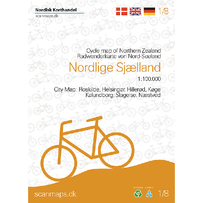
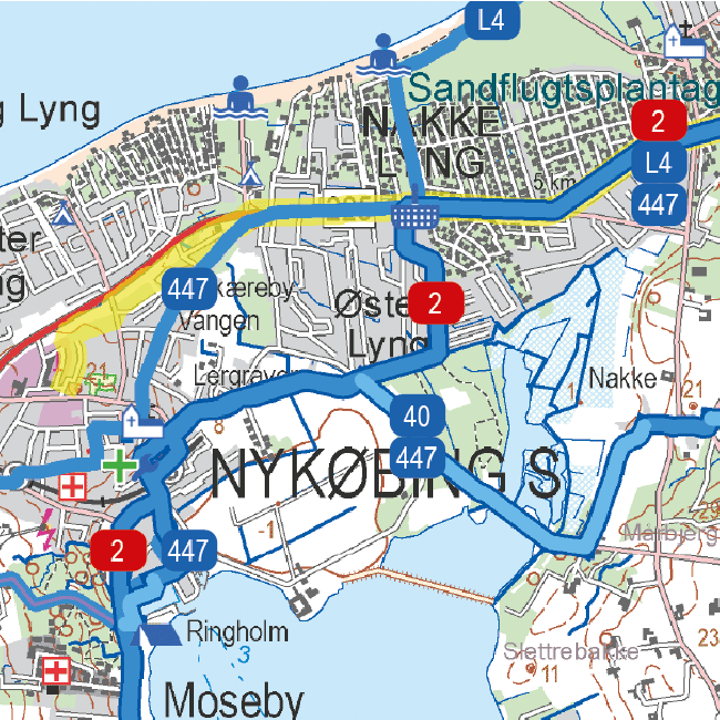
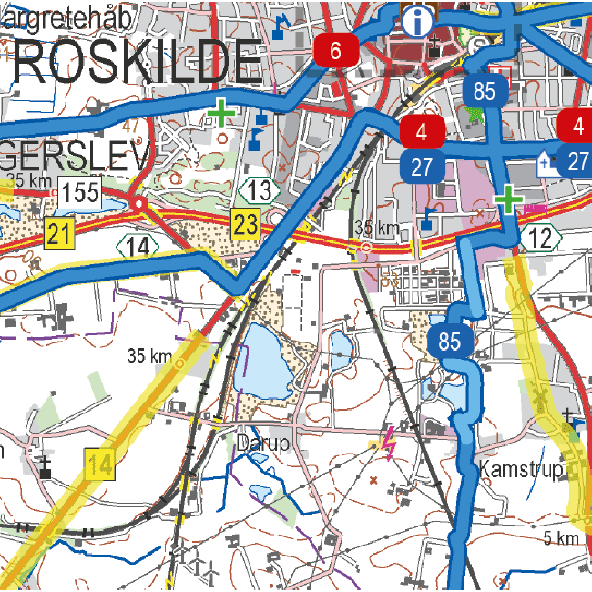
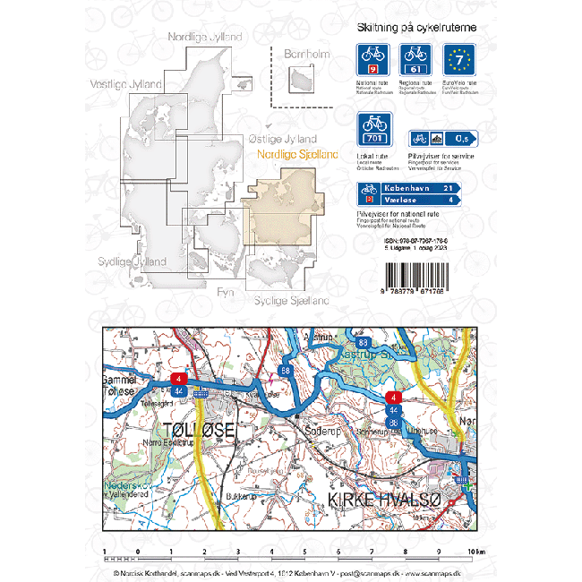
Sykkelkart 1 - Nordlige Sjælland
Ordinær pris 249,00 kr/
Mva inkludert
Frakt beregnes i kassen.
The maps contain: National cycle routes Regional cycle routes Local cycle routes, including the beautiful panorama routes. General information about accommodation, bike inclusion on trains etc. -Information icons on the map: Grocery stores outside major city, Tourist offices, National attractions, UNESCO world heritage, Bicycle friendly churches (special place for bike parking, water bottle filling etc., and a bicycle pump is available), Bike retailers, Beaches, Campsites, Hotels / Inns, Resting places, Hostels, Tent camps Ferry routes List of content is written in Danish, German and English.
- Publisert: 2023
- Innbinding: Falset
- Materiale: Plastpapir
- Målestokk: 1:100 000

Sykkelkart 2 - Sydlige Sjælland
Ordinær pris 249,00 kr/
Mva inkludert
Frakt beregnes i kassen.
- Publisert: 2023
- Innbinding: Falset
- Materiale: Vannfast papir
- Målestokk: 1:100 000

Sykkelkart 3 - Fyn
Ordinær pris 249,00 kr/
Mva inkludert
Frakt beregnes i kassen.
- Publisert: 2022
- Innbinding: Falset
- Materiale: Vannfast papir
- Målestokk: 1:100 000


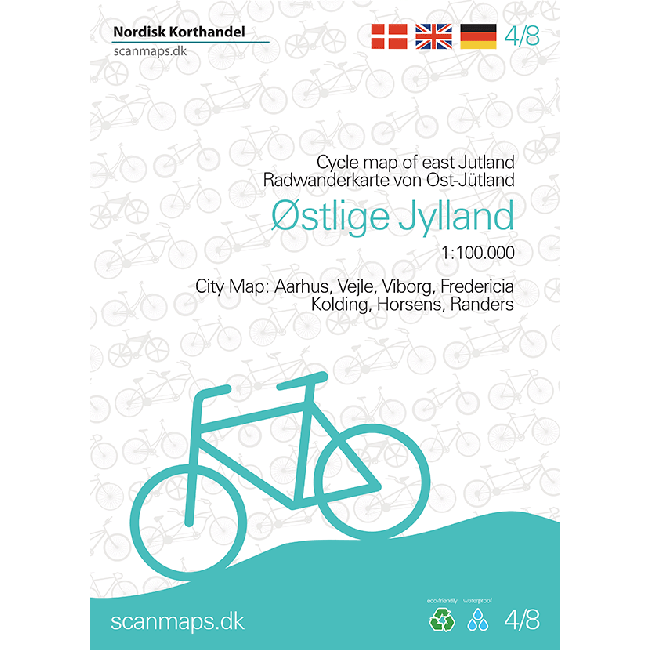
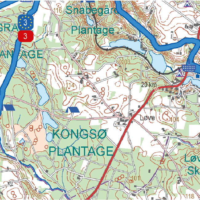
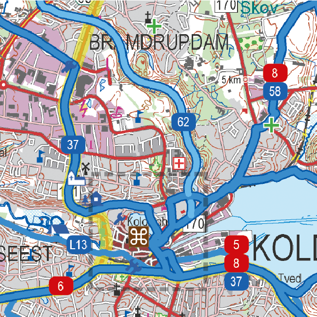
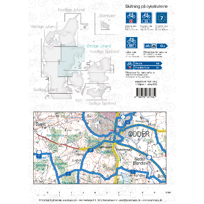
Sykkelkart 4 - Østlige Jylland
Ordinær pris 249,00 kr/
Mva inkludert
Frakt beregnes i kassen.
- Publisert: 2023
- Innbinding: Falset
- Materiale: Plaspapir
- Målestokk: 1:100 000

Sykkelkart 6 - Vestlige Jylland
Ordinær pris 249,00 kr/
Mva inkludert
Frakt beregnes i kassen.
- Publisert: 2022
- Innbinding: Falset
- Målestokk: 1:100 000

Sykkelkart Danmark
Ordinær pris 249,00 kr/
Mva inkludert
Frakt beregnes i kassen.
The map of Denmark in the 4th edition now has bicycle maps on both sides of the map. In addition to the map of Denmark at a scale of 1: 500,000, you also get a bicycle map of Greater Copenhagen at a scale of 1: 35,000.
The map of Denmark contains a lot of information that is indispensable for a cycling holiday in Denmark. The map shows national and regional cycle routes, roads with cycle paths, hostels, campsites, tourist information, etc., and a Eurovelo map of the routes that run through Denmark is drawn. Information about the Danish cycling rules is included. There are over 160 regional and 11 national routes on the map, and new routes include the Culture Ring (East Jutland) and the West Region Route (Copenhagen).
The bicycle map is a planning map that provides an overview of cycling opportunities.
On the other side of the map you have a map of Greater Copenhagen at a scale of 1: 35,000, which is a detailed map of Copenhagen's cycle paths and cycle routes.
- Publisert: 2021
- Materiale: Plastpapir
- Innbinding: Falset
- Målestokk: 1:500 000 (+ København bykart 1:35 000)

Syria & Lebanon
Ordinær pris 199,00 kr/
Mva inkludert
Frakt beregnes i kassen.
Gizi Map er en serie presise kart med detaljer og opplysninger over både populære og mindre populære reisemål. Dekker ofte områder der få andre kartprodusenter dekker.
- Publisert: 2023
- Innbinding: Falset
- Materiale: Papir
- Målestokk: 1:750 000