Filter
- Albania
- Algerie
- Andorra
- Angola
- Argentina
- Armenia
- Aserbajdsjan
- Australia
- Bangladesh
- Belgia
- Belize
- Benin
- Bhutan
- Bolivia
- Bosnia-Hercegovina
- Botswana
- Brasil
- Brunei
- Bulgaria
- Burundi
- Canada
- Chile
- Colombia
- Costa Rica
- Cuba
- Danmark
- Djibouti
- Dominica
- Ecuador
- Egypt
- Ekvatorial-Guinea
- El Salvador
- Eritrea
- Estland
- Eswatini
- Etiopia
- Fiji
- Filippinene
- Finland
- Frankrike
- Gabon
- Gambia
- Georgia
- Guyana
- Hellas
- Honduras
- Hviterussland
- India
- Indonesia
- Irak
- Iran
- Irland
- Island
- Israel
- Italia
- Jamaica
- Japan
- Jemen
- Jordan
- Kambodsja
- Kamerun
- Kapp Verde
- Kasakhstan
- Kenya
- Kina
- Kirgisistan
- Kongo
- Kosovo
- Kroatia
- Kypros
- Laos
- Latvia
- Lesotho
- Libanon
- Libya
- Litauen
- Luxembourg
- Madagaskar
- Malawi
- Malaysia
- Mali
- Malta
- Marokko
- Mauritania
- Mauritius
- Mexico
- Moldova
- Monaco
- Mongolia
- Montenegro
- Mosambik
- Namibia
- Nauru
- Nederland
- Nepal
- New Zealand
- Nicaragua
- Niger
- Nigeria
- Nord-Korea
- Norge
- Oman
- Pakistan
- Palestina
- Panama
- Papua Ny-Guinea
- Paraguay
- Peru
- Polen
- Portugal
- Romania
- Russland
- Rwanda
- Samoa
- San Marino
- Senegal
- Serbia
- Sierra Leone
- Singapore
- Slovakia
- Slovenia
- Solomonøyene
- Somalia
- Spania
- Sri Lanka
- Storbritannia
- Surinam
- Sveits
- Sverige
- Sør-Afrika
- Sør-Korea
- Taiwan
- Tanzania
- Thailand
- Togo
- Tonga
- Tsjekkia
- Tunisia
- Turkmenistan
- Tyrkia
- Tyskland
- Uganda
- Ukraina
- Ungarn
- Uruguay
- USA
- Usbekistan
- Venezuela
- Vietnam
- Zambia
- Zimbabwe
- Østerrike
1828 produkter
1828 produkter

Sykkelkart Danmark
Ordinær pris 249,00 kr/
Mva inkludert
Frakt beregnes i kassen.
The map of Denmark in the 4th edition now has bicycle maps on both sides of the map. In addition to the map of Denmark at a scale of 1: 500,000, you also get a bicycle map of Greater Copenhagen at a scale of 1: 35,000.
The map of Denmark contains a lot of information that is indispensable for a cycling holiday in Denmark. The map shows national and regional cycle routes, roads with cycle paths, hostels, campsites, tourist information, etc., and a Eurovelo map of the routes that run through Denmark is drawn. Information about the Danish cycling rules is included. There are over 160 regional and 11 national routes on the map, and new routes include the Culture Ring (East Jutland) and the West Region Route (Copenhagen).
The bicycle map is a planning map that provides an overview of cycling opportunities.
On the other side of the map you have a map of Greater Copenhagen at a scale of 1: 35,000, which is a detailed map of Copenhagen's cycle paths and cycle routes.
- Publisert: 2021
- Materiale: Plastpapir
- Innbinding: Falset
- Målestokk: 1:500 000 (+ København bykart 1:35 000)

Syria & Lebanon
Ordinær pris 199,00 kr/
Mva inkludert
Frakt beregnes i kassen.
Gizi Map er en serie presise kart med detaljer og opplysninger over både populære og mindre populære reisemål. Dekker ofte områder der få andre kartprodusenter dekker.
- Publisert: 2023
- Innbinding: Falset
- Materiale: Papir
- Målestokk: 1:750 000


Tahiti & French Polynesia
Ordinær pris 199,00 kr/
Mva inkludert
Frakt beregnes i kassen.
Anyone who has visited Tahiti retains fond memories of a wonderful Polynesian paradise. This map shows the major islands of French Polynesia as a series of large insets on Side 1. An overall inset map showing the many islands is also shown, but for showing detail, one must expand the individual islands. The largest one is the volcanic Tahiti Nui, with the capital city of Pape’ete (or Papeete in English), for which a detailed inset map is included. Most visitors stay in the vicinity of Papeete, along the coast. We show several popular resorts. There is a good circular road around the island’s shoreline, but no roads in the interior. The island is joined to another, called Tahiti Iti, or Little Tahiti, and roads extend partway around this less-developed part of the combined island. Most of the other islands are rarely visited, although they have resorts, beaches, and a lifestyle of their own. Names like Huahine, Riatea, Tahaa, and Maiao may not be as familiar as they should be, but all can be reached by inter-island transportation. Moorea and Bora Bora are much better known, with numerous resorts along the coastline. Being a French Overseas Possession, Tahiti uses the Euro as a currency, so expect European prices! Tahiti is also a popular destination stop for cruise ships. The second side of the map covers a part of the world impossible to map well. The region known alternatively as Polynesia and as the South Pacific consists of a vast amount of water, dotted with small islands that are little more than the tips of mountains resting far below the surface. This map shows Hawaii at the upper edge and the northern tip of New Zealand at the bottom. The Queensland coast of Australia is at the far left, and the very isolated Pitcairn Islands at the eastern edge. In between are Cook Islands, Tahiti, Samoa, Fiji, the Solomons, Nauru, Kiribati, Micronesia, and the Marshall Islands. This vast expanse of ocean is becoming increasingly attractive as a cruise ship area, simply because it is the only way most of us could ever visit this region affordably. I like this map because it shows undersea mountain chains and names dozens of islands we’ve probably heard of and dreamed of visiting. Where exactly is Niue, for instance, or Fanning Island? Did you know that the USA has island colonial possessions all over the Pacific? Samoa is well known; how about Palmyra Atoll, Howland Island, the Bakers, or Swains Atoll? Lan has really created an enticing map; one looks at it in detail and starts making travel plans in one’s head!
- Publisert: 2025
- Innbinding: Falset
- Materiale: Vannfast papir
- Målestokk: 1:100 000 / 1:16 000 000

Taiwan
Ordinær pris 169,00 kr/
Mva inkludert
Frakt beregnes i kassen.
Our maps combine state-of-the-art, GPS-compatible cartography (including hypsometric tints and contour lines) with a detailed rendering of road networks and touristic information. They offer the best possible scale, level of detail and readability, be it a map of a small island or half a continent.
The maps feature a detachable paper sleeve so that the maps can be folded easily and fit in every pocket. Although printed on plastic, a special coating makes sure the maps retain a paper-like feel and can even be written on with a pencil.
- Publisert: 2019
- Innbinding: Falset
- Materiale: Plastpapir
- Målestokk: 1:300 000


Taiwan & Taipei
Ordinær pris 199,00 kr/
Mva inkludert
Frakt beregnes i kassen.
Taiwan always reminds me of the “little engine that could”. Despite having to endure an extremely hostile neighbour, the country has prospered, is democratic, and is friendly and welcoming to visitors, despite the fact that most governments do not officially recognize its existence. Side 1 shows the capital city of Taipei, a bustling economic powerhouse on the Damshui River, close to the ocean. The city has numerous hotels and shopping areas, and a well-developed subway network.
The second side covers the complete island of Formosa from top to bottom in excellent detail, as well as the off-shore Penghu islands (these can be reached by ferries from Kaohsung or Dongshih). Most of the country’s development is on the western, or Taiwan Straits, side of the mountainous country, but to me the Taroka Gorge, leading inland from Hualien on the east coast, is one of the wonders of modern Asia. An inset map of Tainan in southeast Taiwan is also included.
- Publisert: 2024
- Innbinding: Falset
- Materiale: Vannfast papir
- Målestokk: 1:386 000, 1:16 000

Tenerife
Ordinær pris 379,00 kr/
Mva inkludert
Frakt beregnes i kassen.
- Publisert: 2024
- Innbinding: Falset
- Materiale: Papir
- Målestokk: 1:25 000

Tenerife Hiker's Map
Ordinær pris 229,00 kr/
Mva inkludert
Frakt beregnes i kassen.
Vandrekart for Tenerife.
- Publisert: Januar 2019
- Innbinding: Falset
- Materiale: Plastpapir
- Målestokk: 1:30 000

Thailand
Ordinær pris 199,00 kr/
Mva inkludert
Frakt beregnes i kassen.
Thailand at 1:900,000 on a large, double-sided, indexed road map from Freytag & Berndt, with clear presentation of the country’s road network, its topography, various places of interest and its administrative divisions.
The map divides the country north/south, with a good overlap between the sides. Colouring and relief shading with spot heights show the country’s topography. National parks and other protected areas are clearly highlighted. Road network includes selected unpaved roads and local tracks, with driving distances indicated on main routes. The map also shows railway lines, ferry connections and local airports, as well as the country’s internal administrative boundaries with names of the provinces.
Various places of interest at highlighted by symbols with their names given in English, e.g. ancient or historic city, floating market, historic park, etc. The map has latitude and longitude lines at intervals of 1º and an extensive index. Map legend includes English.
- Publisert: 2024
- Innbinding: Falset
- Materiale: Papir
- Målestokk: 1:900 000

Thailand
Ordinær pris 199,00 kr/
Mva inkludert
Frakt beregnes i kassen.
Highly tear-resistant and 100% waterproof map "Thailand" from the world mapping project series.
Travel Know-How Maps are characterized by particularly stable plastic paper, which can be written on like paper, even with a pencil. The cardboard envelope is removable, making it easy to put the card in any pocket. A protective cover is not required. The cartographic representation focuses on the most important information for travelers and is particularly easy to read. Instead of shading, coloured height layers are used.
- Contour lines with elevations
- Coloured elevation layers
- Classified road network with distances
- Sights
- Detailed place index
- GPS-accurate
- Longitude and latitude
- Five-language legend (German, English, French, Spanish, Russian)
- Publisert: 2024
- Innbinding: Falset
- Materiale: Plastpapir
- Målestokk: 1:1 200 000

Thailand
Ordinær pris 119,00 kr/
Mva inkludert
Frakt beregnes i kassen.
Lonely Planet Planning Map er slitesterkt og vanntett, med en hendig slipcase og et format som er enkelt å brette. Få mer ut av kartet og reisen din med bilder og informasjon om toppattraksjoner i landet, reiseruteforslag, en transportguide, planleggingsinformasjon, temalister og praktiske reisetips. Med dette brukervennlige navigasjonsverktøyet i baklommen kan du virkelig komme til hjertet av din destinasjon!
- Publisert: Mars 2024
- Utgave: 2. utgave
- Innbinding: Falset
- Materiale: Vannfast papir

Thailand; Vietnam - Myanmar; Laos; Cambodia
Ordinær pris 189,00 kr/
Mva inkludert
Frakt beregnes i kassen.
The countries of South-East Asia: Thailand, Vietnam, Cambodia, Laos, Myanmar/Burma, Peninsular Malaysia and Singapore on a map at 1:2,500,000 from Marco Polo Publishing with an index which includes geographical features, three city maps, descriptions of 15 best sights, etc. Coverage extends west to Dhaka to include eastern Bangladesh and the north-eastern states of India.
Cartography is from the renowned German publishers MairDumont. Relief shading with names of mountain ranges and spot heights, plus graphics for marshlands shows the topography. The map presents the regions' road and rail networks, also indicating local airports and ferry connections. Internal administrative boundaries are shown with names of the provinces and the map also indicates time zone boundaries. Interesting towns or villages and main cultural sights or natural curiosities are prominently highlighted, with 15 best sights cross-referenced to their descriptions in the booklet attached to the map cover. The map has latitude and longitude lines at intervals of 1°. Multilingual map legend and the descriptions include English.
Extensive index is in a separate 47-page booklet attached to the map cover and includes major sights and topographic features such as rivers, lakes, volcanoes, glaciers, etc; also provided are lists of national parks and World Heritage sites across the whole are of the map. Street plans show central Bangkok, Phnom Penh and Singapore.
- Publisert: 2023
- Innbinding: Falset
- Materiale: Papir
- Målestokk: 1:2 500 000

The Pyrenees
Ordinær pris 199,00 kr/
Mva inkludert
Frakt beregnes i kassen.
Pyrenees at 1:250,000 on a light waterproof and tear-resistant, indexed road map from Reise Know-How. The map, part of the publishers’ highly acclaimed World Mapping Project, is double-sided to provide the best balance between a good scale and a convenient size sheet, covering the Pyrenees.
The region’s topography is well presented by light altitude colouring with spot heights. Boundaries of national and regional parks are marked. Road network includes local roads and selected country tracks, with driving distances marked on main and on secondary routes. Railway lines are included and ferry connections to the islands are shown. A range of symbols highlight numerous places of interest, including UNESCO World Heritage sites, historical buildings and archaeological remains, recreational facilities, etc. The map is indexed and has latitude and longitude lines at intervals of 15’, plus a UTM grid. Map legend includes English.
- Publisert: 2023
- Innbinding: falset
- Materiale: Plastpapir
- Målestokk: 1:250 000


The Pyrenees & Andorra
Ordinær pris 199,00 kr/
Mva inkludert
Frakt beregnes i kassen.
Road map Pyrenees and Andorra.
The Pyrenees mountain chain straddling the border between France and Spain on one side, with historic Andorra on other side. As is normal with ITMB maps combining two areas at different scales, the map has two covers, so can be marketed equally well as Andorra or as Pyrenees. Our coverage of Pyrenees goes from the Atlantic to the Mediterranean coastlines Legend includes: roads by classification, international airports, domestic airports, ports, ruins, historic/archeological, hot springs, forts, lighthouses, national parks, world heritages, mountain peaks, spot heights, universities, oil fields, point of interests, beaches, camping sites, churches, viewpoints, mosques, passes, caves, border crossings, mines, hospitals and much more.
Detailed travel map of Andorra shows roads from national highways to unpaved tracks; pedestrian paths and trails; railways; attractions; summits with altitude in meters; settlements; isolated buildings; sports fields; swimming pools; parking; hospitals; scenic vistas; Alpine huts; refuges; mountaineering, climbing, and absailing (cliff descent); Grand Randonee hiking trail; skiing; mountain biking; kayaking; camping; hotels; museums; interesting buildings; tourist information; more. Colour changes show elevations. Index of places. Printed on one side. With city map of Andorra la Vella. Main map scale 1:40,000.
- Publisert: 2024
- Innbinding: Falset
- Materiale: Papir
- Målestokk: 1:40 000, 1:500 000

The World
Ordinær pris 119,00 kr/
Mva inkludert
Frakt beregnes i kassen.
Lonely Planet Planning Map er slitesterkt og vanntett, med en hendig slipcase og et format som er enkelt å brette. Få mer ut av kartet og reisen din med bilder og informasjon om toppattraksjoner i landet, reiseruteforslag, en transportguide, planleggingsinformasjon, temalister og praktiske reisetips. Med dette brukervennlige navigasjonsverktøyet i baklommen kan du virkelig komme til hjertet av din destinasjon!
- Publisert: Oktober 2017
- Utgave: 1. utgave
- Innbinding: Falset
- Materiale: Plastpapir

The World
Ordinær pris 199,00 kr/
Mva inkludert
Frakt beregnes i kassen.
Plan your trip, do your school project, use it for quick reference, this highly durable overview map folds away easily and is always on standby to help when you're stuck. Easy to use - the super clear mapping in strong colours and clear text will help you guide you around the world. Flags and country information - learn extra information which this quick reference tool. Overview of world languages - you can quickly see what the local language is for each country. Time Zone Map and Distance table - helps you see which time zone a country is in and the distance between each country. Extensive index - the thorough index is fully cross-referenced to the map to help you pinpoint your destination quickly. For the big trips, the geography projects and the business meetings, trust Marco Polo's clear mapping and thorough index to guide you round the world.
*(1: 30 000 000 / 1cm=300km / 1inch=473 miles)
Publisert: 2025
Innbinding: falset
Material: papir
Målestokk: 1:30,000,000

Three Passes - Everest/Gokyo
Ordinær pris 299,00 kr/
Mva inkludert
Frakt beregnes i kassen.
1:50,000 scale map printed on waterproof, durable material. This beautiful, folded map, is the perfect reference map, guidebook, and planner aid to anyone attempting this long, difficult trekking adventure.
Features three passes;
Kongma La
Chola Pass
Renjola Pass
- Publisert: 2018
- Innbinding: Falset
- Materiale: Papir
- Målestokk: 1:50 000


Togo & Benin
Ordinær pris 169,00 kr/
Mva inkludert
Frakt beregnes i kassen.
ITM har kart over hele verden og de spesialiserer seg på land litt utenfor allfarvei. Beliggenheten til landets nasjonalparker, historiske monumenter, de viktigste veiene og lignende finner du inkludert i kartene. Samtlige landkart har ofte et bykart over hovedstaden.
Fra ITM: The two small countries squeezed between Ghana on the west and Nigeria on the east developed out of the European colonialization of most of Africa Germany, under Kaiser Bill, was determined to create an empire to rival that of Britain, and seized a portion of the coastline close to the British-held area of Ghana and held on to it until WW1 ended Germany’s colonial aspirations. Britain and France jointly governed Togo briefly, but the territory was ceded to France until independence was granted in the 1960s. Neighbouring Benin (formerly the French colony of Dahomey) was all that the French colonial office could obtain of the rich coastal plain until the German defeat in WW1, which gained it Togo and German Cameroun, further to the east. Both countries have their points of interest, but to this day have little to do with each other. There is one border crossing on the coast, and a couple of others much farther inland, but each country operates on a north-south basis, not an east-west one. The map includes inset maps of Lome, the capital of Togo, and Porto Novo, in Benin, which is now the capital. Togo’s best sites are noted in a red inset box, with a separate box for Benin.
- Publisert: 2019
- Innbinding: Falset
- Materiale: Papir
- Målestokk: 1:530 000

Torino
Ordinær pris 169,00 kr/
Mva inkludert
Frakt beregnes i kassen.
- Publisert: 2024
- Innbinding: Falset
- Materiale: Papir
- Målestokk: 1:15 000


Triglav National Park
Ordinær pris 219,00 kr/
Mva inkludert
Frakt beregnes i kassen.
Triglav National Park at 1:50,000 on a contoured and GPS compatible walking and cycling map from Kartografija in Ljubljana, waterproof and tear-resistant version, with on the reverse descriptions of the area’s best sights. Coverage extends from Bovec in the west to Bled in the east, and from Kranjska Gora in the north to just short of Tolmin in the south. On the reverse are bilingual descriptions of the region’s places of interest, including special notes on the World War I Isonzo Front, plus list of mountain huts and campsites with contact details.
Maps in this series have contours at 20m intervals, enhanced by relief shading, with plenty of spot heights and names of peaks, mountain chains, etc. Local hiking routes are highlighted, indicating difficult passages. Also marked are recommended cycling routes. Symbols indicate various types of accommodation including mountain huts, campsites, inns with lodgings, tourist farms or apartments, hotels and motels, as well as recreational facilities (golf, horse riding, swimming pools, etc), vineries, cultural and historical sites, etc. Road network indicates locations of petrol stations. Railway lines are shown with stations and various types of mountain transport (gondolas, chair lifts, etc) are marked. The maps have a latitude and longitude grid at intervals of 2’’.
- Publisert: 2024
- Innbinding: Falset
- Materiale: Vannfast papir
- Målestokk: 1:50 000

Tsum Valley
Ordinær pris 199,00 kr/
Mva inkludert
Frakt beregnes i kassen.
Tsum Valley in central Nepal on an indexed contoured map at 1:100,000 from Shangri-La Design highlighting local trekking routes and places of interest, etc. Coverage extends roughly from the Budhi Gandaki River in the west across the eastern part of the Manaslu Conservation area, to just beyond Dunche in the east.
Topography is shown by contours at 40m intervals, plus colouring for woodlands, cultivated areas, glaciers, etc. The map shows local roads and distinguished between main trekking routes and minor trails. An overprint indicates various facilities in local villages, campsites, monasteries and other religious buildings, etc. The map is indexed for places, peaks and passes and had latitude and longitude margin ticks at 5’ intervals. Map legend includes English.
Addition information provided on the map or on its cover includes a table with relative oxygen rates at different altitudes, elevation profiles and hiking times for three main routes, plus general information about the area. All the text is in English.
Publisert år: 2009
Innbinding: falset
Material: papir
Målestokk: 1:100.000


Tunisia
Ordinær pris 239,00 kr/
Mva inkludert
Frakt beregnes i kassen.
Tysk kartserie med flotte kart på slitesterkt, vannfast plastpapir.
- Publisert: 2024
- Innbinding: Falset
- Materiale: Vannfast papir
- Målestokk: 1:600 000


Turistkart Danmark og Storkøbenhavn og Margueriteruten
Ordinær pris 269,00 kr/
Mva inkludert
Frakt beregnes i kassen.
- Publisert: 2025
- Innbinding: Falset
- Målestokk: 1:500 000 (+ københaven kart: 1:35 000)
- ISBN: 9788779671836

Türkiye
Ordinær pris 199,00 kr/
Mva inkludert
Frakt beregnes i kassen.
The ideal map for your trip. Let the Marco Polo Turkiye Road Map guide you around this stunning country. From the Turquoise Riviera to the Fairy Chimneys of Cappadocia, this highly durable, detailed, touring map of Turkiye will ensure you don't miss a thing. It folds away easily and is always on standby to help when you're stuck.
- Publisert: Juni 2025
- Innbinding: Falset
- Materiale: Papir
- Målestokk: 1:1,000,000

Türkiye (Turkey)
Ordinær pris 199,00 kr/
Mva inkludert
Frakt beregnes i kassen.
Turkey at 1:1,100,000 on a waterproof and tear-resistant road map with topographic and tourist information, published by Reise Know-How as part of their highly acclaimed World Mapping Project. The map is double-sided to provide the best balance between a good scale and a convenient size sheet, with a good overlap between the two sides.
Road and rail networks are easy to see on a clear base which presents topography by altitude colouring with contours, spot heights, mountain passes, names of mountain ranges, and graphics for marshland. National parks are marked. Road network includes local roads and selected tracks, and shows driving distances on main routes. Scenic roads are highlighted. Symbols indicate various places of interest, including campsites, UNESCO World Heritage sites, archaeological remains, viewpoints, spas, beaches, etc. The map has a latitude and longitude grid at intervals of 1° and an extensive index of localities. Map legend includes English.
- Publisert: 2023
- Innbinding: Falset
- Materiale: Plastpapir
- Målestokk: 1:1 100 000

Turkmenistan
Ordinær pris 249,00 kr/
Mva inkludert
Frakt beregnes i kassen.
Gizi Map er en serie presise kart med detaljer og opplysninger over både populære og mindre populære reisemål. Dekker ofte områder der få andre kartprodusenter dekker.
- Publisert: 2019
- Innbinding: Falset
- Materiale: Papir
- Målestokk: 1:1 300 000


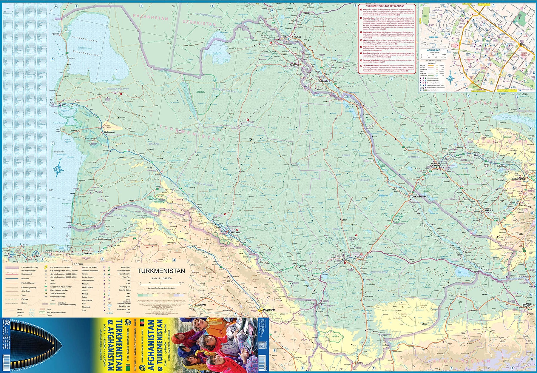
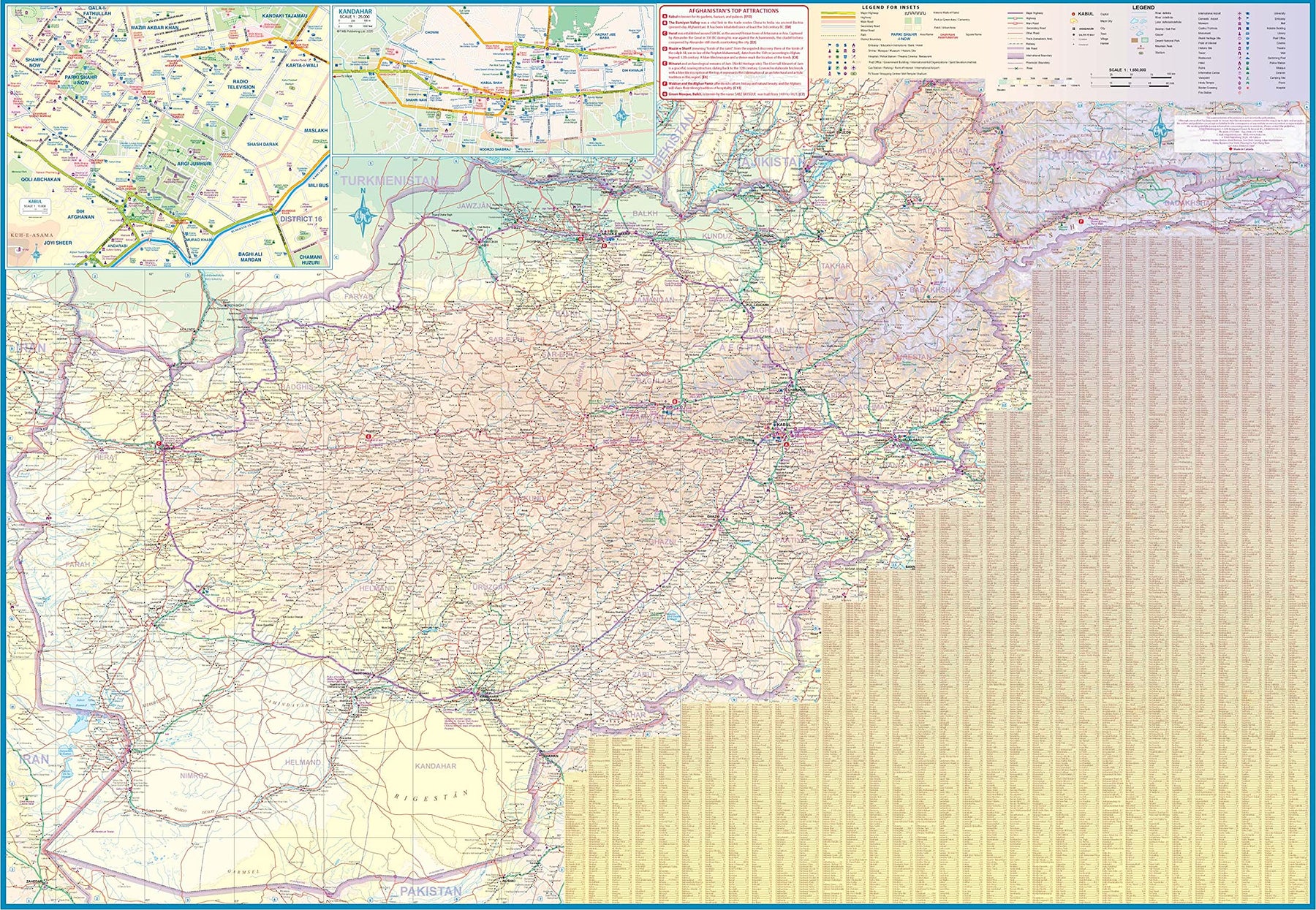
Turkmenistan & Afghanistan
Ordinær pris 179,00 kr/
Mva inkludert
Frakt beregnes i kassen.
The world is changing as a result of a global pandemic, and ITMB has to change with it. We wish to keep all of our artwork available, but at a time of greatly reduced travel, we have been forced to combine two different countries that share a common border in order to justify printing either one. The two countries, Afghanistan and Turkmenistan, do share a common heritage, but a very different history. ITMB Publishes a separate map of the country, and a map of Kabul. The reason for this map is that it is our first ever map of just Turkmenistan, a former part of the USSR that broke away in the collapse of the Russian empire in 1990. The country has, however, not emerged from the Soviet way of thinking, and is authoritarian in its attitude. It is, fortunately, open to travel, and is slowly improving its facilities, so is to be encouraged.
The map includes a very good inset map of Ashgabat, the capital. The country stretches from the Caspian Sea to the Uzbek border and from Russia south to Iran and Afghanistan. We have also added eight Top Attractions, ranging from the World Heritage site of Konye to the ancient ruins of Nisa. We previously published this titles as part of a regional map of the ‘Stans’, but growing demand has justified its own map. We have also published a separate map of Uzbekistan and a separate three-country map of the other three countries, all of which are showing strong signs of touristic development. Turkmenistan is a country emerging as a future travel Mecca. Legend Includes: Roads by classification, Rivers and Lakes, National Park, Airports, Points of Interests, Highways, Main Roads, Zoos, Fishing, and much more...
- Publisert: Aug. 2021
- Innbinding: Falset
- Materiale: Vanntett papir
- Målestokk: 1:1 350 000, 1:650 000