1151 produkter
Nicaragua & El Salvador
Ordinær pris 149,00 krITM har kart over hele verden og de spesialiserer seg på land litt utenfor allfarvei. Beliggenheten til landets nasjonalparker, historiske monumenter, de viktigste veiene o.L. Finner du inkludert i kartene. Samtlige landkart har ofte et bykart over hovedstaden.
Publisert år: 2015
Innbinding: falset
Material: plastpapir
Målestokk: 1:700000
Nicaragua & Honduras
Ordinær pris 169,00 krITM har kart over hele verden og de spesialiserer seg på land litt utenfor allfarvei. Beliggenheten til landets nasjonalparker, historiske monumenter, de viktigste veiene o.L. Finner du inkludert i kartene. Samtlige landkart har ofte et bykart over hovedstaden.
Fra ITM: Central America generally remians poplar with visitors. Both Honduras and Nicaragua, which occupy different sides of this sheet, have a lot of attractions to offer. Honduras offers beaches, the wonderful Mayan complex of Copan, lake Yojoa, the colonial heritage of Belen Gualcho, the Valley of Angels, and a city of charm named Gracias A large inset map of Tegucigalpa, the capital, is included. Nicaragua has one of the oldes urban areas in the Western Hemisphere, Granada (1534), the mountains of Matagalpa, quiet fishing villages, pottery works at San Juan, the largest lake in Central America, and touristic islands off the coast. An excellent inset map of Managua, the capital, is included.
Publisert år: 2019
Innbinding: falset
Material: papir
Målestokk: 1:700000
Nigeria & Niger
Ordinær pris 149,00 krITM har kart over hele verden og de spesialiserer seg på land litt utenfor allfarvei. Beliggenheten til landets nasjonalparker, historiske monumenter, de viktigste veiene og lignende finner du inkludert i kartene. Samtlige landkart har ofte et bykart over hovedstaden.
4th edition November 2018. Nigeria in 1:1.600.000 and Niger in 1:2.000.000. Inset maps of Lagos Island, Lagos Region, Benin City, Abuja & Niamey.
Nizke Tatry - Chopok
Ordinær pris 149,00 kr Salgspris 99,00 kr Spar 34%Nizke Tatry - Kralova Hola
Ordinær pris 149,00 kr Salgspris 99,00 kr Spar 34%NOIJINKANGSANG
Ordinær pris 219,00 kr Salgspris 109,50 kr Spar 50%Nordaustlandet
Ordinær pris 169,00 krNordmarka sør - løypekart
Ordinær pris 259,00 krLøypekart Nordmarka sør er ett av fire spesialkart i målestokk 1:20 000 som dekker Oslomarka. Kartet er utarbeidet i tett samarbeid med Skiforeningen. Kartserien er skreddersydd for vinterbruk og dekker mer enn 3 000 kilometer med preparerte skiløyper.
Hvert kart viser tydelig løypetyper og avstandsinformasjon, samt nyttige tillegg som parkeringsplasser, hytter og serveringssteder. Informasjonen er tilrette-lagt for enkel koordinering med sanntidsinformasjon på Skiforeningens nettside. Kartene er basert på terrengdata fra laserskanning fra fly, noe som sikrer enestående nøyaktighet i detaljene.
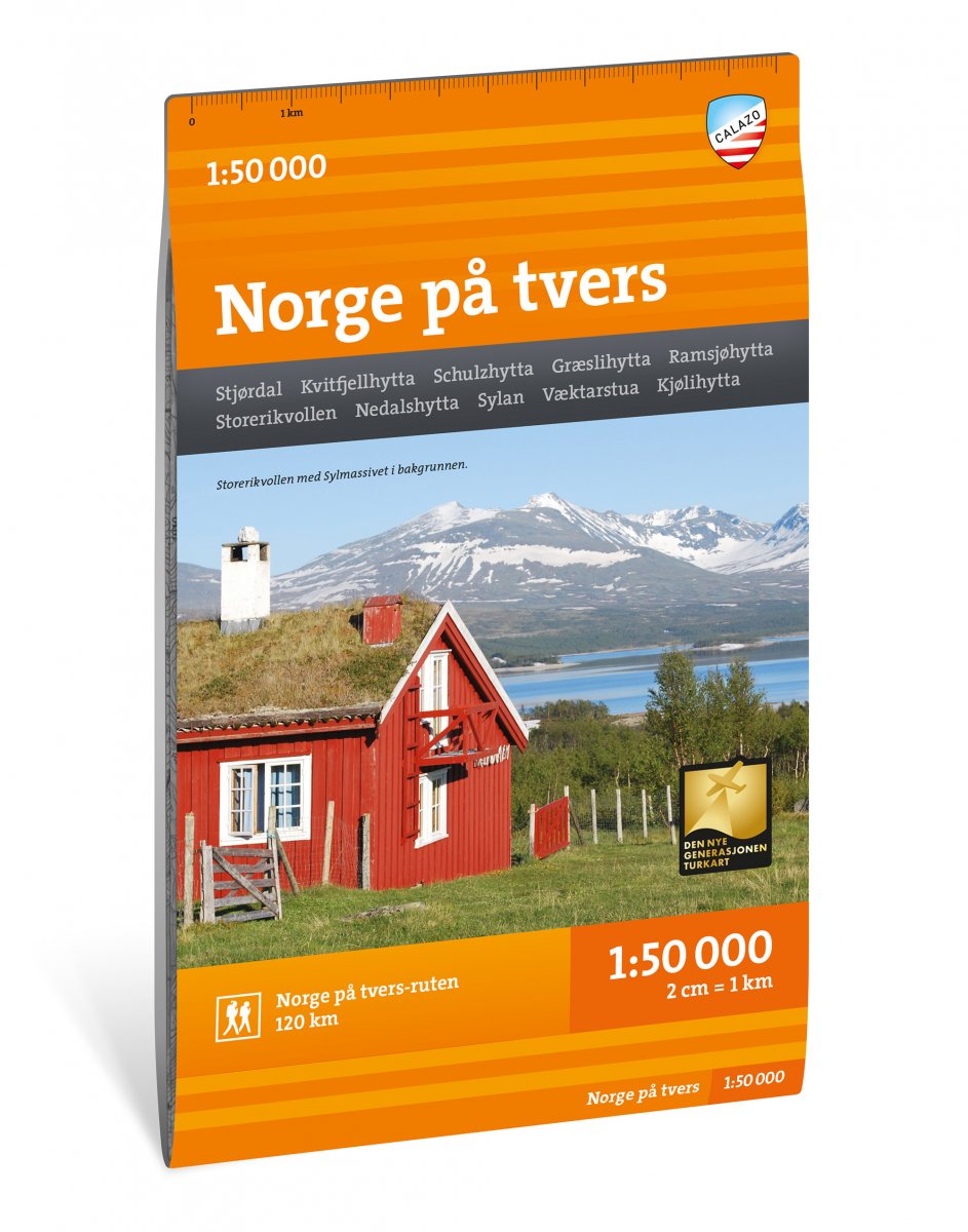
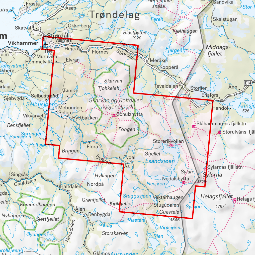
Norge på tvers
Ordinær pris 225,00 krNorge på tvers er en unik ekspedisjonsopplevelse på 120 kilometer, fordelt på 7 dagsetapper gjennom fjellområdet Sylan. Turen følger turistforeningens merkede ruter langs 63 grader nord med overnatting på betjente og selvbetjente DNT-hytter. Dette kartbladet dekker hele strekningen fra fjorden i Stjørdal til svenskegrensen i Tydal med kart på både for- og baksiden. En av godbitene på turen er det mektige Sylmassivet lengst øst i Trøndelag. Den høyeste toppen, Storsylen (1762 moh.), ligger så vidt på norsk side av svenskegrensa.
Norge på tvers-kartet er utgitt av Calazo i samarbeid med Trondhjems Turistforening og Nord-Trøndelag Turistforening. Dette er en del av en moderne kartserie der terrenginformasjonen er basert på laserskanning fra fly. Kartet er laget i materialet Tyvek, som tåler vann, er beskyttet mot rifter og har lav vekt.
Dapa Maps - Norlandia 1750 Helgeland
Ordinær pris 1.200,00 krHøsten 2025 fikk Dapa Maps gleden av å restaurere dette unike historiske kartet - nå klart til å henge på veggen!
Kartet bar preg av tidens tann, med smuss, misfarging og slitasje i brettene. Etter nøye restaurering har detaljene kommet frem igjen - klare, tydelige og vakre.
Om kartet
Norlandia Norlandia er et håndtegnet sjøkart som viser norskekysten fra Namdalen i Trøndelag og nordover til Troms, inkludert Helgeland, Salten, Lofoten, Vesterålen og Senja. Det ble sannsynligvis tegnet rundt 1750, med Andreas Heitmanns oppmålinger fra 1744–45 som forlegg.
Kartet begynner fra Namdalen (Pars Nummedaliæ) i sør, og viser Helgeland, Salten, Lofoten, Vesterålen, Senja og Troms frem til Finnmarken (Pars Finmarchiæ) i nord. I tillegg vises deler av Sverige (Regni Sveciæ Pars) og Svensk Lappland (Lapponia Svecica) i øst og «Nordhavet» (Oceanus septentrionalis) i vest.
Spennende detaljer å se mer på:
Kartet ble første gang omtalt i en auksjonskatalog i 1791, og kom i 1853 til Nasjonalbiblioteket som del av den Werlauffske gave - en samling på 32 håndtegnede kart overført fra Det Kongelige Bibliotek i København.
Dapa Maps
Kartet er laget av Daniel og Pavel fra Dapa Maps. De er to kartografer som tror at livet er best ute, derfor er de opptatt av å lage de peneste kartene de kan for at du kan bli kjent med områdene du liker best. Om du ønsker kan du lese mer om de her.
For hvert kart som selges planter de et tre slik at verden blir litt grønnere 🌳
Ramme
Dapa Maps har endelig funnet frem til den perfekte rammen og kan nå tilby ramme til kartet.
Dapa Maps - Norlandia 1750 Lofoten, Vesterålen og Salten
Ordinær pris 1.200,00 krHøsten 2025 fikk Dapa Maps gleden av å restaurere dette unike historiske kartet - nå klart til å henge på veggen!
Kartet bar preg av tidens tann, med smuss, misfarging og slitasje i brettene. Etter nøye restaurering har detaljene kommet frem igjen - klare, tydelige og vakre.
Om kartet
Norlandia Norlandia er et håndtegnet sjøkart som viser norskekysten fra Namdalen i Trøndelag og nordover til Troms, inkludert Helgeland, Salten, Lofoten, Vesterålen og Senja. Det ble sannsynligvis tegnet rundt 1750, med Andreas Heitmanns oppmålinger fra 1744–45 som forlegg.
Kartet begynner fra Namdalen (Pars Nummedaliæ) i sør, og viser Helgeland, Salten, Lofoten, Vesterålen, Senja og Troms frem til Finnmarken (Pars Finmarchiæ) i nord. I tillegg vises deler av Sverige (Regni Sveciæ Pars) og Svensk Lappland (Lapponia Svecica) i øst og «Nordhavet» (Oceanus septentrionalis) i vest.
Spennende detaljer å se mer på:
Kartet ble første gang omtalt i en auksjonskatalog i 1791, og kom i 1853 til Nasjonalbiblioteket som del av den Werlauffske gave - en samling på 32 håndtegnede kart overført fra Det Kongelige Bibliotek i København.
Dapa Maps
Kartet er laget av Daniel og Pavel fra Dapa Maps. De er to kartografer som tror at livet er best ute, derfor er de opptatt av å lage de peneste kartene de kan for at du kan bli kjent med områdene du liker best. Om du ønsker kan du lese mer om de her.
For hvert kart som selges planter de et tre slik at verden blir litt grønnere 🌳
Ramme
Dapa Maps har endelig funnet frem til den perfekte rammen og kan nå tilby ramme til kartet.
Dapa Maps - Norlandia 1750 Troms og Senja
Ordinær pris 1.200,00 krHøsten 2025 fikk Dapa Maps gleden av å restaurere dette unike historiske kartet - nå klart til å henge på veggen!
Kartet bar preg av tidens tann, med smuss, misfarging og slitasje i brettene. Etter nøye restaurering har detaljene kommet frem igjen - klare, tydelige og vakre.
Om kartet
Norlandia Norlandia er et håndtegnet sjøkart som viser norskekysten fra Namdalen i Trøndelag og nordover til Troms, inkludert Helgeland, Salten, Lofoten, Vesterålen og Senja. Det ble sannsynligvis tegnet rundt 1750, med Andreas Heitmanns oppmålinger fra 1744–45 som forlegg.
Kartet begynner fra Namdalen (Pars Nummedaliæ) i sør, og viser Helgeland, Salten, Lofoten, Vesterålen, Senja og Troms frem til Finnmarken (Pars Finmarchiæ) i nord. I tillegg vises deler av Sverige (Regni Sveciæ Pars) og Svensk Lappland (Lapponia Svecica) i øst og «Nordhavet» (Oceanus septentrionalis) i vest.
Spennende detaljer å se mer på:
Kartet ble første gang omtalt i en auksjonskatalog i 1791, og kom i 1853 til Nasjonalbiblioteket som del av den Werlauffske gave - en samling på 32 håndtegnede kart overført fra Det Kongelige Bibliotek i København.
Dapa Maps
Kartet er laget av Daniel og Pavel fra Dapa Maps. De er to kartografer som tror at livet er best ute, derfor er de opptatt av å lage de peneste kartene de kan for at du kan bli kjent med områdene du liker best. Om du ønsker kan du lese mer om de her.
For hvert kart som selges planter de et tre slik at verden blir litt grønnere 🌳
Ramme
Dapa Maps har endelig funnet frem til den perfekte rammen og kan nå tilby ramme til kartet.
Norra Gotland & Fårö
Ordinær pris 199,00 krNorth Annapurna Base Camp
Ordinær pris 249,00 krNorway
Ordinær pris 169,00 krMarco Polo er svært detaljerte kart som er praktiske og enkle i bruk. 7 klistremerker for å markere spesifikke steder gjør det enda enklere å planlegge reisen. Alle kartene inneholder en omfattende index for enkelt å finne frem.
Norway South
Ordinær pris 199,00 krTysk kartserie med flotte kart på slitesterkt plastpapir.
Norway: Central
Ordinær pris 189,00 krTrondheim - Lillehammer - Ålesund
Norway: North
Ordinær pris 199,00 krNorway: North & Central
Ordinær pris 169,00 krNorway is one of the more interesting countries in Europe for travellers, in that it has wide open spaces and unusual Arctic scenery, particularly in the north. Because it is a rather long and narrow country, trying to portray it adequately on a single sheet results in a lack of scale adequate for showing touristic attractions. This map covers the northern portion of the country, from Trondheim to Nordkapp and from the North Atlantic to the Russian border. It also shows a portion of northern Sweden and a bit of Finland and Russia, but its focus is on roads, rail connections, airports, distance markers, parks, and touristic attractions in the region. Most noticeably, the rail lines leading to Trondheim and north to Bodo are clearly shown. Communities, sometimes fairly small, are included, as are ferries to outlying islands close to the coast.
The reverse side shows the rail line to Narvik coming in from Sweden, and all roads and towns north to the Arctic Ocean and east to the Russian border. Border crossing to Sweden/Finland are not shown, as both countries are part of the EU, but crossings to Russia are shown, albeit closed at the moment.
Norway: North Cape
Ordinær pris 199,00 krVeikart over nordlige deler av Norge. Inkluderer blant annet Nordkapp, Hammerfest, Alta, Kautokeino og Kirkenes.
Norway: Oslo, Bergen & South
Ordinær pris 199,00 krThis map represents a major step forward on coverage of southern Norway. The map is now on tear-resistant stone paper and places Oslo and Bergen on one side, allowing us to include a large-scale map of all of southern Norway as far north as Trondheim on the other side. This covers the portion of Norway most visited and includes all the best-known fiords. The back cover also shows a schematic rendition of the 6 metro lines in Oslo, plus the tram network and the commuter rail from the airport into the city.
Oberbayern West München
Ordinær pris 249,00 krSykkelkart bok på tysk. Kartet dekker vestlige München.
Publisert år: 2025
Material: Plastpapir
Målestokk: 1:150.000
ODENWALD SPESSART
Ordinær pris 109,00 krOL19 Howgill Fells & Upper Eden Valley
Ordinær pris 329,00 krMap sheet number OL19 in the OS Explorer series covers Appleby-in-Westmorland, the Howgill Fells, Sedbergh, Upper Eden Valley and Kirkby Stephen.
Highlights of the area include: Yorkshire Dales National park, North Pennines, Pennine Way, River Eden, Great Shunner Fell and Hardraw.
OL30 Yorkshire Dales: Northern & Central Areas
Ordinær pris 299,00 krMap sheet number OL30 in the OS Explorer map series is the map of choice for people visiting the Northern and Central areas of the Yorkshire Dales, including Wensleydale & Swaledale. There is wealth of scenery in this part of the Yorkshire Dales National Park. Highlights of the area include: The valleys of Swaledale and Arkengarthdale, Aysgarth Falls, Hawes, and the River Wharfe.
From Great Black Hill to Ramsgill, the OS Explorer map of the North and Central Yorkshire Dales pinpoints every house and hill, pub and place of interest, making it the perfect fold-up companion for visitors and locals alike.
Easy to understand, whether you’re an occasional ambler or a highly-experienced hill walker, follow the Dales Way recreational path or the Pennine Way national trail, and soak up some of the most spectacular scenery in the North of England.
With their legacy of ancient Norse culture, explore the Swaledale and Arkengarthdale valleys. Get a real sense of the area’s history, climbing mountains with good Viking names, like Great Shunner Fell and Rogan’s Seat.
Aysgarth Falls – with scenery that inspired Ruskin, Turner and Wordsworth – is a natural wonder not to be missed. While the River Swale, the fastest flowing river in England offers opportunities for some serious canoeing.
Follow your map to the spectacular triple flight of falls carved out by the River Ure. A product of the Ice Age, the falls boast a dramatic 30ft drop over limestone steps.
Whether you fancy a spot of fishing on the River Wharfedale or cheese tasting at the Wensleydale Creamery, you’ll get so much more out of your excursion in the North and Central Yorkshire Dales with the OS Explorer OL30 safely stowed in your knapsack. Add a copy to your basket today, and start planning your next day out in the Dales.
Orlando
Ordinær pris 99,00 kr Salgspris 49,50 kr Spar 50%Kart i postkortstørrelse. Folder seg ut som en popoutbok når du åpner dem. Fargerik turistinformasjon med kart over metro og busstraseer, landemerker og lignende. Veldig enkel å håndtere.
Lonely Planet Oslo
Ordinær pris 119,00 krLonely Planet City Map er slitesterkt og vanntett, med en hendig slipcase og et format som er lett å brette. Få mer ut av kartet og reisen din med bilder og informasjon om byattraksjoner, transportkart, reiseruteforslag, omfattende gate- og nettstedsindeks og praktiske reisetips. Med dette brukervennlige navigasjonsverktøyet i baklommen kan du virkelig komme til hjertet av din destinasjon!