Filter
- Andorra
- Angola
- Argentina
- Aserbajdsjan
- Australia
- Bahamas
- Bangladesh
- Belgia
- Belize
- Benin
- Bolivia
- Bosnia-Hercegovina
- Brasil
- Brunei
- Bulgaria
- Burundi
- Canada
- Chile
- Costa Rica
- Cuba
- Danmark
- Djibouti
- Ecuador
- El Salvador
- Eritrea
- Estland
- Eswatini
- Etiopia
- Finland
- Frankrike
- Guyana
- Hellas
- Honduras
- Hviterussland
- India
- Indonesia
- Irak
- Iran
- Irland
- Island
- Italia
- Jamaica
- Kambodsja
- Kasakhstan
- Kenya
- Kina
- Kirgisistan
- Kongo
- Kosovo
- Kroatia
- Laos
- Latvia
- Lesotho
- Libanon
- Libya
- Litauen
- Luxembourg
- Malawi
- Malaysia
- Mali
- Marokko
- Mauritania
- Mexico
- Montenegro
- Mosambik
- Nederland
- Nepal
- New Zealand
- Nicaragua
- Niger
- Nigeria
- Norge
- Pakistan
- Panama
- Paraguay
- Peru
- Polen
- Portugal
- Romania
- Russland
- Rwanda
- Samoa
- Serbia
- Sierra Leone
- Singapore
- Slovakia
- Slovenia
- Somalia
- Spania
- Sri Lanka
- Storbritannia
- Surinam
- Sveits
- Sverige
- Sør-Korea
- Taiwan
- Thailand
- Togo
- Tsjekkia
- Tunisia
- Turkmenistan
- Tyskland
- Uganda
- Ungarn
- USA
- Usbekistan
- Venezuela
- Vietnam
- Østerrike
1151 produkter
1151 produkter
Utsolgt
Scotland
169,00 kr

Rando Velo 5: East Flanders & Hainaut
Ordinær pris 199,00 kr Salgspris 99,50 kr Spar 50%/
Mva inkludert
Frakt beregnes i kassen.
Sykkelkart fra Alta Via.
- Publisert: 2017
- Innbinding: Falset
- Materiale: Papir
- Målestokk: 1:75 000

Rando Velo 6: Brabant & Namen
Ordinær pris 199,00 kr Salgspris 99,50 kr Spar 50%/
Mva inkludert
Frakt beregnes i kassen.
Sykkelkart fra Alta Via.
- Publisert: 2017
- Innbinding: Falset
- Materiale: Papir
- Målestokk: 1:75 000

Rando Velo 7: Luik & Oostkant
Ordinær pris 199,00 kr Salgspris 99,50 kr Spar 50%/
Mva inkludert
Frakt beregnes i kassen.
Sykkelkart fra Alta Via.
- Publisert: 2017
- Innbinding: Falset
- Materiale: Papir
- Målestokk: 1:75 000

Rando Velo 8: Dieppe
Ordinær pris 199,00 kr Salgspris 99,50 kr Spar 50%/
Mva inkludert
Frakt beregnes i kassen.
Sykkelkart fra Alta Via.
- Publisert: 2018
- Innbinding: Falset
- Materiale: Papir
- Målestokk: 1:75 000

Rando Velo 9: Compiégne
Ordinær pris 199,00 kr Salgspris 99,50 kr Spar 50%/
Mva inkludert
Frakt beregnes i kassen.
Sykkelkart fra Alta Via.
- Publisert: 2018
- Innbinding: Falset
- Materiale: Papir
- Målestokk: 1:75 000

Reference World Atlas
Ordinær pris 449,00 kr/
Mva inkludert
Frakt beregnes i kassen.
Packed with more than 640 high-definition maps and over 950 illustrations and diagrams, this is the ultimate world atlas. Fully revised and updated edition to encompass recent world events, this extensive atlas is an invaluable reference for home, school, and office. This atlas of the world includes:- More than 640 high-definition, updated regional and world-wide maps based on the latest digital mapping and satellite data - Over 950 high-quality illustrations and diagrams- 3D terrain models that reveal physical features- Wide range of popular topics in the world from the solar system and the world's oceans, to global climate and landscape, and states and boundaries- Key geographical facts including population density, detailed infrastructure and transportation information, and time zones - A comprehensive index that contains more than 80,000 place names- Special 24-page feature section with detailed mapping of the British Isles (UK Edition)This indispensable atlas book opens with a wonderful introduction to our world with a series of maps that illustrate its physical, political, economic, and demographic geography.
As you continue to turn the pages, you'll soon discover that this atlas is unlike any other. This engaging home learning resource delivers superb cartography through beautifully designed and incredibly informative maps, diagrams and photographs to provide accurate coverage of the whole world. It also contains a wealth of fascinating facts that help give a real flavour of the geography and culture of a region.
This beautiful large-format world atlas is the perfect addition to any school or family library, or even an ideal gift for geography students!
- Publisert: April 2021
- Utgave: 11. utgave
- Innbinding: Innbundet
- Språk: Engelsk
- Antall sider: 408
- ISBN: 9780241412879


Rhine River Cruising
Ordinær pris 199,00 kr/
Mva inkludert
Frakt beregnes i kassen.
The Rhine River flows from the Gletch Glacier in the Swiss Alps north to central Germany and then on to Amsterdam and the North Sea. It has been a major transportation link in Europe for many centuries, with dozens of castles located at strategic points. Today, it is a peaceful touristic haven as well as a busy working river, with dozens of shallow-draft boats wending their way around countless turns in the river. It is probably the busiest tourist highway in Europe. This double-sided map starts in Amsterdam, where it is known as the Waal, and follows the course of the river inland past Nijmegen to the German border, where the name changes to Rhine. There are many notable interesting cities along its route, such as Essen in the Ruhr Valley, Dusseldorf, Koln, with its magnificent cathedral, Bonn, Castle Arenfels, Koblenz, and Rüdesheim, where it joins the Main River and heads east to Frankfurt-on-Main and points east. As a map is a rectangular sheet of paper and a river is a narrow portion wending its way as geography takes it. This is much more than a simple river map. It is a detailed portrayal of a very interesting part of Europe, extending far beyond the banks of the river, and is ideal for those travelling by car, by train, or by river boat. A detailed city centre map of Frankfurt is included.
- Publisert: 2025
- Innbinding: Falset
- Materiale: Papir
- Målestokk: 1:350 000

Rhodes
Ordinær pris 229,00 kr/
Mva inkludert
Frakt beregnes i kassen.
For your best adventures, use the best map. Water-proof, split-proof, tear-proof. Rhodes Tour & Trail Super-Durable Map is simply the toughest, most accurate, easy to read, easy to use map that you can buy at any price.
A large 960mm by 700mm double sided map sheet covers Rhodes at 1:50,000 scale and includes Chalki and Symi islets. On the cover side is Rhodes South with Chalki and Symi, with Rhodes North and street plans of Rhodes Town on the reverse. We have two street plans of the capital town.
Rhodes Town greater area is at 12k scale, including Acropolis in the west and spanning beyond Rodini park in the south. The other street plan shows the fortified Old Town in great detail at 5k scale. DWG's special concertina map fold makes our map easy to open and easy to refold to its 233mm by 120mm pocket size.
Our legendary 'Tour & Trail' level of detail ranges from major roads to secondary roads to minor roads to streets and narrow country roads, plus dirt roads, tracks and walking trails. Place names are in English and Greek to aid your navigation. Altitude shading is designed to clearly show the altitude range when travelling across the island by car or on foot.
20 metre and 100 metre contours combined with altitude shading bring this beautiful landscape to life. There are plenty of individual height points and all of the official 'Trig' points are on the map. Tour & Trail attention to detail includes our useful symbol range including viewpoints, picnic areas, petrol stations, bar/restaurants and parking areas where you can pull off the road safely.
You will easily identify springs, caves, sports grounds, cemeteries, monasteries, churches, chapels, lighthouses, castles, camping areas, wind turbines, windmills, hotels etc. Rhodes Compendium of Walking Adventures walking routes (all 98 walking routes) are specially highlighted on the map. It all adds up to the most detailed, most durable map of Rhodes, Chalki and Symi that you can buy anywhere.
'Super-Durable' means a waterproof, tear-proof, map that can take the roughest treatment and still folds up like new after your adventures. Super-Durable Maps come with a 2 year adventurous use 'Wear and Tear' guarantee. Digital editions of our Rhodes Tour & Trail Map are available as in-app purchases for Outdooractive and Locus Map apps.
Publisert år: 2022
Innbinding: fal
Material: 0
Målestokk: 1:40 000

Road Atlas: USA - Canada - Mexico Large Format (A3)
Ordinær pris 189,00 kr/
Mva inkludert
Frakt beregnes i kassen.
Highlighting 51 road trips and scenic drives the Michelin's updated Large Format North America Road Atlas 2026 helps you enjoy the planning and the journey. Large-format maps and larger lettering for towns and sites (compared to the midsize atlas) make for easier reading while the tiled format flows maps from page to page—the ideal complement to GPS and online directions. Four jam-packed pages highlight selected US and Canadian national parks, with points of interest, hikes and drives.
Covers US, Canada & Mexico. Large grid map to quickly locate atlas pages. Easy-read text and mapping.
Map pages are 36% larger than midsize atlas. Inspired ideas for outdoor fun and road trip adventures in the US and Canada with four jam-packed pages highlighting selected national and provincial parks. Michelin's renowned travel guides are the resource for points of interest, hikes and scenic drives.
Tiled atlas format: user-friendly, convenient and logical to use, offering continuity when driving and providing the big picture to round out GPS and online directions. Detailed place name index to quickly pinpoint destinations and sights. 50+ large-scale city maps for navigating in and around cities.
Distance chart for major US and Canadian cities, as well as convenient city-to-city mini distance chart on each two-page map spread, for more effective trip planning. Tire tips to improve consumer driving safety.
- Publisert: Aug 2025
- Antall sider: 127
- Innbinding: Heftet
- Materiale: Papir

Russia: Far East - Lake Baikal to Vladivostok
Ordinær pris 169,00 kr/
Mva inkludert
Frakt beregnes i kassen.
Tysk kartserie med flotte kart på slitesterkt plastpapir.
Road Map of Russia (from Lake Baikal to Vladivostok east) published by Reise Know How. Terrain mapping, tourist information (places of interest, national parks …), sea links and index of cities included. Distances on main roads. City names are also written in Russian on the map. This detailed map of Russia is waterproof and tear resistant.
Publisert år: 2020
Innbinding: falset
Material: plastpapir
Målestokk: 1:2000000


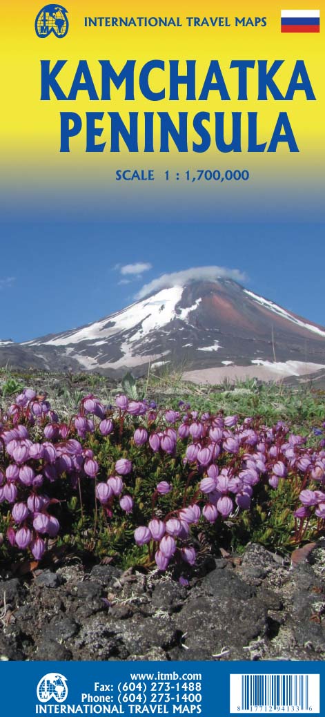
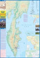
Russia: Kamchatka Peninsula
Ordinær pris 169,00 kr/
Mva inkludert
Frakt beregnes i kassen.
ITM har kart over hele verden og de spesialiserer seg på land litt utenfor allfarvei. Beliggenheten til landets nasjonalparker, historiske monumenter, de viktigste veiene o.L. Finner du inkludert i kartene. Samtlige landkart har ofte et bykart over hovedstaden.
Fra ITM: This is the most recently released title of our Russia series. In this revised edition, we have expanded the area of coverage to include the portion of Russia known as the Far East Republic and the eastern portions of Siberia (in January, we released Siberia itself). Lets start with the Kamchatka peninsula itself. This is a very interesting adventure travel destination, famous for its geothermal geysers and its isolation from the rest of Russia. There is only city of any size, Petropavlovsk Kamchatsky (which I genuinely hope is colloquially known as PK), the capital and location of the peninsulas only significant airport. We have included an inset map of the city. We also include a map of the famous Valley of Geysers (South of Klyuchi). Interestingly, the peninsula has a town called Esso. The other side of the sheet portrays a vast region from the Russian occupied island of Sakhalin and the Okhotsk Sea north to that portion of what we call the Arctic Ocean but is really a series of seas (this one being the East Siberian Sea) and west to the Lena River. The Trans Siberian railway west towards Moscow is shown, as well as connections into Mongolia and China. This is not a well known region of Russia and is definitely for the adventurer (I would to hear from anyone who has stayed at the hotel in Novaya Chara, which is as close to being the middle of nowhere I can imagine. actually, this portion of Russia is loaded with hotels and camping grounds. The map also shows a fascinating road going from close to the border with China all the way to a bay on the ocean. That would be quite a trip to take!
Publisert år: 2022
Innbinding: falset
Material: papir
Målestokk: 1:700,000

Russia: Lake Baikal
Ordinær pris 169,00 kr/
Mva inkludert
Frakt beregnes i kassen.
Tysk kartserie med flotte kart på slitesterkt plastpapir.
Road map of the Lake Baikal area on waterproof and tear-resistant paper, published by Reise Know-How as part of their highly acclaimed World Mapping Project. The map is double-sided to provide the best balance between a good scale and a convenient size sheet. Place names of towns and villages are given in both Cyrillic and Latin alphabets, whilst names of geographical features such as mountain ranges, peaks, rivers, lakes, etc. and of places of interest are in Latin alphabet only.
Contours with altitude colouring and numerous spot heights and pass heights show the topography of the surrounding area. Salt lakes, swamps, and salt marches are marked, as well as seasonal rivers, springs, waterfalls, and thermal spas. Road information includes unsurfaced tracks, paths and routes used in winter months, with intermediate driving distances and locations of petrol stations shown on main and secondary roads. Mountain passes are annotated to show when open to motorized traffic. Other transport details include railways with stations, ferry routes on the lake, and local airfields.
National parks, nature reserves and numerous places of interest are highlighted. Symbols show various types of accommodation (tourist hostel, mountain huts, etc.), hospitals, post offices, museums and monuments, archaeological sites, skiing areas, etc. Longitude and latitude lines are drawn at 30’ intervals. Map legend includes English.
Publisert år: 2019
Innbinding: falset
Material: plastpapir
Målestokk: 1:550000

Russia: Moscow
Ordinær pris 169,00 kr/
Mva inkludert
Frakt beregnes i kassen.
Dette store østerriske kartforlaget er kjent for sin klare kartografi og gode papirkvalitet. De kommer i alle målestokker, og flere av landkartene inneholder bykart og turistinformasjon.
Street plan of Moscow showing hotels, theatres, metro stations, bus route numbers and much besides. Minor streets are named in the Russian alphabet (so you can read the street signs) with major streets in Russian and Roman script. The main landmarks are named in Russian and English. An enlargement of the city centre is included, and also a further enlargement of the Kremlin and its immediate environs.
Publisert år: 2016
Innbinding: falset
Material: papir
Målestokk: 1:20000


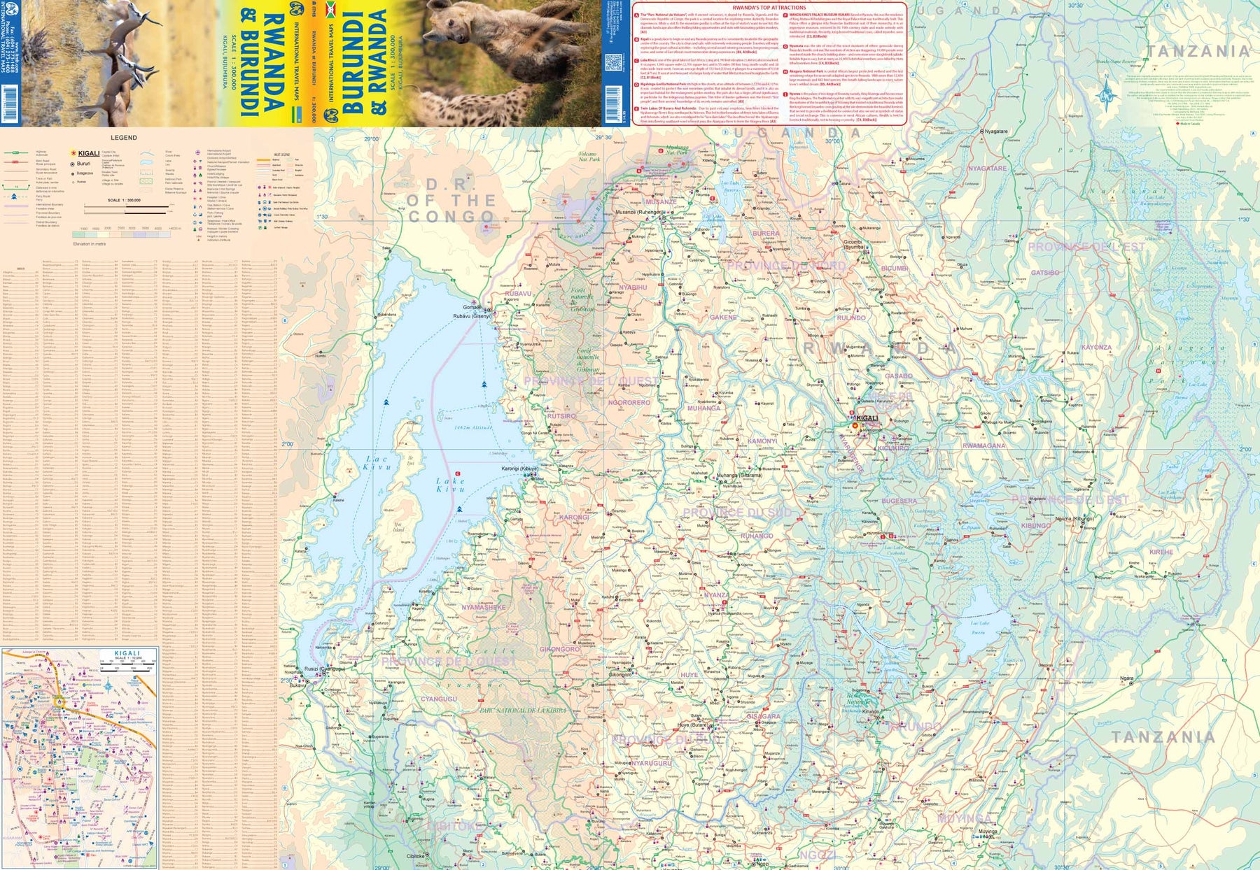
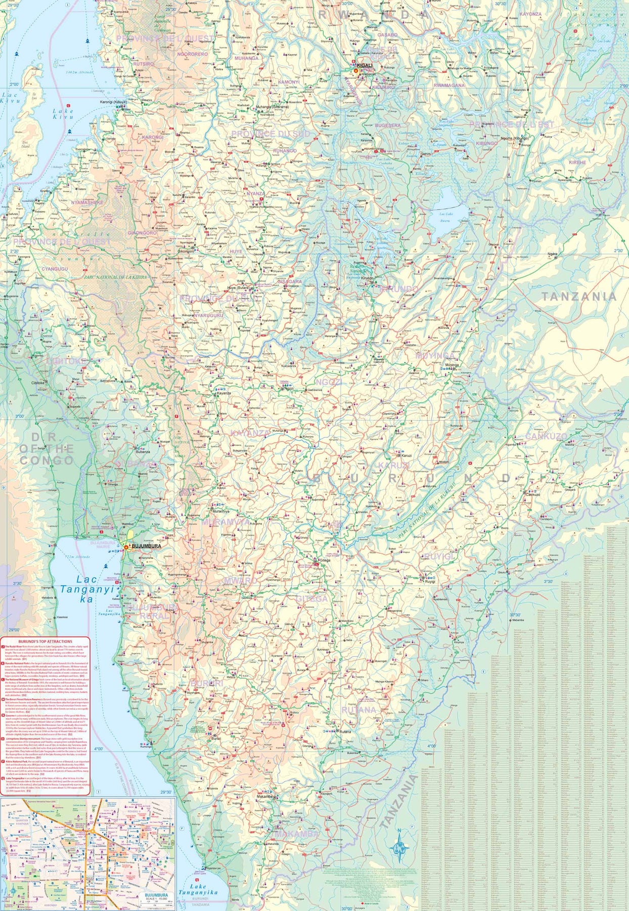
Rwanda & Burundi
Ordinær pris 199,00 kr/
Mva inkludert
Frakt beregnes i kassen.
ITM har kart over hele verden og de spesialiserer seg på land litt utenfor allfarvei. Beliggenheten til landets nasjonalparker, historiske monumenter, de viktigste veiene og lignende finner du inkludert i kartene. Samtlige landkart har ofte et bykart over hovedstaden.
- Publisert: 2023
- Innbinding: Falset
- Materiale: Papir
- Målestokk: 1:300 000

Røros
Ordinær pris 269,00 kr/
Mva inkludert
Frakt beregnes i kassen.
Vandringsguide & turkart.
På Røros, som er med på Unescos verdensarvliste, er natur og kultur tett sammenvevd, med svært mange spor etter gruvedrift som har preget området siden 1600-tallet. Denne guiden beskriver 27 fotturer som gir deg både kulturelle opplevelser og storslått utsikt.
- Publisert: Juni 2022
- Innbinding: Falset
- Materiale: Plastfiber
- Målestokk: 1:50 000

Saint Lucia & Martinique
Ordinær pris 149,00 kr/
Mva inkludert
Frakt beregnes i kassen.
ITM har kart over hele verden og de spesialiserer seg på land litt utenfor allfarvei. Beliggenheten til landets nasjonalparker, historiske monumenter, de viktigste veiene og lignende finner du inkludert i kartene. Samtlige landkart har ofte et bykart over hovedstaden.
Fra ITM: Saint Lucia in 1:45.000 and Martinique in 1:65.000. We have included an inset map of Castries, the capital, noting, among other things, the cruise ship terminals (there are two) and the inter-island ferry terminal. That is important because St. Lucia is now linked to neighbouring Martinique by a scheduled ferry service and it is very convenient for visitors wishing to enhance their visit by adding a day trip to Martinique. For this reason, we have added a full-page map of Martinique to the reverse side of the sheet. The ferry goes to Fort-de-France, the capital, and the map includes an inset of the city, showing where the ferry docks. Martinique, with its French heritage, is more exotic than most English-speaking Caribbean countries, but is friendly and somehow different.
It is considered an extension of France and thus of the European Union, so uses the Euro. Although the common language is French (or a variety of it), English is well-understood. Cars are readily available for hire and road conditions are good. The island even boasts a motorway, going to the island’s south coast. Both islands are important Caribbean travel destinations, with resort hotels concentrated on Marigot Bay and Rodney Bay in St. Lucia and in the Pont du Bout peninsula of Martinique. The map has a double-sided cover for ease of marketing.
- Publisert: 2018
- Innbinding: Falset
- Materiale: Papir
- Målestokk: 1:45 000, 1:65 000

Lonely Planet San Francisco
Ordinær pris 119,00 kr/
Mva inkludert
Frakt beregnes i kassen.
Lonely Planet City Map er slitesterkt og vanntett, med en hendig slipcase og et format som er lett å brette. Få mer ut av kartet og reisen din med bilder og informasjon om byattraksjoner, transportkart, reiseruteforslag, omfattende gate- og nettstedsindeks og praktiske reisetips. Med dette brukervennlige navigasjonsverktøyet i baklommen kan du virkelig komme til hjertet av din destinasjon!
- Publisert: Sep, 2016
- Utgave: 1.utg
- Innbinding: Falset
- Material: Plast papir

Sardinia
Ordinær pris 189,00 kr/
Mva inkludert
Frakt beregnes i kassen.
Marco polo er svært detajerte kart som er praktiske og enkle i bruk. 7 klistremerker for å markere spesifikke steder gjør det enda enklere å planlegge reisen. Alle kartene inneholder en omfattende index for enkelt å finne frem.
Fully updated, Marco Polo maps feature completely up-to-date, digitally generated mapping. The high quality cartography with distance indicators and scale converters aid route planning. Includes a city map of Cagliari. Major sights and key points of interest are marked on the map by numbered stars and these are listed in the index booklet with a brief description to help travellers pick the best places to see en route. Comprehensive index.
Publisert: 2024
Innbinding: falset
Material: papir
Målestokk: 1:200,000

Lonely Planet Scotland
Ordinær pris 119,00 kr/
Mva inkludert
Frakt beregnes i kassen.
Lonely Planet Planning Map er slitesterkt og vanntett, med en hendig slipcase og et format som er enkelt å brette. Få mer ut av kartet og reisen din med bilder og informasjon om toppattraksjoner i landet, reiseruteforslag, en transportguide, planleggingsinformasjon, temalister og praktiske reisetips. Med dette brukervennlige navigasjonsverktøyet i baklommen kan du virkelig komme til hjertet av din destinasjon!
- Publisert: Juni, 2025
- Utgave: 2. utgave
- Innbinding: Falset
- Materiale: Plastpapir

Scotland & Northern England
Ordinær pris 189,00 kr/
Mva inkludert
Frakt beregnes i kassen.
- Publisert: September 2023
- Innbinding: Falset
- Materiale: Papir
- Målestokk: 1:300 000

Lonely Planet Seattle
Ordinær pris 119,00 kr/
Mva inkludert
Frakt beregnes i kassen.
Lonely Planet City Map er slitesterkt og vanntett, med en hendig slipcase og et format som er lett å brette. Få mer ut av kartet og reisen din med bilder og informasjon om byattraksjoner, transportkart, reiseruteforslag, omfattende gate- og nettstedsindeks og praktiske reisetips. Med dette brukervennlige navigasjonsverktøyet i baklommen kan du virkelig komme til hjertet av din destinasjon!
- Publisert: Sep, 2017
- Utgave: 1.utg
- Innbinding: Falset
- Material: Plast papir

Lonely Planet Seoul
Ordinær pris 119,00 kr/
Mva inkludert
Frakt beregnes i kassen.
Lonely Planet City Map er slitesterkt og vanntett, med en hendig slipcase og et format som er lett å brette. Få mer ut av kartet og reisen din med bilder og informasjon om byattraksjoner, transportkart, reiseruteforslag, omfattende gate- og nettstedsindeks og praktiske reisetips. Med dette brukervennlige navigasjonsverktøyet i baklommen kan du virkelig komme til hjertet av din destinasjon!
- Publisert: August 2024
- Utgave: 2. utgave
- Innbinding: Falset
- Materiale: Vannfast papir
- ISBN: 9781787016453

Serbia
Ordinær pris 239,00 kr/
Mva inkludert
Frakt beregnes i kassen.
Gizi Map er en serie presise kart med detaljer og opplysninger over både populære og mindre populære reisemål. Dekker ofte områder der få andre kartprodusenter dekker.
- Publisert: 2020
- Innbinding: Falset
- Materiale: Papir
- Målestokk: 1:500 000

Serbia North
Ordinær pris 189,00 kr/
Mva inkludert
Frakt beregnes i kassen.
Dette store østerriske kartforlaget er kjent for sin klare kartografi og gode papirkvalitet. De kommer i alle målestokker, og flere av landkartene inneholder bykart og turistinformasjon.
Northern Serbia at 1:200,000 on a large, detailed, double-sided road map from Freytag & Berndt, with its index booklet also providing street plans of central Belgrade, Kragujevac and Novi Sad. Coverage extends south to northern point in the border with Montenegro, with Belgrade included on both sides of the map. Names of towns and villages are in both Cyrillic and Latin alphabet.
Topography is indicated by relief shading with spot heights, plus colouring for the forested areas; names of geographical features such as mountain ranges, etc. are mainly in the Latin alphabet only. The map shows the road network in much detail, including driving distances on many small local roads, steep gradients, roads with seasonal closures or restricted traffic, motorway services, etc. Railway lines are shown with stations and domestic airports are marked. Symbols indicate various places of interest, including campsites and youth hostels. The map has latitude and longitude lines at 10’ intervals. Multilingual map legend includes English.
Publisert år: 2020
Innbinding: falset
Material: papir
Målestokk: 1:200000

SÉRKORT SKAFTAFELL
Ordinær pris 139,00 kr Salgspris 69,50 kr Spar 50%/
Mva inkludert
Frakt beregnes i kassen.
Publisert år: 2008
Innbinding: fal
Material: papir
Målestokk: 1:100.000
Innbinding: fal
Material: papir
Målestokk: 1:100.000

Lonely Planet Seville
Ordinær pris 119,00 kr/
Mva inkludert
Frakt beregnes i kassen.
Lonely Planet City Map er slitesterkt og vanntett, med en hendig slipcase og et format som er lett å brette. Få mer ut av kartet og reisen din med bilder og informasjon om byattraksjoner, transportkart, reiseruteforslag, omfattende gate- og nettstedsindeks og praktiske reisetips. Med dette brukervennlige navigasjonsverktøyet i baklommen kan du virkelig komme til hjertet av din destinasjon!
- Publisert: Februar 2025
- Utgave: 2. utgave
- Innbinding: Falset
- Materiale: Vannfast papir

Seville
Ordinær pris 99,00 kr/
Mva inkludert
Frakt beregnes i kassen.
Kart i postkortstørrelse. Folder seg ut som en popoutbok når du åpner dem. Fargerik turistinformasjon med kart over metro og busstraseer, landemerker og lignende. Veldig enkelt å håndtere.
- Publisert: 2025
- Innbinding: Pop up-kart
- Materiale: Papp, papir