1151 produkter
1151 produkter


1151 produkter
Osloguiden
Ordinær pris 289,00 krNordic Maps har laget en guide med 31 av Oslos populære attraksjoner. Guiden er i formatet 50 x 70 cm. På den ene siden er det et bykart, på den andre siden en kort engelsk tekst om hver attraksjon.
QR-kodene på attraksjonene leder direkte til Google Maps’ veibeskrivelse (til fots). Noen av bildene i guiden har også fått AR-funksjon, det vil si at du får opp video av attraksjonen når du skanner bildet med en AR-app. På videoen er det også lagt på en guide (generert ved hjelp av kunstig intelligens) som forteller om attraksjonen på bildet.
About this guide - Oslo guide with augmented reality:
Nordic Maps has picked out 31 of the most popular sights in Oslo, from the classic must-sees to the more hidden gems.
How to use the guide: Download an app (QR code on back cover of guide). Scan images with AR (augmented reality) logo to see videos from the sights and attractions. In addition, you will find that each attraction has a QR code to Google Maps. Use your phones QR Code reader or open your camera app to scan the codes.
Please note that only images with AR logo can be scanned with the app. The content shown will be active for at least a year after you purchase.
Oxford
Ordinær pris 99,00 krKart i postkortstørrelse. Folder seg ut som en popoutbok når du åpner dem. Fargerik turistinformasjon med kart over metro og busstraseer, landemerker og lignende. Veldig enkel å håndtere.
Lonely Planet Oxford & the Cotswolds
Ordinær pris 119,00 krLonely Planet Planning Map er slitesterkt og vanntett, med en hendig slipcase og et format som er enkelt å brette. Få mer ut av kartet og reisen din med bilder og informasjon om toppattraksjoner i landet, reiseruteforslag, en transportguide, planleggingsinformasjon, temalister og praktiske reisetips. Med dette brukervennlige navigasjonsverktøyet i baklommen kan du virkelig komme til hjertet av din destinasjon!
PAAMIUT/IVITTUUT
Ordinær pris 159,00 krPadova
Ordinær pris 199,00 krPakistan
Ordinær pris 169,00 krTysk kartserie med flotte kart på slitesterkt plastpapir.
Pakistan on a light, waterproof and tear-resistant, indexed map with topographic and tourist information, published by Reise Know-How as part of their highly acclaimed World Mapping Project. The map is double-sided to provide the best balance between a good scale and a convenient size sheet.
Topography is shown by altitude colouring with spot heights, mountain passes and names of mountain ranges, deserts, etc. Seasonal rivers and lakes, swamps, salt pans are also marked. Internal administrative boundaries are shown with names of the provinces.
Road network includes local roads, indicating driving distances on main routes and most secondary roads. Railways and local airfields and ports are also shown. Symbols mark locations of various places of interest, including UNESCO world heritage sites, archaeological remains, national parks and other protected areas, etc. The map has a grid with latitude and longitude at intervals of 1º and an extensive index of localities with a separate list of national parks and reserves. Map legend includes English.
Publisert år: 2019
Innbinding: falset
Material: plastpapir
Målestokk: 1:1300000
Palermo
Ordinær pris 169,00 kr
Panama
Ordinær pris 199,00 krITM har kart over hele verden og de spesialiserer seg på land litt utenfor allfarvei. Beliggenheten til landets nasjonalparker, historiske monumenter, de viktigste veiene o.L. Finner du inkludert i kartene. Samtlige landkart har ofte et bykart over hovedstaden.
Fra ITM: The Central American country of Panama is actually and east-west country, not a north-south one as one might expect. Its historic claim to fame is two-fold. It was here that Spanish conquistadors first set eyes on the vast Pacific Ocean, and it is here that much of the world's commercial goods pass from the Pacific to the Atlantic. The Canal is extremely important, and a "must see" attraction, but the country offers much more. Santa Catalina is a world-class surfing destination. The Pearl Islands feature virgin forest and pristine beaches. Boquette, in the northern mountains, is the valley of the flowers. Panama City is a vibrant economic centre for shopping. In recent years, Panama has invested heavily in tourism. The roads are excellent, the people are friendly, the restaurants are excellent, and the country is peaceful. Who could ask for more?
Inkl. bykart over Panama City
Publisert år: 2024
Innbinding: falset
Material: plastpapir
Målestokk: 1:400,000
Panama: Panama Canal & Central
Ordinær pris 169,00 krITM har kart over hele verden og de spesialiserer seg på land litt utenfor allfarvei. Beliggenheten til landets nasjonalparker, historiske monumenter, de viktigste veiene og lignende finner du inkludert i kartene. Samtlige landkart har ofte et bykart over hovedstaden.
Fra ITM: One of the world's great travel adventures is sailing through the Panama Canal, which we did last year (see cover photo). Panama itself is a large enough country that the canal, which is visited annually by millions of passengers, cannot be shown in meaningful detail. So, whether one is on board one of the many cruise ships squeezing into the Miraflores Locks or are a visitor ashore watching, the canal is a great attraction. The map is double-sided, with central Panama (the part most visited) filling side one. Side two is divided in half along the central fold. A very detailed map of Panama City fills the left side, and the first-ever map of the canal itself fills the other. This is a marvelously portrayed rendition of the most important canal in the world. Even at this scale, the locks themselves are thin lines on the sheet, but they're there.
Publisert år: 2020
Innbinding: falset
Material: vanntett papir
Målestokk: 1:100,000 / 300,000
Paraguay & Bolivia South
Ordinær pris 199,00 krITM har kart over hele verden og de spesialiserer seg på land litt utenfor allfarvei. Beliggenheten til landets nasjonalparker, historiske monumenter, de viktigste veiene og lignende finner du inkludert i kartene. Samtlige landkart har ofte et bykart over hovedstaden.
Fra ITM: Expanding the area of coverage benefits visitors combining Paraguay and Bolivia into one trip. The first side covers Bolivia from La Paz south to the Paraguayan border, with inset maps of Potosi and Santa Cruz. The second side concentrates on Paraguay itself, with inset maps of Asuncion, the Asuncion region, and northern Paraguay. Small bits of bordering countries also are included. Road connections within Paraguay have been shown to good advantage. Both countries, being land-locked, are somewhat isolated, making travel to them something more adventuresome than visits to neighbouring countries. However, both are hospitable, safe, and tourist-friendly.
Inkl. bykart over: Asunción.
Paros & Antiparos
Ordinær pris 149,00 kr Salgspris 74,50 kr Spar 50%Pica d’Estats; Mont Roig
Ordinær pris 289,00 krLonely Planet Porto
Ordinær pris 119,00 krLonely Planet City Map er slitesterkt og vanntett, med en hendig slipcase og et format som er lett å brette. Få mer ut av kartet og reisen din med bilder og informasjon om byattraksjoner, transportkart, reiseruteforslag, omfattende gate- og nettstedsindeks og praktiske reisetips. Med dette brukervennlige navigasjonsverktøyet i baklommen kan du virkelig komme til hjertet av din destinasjon!
Portugal
Ordinær pris 199,00 krITM har kart over hele verden og de spesialiserer seg på land litt utenfor allfarvei. Beliggenheten til landets nasjonalparker, historiske monumenter, de viktigste veiene o.L. Finner du inkludert i kartene. Samtlige landkart har ofte et bykart over hovedstaden.
Fra ITM: We are very pleased to be able to release a double-sided detailed map of Portugal. Although we have included the country in previous maps, it was always as an adjunct to another map (Spain and Portugal, Portugal and Southern Spain etc.), so it is high time that this very nice popular country had its own ITM map. Being a long, rather thin country, Side 1 concentrates on Lisbon and the southern half of Portugal with a detailed inset map of Lisbon. It also includes the Spanish provinces of Huelva and Badajoz. Side 2 covers the northern half of the country along with portions of neighbouring Spanish provinces. As a country, Portugal has a wealth of touristic attractions and we have included as many as we can on this map without cluttering it – castles, palaces, fortresses, cathedrals and churches, dozens of museums, beaches, a few hotels, mines, monuments, and just about everything a visitor would want to have. Of course, motorways, highways, secondary routes, rail lines, ferry services, and geographic heights of land are also included; altogether, a fabulous map for a wonderful country.
Publisert år: 2025
Innbinding: falset
Material: Papir
Målestokk: 1:500,000
Portugal: Azores
Ordinær pris 199,00 krPortugal: Azores Walking & Cycling Map Set
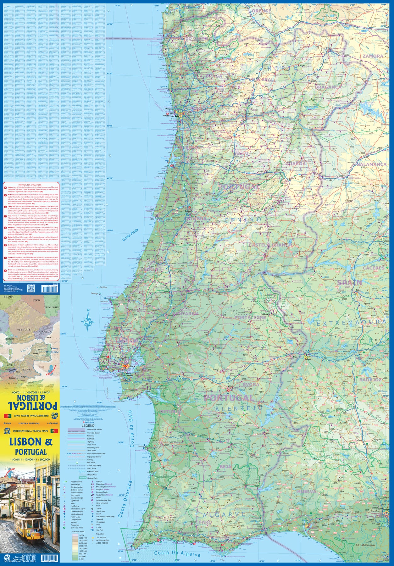
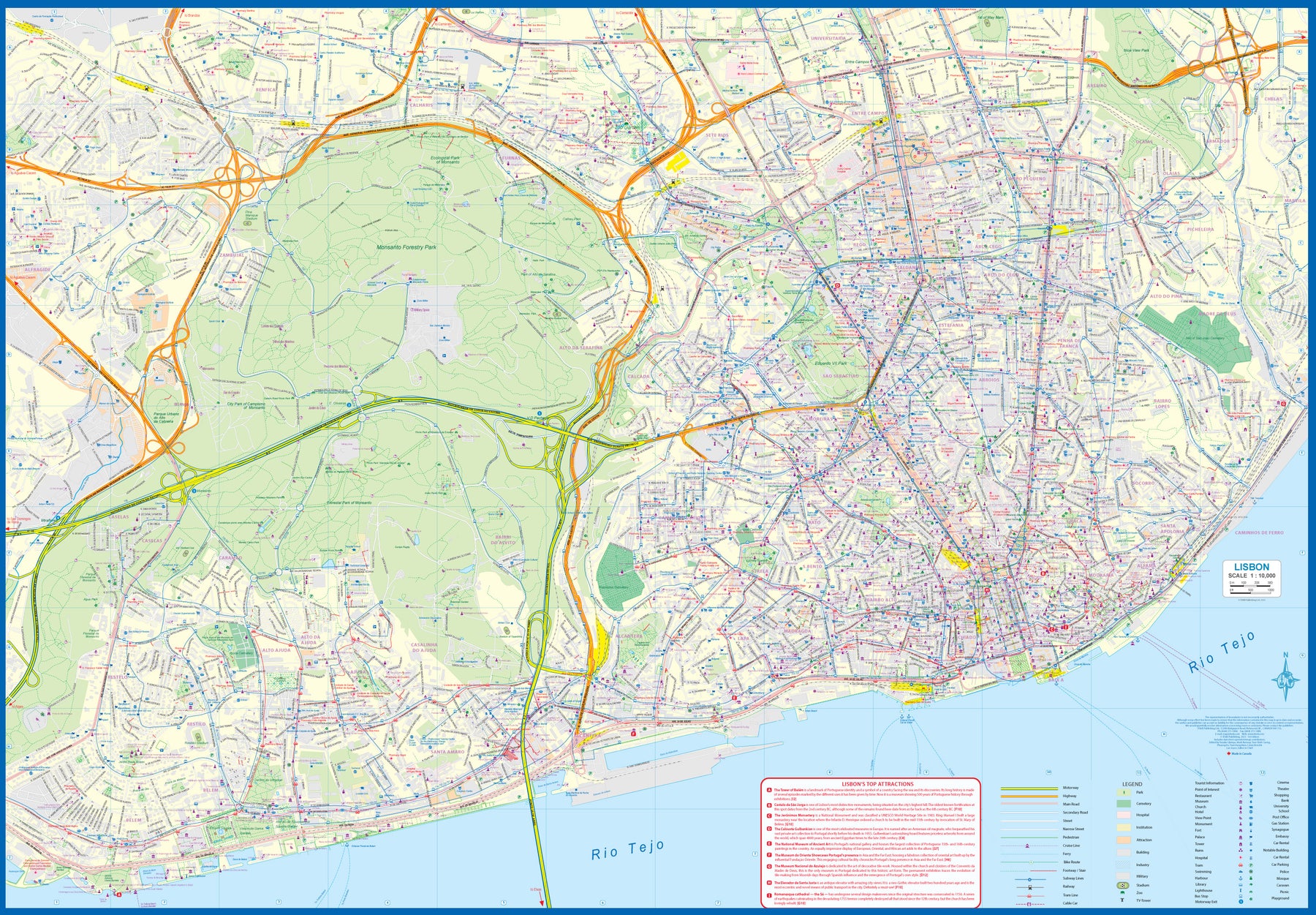
Ordinær pris 219,00 krPortugal: Lisbon & Portugal
Ordinær pris 199,00 krThe city of Lisbon is one of the most attractive in Europe. It is an ancient city, but most of its architecture dates from the Victorian era. It has a fascinating number of tram lines, and the trams tend to be an experience worth the trip. One graces our cover. There is no cheaper way to explore this city than to climb aboard and let the rails decide your destination!
Coverage extends from the northern and western motorways to the southerly Rio Tejo and the national museum, so shows the city quite comprehensively. Almost half of the map area is of the massive Monsanto Park, one of the largest urban parks in the world. The reverse side is equally important, in that it presents our first-ever map dedicated to showing the charms of the entire country of Portugal. A bit of western Spain is included due to the unevenness of the border, but the map goes from the northernmost tipoff Castelo to the southernmost expanse of the Costa Do Algarve, showing touristic attractions, historic sites, beaches, museums, rail connections, and major parks.
The map is printed on waterproof stone paper, a recent technological innovation that is gradually replacing plastic.
Lonely Planet Prague
Ordinær pris 119,00 kr
Lonely Planet City Map er slitesterkt og vanntett, med en hendig slipcase og et format som er lett å brette. Få mer ut av kartet og reisen din med bilder og informasjon om byattraksjoner, transportkart, reiseruteforslag, omfattende gate- og nettstedsindeks og praktiske reisetips. Med dette brukervennlige navigasjonsverktøyet i baklommen kan du virkelig komme til hjertet av din destinasjon!
Prague
Ordinær pris 99,00 krKart i postkortstørrelse. Folder seg ut som en popoutbok når du åpner dem. Fargerik turistinformasjon med kart over metro og busstraseer, landemerker og lignende. Veldig enkel å håndtere.
Publisert år: 2025
Innbinding: pop
Material: papp, papir
Prokletije - Albanian Alps
Ordinær pris 299,00 krA series specially designed for lovers of large journeys and mountain walks.
A detailed scale and complete tourist information to help you plan your trekking. Thanks to the laminated surface and flex-folding, the Trekking maps of TerraQuest will guide you anywhere, even in the most extreme conditions. You can make your own notes on the maps and erase them without damaging the maps.
Provence & French Riviera (Alps)
Ordinær pris 199,00 krLet the Marco Polo Provence, Alps, Cote d’Azur Road Map guide you around this beautiful region of southern France. Discover the glamour of the Cote D’Azur, the glittering sea, the glorious resorts and charming towns with this highly durable, detailed, touring map of the French Riviera with this highly durable, detailed touring map. It folds away easily and is always on standby to help when you're stuck. Perfect touring map - the scale is 1 : 275 000 ideal to help you tour the country by car or campervan.
Puerto Rico & Virgin Islands
Ordinær pris 169,00 krITM har kart over hele verden og de spesialiserer seg på land litt utenfor allfarvei. Beliggenheten til landets nasjonalparker, historiske monumenter, de viktigste veiene o.L. Finner du inkludert i kartene. Samtlige landkart har ofte et bykart over hovedstaden.
Fra ITM: The American territories of Puerto Rico and the US Virgin Islands are anomalies in the modern world, neither fish nor fowl, as the saying goes. Although the residents are American citizens, they have no representation in Congress and are not allowed to vote in national elections. The lesser-known British Virgin Islands are included on this double-sided map. The BVI is still a British colony, consisting of about 20 islands, capitaled in Road Town (inset included). Puerto Rico (1:190.000) is a large, rectangular island, capitaled by San Juan (inset included) and is a major cruise ship point of origin as well as being home to resort communities all over the main island. Ferries connect to outlying islands. The VI portion was purchased from Denmark in 1917 and retains a colonial European charm. There are three main islands – St. Croix, St. Thomas, and St. John – and the map includes inset maps of Charlotte Amalie, Cruz Bay, Christiansted, and Frederiksted. Each side of the map sheet includes a listing of top attractions. Ferry routes to the BVI are shown, as well as water connections between the islands. Virgin islands 1:85.000.Legend Includes:Roads by classification, Rivers and Lakes, National Park, Airports, Points of Interests, Highways, Main Roads, Zoos, Fishing, and much more...
Publisert år: Aug. 2021
Innbinding: falset
Material: vanntet tpapir
Målestokk: 1:190000/1:85,000
QIMUSSERIARSUAQ (MELVILLE BUGT)
Ordinær pris 219,00 krRando Velo 11: Verdun
Ordinær pris 199,00 kr Salgspris 99,50 kr Spar 50%Rando Velo 12: Luxembourg
Ordinær pris 199,00 krRando Velo 1: East & Vest Flanders
Ordinær pris 199,00 kr Salgspris 99,50 kr Spar 50%Rando Velo 2: Antwerpen
Ordinær pris 199,00 kr Salgspris 99,50 kr Spar 50%Rando Velo 4: Lille
Ordinær pris 199,00 kr Salgspris 99,50 kr Spar 50%